
Alameda County Quarterly Caltrans Update
Strengthen stewardship and drive efficiency - Lead climate action-Advance equity and livability in all communities
Welcome back to the Alameda County Caltrans E-Newsletter!
LINKS:
- Customer Service Request
Online Maintenance Requests - Public Records Request
Public Information Request Form - Right Of Way & Surveys
Maps and Surveys of Caltrans Properties and Highways - Encroachment Permits
Working with Caltrans - Lane Closures
Planned Lane Closures - Job Opportunities
Work for Caltrans - Contractor's Corner
Work with Caltrans
Visit our project website for additional updates.
For project questions & to sign up for our weekly newsletter, please contact us at EMAIL
Our goal is to provide you with the status, resources, content, data and links to various information related to Caltrans work in Alameda County.
Alameda County is a dynamic and integral part of the Bay Area, known for its diverse communities, economic vitality, and cultural richness. Home to a blend of historic landmarks, thriving urban centers, and scenic open spaces, the county serves as a key hub for innovation, education, and commerce. Positioned between the dynamic metropolis of San Francisco and the growing inland regions, Alameda County benefits from a strong transportation network that connects its vibrant cities and neighborhoods. With a mix of coastal charm, suburban comfort, and urban energy, it offers residents and visitors a variety of experiences, from waterfront attractions to renowned dining, arts, and entertainment scenes.
Alameda County is actively pursuing and working on a range of transportation projects aimed at enhancing mobility, safety, and accessibility for its diverse communities. From highway upgrades and transit improvements to bike and pedestrian-friendly infrastructure, these efforts are designed to create a more efficient and sustainable transportation network. By investing in these critical projects, Alameda County is strengthening regional connectivity, reducing congestion, and ensuring a safer, more accessible future for all residents and visitors.
What's Happening Around Town?
UPDATE ON CURRENT AND FUTURE CONSTRUCTION PROJECTS
🦺 I-80/Gilman Interchange Project
Where: Gilman Street in Berkeley
When: Project Completed Spring 2025.
Click Here to Watch the Ribbon Cutting Ceremony
Why: The wait is finally over. The I-80 Gilman Interchange project is now complete, delivering long-awaited improvements to traffic flow, safety, and accessibility. The new roundabouts are already easing congestion and shortening queues at this busy interchange. Most notably, the new bike and pedestrian overcrossing is open, providing a safer and more direct connection for non-drivers traveling through the area and along the Bay Trail. Caltrans Bay Area Director Dina El-Tawansy said, "These upgrades improve mobility for all users—drivers, cyclists, and pedestrians alike." After months of construction, the Gilman Interchange is now transforming how people move through the area, making commutes smoother and waterfront access easier for everyone.
🦺 I-680 Paving Project (Sunol, Dublin, Pleasanton, San Ramon)
Where: Between Sunol and San Ramon
When: On Scheduled to be Completed Spring 2027
Why: The I-680 Paving Project is bringing long-term roadway improvements to one of the region’s busiest corridors. By repaving worn-out sections and upgrading key infrastructure, this project will reduce vehicle wear and tear, improve traffic flow, and enhance overall safety. The northbound I-680 project involves rehabilitating the existing roadway, while the southbound I-680 project includes both the addition of a new express lane and rehabilitation of the existing roadway. Construction activities, including paving and drainage improvements, are underway with both daytime and nighttime work. When complete, travelers can look forward to a smoother and more reliable driving experience along I-680.
🦺 Alameda County I-880 Capital Preventive Maintenance (Fremont)
Where: Between Fremont Blvd and the Alameda County/Santa Clara County line.
When: Work resumed April 2025, with an expected completion by late 2025.
Why: The project focuses on extending pavement life and improving ride quality along this vital stretch of I-880. Key upgrades involve replacing asphalt surfacing, bringing curb ramps up to ADA standards, enhancing pedestrian crossings with flashing beacons, and updating traffic systems and signage. Overnight lane closures are in place to facilitate the work while reducing daytime traffic impacts.
🦺 Oakland Alameda Access Project (Oakland/Alameda)
Where: I-880/I-980 and the Posey and Webster Tubes, spanning parts of Oakland’s Chinatown, Jack London District, and the City of Alameda.
When: Construction is scheduled to begin in Fall 2025
Why: This project is designed to improve traffic flow, enhance safety, and create better connections between Oakland and Alameda. By reducing freeway-bound traffic in residential areas, adding safer pedestrian and bicycle paths, and reconfiguring freeway ramps, it will make travel smoother and safer for all road users.
🦺 I-680/I-580/I-238 Rehabilitation Project (Pleasanton/Castro Valley)
Where: Between I-680/I-580 Interchange in Pleasanton to I-580/I-238 Interchange in Castro Valley.
When: Construction on schedule to be completed by Winter 2026.
Why: This project aims to address safety concerns, improve ride quality, and extend the service life of the pavement. Key activities include replacing concrete slabs, constructing concrete barriers, and upgrading infrastructure to current standards. These improvements will enhance the overall driving experience and ensure long-term durability of the roadway.
🦺 I-680/I-238 Mission San Jose Separation Deck Rehab Project (Fremont)
Where: I-680/I-238 separation in Fremont
When: Construction on schedule to be completed by Spring 2026.
*Two 55 Hour Weekend Closures schedules for July 2025. *
Why: This rehabilitation project aims to enhance safety, reliability, and longevity for this section of I-680. Work includes repairing the bridge deck, replacing joints, and upgrading approach slabs. These improvements will extend the life of the bridge, improve ride quality, and maintain a safe transportation network for all travelers.
Where: All of Interstate 980 in West Oakland
When: The Vision 980 Study is currently underway, with community engagement and planning efforts shaping the future of the corridor.
Why: Built through racially discriminatory policies and redlining, I-980 displaced families, divided communities, and contributed to economic disinvestment. Today, the freeway is seen as a barrier to mobility and opportunity. This study aims to reimagine the corridor through a community-driven process, exploring possibilities such as new housing, business opportunities, open space, public transit connections, and safer pedestrian and bike access. Click here to learn more.
 🦺 Caldecott Tunnel Rehab & Ventilation Upgrade (Orinda/Oakland)
Where: SR-24, Caldecott Tunnel (Bores 1, 2, and 3), located between Alameda and Contra Costa Counties.
When: Construction estimated to start Fall 2026.
Why: This project will rehabilitate and upgrade Bores 1, 2, and 3 of the Caldecott Tunnel to extend tunnel life, address water and structural damage, and improve emergency response systems. Key improvements include concrete repair, electrical and lighting system upgrades, and the installation of new jet fans and sprinkler systems for improved tunnel ventilation and fire suppression. Identified as a high-priority risk in a statewide ventilation capacity assessment, these upgrades are essential to enhance safety and reduce long-term maintenance needs.
 🦺 San Pablo Avenue (SR-123) Accessibility Improvements (Berkeley/Albany)
Where: On San Pablo Ave (SR-123) from Ashby Ave (Berkeley) to Contra Costa County line
When: Construction is currently 99% complete and undergoing final inspections. The project is expected to reach construction completion by July 2025.
Why: This project upgrades pedestrian facilities to meet Americans with Disabilities Act (ADA) standards by replacing uplifted sidewalks caused by tree roots, repairing cracked sidewalks, reconstructing non-standard driveways, and installing or replacing damaged tactile warning strips. These improvements enhance safety and accessibility for all users along the corridor.
 🦺 Arroyo de la Laguna Bridge Project (Sunol)
Where: SR-84 (Niles Canyon Road) in Sunol.
When: The project is currently in the design phase, with construction anticipated to begin in Summer 2026.
Why: The project will replace the existing bridge to meet modern design and safety standards. Improvements will support long-term reliability, enhance traffic safety, and ensure better alignment with nearby roadways and structures.
 🦺 I-580 Broadband Middle-Mile Network Installation (Oakland/San Leandro)
Where: On I-580 from Dutton Ave Undercrossing to SR-24/I-580 Junction.
When: Construction on schedule to be completed by Spring 2026.
Why: This project supports the development of California’s Middle-Mile Broadband Network, which will expand access to high-speed internet and improve connectivity for communities across the state. The infrastructure will help close the digital divide by enabling future broadband service in underserved areas.
![]() 🦺 I-80 Improvement Project (Berkeley)
🦺 I-80 Improvement Project (Berkeley)
Where: On I-80 from University Avenue to Gilman Street.
When: Currently in the planning phase.
Why: This project focuses on safety and infrastructure improvements along the I-80 corridor. Planned work includes installation of catch basins (CB) for drainage, wrought iron fencing, lighting modifications, and landscaping to enhance the corridor’s appearance and environmental resilience.
🦺 Niles Canyon (SR-84) Flashing Beacons System Installation (Sunol)
Where: On Sr-84 (Niles Canyon) from Fremont to Sunol.
When: Construction on schedule to be completed by Fall 2025.
Why: This project will install a flashing beacon system to improve visibility and enhance traffic safety at key locations along the corridor. The beacons will provide additional warnings to motorists, especially in areas with higher pedestrian activity or limited sight distance.
🦺 SR-84 Widening & Interchange Improvement Project (Sunol)
Where: On SR-84 between Ruby Hill Drive and the I-680 Interchange.
When: Construction on schedule to be completed by Winter 2025.
Why: This project is designed to reduce congestion, enhance safety, and improve regional mobility between I-580 and I-680. It will upgrade SR-84 to expressway standards, improve traffic circulation at the SR-84/I-680 interchange, and add new HOV/express lane segments. The project also includes new bike infrastructure at the interchange, better ramp connectivity, and modernized roadway design to support all road users.
![]() 🦺 West Oakland Links (Oakland)
🦺 West Oakland Links (Oakland)
Where: From Mandela Parkway in West Oakland to the Bay Bridge East Span Pathway, connecting to the Bay Trail.
When: Currently in the Design phase.
Why: The West Oakland Link is a proposed 1.1-mile elevated pedestrian and bicycle pathway that will close a critical gap in the active transportation network. It will safely connect West Oakland to the shoreline, the Bay Trail, and downtown San Francisco.
 🦺I-580 Truck Scale Study- (Oakland)
Where: Along the I-580 corridor through Alameda County.
When: The Study is currently underway. Click here to stay informed.
Why: This study will evaluate the potential effects of removing the truck weight restriction (truck ban) on I-580. It aims to understand how lifting the ban could affect safety, traffic flow, efficiency, and equity, particularly for underserved communities along the I-580 and I-880 corridors. The goal is to inform decisions about improving freight mobility while addressing longstanding environmental and public health concerns.
🦺 I-580 Westbound HOV Lane Extension (Oakland)
Where: On I-580 from Harrison Ave to the I-580/I-80 connector.
When: Construction set to begin Summer 2025.
Why: This project will convert an existing lane into a High-Occupancy Vehicle (HOV 3+) lane, requiring three or more passengers per vehicle. The goal is to reduce congestion and improve travel times for carpoolers and transit riders heading toward the San Francisco-Oakland Bay Bridge.
 🦺 SR-61 Capital Preventative Maintenance Project (Alameda)
Where: On SR-61 starting from Davis St (Alameda) through Oakland and San Leandro.
When: Construction is scheduled to begin in January 2026
Why: This project will preserve pavement, improve ride quality, and enhance safety along SR-61. Work includes pavement rehabilitation, drainage upgrades, curb ramp replacements, Class IV bike lanes on Doolittle Drive, flashing beacons at key curves, and pedestrian safety improvements at Otis Drive and Mound Street.
What's Happening Around Town?
UPDATE ON CURRENT MAINTENANCE HIGHLIGHTS
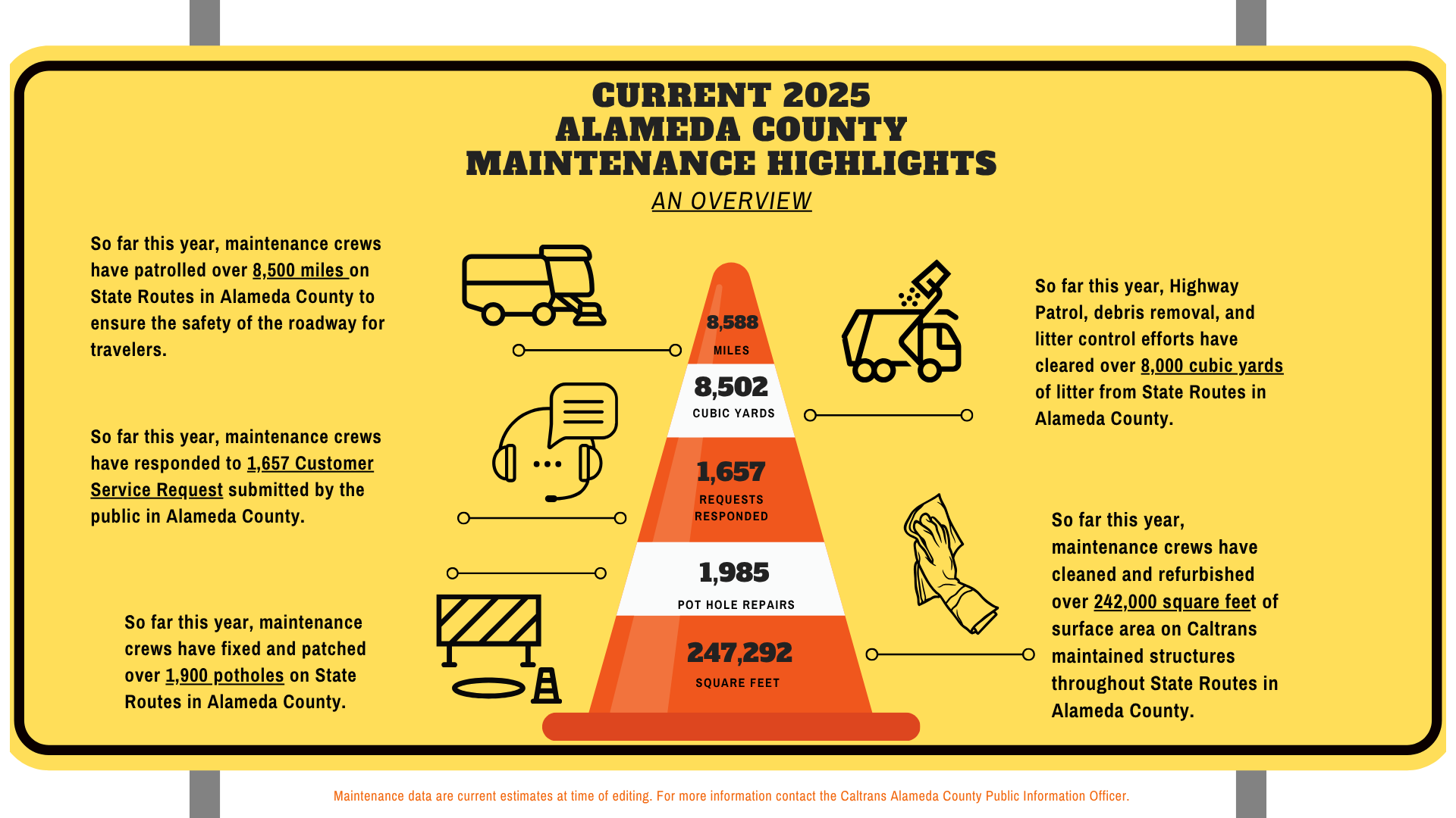
*Maintenance data are current estimates at time of editing. For more information contact the Caltrans Alameda County Public Information Officer*


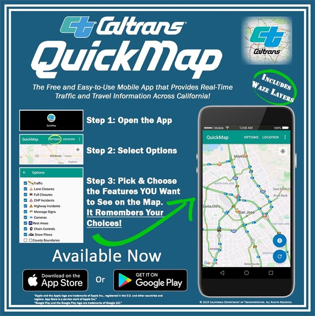
A Driver’s Best Resource on the Highway
Navigating the highways in the Bay Area has it’s challenges. The highways in San Mateo County are no exception. Whether you're commuting to and from the Silicon Valley or making your way towards San Francisco for an eventful outing. We have all experience the impact of busy highways. A great resource for motorists is QuickMap. It is both a mobile app and a website (quickmap.dot.ca.gov) that provides real time traffic information, including road conditions, facility information and resources for commercial vehicles. A highlight for motorists is the ability to see what lane closures and/or traffic incidents may be along your route. The detailed information allows motorists to make informed decisions as they travel the highways. The listed lane closures provide start and stop times of closures and the listed traffic incidents provide additional information such as which lane the accident ahead is in. This type of information can assist motorists in lessening delays. Please consider checking QuickMap before you drive.
Setting the PACE: Public Affairs Customer Engagement Site is Now Live!
District 4 is proud to announce the launch of our new Customer Service Request (CSR) platform. PACE, the Public Affairs Customer Engagement site, provides a regularly updated breakdown of services requested and rendered across the district.
- The CSR dashboard aims to provide an overview of the responsiveness to maintenance services requested across the nine Bay Area counties.
- The data represented as month-to-date falls within a rolling 30-day Service Level Agreement (SLA) and is updated weekly.
- We strive to close 60% (or more) of all monthly service requests received via the CSR website portal.
- For more information or to leave comments/suggestions, please contact D4CSLTEAM@dot.ca.gov.
- To report a highway issue/problem, please submit a CSR ticket through the Customer Service Request Form.
The Alameda County newsletter will be distributed on a regular schedule.
For 24/7 traffic updates, please visit 511.org or https://x.com/511SFBay
For real-time information, please visit Caltrans QuickMap: http://quickmap.dot.ca.gov
CONTACT:
Alameda County Public Information Officers
General Information
(510) 286-4444
Follow us for more!
| CleanCA.com | CleanWaterCA | #BeWorkZoneAlert | X | Facebook | YouTube |