
Interstate 580 Truck Access Study

What’s New / Latest Updates
The traffic, noise, and air quality analyses and racial equity assessment results will be available this summer, and Caltrans wants your input! Meet the project team, ask questions, and share your feedback at events throughout the Study Area this summer.
See event details and learn more at I-580 Truck Access Study - Public Engagement Portal.
Our online survey is now live and we want to hear your thoughts on the findings from the Truck Access Study!
Click on the provided links below to access the survey to participate.
- I-580 Truck Access Study Survey - EN
- Encuesta sobre el Estudio de Acceso de Camiones de Carga en la I-580 - ES
- I-580卡车通行研究调查问卷 - ZH
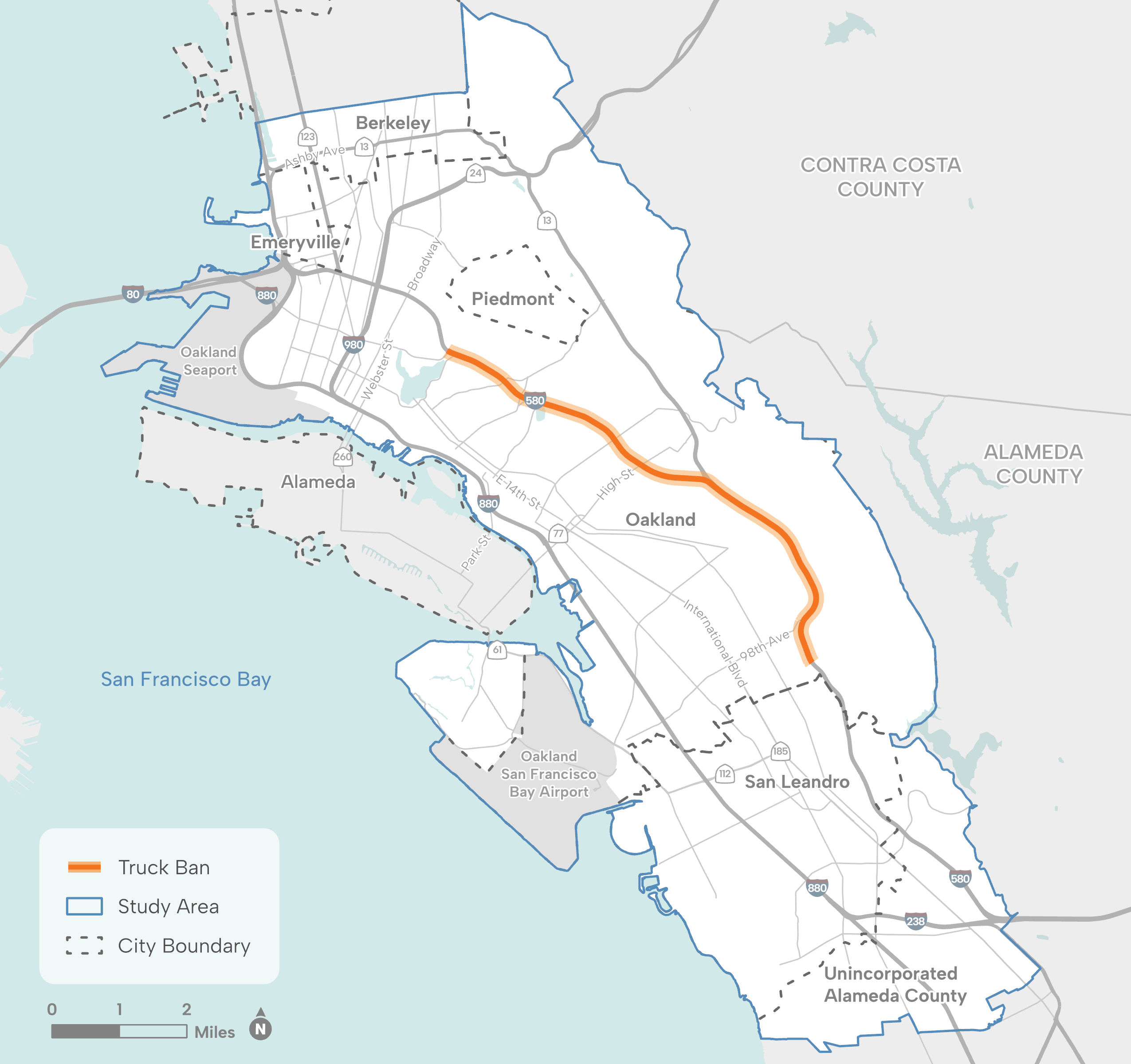
Download or view Interstate 580 Truck Access Study Map
What is the Interstate 580 Truck Access Study?
The Department of Transportation (Caltrans), District 4 is conducting the Interstate (I) 580 Truck Access Study (TAS) to understand how removing the truck ban on I-580 could affect safety, travel patterns, traffic conditions, air quality, and noise along the I-880 and I-580 corridors and other nearby state highways and major arterials. The study will evaluate how exposure to air and noise pollution could change for nearby communities if the truck ban is removed.
This study will create an opportunity to better understand how and why trucks travel through the study area, and identify strategies that could help alleviate disproportionate health impacts from truck traffic experienced by communities within the study area.
Project Study Area
The I-580 corridor in Alameda County begins at the I-205/I-580 Interchange and runs west through the cities of Livermore, Pleasanton, Dublin, San Leandro, Oakland, Emeryville, Albany, and Berkeley as well as unincorporated Alameda County communities of Castro Valley, Ashland, and Cherryland.
The I-880 corridor in Alameda County begins in the City of Oakland and runs south through the cities of San Leandro, Hayward, Union City, Newark, and Fremont as well as the unincorporated Alameda County community of San Lorenzo.
The I-580 truck ban, which prohibits trucks weighing over 4.5 tons (9,000 pounds), begins at Foothill Boulevard in San Leandro and ends at Grand Avenue in Oakland. Exceptions for passenger buses and paratransit vehicles are permitted.
For more information, please see the I-580 Truck Access Study Map.
Project Goals
The study has multiple goals, including:
- Identify and analyze the likely impacts of removing the truck ban from various vantage points.
- Reevaluate the purpose of the truck ban and find consensus for the ban’s future.
- Recommend strategies to address existing issues and inefficiencies in freight flows and alleviate the disproportionate health impact of truck traffic on vulnerable communities.
Interstate 580 Truck Ban History / Timeline
The truck ban, originally implemented along MacArthur Boulevard in Oakland in the 1950’s, was approved when the I-580 freeway was constructed in the early 1960’s. While removing the ban has been proposed several times over the years, this will be the first time a study will be conducted to address this possibility. Click here to review the history of the truck ban or view the timeline below that illustrates the history of how the truck ban came to be.

Download or view Interstate 580 Truck Ban History / Timeline chart
The I-580 Truck Access Study features four components to guide the development of a comprehensive planning study, which will include transportation, health, environmental justice, and equity considerations relating to the ban on heavy trucks along I-580 through Oakland. The four components include:
- Traffic Studies for I-580 and I-880 corridors – The study will examine current traffic patterns and the impacts a repeal of the ban would have on future traffic patterns. The study will look at how traffic will shift for freeways and local roadways within the study area and how the performance of all vehicle types on those facilities will change. The traffic analysis will help to develop recommended strategies.
- Racial Equity Assessment – The study will include an equity assessment of race and historical disparities that will help to inform the development of the final study report and its conclusions and recommendations. The assessment will be analyzed with the I-580 truck ban in place and a scenario without the ban.
- Comprehensive Community Engagement Strategy. A Community Engagement Strategy will be developed that aims to effectively target the communities most impacted by the truck ban, focusing on areas in East Oakland, West Oakland, San Leandro, and unincorporated Alameda County. Outreach and engagement activities will then be conducted to ensure that the voices and opinions of these communities regarding the truck ban are heard and incorporated into the recommended strategies produced in the study.
- Health Assessments (noise and air quality). In collaboration with the Bay Area Air District, the study will develop an air pollution emissions estimate to assess which communities and demographics are overexposed and impacted by air quality issues, caused by proximity to the freeway. The noise impact assessment will be conducted by the hired consultant.
FAQ's
- What is the I-580 Truck Access Study?
Answer: Caltrans, in partnership with the Bay Area Air District and the City of Oakland, are conducting a study to understand how removing the truck ban on I-580 could affect safety, travel patterns, traffic conditions, air quality, and noise along the I-880 and I-580 corridors and other nearby state highways and major arterials. - Will the I-580 truck ban be removed as a result of this study?
Answer: No, this is only a study to help understand what would happen if the truck weight restriction was removed. Caltrans does not have the authority to remove the ban. An act of State legislation would be required to remove the restriction from the California Vehicle Code. - Where is the truck ban in effect?
Answer: An 8.7-mile segment on I-580 between Grand Avenue in Oakland and Foothill Boulevard in San Leandro. - What are the I-580 Truck Access Study limits?
Answer: On I-580, near the unincorporated communities of Ashland and Cherryland to I-80 in Oakland and on I880, from I-238 in San Leandro to I-80 in Oakland. Other State highways and major local arterials within the study area are also included. - Why is the I-580 Truck Access Study being conducted now?
Answer: Caltrans is responding to community concerns and implementing strategies recommended by the West Oakland Community Action Plan (2019) and the East Oakland Mobility Action Plan (2021) to help improve community health. - How long will the I-580 Truck Access Study take to be completed?
Answer: Approximately 18 to 24 months. The final report will be completed in late 2026/early 2027. - Where can I get more information on the I-580 Truck Access Study?
Answer: Email: 04580tas@publicinput.com
Website: publicinput.com/04580tas
Downloadable Resources
- I-580 Truck Town Hall Meeting
- Legal Basis for Truck Restrictions
- California Air and Resources Board Freight & Goods Movement Webpage
- Trucks are Banned on Oakland's I-580. These Sixth Graders Wondered Why | KQED
- Heavy trucks are barred from I-580. Is it time to rethink the 70-year-old restriction?
- Oakland residents weigh in on pros and cons of I-580 truck ban
- Why Keep I-580 Truck Free?. Oakland has been struck with an… | by Ken D. | Our Oakland Magazine | Medium
- A Tale of Two Freeways
- Polluted communities hold their breath as companies struggle with California’s diesel truck ban
- I-580 TAS Story Map: I-580 Truck Access Study
Downloadable Resources
- I-580 Truck Access Study Community Meeting Flyer
This project study is a collaboration between various agencies, each contributing their specialized knowledge and skills to ensure meaningful outcomes.
- Caltrans District 4 Transportation Planning
- Bay Area Air District
- City of Oakland
- Fehr & Peers - Project Consultant
State and Regional Partners
County Partners
 |
|
City Partners
Community Based Organization Partners
Industry Partners
Project Media Bar
Additional project resources including downloadable maps, image galleries, and video clips can be found on the media resources page.
Get Involved / Contact Us
Please visit this webpage to stay updated of the progress of the study and upcoming opportunities to provide feedback on the study.
We also invite you to sign up for our email list here to provide feedback and learn more about upcoming study activities.
If you have questions about the I-580 TAS, please contact the study team:
at 04580tas@publicinput.com