
Caltrans, State Push Fire-Resilient Roadways Strategy
Aggressive vegetation management lowers danger along vulnerable routes
With the memory of California’s most destructive fire season still vivid and the threat of a 2022 repeat lurking, Caltrans is continuing to improve its vegetation management practices to reduce the risk of fire for travelers and communities along roadways that face wildfire danger.
The department’s fire-resilient strategy has a reinvigorated vegetation management planning process at its core. Caltrans refined its process in a series of winter workshops with local fire officials and other stakeholders to share insight and strategies on adapting to wildfire risk within state highway right of way.
The winter workshop series began in the San Francisco Bay Area to identify where to expand Caltrans’ vegetation management program in the East Bay, a drier microclimate hosting forests and grasslands amid a highly urban setting. The workshops addressed requests by the area’s fire chiefs to exchange knowledge about changing weather conditions, combustible fuels buildup, and the probability of wildfire ignition along key highway corridors that could be evacuation routes during large wildfires.
The model highway roadside adapted to wildfire risk will have a more open appearance, with broader spacing between individual mature trees, acres of thinned brush with an understory of new growth shaded by the overhead canopy. Achieving this roadside prescription, where it can be adapted, will not supersede state and federal environmental laws or Caltrans’ other roadway responsibilities.
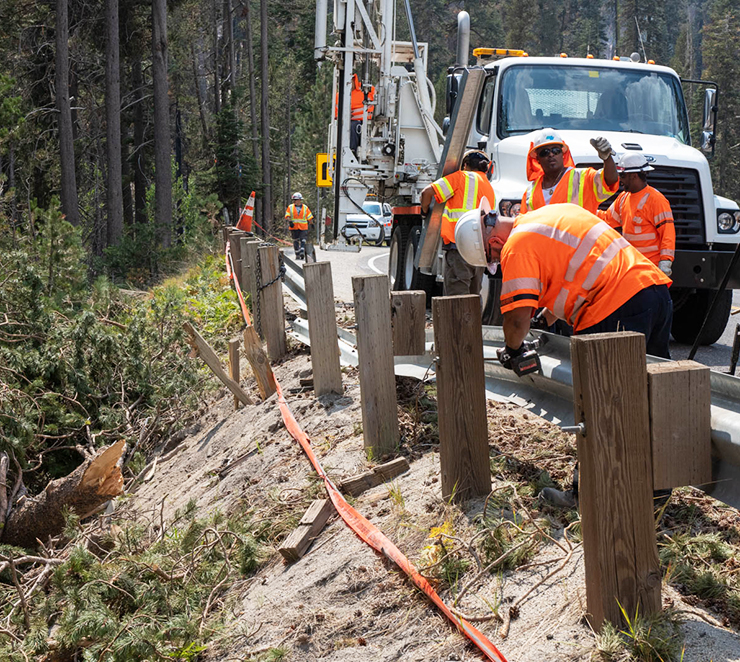
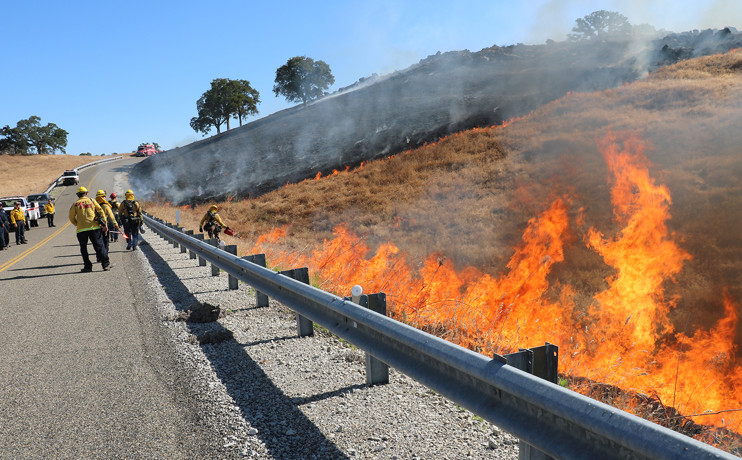
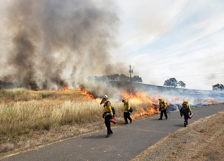
To reduce the risk of wildfire ignition, Caltrans has stepped up herbicide, mowing and brush removal schedules to maintain low-growth strips up to 10 feet wide, depending on the setting. In grassland areas that are inaccessible or too expansive for regular mowing, CalFire recommends controlled burns as a cost-effective treatment to contain regrowth. (Caltrans does not perform these burns. CalFire is responsible for fire prevention measures.)
Starting with District 4, all 12 regional districts held workshops by the end of March 2022 in preparation for another hot, dry summer.
More aggressive vegetation management policy
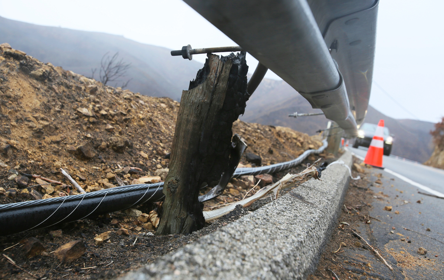
Caltrans has long practiced vegetation control of weeds and grasses along the edges of state highways to ensure drivers have an unobstructed view of guardrail, signs, barriers and lane striping. In the last several years, however, as climate change has begun to grip California with extreme droughts and disastrous wildfires, Caltrans re-examined its historic vegetation control practices and embarked on a more comprehensive and aggressive fuels reduction strategy to reduce wildfire ignition probability and establish shaded fuel breaks along travel routes it maintains.
Caltrans also is supporting a broader Fire-Safe Roadways campaign, joining other local, state and federal agencies in Governor Gavin Newsom’s California Wildfire and Forest Resilience Task Force. Amid changing climate conditions in the state that help spawn larger, more destructive fires, the task force is countering with a strategy to build the resilience of the natural environment along roadways. As a result of the task force, Caltrans is aligned to receive technical insight from CalFire, the U.S. Forest Service, tribal representatives and local fire officials who practice fire prevention and natural resource management.
The task force released the California Wildfire and Forest Resilience Action Plan in January 2021. The comprehensive report establishes a series of goals to protect communities and forests from fire, and assigns participating entities, including Caltrans, to work on a 100-point action plan to reduce fire fuels buildup in California.
Caltrans Fire Role
Modernizing roadside vegetation control
As the state’s fire prevention efforts progress, Caltrans’ HQ Maintenance Office of Vegetation and Wildfire Management partnered with District 4’s Division of Maintenance on modernizing its roadside management of natural vegetation within the right of way.
Intended as a pilot project to inform Caltrans’ statewide efforts, the East Bay Vegetation Management Plan identifies high-priority roadside locations within the state highway network in Alameda, Contra Costa, Marin and Santa Clara counties for additional fuels reduction. Working in partnership with local, state and elected officials, Caltrans is augmenting in-house vegetation control with contracts for more extensive clearing services along seven key highway corridors in the four Bay Area counties, totaling 59 centerline miles of comprehensive vegetation management.
The conditions along those corridors will determine the type of vegetation treatment and width of the buffer needed to mitigate fire risk to the traveling public, adjacent communities and Caltrans personnel, according to the East Bay plan.
Caltrans completed one major fuels reduction project in the area last year along State Route 17 in Santa Clara County as part of a statewide effort by CalFire to reduce fire loads on key corridors. More larger-scale projects are planned for this fiscal year. Caltrans is seeking bids on seven major fuel reduction contracts, part of the $31 million that the department is devoting to lessening fire danger on critical state routes.
In all, there is funding for contracts that will reduce fuels buildup on more than 500 lane-miles of state highway within two years. Federal infrastructure funds could further expand Caltrans’ fuels reduction campaign in the 2022-23 fiscal year.
Other Caltrans regional districts are scheduled to use the District 4 vegetation management framework to draft their own fuels reduction strategy, and overlay the conditions particular to their area, proposed actions and a time frame into that template.
Analysis reveals fire risk to state routes
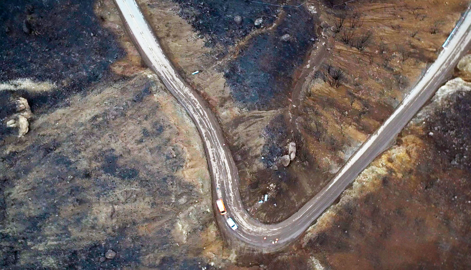
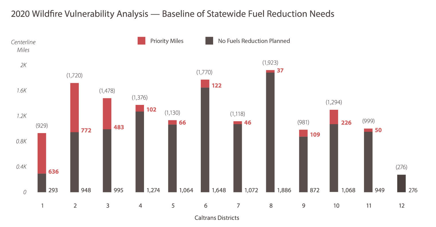
A Caltrans Wildfire Vulnerability Analysis prepared in 2019 and repeated in 2020 confirmed that a significant portion of the state highway network is vulnerable to wildfire.
The research by the University of California, Davis, and an environmental consultant mapped state highways in all 12 Caltrans districts in one-mile segments. The analysis, using geographic information system mapping software, applied 20 different risk factors, including population, resources and emergency capacity, to determine each highway section’s risk profile.
The four-month study, which was duplicated the following year to confirm the findings, found that more than 2,600 centerline miles of state highway, 17.3% of the 14,993 total centerline miles in the state, need some degree of fuels reduction effort. (Centerline miles are measured by road distance and don’t take multiple lanes into account.)
Highways in Caltrans districts in the northernmost parts of the state faced the most danger, the analysis found, while districts in the more arid south state had fewer state travel routes at risk. District 4, with an expanse of drier, inland wooded areas alongside population centers, has 102 centerline miles needing fuels clearance, about 7 percent of state highway miles within the nine-county Bay Area district.
The need for a new level of vegetation control has been identified by Caltrans climate studies that predict hotter temperatures and changing precipitation patterns in California through this century will result in drier forests and foothills — raising the likelihood of catastrophic fires.
Million-acre fuels reduction plan
The state task force’s work dovetails with Caltrans’ involvement in Gov. Newsom’s $1.5 billion wildfire and forest resilience program, part of a $15 billion-plus climate package announced by the governor in September 2020. The 100 assignments in the Wildfire and Forest Resilience Action Plan support the ultimate goal of expanding fire fuels treatment in California forestlands to one million acres annually by 2025.
Caltrans is taking the lead on six action items on behalf of a Fire-Safe Roadways goal in the 100-point state plan:
- Identify subdivision secondary emergency access.
- Develop a framework to create road corridors less susceptible to fire.
- Assist with area government’s general plans.
- Expand highway treatments.
- Develop good neighbor agreements.
- Expand a messaging campaign.
Caltrans also established a Vegetation and Wildfire Executive Steering Committee in August 2021 in support of the action plan. The executive committee’s intent is to coordinate a shift in Caltrans’ vegetation management practices that is inclusive of external fire agency expertise, updates policy, implements new workflow processes and shares best practices.
Forest thinning projects represent another fuels reduction strategy for Caltrans along state highways, in cooperation with CalFire, U.S. Forest Service and local entities. Since 2015, Caltrans and its contractors have removed nearly 180,000 dead or dying trees that posed a threat of interfering with or obstructing travel along state highways. Many of those fallen trees, part of a massive die-off caused by prolonged drought or bark beetle infestations, were fed into biomass plants that generated enough electricity to power more than 21,000 California homes in one year.
With its expanded vegetation management practices, increased fuels reduction funding, and partnerships to leverage projects with local and state fire agencies, Caltrans’ maintenance operations help make our roadways more fire-resilient, one post-mile at a time.
Source: Caltrans Division of Maintenance; Office of Vegetation and Wildfire Management
Mile Marker: A Caltrans Performance Report, Issue 1, 2022
- Director's Message
- Mile Markers
- Caltrans, State Push Fire-Resilient Roadways Strategy
- Projects Honor, Protect a Way of Life
- All Aboard to the Future
- Caltrans Helps Make Clean Sweep of State
- More Federal Dollars Strengthen State Travel Grid
- Project Spotlight: Otay Mesa East
- Pavement Innovations Will Have a Lasting Impact
- All-in-one version