
In 1911, California’s highway system was divided into seven regional districts. Thirteen years later, three more districts were created. Today, there are 12. Photo Courtesy of the Caltrans Library and History Center 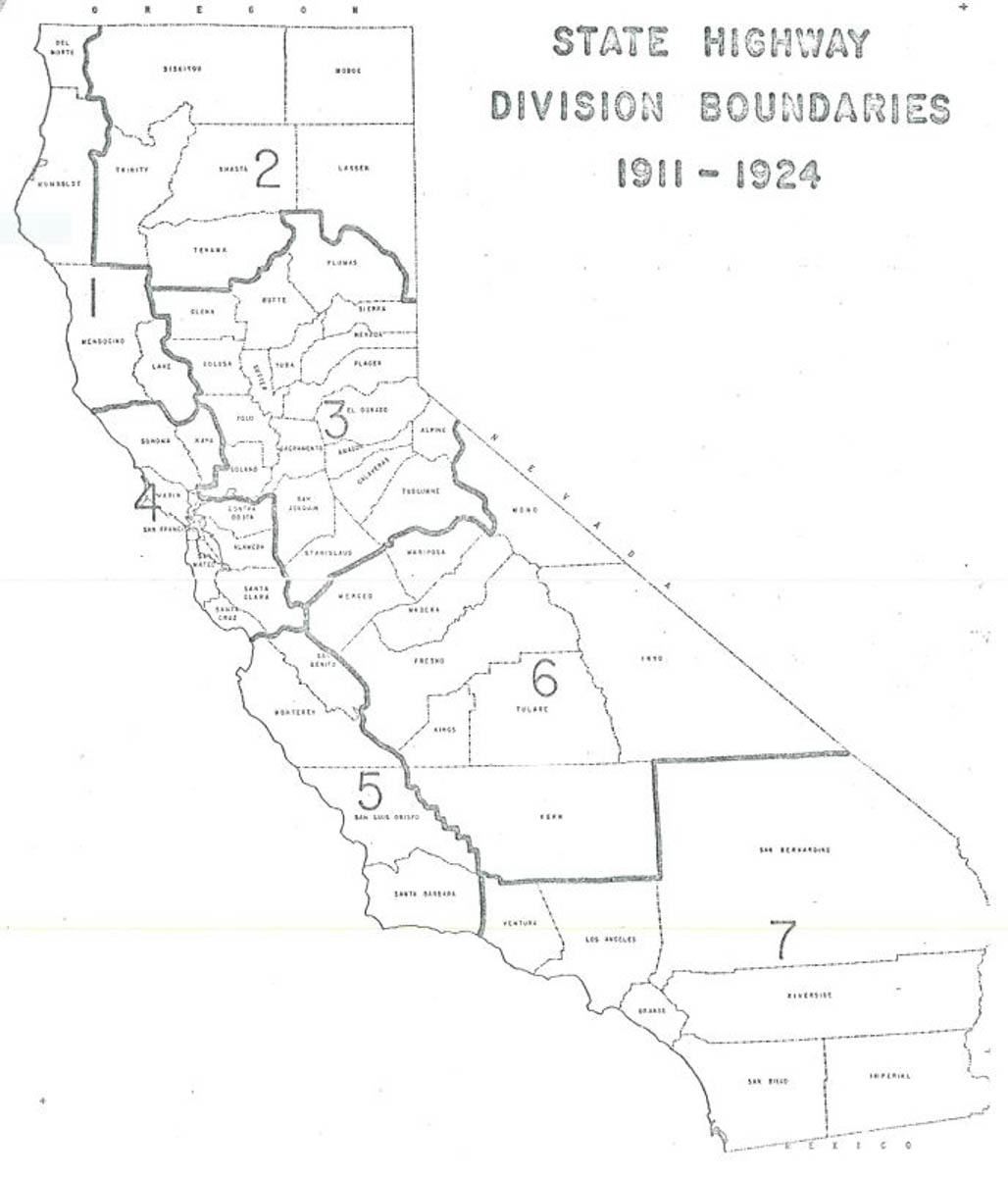
Note: This is the first in an occasional series of CT News stories that explore the century-plus history of the department and California’s highway system.
Recently we were asked how Caltrans’ 12 district boundaries came about. That led us to the library at Caltrans Headquarters, and down a scenic path of historical tidbits.
Buckle up for a 110-year ride.
The birth of the state highway system was on March 22, 1909, when the Legislature approved the State Highway Act, and in November 1910 voters approved an $18 million bond issue for land acquisition and road construction.
In August 1911, a day after the three-member California Highway Commission was established, Gov. Hiram Johnson appointed Austin B. Fletcher to head the commission as State Highway Engineer. The commission divided the burgeoning highway system into seven “divisions.” (That reference changed to “districts” in 1927.)
A history of Caltrans district boundaries that was written in 1971 recounts the process to create the original boundaries.
“A large corps of engineers and assistants was assembled to make surveys, estimates, etc., for the work,” the 1971 memorandum reads. “… There is no statement available concerning the reasoning behind the locations of the division boundaries, but it is apparent that they were created for administrative reasons primarily to divide the planning and construction work somewhat uniformly, taking geographic barriers of the state into account.
“There was probably no consideration given to maintenance problems, since maintenance of state highways was handled by the local jurisdictions at that time. The division boundaries did not bisect any counties, as do the modern district boundaries.”
In 1924 the state addressed the highway system’s rapidly evolving needs by carving out three new divisions. The 1971 memorandum summarizes:
“The stated reasons for further rearrangement of the division boundaries were traffic growth, increase of mileage of constructed highways, and additional maintenance requirements. Also, the special problems encountered in the coast counties from Ventura to San Diego required special and concentrated treatments which were totally dissimilar from the problems of the desert.
“This was the first time that counties had been split by division boundaries.”
Over the years, counties occasionally were bisected or even trisected by Caltrans divisions/districts. Today, only Kern County is divided—Districts 6 and 9 each oversees a portion.
By 1933, statutes had increased the mileage of the State Highway System from 7,350 to 14,150. Again, the 1971 memorandum elaborates:
“This sudden doubling of state road mileage required a readjustment of district boundaries and considerable shifting of personnel. The most drastic change was in Southern California, where it was found necessary to establish an additional district, bringing the total to 11.” Also in 1933, the District 3 office was moved to Marysville, and the District 10 office to Stockton; both had been in Sacramento.
The next and to date the last district debut was in April 1987, when Gov. George Deukmejian announced the establishment of a fully functioning District 12 office in Orange County, thereby removing Orange County highway operations from District 7.
The overriding explanation of why the number of districts has grown and their boundaries have been adjusted is that those changes are geared toward improving efficiency. Many of the highway construction and maintenance challenges encountered along the Central Coast (District 5) are different from those encountered in major metropolises (Districts 4 and 7), vast desert regions (District 8), the Sierra (Districts 6 and 10), and so forth.
The districts as drawn now reflect a categorization of specific needs, a geographical spacing out of district offices and a balance of the overall Caltrans workload.
Are you curious about some aspect of Caltrans’ history that you think would make a good candidate for this series? Please email your idea(s) to Reed.Parsell@dot.ca.gov.