
Connected and Automated Vehicle Projects
Connected and Automated Vehicle (CAV) technology has the potential to provide greater mobility for all people, improve roadway efficiency, increase California's economic competitiveness, and make our environment and people healthier.
 Route: SR 82 (El Camino Real) in Santa Clara County
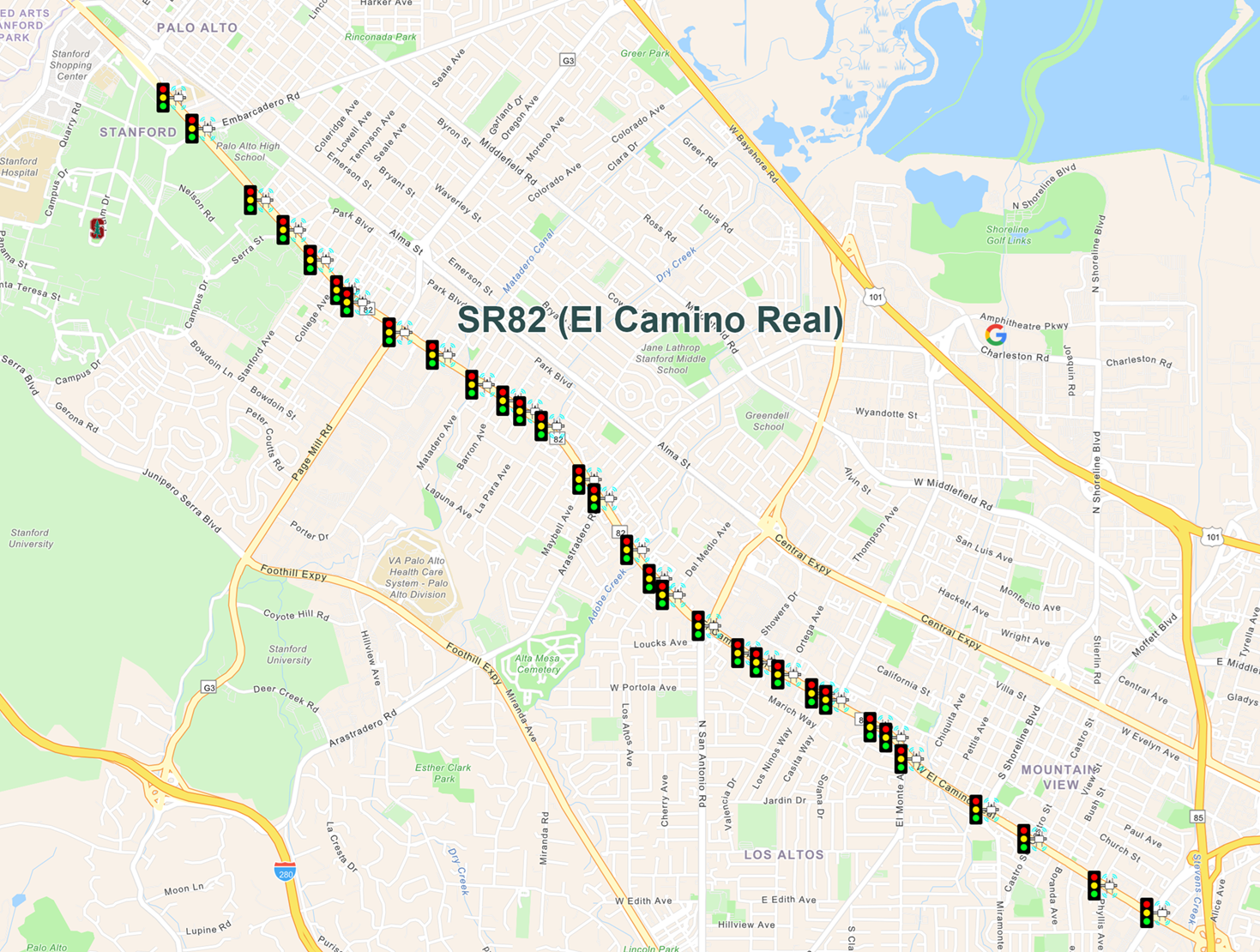
Deployment Length: 7 miles
Equipment:
- 16 Dedicated Short-Range Communications (DSRC) Roadside Units (RSUs) [Project underway to upgrade the DSRC RU with C-V2X RSUs]
- 15 C-V2X RSUs
The El Camino Real CAV Corridor spans seven miles along State Route 82, from Stanford University in Palo Alto to State Route 85 in Mountain View. It features 31 consecutive intersections equipped with Connected Vehicle infrastructure, exchanging data with Caltrans 2070 traffic controllers at each intersection to populate Signal Phase and Timing (SPaT) messages and manage adaptive signal and priority timing.
The corridor was originally established in 2005 as the California Connected Vehicle Test Bed. It began as a partnership between Caltrans, the Metropolitan Transportation Commission (MTC), and UC Berkley Partners for Advanced Transit and Highways (PATH), and was the nation's first public Connected Vehicle Test Bed. It is now operated and maintained as an operational CAV deployment by Caltrans District 4 with support from PATH.
Additional information is available at the UC Berkeley CAV Test Bed website.
Developed, Tested and Deployed CAV Services (Deployed = D, Tested = T):
| CAV Services | Deployed | Tested |
| MMITSS | X | |
| Communication based actuation for pedestrians, bicyclists, and vehicles | X | |
| SAE J2735-201 603 message library | X | |
| Intersection geometry map | X | |
| SPaT | X | |
| Signal status message (SSM) | X | |
| Basic safety message (BSM) | X | |
| Signal request message (SRM) | X | |
| RTCM corrections message | X | |
| Eco-approach and departure (EAD) | X | |
| Red light violation warning | X |
CAV Services Under Development:
- Cloud and V2X hybrid transit signal priority (TSP)
- Transit EAD application integrated with TSP
- Bike signal priority
- Traffic signal controller with dual processors for V2X deployment
- Reduced speed zone/lane closure warning
- Signalized pedestrian crosswalk alert
- Mid-block pedestrian crosswalk alert
- Pedestrian crosswalk alert near HAWK (High-Intensity Activated Crosswalk) signals
- Advanced work zone priority
 Routes: Route 5, 8, and 15 in San Diego County
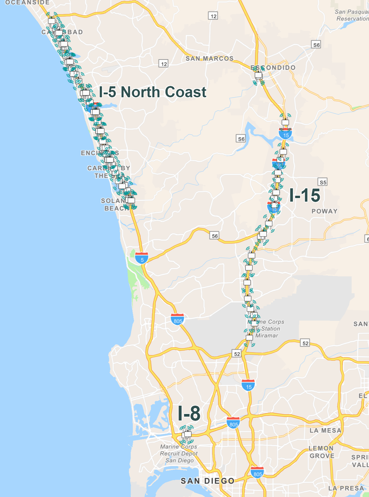
Total Deployment Length: 33 miles
Equipment: 21 RSUs along Route 15, 55 along I-5, and 2 along I-8
District 11 has two major RSU deployments north of San Diego:
- 14 miles of I-5 North Coast from Solana Beach to South Oceanside, featuring 21 C-V2X RSUs.
- 20 miles of I-15 from Miramar to Escondido, featuring 55 C-V2X RSUs.
These RSUs will receive Basic Safety Messages (BSMs) from vehicles and broadcast Traveler Information Messages (TIMs) and safety warnings. Additional CAV use cases will be deployed, including:
- Expanded CMS
- Queue warning
- Upcoming work zone warnings
- SPaT
- BSMs
- Wrong way driving
Aside from these major deployments, District 11 has also been engaged in pilot projects:
Bus on Shoulder Pilot Project
The project was a partnership with the San Diego Association of Governments, California Department of Transportation District 11, San Diego Metropolitan Transit System, California Highway Patrol, Federal Transit Administration, and the U.S. Department of Transportation Federal Highway Administration and concluded in 2025.
RSUs were installed on Route 805 at eight ramp meter locations. OBUs installed on 15 MTS buses provide audio and visual alerts to the bus operators as the bus approaches a metered on-ramp. The OBU communicates with an RSU connected to the ramp meter's controller providing timing information and stopping the traffic at on-ramps thus making transit priority as the bus approaches the metered on-ramp along the right shoulder of the mainline.
Connected Vehicle Enabled Intersection Pilot Project
The RSU mounted to the luminaire mast arm of the traffic signal standard at the EB on-ramp to Route 8 collects BSMs while providing SPaT messages to vehicles equipped with OBUs. The BSMs are stored in the roadside equipment in the traffic signal controller cabinet.
 Routes: 5, 22, 55, 57, 91 and 405 and at Caltrans ramp intersections along Routes 5, 57, and 91 in Orange County
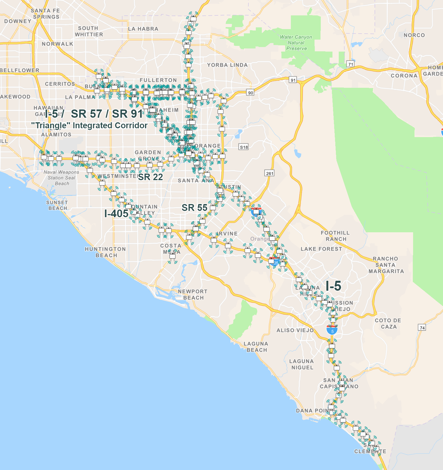
Total Deployment Length:115 miles
Equipment: 188 RSUs and RSE along mainline Routes 5, 22, 55, 57, 91 and 405 and at ramp intersections along Routes 5, 57, and 91
The District 12 CAV Project will also be integrated with the Triangle Integrated Corridor Management (ICM) project and will be used as part of the proposed ICM strategies in response to major incidents.
Freeway Connected Vehicle Component - The purpose is to enhance the operations of the freeways in Orange County. It is envisioned that information captured from connected vehicles will improve the TMC's situational awareness and provide travelers with real time traffic conditions and safety alerts.
Arterial Connected Vehicle Component - There are several congested intersections in the ICM project area. The connected vehicle infrastructure will improve the safety of pedestrians and the mobility of public and emergency vehicles. On-ramps and off-ramps will be managed better when connected vehicles can be targeted for route diversion.
Planned CAV Services to be Deployed along Freeways:
- Traveler information messages (TIM)
- Event and work zone warning
- End of Queue warning
- Wrong way driver warning
Planned CAV Services to be Deployed along Intersections:
- Red light violation warning
- Reduced speed/work zone warning
- Pedestrians and bicycles in signalized x-walk warning
- Transit signal priority
- TIM
Accurate lane-level positioning is essential for many CV applications, but typical GNSS/GPS receivers can only provide accuracy up to 5 meters.
Real-Time Kinematic (RTK) positioning can correct GPS errors and provide up to centimeter-level accuracy and is widely used in surveying. The Radio Technical Commission for Maritime (RTCM) protocol defines how correction data is transmitted, and the SAE J2735 standard allows these corrections to be broadcast directly from roadside units (RSUs) to vehicles via C-V2X communications.
To enable this position correction communication for RSUs in Caltrans, the California Partners for Advanced Transit and Highways (PATH) developed a platform to:
- Deploy an operational RTCM system at the District 12 Traffic Management Center (TMC) to broadcast correction messages from RSUs.
- Create a secure website for authorized Caltrans staff to register and manage RSUs within the RTCM system.
152 RSUs are currently registered with the Southern California RTCM system to receive RTCM correction messages. A similar deployment is in progress for Northern California.
For Caltrans staff, visit the SoCal RTCM website and the User Guide.
