
Orange skies and gray smoke are a disorienting and frightening backdrop to this roadway in Southern California. Photo by Steve Wells, District 7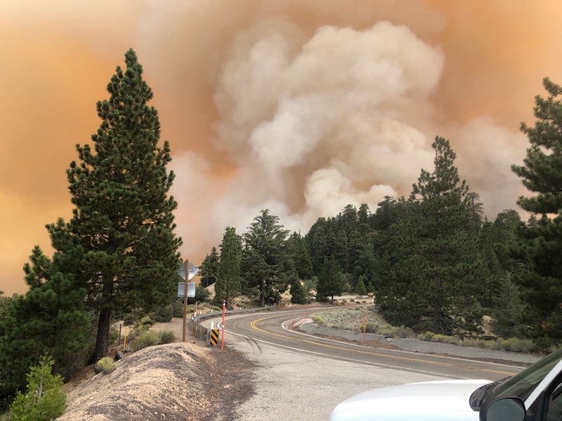
By Marc Bischoff
Public information officer, District 7
The 2020 brush fire season so far: California forests burst into flames with more than 3 million acres burned. Six of the largest brush fires in California recorded history. All 18 California National Forests closed to recreation. Seventeen counties in a state of emergency.
In Caltrans District 7 (Los Angeles and Ventura counties), several brush fires burned through the Angeles National Forest on the north side of Los Angeles County, including the Dam (220 acres), Ranch 2 (4,237 acres), Lake (31,089 Acres), and Bobcat (over 50,000 acres and still uncontained) fires.
The Ranch Fire erupted shortly after 3 p.m. on Aug. 13 along State Route 39 (SR-39) on the north end of the city of Azusa, at the intersection of San Gabriel Canyon Road and North Ranch Road. Caltrans District 7 Maintenance closed SR-39 in both directions at that location. Once the south end of the fire was secured from moving down into the city of Azusa, the points of closure were set between the San Gabriel River Bridge (post mile 17.7) and East Fork Road (post mile 25.7).
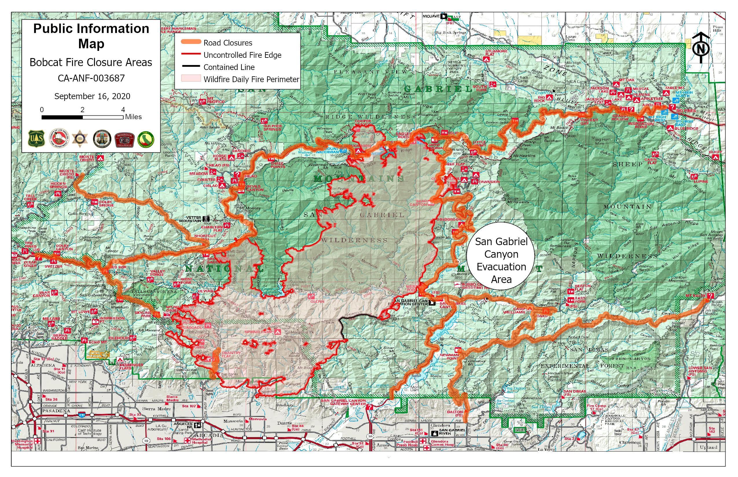
Click on this map to get an overview of the major fires in Los Angeles and Ventura counties.
Map by District 7
The wildfire continued to move quickly northward as rugged and steep terrain, dry chaparral and hot days created challenges for the fire crews. When the fire battle moved farther into the forest, it was re-designated as the Ranch2 Fire.
SR-39 through the Angeles National Forest is a popular recreational destination for Southern California residents year-round, the only route leading to multiple campgrounds and lakes. The SR-39 closure remained in place until 8:30 a.m. Aug. 27, with Caltrans Maintenance crews bulldozing the roadway to keep it clear for fire crews. The fire was declared contained at midnight on Aug. 28, with a final size of 4,237 acres burned and 96 percent contained as of Sept. 14. The suspected cause is arson.
At approximately 12:21 p.m. on Sept. 6, the Bobcat Fire started near the Cogswell Dam and West Fork Picnic Area and Bridge in the Angeles National Forest, forcing another closure of SR-39. This wildfire raged to the west of SR-39 and south of State Route 2 (SR-2), another significant mountain roadway traversing east/west through the Angeles National Forest. It has burned quickly and mostly out of control since inception. A Unified Command was established including the Angeles National Forest, Los Angeles County Fire Department, Los Angeles County Sheriff’s Office, cooperating fire departments, foothill cities, and Caltrans.
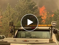
Caltrans was on the scene to help out when a fire raged near the junction of State Routes 2 and 39.
Video by District 7
Caltrans Maintenance quickly established a closure on SR-39 from Old San Gabriel Canyon Road on the south end all the way through the length of the route in the forest. It has remained in place for the duration of the fire battle.
About 7 a.m. on Sept. 7, SR-2 was closed between Big Tujunga Canyon Road and Mount Wilson Red Box Road in the Angeles National Forest due to the fire. Over time, the SR-2 closure was eventually expanded to Angeles Forest Highway on the west end of the forest in District 7 across SR-39 to the mountain community of Big Pines, near the San Bernardino County line. The east end of the SR-2 closure has been maintained by Caltrans District 8.
Sept. 7 was also the day the Caltrans District 7 Chilao Maintenance Station located along SR-2 was evacuated pre-emptively. Ten Caltrans staff, with a total of four families, are staying in hotels or with family and friends. This is a year-round live-in community with cabins and barns. Crews are working out of the Altadena Maintenance Station along I-210 just west of Pasadena. All equipment was moved into a brick barn with a metal roof.
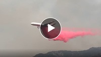
Click on the image to watch a jetliner drop fire retardant on Mount Wilson in Los Angeles County.
Video by Andrew Mitchell, Firenet365
By Sept. 8, fire authorities were already alerting communities on the south end of the wildfire to prepare for possible mass evacuations. On Sept. 9, the Bobcat Fire crossed east over SR- 39 toward Crystal Lake and voluntary evacuations were implemented in the city of Monrovia. By Sept. 10, evacuation warnings were in effect for the cities of Monrovia, Arcadia, Bradbury, Sierra Madre, Altadena, Duarte and Pasadena. By Sept. 15, evacuation orders had been issued for segments of the cities of Arcadia and Sierra Madre. By Sept. 17, evacuation warnings were in effect for parts of the southern Antelope Valley.
Caltrans District 7 currently has three crews on duty 24/7 staffing the hard closures on SR-2 and SR-39 with trucks keeping the mountain roads clear of rocks and other debris for emergency crews and for the safety of the frightened wildlife. The entire fire area is a no-fly zone for private drones.
As of Sept. 15, the Bobcat Fire became an imminent threat to the famed Mount Wilson Observatory, coming within 500 feet. The fire has contributed to the current substantial smoke pollution across Southern California. As of Sept. 17 the estimated number of total acres burned in the fire was 50,539 with only 3 percent of the perimeter contained. Full containment is not expected until Oct. 30. The cause of the fire is still under investigation.