
Scenic Route 68 Corridor Improvements Project
Project Description
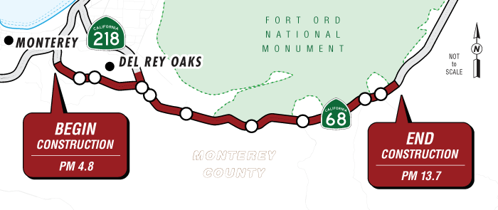
The California Department of Transportation (Caltrans) is proposing to improve traffic operations and reduce collisions with wildlife on an approximately nine-mile stretch of State Route 68 in Monterey County by modifying the design of nine intersections from Josselyn Canyon Road to San Benancio Road and by providing five new underground culverts for wildlife to use to cross under the highway. The proposed work would extend from highway post mile 4.8 to post mile 13.7 (west to east). Two build alternatives were evaluated in the Project Approval and Environmental Document phase. Alternative 1 would convert nine intersections into roundabouts; five would be converted into single-lane roundabouts, three would be hybrid roundabouts (a combination of one and two traffic lanes around the circle) and one would be converted into a two-lane roundabout. Alternative 2 would include expanded signalized intersections with adaptive signal control technology and enhanced lane channelization to provide auxiliary through lanes and additional right and left turn lanes. Both alternatives would provide improved bicycle and pedestrian facilities and replacement lighting where necessary. Both alternatives would replace drainage facilities and utilities that would necessitate relocation due to the intersection modifications. Temporary construction easements would be required for access to nearby properties for construction activities where necessary.
After circulation of the draft environmental document for public review, Caltrans responded to public comments and prepared a final environmental document. Caltrans selected Alternative 1 as the preferred alternative for final design. The final environmental document is available via a link provided in the Documents section below.
Project Benefits
Purpose
The purpose of the project is to improve intersection operations to reduce vehicle delays throughout the project corridor and reduce the rate and severity of collisions in the project area. The project also proposes to enhance wildlife connectivity, reduce the rate of collisions between vehicles and wildlife, and improve bicycle and pedestrian access within the project section of State Route 68.
Need
The State Route 68 corridor experiences heavy congestion, causing travel delays, which mostly occur at signalized intersections. Daily travel delays are predicted to nearly triple by the year 2045 with the existing intersection traffic controls and lane configurations. Traffic delays at intersections are caused, in part, by the inefficiency of the existing intersection signal controls, which have limited green time for each direction of travel, and a lack of coordinated signal timing among the intersections. Lines of backed-up vehicles (queuing) occur during peak traffic periods during the morning and late afternoon-early evening when vehicles cannot move through the intersections during the first green light phase of the signals. Queuing results in delays along the project corridor through stop-and-go traffic conditions at multiple intersections and often blocks access to driveways and side streets that intersect State Route 68. The project corridor has several segments with collision rates above the statewide average for similar facilities. Rear-end collisions are the most common collision types occurring within the project area and are typically associated with congestion or stop-and-go traffic conditions during peak periods. State Route 68 intersects a critical wildlife habitat area connecting the coast of Monterey to the Sierra Azul range. As such, the vehicle traffic on State Route 68 routinely comes in conflict with wildlife trying to cross the highway, resulting in roadkill, property damage, and vehicle safety issues. In addition, State Route 68 needs pedestrian and bicycle refuge areas, sidewalks, and marked bicycle lanes to reduce delays for bicyclists and vehicles at intersections.
Estimated Funding Breakdown
| Funding Source | Funding Amount |
|---|---|
| Local | $50,000,000 |
| State | $3,966,644 (more to be determined) |
| Federal | $29,069,356 (more to be determined) |
| Alternative 1 | $189,200,000 |
| Alternative 2 | $230,900,000 |
Partnerships
Transportation Agency for Monterey County
Proposed Project Schedule
| Process | Date |
|---|---|
| Final Environmental document to be completed | June 2025 |
| Right of way acquisition to be completed | June 2027 |
| Design to be completed | July 2027 |
| Advertise | October 2027 |
| Construction to begin | March 2028 |
| Construction to be completed | November 2030 (subject to construction phasing and funding availability) |
Project Contact
District 5 Public Information Office
Phone: 805-549-3138
Email: info-d5@dot.ca.gov
Documents
Accessibility Assistance: Caltrans makes every attempt to ensure our documents are accessible. Due to variances between assistive technologies, there may be portions of this document which are not accessible. Where documents cannot be made accessible, we are committed to providing alternative access to the content. Should you need additional assistance, please contact us at (916) 654-2852 or visit https://dot.ca.gov/request-ada-compliant-documents.
- Draft Environmental Impact Report/Environmental Assessment and Section 4(f) Evaluation - November 2023 (PDF - 12.9 MB)
- Public Notice (English) - October 2023 (PDF - 198 KB)
- Public Notice (Spanish) - October 2023 (PDF - 198 KB)
- Build Alternative 1 Design Images
- Build Alternative 2 Design Images
- Final Environmental Impact Report/Environmental Assessment with Finding of No Significant Impact
- Notice of Determination
Title VI Information
The California Department of Transportation (Caltrans) assures that no person shall, on the basis of race, color, or national origin, be excluded from participation in, be denied the benefits of, or be otherwise subjected to discrimination under any program or activity receiving Federal financial assistance, as required by Title VI of the Civil Rights Act of 1964, as amended, the Civil Rights Restoration Act of 1987, and Federal Executive Order 12898 (Federal Actions to Address Environmental Justice in Minority Populations and Low-Income Populations).
Caltrans will make every effort to ensure nondiscrimination in all of its programs and activities, whether they are federally funded or not, and that services and benefits are fairly distributed to all people, regardless of race, color, or national origin. In addition, Caltrans will facilitate meaningful participation in the transportation planning process in a nondiscriminatory manner.
Title VI Brochures
Title VI brochures in various languages