
San Lorenzo River Bridge and Kings Creek Bridge Replacement
Project Description
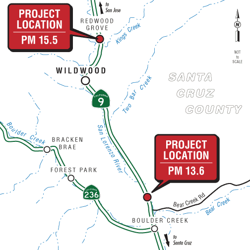
The California Department of Transportation (Caltrans) proposes to replace the San Lorenzo River Bridge (Bridge Number 36-0052) at post mile 13.6 and Kings Creek Bridge (Bridge Number 36-0054) at post mile 15.5 on State Route 9 in Santa Cruz County, in the unincorporated community of Boulder Creek.
The project will remove and replace both bridges with new single-span, standard-width structures consisting of 12-foot-wide lanes and 8-foot-wide outside shoulders. At the San Lorenzo River, the new bridge will be 106 feet long and 40 feet wide and will replace the existing bridge at this location, which is the same length but only 31 feet wide. At Kings Creek, the new bridge will be 99 feet long and 40 feet wide and will replace the existing bridge at this location, which is 88 feet long and 28 feet wide. The existing metal beam guardrail at both bridges will be replaced with standard Midwest Guardrail Systems, which will be connected to each side of the bridges. A taper will be paved on the sides of each bridge to transition the new 8-foot-wide shoulders to the existing roadway shoulders. Work in the streambeds is proposed and will require the use of a temporary diversion system to dewater work areas for demolition and removal of existing bridge abutments and piers. Because the existing abutments at both bridges were constructed by casting materials directly into the exposed bedrock within the stream channel, the abutments will be partially removed in an effort to minimize removal of bedrock and alteration of the stream channel. Abutments and side support columns at the San Lorenzo River Bridge will be removed to the extent required to make space for the new bridge abutments, and therefore will not be removed to original grade. At the Kings Creek Bridge, a portion of existing sacked concrete (0.049 acre), located approximately 10 feet above the Ordinary High Water Mark, along the existing northern abutment, will be replaced with rock slope protection. The existing pier located below the Ordinary High Water Mark will be removed to approximately 3 feet below original grade.
This will result in an increase of about 22 square feet of critical habitat area for special-status fish species at Kings Creek. It is expected that all work will occur within the existing state and County road rights-of-way; no new right-of-way will be necessary. The owner will relocate existing utilities that would conflict with construction operations before and during construction.
The proposed bridges will be built along the existing State Route 9 alignment. State Route 9 is a rural and mountainous highway that stretches 35 miles from State Route 1 in the city of Santa Cruz along the Pacific Coast to State Route 17 in the town of Los Gatos at the southern edge of the greater San Francisco Bay Area. State Route 9 passes through the San Lorenzo Valley and the Saratoga Gap in the Santa Cruz Mountains. The proposed project area is a section of the travel corridor that is in a rural setting surrounded by residential land uses.
The California Department of Transportation (Caltrans) proposes to replace the San Lorenzo River Bridge (Bridge Number 36-0052) at post mile 13.6 and Kings Creek Bridge (Bridge Number 36-0054) at post mile 15.5 on State Route 9 in Santa Cruz County, north of the unincorporated community of Boulder Creek.
Each bridge would be replaced with larger structures to accommodate 12-foot-wide travel lanes and 8-foot-wide shoulders in both directions. At the San Lorenzo River, the new bridge would be 106 feet long and 40 feet wide and would replace the existing bridge at this location, which is the same length but only 31 feet wide. At Kings Creek, the new bridge would be 99 feet long and 40 feet wide and would replace the existing bridge at this location, which is 88 feet long and 28 feet wide. The existing metal beam guardrail at both bridges would be replaced with standard Midwest Guardrail Systems, which would be connected to each side of the bridges. A taper would be paved on the sides of each bridge to transition the new 8-foot-wide shoulders to the existing roadway shoulders. Work in the streambeds is proposed and would require the use of a temporary diversion system to dewater work areas for demolition and removal of existing bridge abutments and piers. Existing bridge piers and their foundations would be removed from Kings Creek. This would result in an increase of about 22 square feet of riparian area, critical habitat for the Central California Coast Coho Salmon and Central California Coast Steelhead, and essential fish habitat for Central California Coast Coho Salmon. It is expected that all work would occur within the existing state right-of-way; no new right-of-way would be necessary. The owner would relocate existing utilities that would conflict with construction operations before and during construction.
The proposed bridges would be built along the existing State Route 9 alignment. State Route 9 is a rural and mountainous highway that stretches 35 miles from State Route 1 in the city of Santa Cruz along the Pacific Coast to State Route 17 in the town of Los Gatos at the southern edge of the greater San Francisco Bay Area. State Route 9 passes through the San Lorenzo Valley and the Saratoga Gap in the Santa Cruz Mountains. The proposed project area is a section of the travel corridor that is in a rural setting surrounded by residential land uses.
Project Benefits
Purpose: The purpose of this project is to address the superstructure and substructure deficiencies of the San Lorenzo River Bridge (Bridge Number 36-0052) and Kings Creek Bridge (Bridge Number 36-0054) to ensure serviceability of State Route 9.
Estimated Funding Breakdown
This project is included in the 2018 Federal Statewide Transportation Improvement Program and is proposed for funding from the State Highway Operation and Protection Program. Additionally, the project is included in the Association of Monterey Bay Area Governments’ 2040 Metropolitan Transportation Plan/Sustainable Communities Strategy and its cost-constrained 2018 Metropolitan Transportation Improvement Program. The project is also listed under the State Highway Operation and Protection Program Grouped Project Listing—Bridge Rehabilitation and Reconstruction. The current capital construction cost estimate (not escalated) for the Build Alternative is $14,251,500. The current right-of-way cost (not escalated) is $32,500. The expected construction funding year is 2021/2022.
- State: $1,634,590
- Federal: $12,616,410
- Construction Cost: $14,251,000
Proposed Project Schedule
- Final environmental completed: February 2021
- Right-of-way acquisition completed: May 2024
- Design completed: September 2024
- Advertise: April 2025
- Construction to begin: August 2025
- Construction to be completed: March 2028
Contact
Matt Fowler, Environmental Senior
Phone: (805) 542-4603
Email: matt.c.fowler@dot.ca.gov
Kelli Hill, Project Manager
Phone: (805) 458-3162
Email: kelli.hill@dot.ca.gov
Kevin Drabinski, Public Information Office
Phone: (805) 549-3138
Email: info-d5@dot.ca.gov
Documents