
NEV 20 Omega Curves Project
Project Description
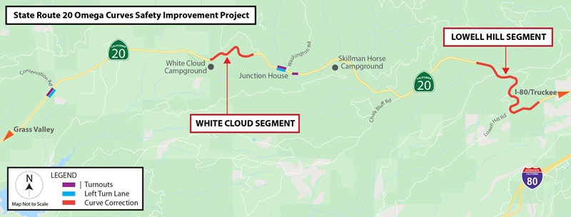
This project proposes to improve two non-contiguous segments of the alignment of State Route (SR) 20 in Nevada County between post miles (PM) 29.7-30.9 (White Cloud) and 36.8-39.8 (Lowell Hill) by modifying the existing horizontal and vertical curves of the roadway and adding turnouts. This project will update the roadway to current standards by increasing the curve radii, widening shoulders to 8 feet, adding turnouts for both directions, and improving the vertical profile grade. Additionally, the project will widen an existing turnout to standard width on SR-20 from PM 36.8 to 37.0.
Purpose
The purpose of this project is to improve safety and reduce the number and severity of collisions by increasing the curve radii, widening shoulders, adding turnouts, improving the vertical profile, and improving the clear recovery zone.
These two sections of roadway experienced a total of 39 collisions in a recent 3-year period (January 1, 2015 to December 31, 2017), including 19 collisions involving injuries. The resulting total accident rate is higher than the statewide average for a similar type of facility. In addition, this section of the existing two-lane conventional highway facility has no room to pass. Slow-moving traffic has the potential to delay traffic flow leading to unsafe passing movements.
Map
Funding
This project is funded by the 2020 State Highway Operation and Protection Program (SHOPP) under the Operational Improvement program.
Cost Estimate
Support Cost: $5,706,000
Capital Cost: $35,390,000
Total Project Cost: $41,096,000
Schedule
Project Approval & Environmental Document: April 2020
Design Completed: April 2021
Advertise Project: October 2021
Begin Construction: February 2022
Complete Construction: December 2025
News / Events
United States Forest Service
Caltrans has partnered with the United States Forest Service (USFS) to temporarily close trails impacted by project construction activities. USFS updates may be found using the below links.
Press Releases:
10.06.2023 State Route 20 Now Open in Nevada County
10.03.2023 White Cloud Segment Closed Along State Route 20 in Nevada County
09.26.2023 State Route 20 Closed in Nevada County
09.22.2023 State Route 20 Temporary Closure Begins Next Week
09.15.2023 Public Meeting Planned for State Route 20 Temporary Closure
09.08.23 Full Closure of State Route 20 Scheduled for Omega Curves Project
07.20.23 Blasting Work Extends Traffic Controls on State Route 20
07.03.23 One-Way Traffic Control Extended on State Route 20
06.16.23 Traffic Impacts Continue Due to SR-20 Omega Curves Project
04.28.23 Work Scheduled to Resume for SR-20 Omega Curves Project
10.05.22 Extended Traffic Holds for Blasting Work Ahead on State Route 20
08.19.22 Occasional Saturday Work Scheduled for SR-20 Omega Curves Project
07.21.22 Major State Route 20 Improvements Continue in Nevada County
06.09.22 Construction Work and Travel Delays Continue on State Route 20
05.13.22 Continued Traffic Delays Ahead for State Route 20 Safety Project
04.27.22 One-Way Traffic Control Ahead on State Routes 20/193
03.30.22 One-Way Traffic Control Continues on State Route 20
03.01.22 Caltrans Beginning Vegetation Removal for State Route 20 Safety Project
12.04.23 Work Continues Along State Route 20 in Nevada County
Project Contacts
Sam Vandell, Project Manager, (530) 741-4593; sam.vandell@dot.ca.gov
Jeremy Linder, Public Information Officer, (530) 701-5209; jeremy.linder@dot.ca.gov