District: District 3 - Marysville
Contact: Raquel Borrayo
Phone: (530) 701-5209
FOR IMMEDIATE RELEASE
Nevada County – Caltrans is beginning vegetation removal Wednesday, March 2 on State Route 20 (SR-20) in Nevada County prior to the start of major construction work on the Omega Curves Safety Improvement project.
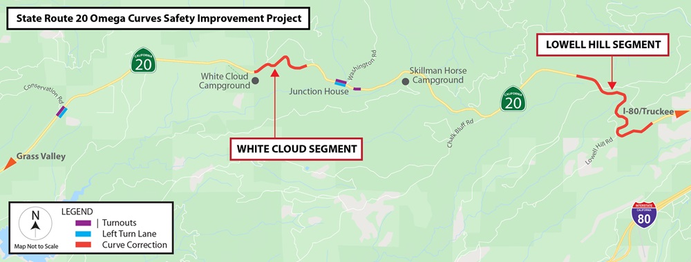
The $62.5 million Omega Curves project aims to improve safety and reduce collisions on SR-20 by realigning curves on two non-contiguous segments near White Cloud and Lowell Hill, widening shoulders, improving the highway’s sight distance and adding designated left turn lanes near Conservation Road and Washington Road. In addition, three turnouts will be added where slow-moving vehicles can permit motorists to safely pass, while also serving as traffic enforcement locations for the California Highway Patrol.
Vegetation removal for the project is anticipated Monday through Friday from 7 a.m. to 5 p.m. While much of the work will occur in shoulder areas, occasional one-way traffic control will be required through March. Motorists should expect delays of up to 20 minutes or up to 30 minutes for larger trees.
Anticipated vegetation work for this month is scheduled in order at the following locations:
- Between the White Cloud Campground and Shake Hill Road
- Prior to Last Chance Mine Road and past Lowell Hill Road
- Near Conservation Road and Pine Needle Lane
- Near Washington Road and Junction House
- Near the Skillman Horse Campground
Granite Construction, Inc. of Sacramento is the prime contractor for the safety project, which is scheduled to start major construction in mid-April. The project is expected to be finished in fall 2023.
To receive Omega Curves project updates via email, please contact Public Information Officer Raquel Borrayo at raquel.borrayo@dot.ca.gov or at (530) 701-5209.
District 3 is responsible for maintaining and operating 4,385 lane miles in 11 Sacramento Valley and Northern Sierra counties. Check out Caltrans' “QuickMap” for current road conditions and chain requirements at quickmap.dot.ca.gov/ or download the free QuickMap app on the App Store or Google Play. Motorists also can call the California Highway Information Network automated phone service at 1-800-427-ROAD (7623).
###


