
State Route 183 Castroville Improvement Project
![]()
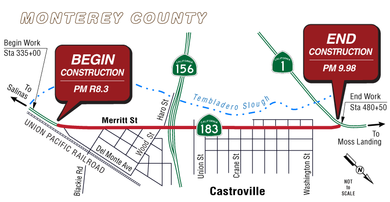
Project Description
This project aims to enhance safety, ride quality, and accessibility along Merritt Street (State Route 183) through Castroville from mile 8.3 to 9.98. Improvements include pavement rehabilitation, bridge repairs, upgraded transit stops, ADA-compliant sidewalks, bicycle lanes, and intelligent traffic systems.
Key Improvements
- Fresh asphalt overlay and pavement repairs
- Bridge deck and concrete repairs to extend lifespan
- ADA upgrades: sidewalks, curb ramps, crosswalks, and driveways
- Transit enhancements: new bays, relocated stops, improved access
- Bike safety designated Class 2 bike lanes added
- Traffic safety: widened shoulders, splitter islands, and curb tapers
- Traffic monitoring: upgraded sensors and a new CCTV camera at the State Route 183/State Route 156 interchange
Why It Matters
- Ensures smoother, longer-lasting pavement
- Reduces bridge damage and water intrusion
- Makes walking, riding, and transit access safer and more comfortable
- Supports real-time traffic management for better flow
Public Outreach
- August 26,2020 - Virtual town hall was held to present the project and gather feedback. Residents raised concerns about speeding and congestion downtown, leading to added traffic-calming measures in the design.
- May 7-June 11, 2021 - Public comment period for the draft environmental document.
- May 26, 2021 - Virtual public meeting via Webex/phone to review the draft environmental document and receive questions and comments.
- May 26, 2022 - Community information meeting, organized with TAMC and Monterey County, drew over 50 attendees to review project features and ask questions.
- Final environmental document completed: July 2021
- Right-of-way completed: June 2024
- Design completed: June 2024
- Advertise: October 2024
- Construction to begin: February 2025
- Construction to be completed: Winter 2027/2028
- Initial Study with Mitigated Negative Declaration/ Environmental Assessment with Finding of No Significant Impact (24.6 MB) (PDF)
- Castroville Ribbon Cutting Event English (PDF)
- Castroville Ribbon Cutting Event Spanish (PDF)
Estimated Funding Breakdown
State: $38,000,000
Construction Cost: $20,600,000
Community Partners
In collaboration with the Transportation Agency for Monterey County, Monterey-Salinas Transit, Monterey County, Castroville Community Services District, and North County Recreation and Park Department.
Estimated Project Schedule
Documents
Project Contact Info
Jackson Ho
(805) 276-1114
Jackson.Ho@dot.ca.gov
Matt Fowler, Senior Generalist
(805) 542-4603
Matt.Fowler@dot.ca.gov
Heidi Crawford, Public Affairs
(805) 549-3318
Title VI Information
The California Department of Transportation (Caltrans) assures that no person shall, on the basis of race, color, or national origin, be excluded from participation in, be denied the benefits of, or be otherwise subjected to discrimination under any program or activity receiving Federal financial assistance, as required by Title VI of the Civil Rights Act of 1964, as amended, the Civil Rights Restoration Act of 1987, and Federal Executive Order 12898 (Federal Actions to Address Environmental Justice in Minority Populations and Low-Income Populations).
Caltrans will make every effort to ensure nondiscrimination in all of its programs and activities, whether they are federally funded or not, and that services and benefits are fairly distributed to all people, regardless of race, color, or national origin. In addition, Caltrans will facilitate meaningful participation in the transportation planning process in a nondiscriminatory manner.