
Solomon Canyon Rumble Strip/Shoulder Widening
Project Description
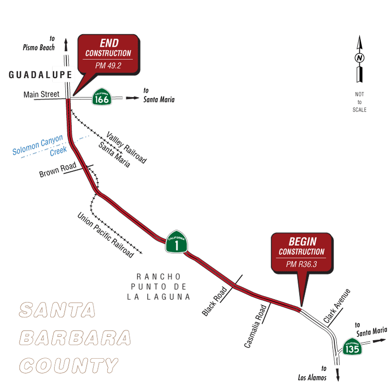
The project would make improvements to State Route 1 in Santa Barbara County, east of Santa Maria and north of the town of Orcutt. Within the project limits, State Route 1 is a two-lane undivided highway with 12-foot lanes and 0.5- to 1-foot non-standard shoulders. The purpose of the project is to reduce the number and severity of roadway departure crashes within this segment of the highway.
Within the project limits are three at-grade intersections: Solomon Road (post mile 36.3), Black Road (post mile 41.8), and Brown Road (post mile 47.2). The project area consists of 9.5 miles of two-lane highway passing through rich agricultural land on which high-value crops are grown year-round. Two bridges occur within the project area: Waldorf Overhead Bridge at post mile 46.4, which is used by the Union Pacific Railroad, and Solomon Canyon Creek Bridge at post mile 47.9, which crosses over Solomon Canyon Creek.
The project would widen shoulders to 8 feet between Solomon Canyon Road and Black Road and widen shoulders to 5 feet between Black Road and State Route 166, as recommended by Traffic Safety. It would also replace guardrail at spot locations that Traffic Safety deems necessary as a preventative measure in areas with steep side slopes or fixed objects. A historic concrete box culvert at post mile 42.7 would be extended as part of the shoulder widening work. The project would also raise the profile of the highway, gradually up to 5 feet, at two locations (post miles 40.5 and 41.4) that are susceptible to flooding. An exclusionary berm feature will be installed on the southern side of the highway between post miles 42.1 and 42.2 to impede California tiger salamander movement across the highway.
Other work includes extending and/or replacing 35 culverts to meet new slopes, constructing or modifying existing V-ditches, relocating utility poles and other fixed objects from the clear recovery zone, and installing centerline and edge-line rumble strips.
Right-of-way acquisition would be required for the shoulder widening and for a separate utility easement. Existing utility poles, fences, and other fixed objects would be relocated to outside of the clear recovery zone. A temporary construction easement is required to reconstruct the driveways and access roads at the locations where the profile would be raised due to flooding.
Project Benefits
Purpose: The purpose of the project is to reduce the number and severity of roadway departure crashes within this segment of the highway.
Need: The project is needed is to address collision rates within the project limits that exceed statewide rates for similar facilities. Within the project limits, shoulders are narrow or absent, bridge width and sight distance do not comply with current standards, super-elevation rates are nonstandard, and fixed objects are located within the clear recovery zone. The project was identified in the California Roadway Departure Safety Implementation Plan, which was created based on guidelines from the Federal Highway Administration Roadway Departure Safety Program.
Funding
The project was programmed in the 2020 State Highway Operation and Protection Program and is included in the Santa Barbara County Association of Governments’ approved 2019 Federal Transportation Improvement Program, under EA 05-1H610. The project is also included in the Santa Barbara County Association of Governments’ approved 2040 Regional Transportation Plan (2017) under “State Highway Operation and Protection Program funded Collision Reduction projects.” Construction is currently scheduled to begin in early 2024, and the total estimated cost for the build alternative is $19 million.
Partnerships
Federal Highway Administration
Proposed Project Schedule
- Final Environmental Document to be completed: Summer 2021
- Right of way acquisition to be completed: Summer 2023
- Design to be completed: Fall 2023
- Advertise: Fall 2024
- Construction to begin: Winter 2024
- Construction to be completed: Spring 2026
Contact
District 5 Public Affairs
50 Higuera Street
San Luis Obispo, CA 93401
Phone: (805) 549-3111
Email: info-d5@dot.ca.gov
Jason Wilkinson, Environmental Branch Chief
Phone:
805-540-9165
Email:
jason.wilkinson@dot.ca.gov
Justin Borders, Project Manager
Phone:
(805) 542-4718
Email:
justin.borders@dot.ca.gov