Welcome to the Oakland Alameda Access Project Toolkit
Are you a San Francisco-Bay Area resident, neighbor, student, employee, commuter, pedestrian, employee, or motorist? Then this information is just for you. This toolkit is a valuable resource to inform and prepare you for Caltrans’ Oakland-Alameda Access Project getting underway soon from 2026-2029. This project aims to address safety, connectivity, and mobility issues in Oakland Chinatown, the Jack London District, and City of Alameda.
If you’re learning about the Oakland Alameda Access Project for the first time, here’s a breakdown of what’s happening:
- Oakland-Alameda Access Project: Roadway and freeway access improvements between I-880, I-980, and the Posey/Webster Tubes, a new pedestrian and bike pathway in the Webster Tube, safer intersections, new and upgraded sidewalks and bike facilities, project limits are on Route 260 from Willie Stargell Avenue to 7th Street and on Route 880 from 23rd Avenue to Washington Street in Alameda and Oakland, in Alameda County.
Why is it so important to remain informed and prepared about these projects? One major reason: TRAFFIC IMPACT!
The traffic impact will be significant, causing delays and disruptions to your normal commute routine. Motorists using the Webster and Posey tubes and I-880 under construction will experience delays and may be required to take detours which will make trips longer. Please plan ahead and consider using public transportation. The Posey and Webster tubes will be entirely closed (during certain nighttime and weekend dates). While closures are underway, WEST ALAMEDA REMAINS OPEN, so please PLAN AHEAD to reach your business, pleasure, and routine destinations on time. Construction will begin early 2026. The duration of each of this project is approximately three years.
Public Events Coming:
In addition to sharing this toolkit, we want to raise awareness of PUBLIC MEETINGS TO BE SCHEDULED SOON. We ask that you consider using this toolkit to encourage your networks to check Oakland Alameda Access Project | Caltrans regularly for updates. The toolkit is organized by the type of platforms partner may use to help spread the word including by website, eblast/newsletter, social media, digital calendar, and flyer. We invite you to share this information through your community and organization’s communication channels. Feel free to tailor the messaging in the toolkit, but please maintain the accuracy and intent of the content. If you have any questions about the project or need clarification about the materials, please don’t hesitate to contact us at oaapcommunications@dot.ca.gov. For more information, please visit: Oakland Alameda Access Project | Caltrans
Project News and Updates:
Stay informed and sign up here or click on the form below to get news and updates about the Oakland Alameda Access Project!

Oakland Alameda Access Project Updates
To ensure the safety and operability of Oakland – Alameda freeways and the safety of the traveling public and work crews, Caltrans aims to address roadway and freeway access improvements. Read more about this important project.
Oakland Alameda Access Project
Freeway access and local roadway improvements (Scheduled to begin in early 2026)
Location: Between I-880, I-980, and the Posey/Webster Tubes connecting the two cities
SCOPE:
-
Roadway and freeway access improvements between I-880, I-980, and the Posey/Webster tubes, a new pedestrian and bike pathway in the Webster Tube, safer intersections, new and upgraded sidewalks and bike facilities.
IMPACTS:
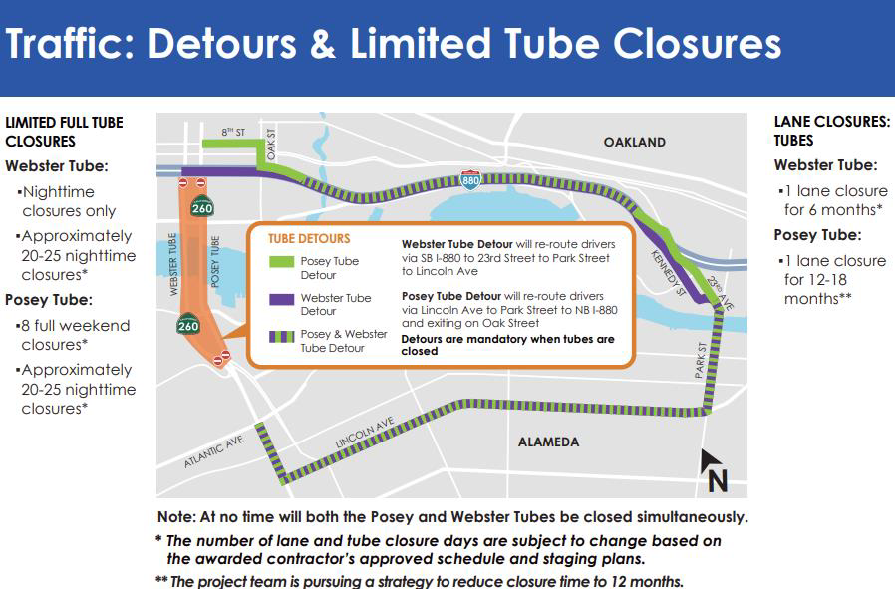
- Limited Full Tube Closures
-
Webster Tube
Nighttime closures only
Approximately 2-25 nighttime closures -
Posey Tube
8 full weekend closures
Approximately 20-25 nighttime closures
-
-
Expect traffic delays as one lane of both Posey and Webster tubes will be closed. Residents, students, commuters, and shoppers most impacted.
-
Note: At no time will both the Posey and Webster Tube be closed simultaneously.
-
For more information please visit the project page.
OAAP Frequently Asked Questions
The Oakland Alameda Access Project (OAAP) is a major infrastructure project designed to enhance safety, reduce congestion, and improve bike and pedestrian connectivity in downtown Oakland, Chinatown, and the City of Alameda.
Currently, drivers navigating between I-880, I-980, and the Webster and Posey Tubes must contend with congested city streets, which leads to bottlenecks, delays, and vehicle-pedestrian conflicts. OAAP will address these issues through improved roadway design, safer intersections, reduced emissions, and better access for all modes of transportation. Construction is anticipated to begin in early Fall 2025 and last approximately 3.5 years. During much of this time, travelers who use the Webster and Posey Tubes should expect longer trips as well as limited tube closures (select nighttime and weekend dates). Before construction begins, you can stay informed by joining the project contact list (oaapcommunications@dot.ca.gov) and follow updates at OaklandAlamedaAccessProject.com Once the contractor is selected, Caltrans will lead public outreach and construction updates including information about upcoming tube closures and detours, and construction activities. A detour will reroute traffic via Lincoln Avenue to Park Street, then onto northbound I-880, exiting at Oak Street.
Project Benefits Include:
- Connectivity: Improves travel connection between Alameda & I-880 regional travel, and between Alameda & Downtown Oakland (bike, car, pedestrians);
- Reduced Traffic: Reduces neighborhood cut-through traffic and improved freeway access;
- Safety: Improves safety in communities heavily impacted by cut-through traffic including in Chinatown, where more than 60 percent of Oakland’s severe and fatal accidents occur;
- Bike & Pedestrians: Provides a new facility in Webster Tube & improves access in Posey Tube to better connect Oakland & Alameda; Safety & accessibility improvements at intersections, added sidewalks and bike facilities in Oakland & Alameda;
- Climate Equity: Reduces emissions in equity community with air pollution/ high particulate matter exposure.
The Alameda CTC is the project sponsor, working in partnership with the California Department of Transportation (Caltrans) and the Cities of Oakland and Alameda. Caltrans is the implementing agency for construction work and distributing public information during the construction phase. The estimated total project cost is $175.4 million, which is funded by Alameda CTC local, state and federal funding.
The project aims to address safety, connectivity, and mobility issues in Oakland Chinatown, the Jack London District, and Alameda. The project addresses:
- Congested city streets with long travel delays;
- Indirect routes to access the freeway and the Tubes;
- Operationally deficient intersections;
- Vehicle-pedestrian conflicts within local neighborhoods (especially around Chinatown);
- Lack of pedestrian and bicycle connectivity; and
- The visual and physical barrier created by the I-880 overhead structure.
- Connectivity: Improves travel connection between Alameda & I-880 regional travel, and between Alameda & Downtown Oakland (bike, car, pedestrians);
- Reduced Traffic: Eases traffic congestion and cut-through traffic on neighborhood streets, and improved connection to I-880/ regional travel;
- Safety: Improves safety in communities heavily impacted by cut-through traffic including in Chinatown, where more than 60 percent of Oakland’s severe and fatal accidents occur;
- Bike & Pedestrians: Provides a new facility in Webster Tube & improve access in Posey Tube to better connect Oakland & Alameda; Safety & accessibility improvements at intersections, added sidewalks and bike facilities in Oakland & Alameda;
- Climate Equity: Reduces emissions in equity community experiencing elevated air pollution/ high particulate matter exposure.
- Upgrading the Tubes is a faster, cost-effective way to improve access between Oakland and Alameda now—while longer-term solutions like a new bridge over the estuary are still being studied by other agencies.
- No. The project is fully funded with State,and local sales tax Measure B and Measure BB funding.
- Additional information about Measure B and BB may be found at: https://www.alamedactc.org/funding/fund-sources
The project will improve conditions for walkers and cyclists by:
- Re-routing significant freeway-bound traffic out of neighborhoods;
- Adding safety features at intersections: crosswalk striping, curb bulb-outs, pedestrian hybrid beacon, separated/protected and leading pedestrian interval traffic signal phases, no-turn-on-red restrictions;
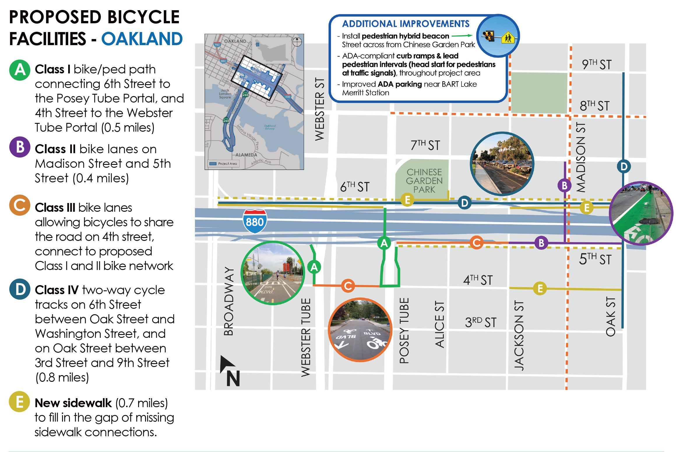
- Building continuous sidewalks/filling in the missing sidewalk gaps; adding one and a half+ miles of new bike paths and bike lanes;
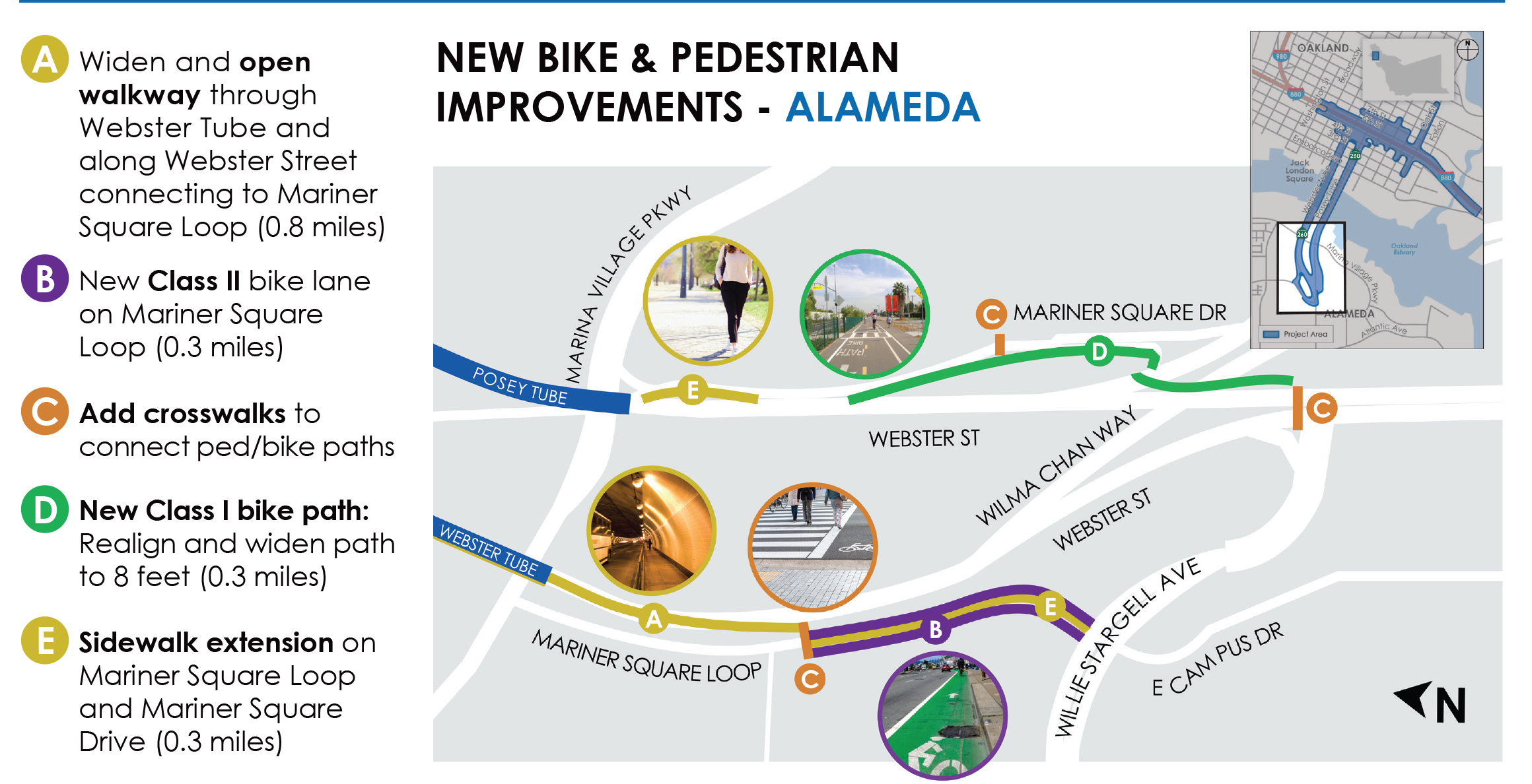
- Introducing a new protected pathway for shared use by pedestrians and cyclists in the Webster Tube (not a designated bike lane); and
- A new crosswalk at Tynan Avenue and Mariner Square Drive will be installed, allowing pedestrians and cyclists to cross Mariner Square Drive to reach their destination inside the Posey Tube. This new crosswalk will be visible with new painted stripes and equipped with warning signs to alert motorists to yield to pedestrians and bicyclists.
Letters A through E on the map below show bike access improvements for the Tubes in Oakland:
Letters A through E on the map below show bike access improvements to the Tubes in Alameda:
The project will improve freeway access to and from the Tubes and in the vicinity through the following:
For the northbound (NB) I-880 direction:
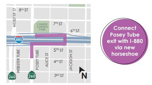
- The “horseshoe ramp” will provide direct access from the Posey Tube exit to NB I-880. Motorists leaving Alameda via the Posey Tube seeking connection to NB I-880 will make a right turn onto the new "horseshoe ramp" and bypass the Chinatown surface streets, instead going under the freeway and connect to NB I-880 without stoplights or stop signs.
- Traffic circulation for motorists on surface streets in Chinatown will remain unchanged in accessing NB I-880, maintaining the same access point from the intersection of Jackson and 6th Street.
- The NB I-880 Broadway off-ramp will be removed to eliminate weaving conflicts between the Jackson Street on-ramp and Broadway Street off-ramp and provide continuous street network on 6th Street, between Oak Street and Broadway.
Because of the removal of the Broadway off-ramp, the Oak Street off-ramp at NB I-880 will be widened. The distance of travel between NB I-880 and Webster Tube will also be shortened to provide a direct left turn movement at the intersection of 6th and Webster Street, instead of the loop on-ramp at 5th Street and Broadway.
The map below shows the improved freeway access route:
Southbound (SB) I-880:
- The existing SB I-880 on-ramp at 5th Street, just east of Oak Street, will continue to provide SB I-880 access from surface streets.
- Travelers exiting the Posey Tube seeking the SB I-880 will take the right lane which will offer motorists the chance to continue onto 5th Street. This stretch of 5th Street will be improved to provide more streamlined access to SB I-880, helping address current bottlenecks.
- The existing SB I-880 onramp at Broadway and 5th streets, just east of Oak Street, will continue to provide SB I-880 access; and this intersection will be improved, as will the Webster Tube approach.
Northbound (EB) I-980:
- Access to I-980 from Alameda, the Jack London District, and Chinatown will not change. The new horseshoe ramp described above will improve the route by shortening travel times.
- Motorists leaving Alameda will no longer need to travel through the surface streets of Chinatown to reach EB I-980. The right lane from the Posey Tube will enter the horseshoe ramp, directing motorists to NB I-880 which then leads to EB I-980.
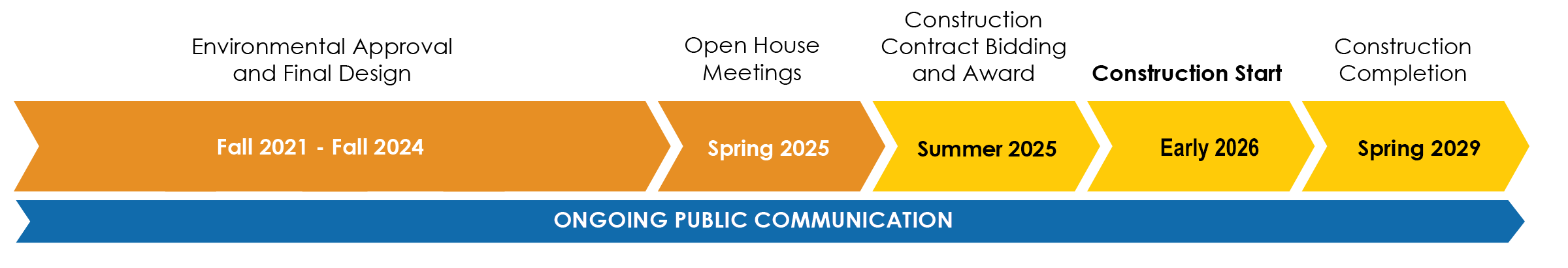
- The project has completed final design, environmental review, project approvals and is currently in the construction contract awarding process.
- Construction is expected to begin in early 2026.
To receive project news, sign up for email updates by contacting oaapcommunications@dot.ca.gov.
- Stay informed by signing sign up for email updates with oaapcommunications@dot.ca.gov and follow updates at OaklandAlamedaAccessProject.com.
- Once the contractor is selected, Caltrans will lead public outreach and construction updates including information about upcoming tube closures and detours, and construction activities using:
- Brochures and mailers
- Commercial traffic radio
- Fixed and portable changeable message signs
- Ground mounted construction signage
- Online mapping (Google/Apple Maps)
- Press releases & media alerts
- Project website and social media
- Public meetings
- Stakeholder meetings
- Telephone hotline
- If you have a question or comment, please email oaapcommunications@dot.ca.gov. Questions will be responded to as soon as possible.
- Travel through the Tubes will remain available with at least one lane being open, with the exception of limited tube closures at nights and weekends.
- Aside from limited closure dates, drivers will have the option to travel through the Tubes with one lane open and delayed travel time, or follow detour signage.
- Traffic lane closures in the Tubes and project vicinity will result in travel time delays.
- Construction activities in the Webster Tube will be completed before lane closures in the Posey Tube are implemented.
- The detour for the Webster Tube will route drivers via southbound I-880 to the Kennedy Street exit, and then along 23rd/Park Avenue crossing the Bay Estuary, and then along Lincoln Avenue.
- The detour for the Posey Tube will route drivers via Lincoln Avenue to Oak Street, crossing the Bay Estuary at 23rd/Park Avenue and onto the I-880 northbound.
- To stay informed, please join the project mailing list at oaapcommunications@dot.ca.gov.
Map of project area, including detours:
- Continued coordination with emergency service providers, including the City of Alameda Emergency Operation Center, Oakland Fire Department, Oakland Police Department, State of California Fire Marshal, and the City of Alameda Fire and Emergency Services.
- Emergency services will be informed before any public road closure. They will also receive weekly construction updates.
- The contractor is required to accommodate access for emergency vehicles and, if necessary, close or modify construction operations.
- Pedestrian and Bicycle access will be maintained at all times. Signage for detour routes will be provided as needed.
- Alternative transportation options are available and include BART, the water shuttle, AC Transit and bike share services and project planners are evaluating service availability. Coordination with these services continues to promote other travel options.
- Project leaders continue to coordinate with AC Transit and ground shuttle providers to minimize service delays and keep riders informed.
Project Media Gallery
Additional project resources including downloadable maps, image galleries, and video clips can be found on the media resources page.
![]()
Stay Informed & Plan Ahead
For updates, project maps, and detour info:
Visit: www.dot.ca.gov | Caltrans Info Line: 1-800-427-7623
Thank you for your patience as we work to improve our roads and infrastructure.
Connect With Caltrans District 4 On Social Media
![]()
![]()
![]()
![]()
#CaltransLovestheBay