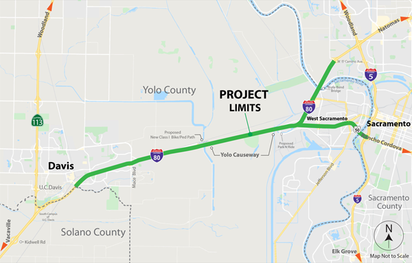
Yolo 80 Corridor Improvements Project

Description

Introduction

The California Department of Transportation (Caltrans), in collaboration with stakeholders, proposes to construct improvements consisting of managed lanes, pedestrian/bicycle facilities, and Intelligent Transportation System (ITS) elements along Interstate 80 (I-80) and United States Route 50 (US-50) from Kidwell Road near the eastern Solano County boundary (near Dixon), through Yolo County, and to West El Camino Avenue on I-80 and Interstate 5 (I-5) on US-50 in Sacramento County.
Map of I-80

Caltrans, as assigned by the Federal Highway Administration (FHWA), is the lead agency under the National Environmental Policy Act (NEPA) for the Caltrans EA 3H900 Yolo 80 Managed Lanes Project (project). Caltrans is also the lead agency under the California Environmental Quality Act (CEQA).

Project Background

Corridor Overview

The project is located in Solano, Yolo, and Sacramento Counties on the I-80 corridor between Kidwell Road and the Solano/Yolo County line , and  between the Solano/Yolo County line and the   Yolo/Sacramento County line , and between the  Yolo/Sacramento County line and West El Camino Avenue; on the US-50 corridor between the I-80/I-50 interchange to the Yolo/Sacramento County line, and between the Yolo/Sacramento County to the US-50/I-5 interchange. The total project length is approximately 20.8 miles.

I-80

I-80 is a critical link to regional and interregional traffic as the only freeway connection between the San Francisco Bay Area and the Sacramento Metropolitan region. The route also links the Bay Area with recreational destinations in the Sierra Nevada Mountains and points north via I-505 to I-5. 

In Solano County, within the project limits, I-80 is an eight-lane Freeway with four eastbound and four westbound lanes separated by a paved and/or unpaved center median with a guard rail barrier or concrete barrier. Each direction of travel consists of four travel lanes with standard outside shoulders in each direction.

Within project limits, I-80 generally has three eastbound and three westbound lanes separated by a paved and/or unpaved center median with a guard rail or concrete barrier. However, in Yolo County, between about PM 9.0 to 9.6, I-80 widens to eight lanes. I-80 has variable outside shoulders widths in each direction. The corridor travels through the City of Davis and the City of West Sacramento. Class I bike/ped facility would be constructed from western terminus of Yolo Causeway, west, along I-80 and WB CR 32A Off-Ramp to connect with CR 32A. CR 32A is located north of I-80 and east of the Mace Boulevard interchange and acts as a frontage road to the Yolo Bypass, where I-80 becomes a causeway.

In Sacramento County, within the project limits, I-80 is a six-lane Freeway with three eastbound and three westbound lanes separated by a paved center median of varying width and concrete and/or guardrail center median barriers. Each direction of travel consists of three travel lanes with standard outside shoulders in each direction.

Amtrak, Fairfield/Suisun Transit, Vallejo Baylink Ferry, Solano Express Bus, Yolobus, and Greyhound Bus. Bicycle and pedestrian accessibility is provided via the surrounding arterial network.

Purpose and Need

Purpose

The purpose of the proposed project is to:

  • Ease congestion and improve overall person throughput1.
  • Improve freeway operation on the mainline, ramps, and at system interchanges.
  • Support reliable transport of goods and services throughout the region.
  • Improve modality2 and travel time reliability.
  • Provide expedited traveler information and monitoring systems.

Need

The proposed project is needed for the following reasons:

  • Recurring congestion during the AM and PM peak periods exceeds current design capacity limiting person throughput.
  • Operational inefficiencies lead to the formation of bottlenecks due to short weaving and merging areas as well as lane drops.
  • Inefficient movement of goods and services impedes regional and interstate economic sustainability.
  • The corridor users rely heavily on single occupancy vehicles, with limited multi-modal options such as transit, carpool, bicycle, and pedestrian facilities resulting in unreliable travel times.
  • Lack of real time traveler information and coordinated traffic communication systems impedes timely response to roadway incidents resulting in secondary collisions and increased non-recurring congestion.

1 Throughput is the number of people moving efficiently through a region.

2 Modality is the variety in modes of transportation. This includes access and multiple options for the movement of people and goods. Examples include access to transit, carpool, bicycle, and pedestrian facilities.

Project Description

Caltrans proposes to make improvements on the I-80 corridor between Postmile (PM) 40.7 (west of Kidwell Road Interchange) and PM 44.7 (Solano/Yolo County Line) in Solano County, between PMs 0.00 (Solano/Yolo County Line) and 11.72 (Sacramento River, Bryte Bend Bridge) in Yolo County, and between PMs 0.00 (Sacramento River, Bryte Bend Bridge) and 1.36 (West El Camino Interchange) in Sacramento County; and US-50 between PMs 0.00 (I-80/US 50 Junction) and 3.12 (Sacramento River, Pioneer Bridge) in Yolo County and between PMs 0.00 (Sacramento River, Pioneer Bridge) and 0.617 (US 50/I-5 Junction) in Sacramento County. The project proposes to add managed lanes on I-80 and US 50 by a combination of lane conversion, restriping, shoulder, and median reconstruction with a concrete barrier. Drainage modifications would be required due to median reconstruction in the locations to which sheet flow currently drains. Existing Intelligent Transportation System (ITS) elements and infrastructure would be modified and new ITS elements will be added which includes ramp meters, fiber-optic conduit and cables, and overhead changeable message (CMS) signs.

Project Alternatives

This section describes alternatives that were developed to meet the purpose and need of the project. The Build Alternatives are listed below. While each Build Alternative proposes a different managed lane type, only two unique geometric footprints are proposed (e.g., Build Alternatives 2-6 and Build Alternative 8).  Build Alternative 7 would not construct new lanes. 

  • No build: Alternative 1: This alternative does not address the purpose and need of the project by not making corridor improvements and relieving traffic congestion.
  • Build Alternative 2: Add a High Occupancy Vehicle (HOV) lane in each direction for use by vehicles with two or more riders (HOV 2+).
  • Build Alternative 3: Add a High Occupancy Toll (HOT) in each direction for use by vehicles with two or more riders (HOT 2+).
  • Build Alternative 4: Add a HOT lane in each direction for use by vehicles with three or more riders (HOT 3+) Lane in Each Direction.
  • Build Alternative 5: Add an Express Lane in each direction (everyone using the lane pays to use the lane, regardless of number of riders.).
  • Build Alternative 6: Add a Transit-only lane in each direction.
  • Build Alternative 7: Repurpose the current #1 general purpose lane to HOV 2+.No new lanes would be constructed.
  • Build Alternative 8: Add a HOV 2+ lane in each direction with I-80 connector ramp.

Total Project Cost

Total Project Cost - $200M - $300M depending on Alternative

Schedule

Draft Environmental Document (DED) for Public Review: Summer 2023

Final Environmental Document and Clearance Complete: Winter 2023

Design Complete: Summer 2025

Construction Start: Fall 2025

Contact Us

Gurtej Bhattal
Project Manager

Masum A Patwary
Environmental Coordinator

Dennis Keaton
Public Information Officer

Comments:
Yolo80corridor@dot.ca.gov  (530) 812-7634

Check out the 
Alternatives

Helpful Links

  • Check out the Transit Providers to find one in your area, and even use the Google Transit Trip Planner to find routes and times for Regional Transit, Roseville Transit or Yolo Bus services.
  • Check out the Seats Available in vanpools, or find out how to start your own here.

Partner Links