197/199 Safe STAA Access
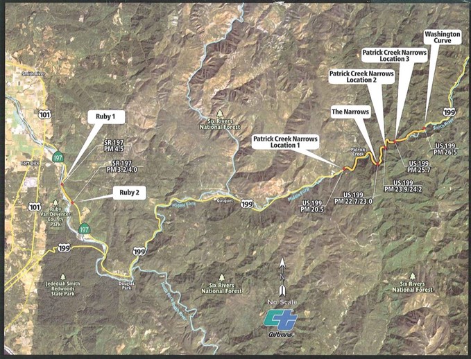
The 197/199 Safe STAA Access Project aims to upgrade sections of Route 197 and U.S. 199 in Del Norte County to meet the standards for STAA truck routes. These improvements involve widening lanes and adjusting curves to accommodate larger trucks while enhancing safety for all travelers. Currently, these areas pose risks due to narrow lanes and limited visibility, leading to potential accidents. By making these enhancements, the route can facilitate safer and more efficient movement of goods between Crescent City and Interstate 5 (I-5), benefiting both truck drivers and other road users.

Purpose and Need
The purpose of the proposed project is to construct improvements at spot locations along Route 197 and U.S. 199 in Del Norte County to allow the reclassification of the corridor as part of the industry standard STAA network of truck routes. These improvements include widening lanes and modifying curve geometry at identified locations to accommodate standard STAA-sized vehicles while maintaining and improving safety for the traveling public.
All seven locations included as part of the proposed project have roadway geometries that can result in STAA trucks and other long-wheelbase vehicles off-tracking across the double yellow line and entering the oncoming traffic lane. Additionally, limited sight distance at all seven locations does not allow enough time for drivers to react to roadway conditions ahead. Lack of STAA truck access on the 197/199 corridor restricts options for goods movement between Crescent City and I-5. Safety-enhancing improvements, including wider lanes, wider shoulders, longer radius curves and improved sight distances are needed to provide a roadway that is safer and easier to maneuver for all users.
Timeline
Construction is currently estimated to begin in summer 2026.
Traffic Impacts
Travelers should plan for delays along the 199/197 corridor while construction is underway. It's recommended to follow Caltrans District 1 on social media (Facebook, Instagram, Twitter) and check our weekly Road Information Bulletin.
For more information, contact:
Project Manager
David Melendrez
(707) 572-0831, TTY 711
Public Information (Media Inquiries)
Myles Cochrane
(707) 498-4272, TTY 711
Last reviewed: October 2025


