
After the Devastation, a Safer Highway System
Loma Prieta, Other Quakes Give Caltrans Valuable Lessons in Seismic Engineering
Thirty years ago, the Loma Prieta earthquake killed 63 people in the Bay Area and presented Caltrans with one of its biggest challenges: how to ensure the safety of people traveling on the thousands of bridges within the State Highway System, especially in quake-prone regions.
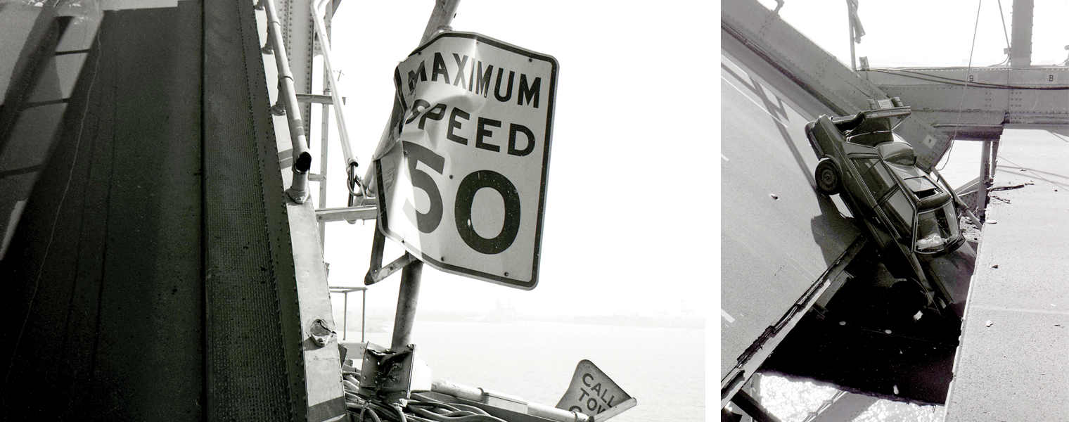
Forty-two of the deaths attributed to the quake that struck on Oct. 17, 1989, occurred on the Cypress Street Viaduct in Oakland. The double-deck bridge structure, which opened to traffic in 1957 as part of the Nimitz Freeway (Interstate 880), “pancaked” along a 0.7-mile stretch of the upper deck between 16th Street and the MacArthur Maze. Caltrans maintenance crews, engineers, surveyors and support staff worked around the clock for weeks to shore up the structure and perform rescue, recovery and demolition duties.
The 6.9-magnitude temblor centered in the Santa Cruz Mountains also caused the partial collapse of the upper-deck, 50-foot portion of the eastern span of the San Francisco-Oakland Bay Bridge, which opened in 1936. A passenger traveling on the damaged bridge after the earthquake was killed. A month to the day after the disaster, Caltrans had completed permanent repairs and the Bay Bridge was reopened.
About 60 miles south of the bridge, close to the epicenter, rockslides and heavily damaged pavement forced the closure of State Route 17 between Santa Cruz and Los Gatos for several weeks.
Loma Prieta, which happened at 5:04 p.m. on a Tuesday, was the largest Bay Area earthquake since 1906. As devastating as it was, the quake would have killed more travelers on the two damaged bridges had it not been for the fact that the Oakland Athletics and San Francisco Giants were 30 minutes from starting Game 3 of the World Series. Many people who routinely commuted on those bridges had left work early to watch the game.
Caltrans was initially the target of blame for catastrophic failure of the Cypress structure. One reporter even asked the Department’s state bridge engineer at the time, James E. Roberts, what it felt like to have blood on his hands. Such emotional allegations subsided, however, as certain facts became more widely known: The two-tier roadway was constructed before seismic engineering was a major component of bridge design, the viaduct was built upon unstable soil, and time simply ran out on plans to strengthen its entire 1.6-mile stretch of elevated highway.
The Lead-up and the Aftermath
Two earlier ground-shaking events in Southern California prior to Loma Prieta — the 6.5-magnitude San Fernando earthquake in 1971 and the 5.9-magnitude Whittier Narrows earthquake in 1987 — spurred Caltrans to change its seismic-related procedures. After the San Fernando Valley quake, the Department sent teams of engineers to study damage and make note of lessons learned.
As a result, retrofit requirements were changed. Columns were made more shear-resistant and able to withstand deformation, and modified to resist being pulled out of the foundation. In addition, the widths of hinges and expansion joints on the structures were widened. After Whittier, Caltrans updated its retrofit program to begin the practice of wrapping existing bridge columns in steel or fiber-reinforced polymer casings.
The Cypress Street Viaduct was on the list of bridges to be retrofit.
After Loma Prieta, then-Gov. George Deukmejian created a Board of Inquiry that concluded Caltrans needed to accelerate and expand its retrofitting efforts. Over the next four years, the Department made 1,039 bridges more earthquake-resistant at a cost of $1.08 billion.
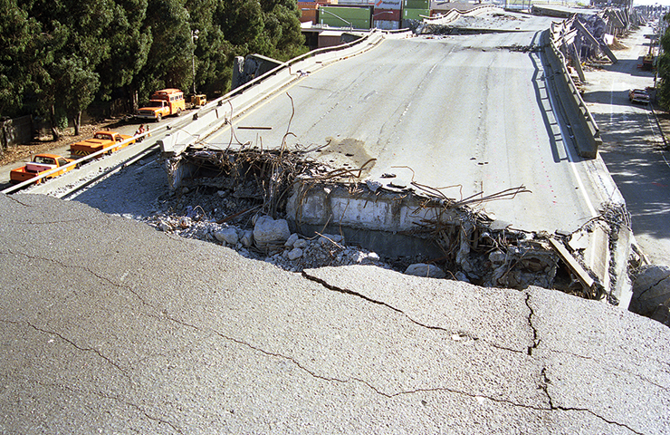
Then on Jan. 17, 1994, the Southern California region was struck by a massive earthquake. The 6.7-magnitude Northridge quake killed 57 people and caused an estimated $50 billion in damage.
But, like Loma Prieta, things could have been much worse. The Northridge quake struck at 4:31 a.m. on a holiday, when few people were on the roads. Although a California Highway Patrol officer died when his motorcycle plunged off a fallen bridge in Sylmar, no fatalities occurred when portions of the Santa Monica Freeway (part of Interstate 10) collapsed.
Those structural failures aside, later it was determined that all 60 bridges in the Los Angeles metro area that Caltrans had retrofitted since Loma Prieta made it through the Northridge quake in good shape.
After Northridge, in what is referred to as Phase 2 of the statewide retrofit program, Caltrans made seismic-safety upgrades on 1,155 more bridges at a total cost of $1.35 billion.
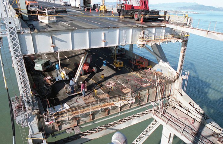
Starting in 1997, Caltrans began systematically retrofitting or replacing the nine state-owned toll bridges — the Antioch Bridge, Benicia-Martinez Bridge, Carquinez Bridge, Dumbarton Bridge, Richmond-San Rafael Bridge, San Diego-Coronado Bridge, San Francisco-Oakland Bay Bridge, San Mateo-Hayward Bridge and the Vincent Thomas Bridge — at an approximate cost of $9 billion.
Caltrans also plays an important role in a separate retrofit program in which local agencies are responsible for assessing the need for seismic retrofit work on non-state, publicly owned bridges. Caltrans must approve the scope of retrofit work and provide funding. As of July, a total of 1,181 bridges under the local agency program have undergone about $1.4 billion in retrofits. Fourteen bridges are still being upgraded and 47 are in design, representing a $400 million investment.
Today, continuing inspections are a critical part of the process. Periodic rescreening of state bridges is conducted to assess the structures for seismic vulnerabilities using the most current seismic criteria. The most recent rescreening was completed in 2019.
Bridge Engineers Make Adjustments
Prior to Loma Prieta, the primary seismic measurement that bridge designers considered was force. For instance, if you put a truck on the bridge, what is the force that the bridge must resist?
The ground movement that twisted and broke the Cypress structure, however, exposed a major drawback with force-based design: Making a bridge “stronger” has the unfortunate effect of intensifying seismic forces when a span is exposed to ground-shaking. For example, if a bridge’s columns are strengthened by making the column bigger or by adding more main reinforcement, larger seismic forces will be transferred to other parts of the bridge that might fail instead. Something has to give, in other words.
This realization prompted Caltrans to replace a force-based design with deformation-based design. Also referred to as displacement-based design, the columns are designed to act as fuses, to limit the force (but allow larger displacements) during earthquakes.
The Northridge earthquake brought another significant change in bridge design and retrofitting. One lesson learned from the collapse of the Newhall Overpass at the interchange of Interstate 5 and State Route 14 was that during a strong earthquake, short columns cannot displace as much seismic force as adjacent taller columns and can fail.
From there, achieving a balance of stiffness became a guiding principle for bridge designers. One of the strategies to make short columns as earthquake-resistant as their taller neighbors in what bridge engineers call “isolation casings.” This technique for balancing shorter columns is to place them in a pipe under the ground, making them in effect taller. The pipe would be wide enough to allow movement of the column placed inside.
Another balancing technique (usually for new bridges) when the columns are of different heights, is to vary their diameters. In this way, a tall column could be modified to have the same flexibility as a neighboring shorter column. The idea behind both of these techniques is to achieve balance.
The western portion (where Interstate 680 traffic heads south) of the Benicia-Martinez Bridge in the Bay Area illustrates how deformation and balance are factored into retrofitting of an existing large span. Each of its massive piers that rise from the water is topped with an isolation device: a 13-foot-wide “dish” in which a metal ball supports the bridge deck and can slide around on the dish should shaking occur. That allows different parts of the structure to move without damaging the vulnerable piers below the isolator dish.
Finding a Realistic Path Forward
Because it is impossible to say when the next big earthquake will occur, how strong it will be or where its effects will most be felt, Caltrans can make no guarantees about how the state’s bridges will perform. There is perhaps no such thing as an earthquake-proof bridge. Caltrans’ budget is never going to be large enough to cover every contingency.
In acknowledgement of that fact, Caltrans bridge engineers take a “probabilistic” approach to seismic safety.
Systemwide, they have adopted the philosophy that the structures that are built and retrofitted will survive a once-in-a-thousand-year earthquake. Similar to how governmental officials and water engineers talk about 100-year and 200-year floods, bridge engineers calculate in terms of 100-year, 500-year, 1,000-year and 2,500-year earthquake events.
Caltrans has concluded that in the case of a 1,000-year earthquake, a modern bridge will sustain damage, but the probability of collapse is very small. However, if the same bridge is subjected to a massive 2,500-year event, significant damage will occur, and the probability of collapse increases.
The 1,000-year bridge, like any insurance policy that becomes more expensive as the risks are reduced, is now the standard what Caltrans now can afford in earthquake-prone areas. Because funding is finite and many parts of the state are less susceptible to large earthquakes events, Caltrans prioritizes where it conducts seismic retrofitting. The Los Angeles and San Francisco areas obviously receive a lot of attention, but so do San Bernardino and Eureka, to name two smaller at-risk regions.
Although the public tends to measure earthquake strength based on the Richter scale — their magnitude — Caltrans bridge engineers focus on the earthquakes’ effects upon bridges. Strong shaking, soil liquefaction, fault offset, and other hazards are part of engineers’ risk assessments.
Another test of the quake-resistant highway system came July 4-5 when two major earthquakes — 6.4 and 7.1 on the Richter scale — struck the Southern California desert area of Ridgecrest. Thankfully, the impact on the regional road network was relatively limited. Portions of State Route 178 sustained roadway damage that was quickly fixed, and a series of rockslides caused by the quakes were cleared away, but there was no discernible damage to any of the roughly 30 bridges that were subsequently inspected.
It’s inevitable that damaging earthquakes will strike California in the future. Caltrans is using the knowledge gathered from past events to make its bridges and highways safer for the traveling public today and far into the future.
Sources: Mark Mahan, Office Chief, Caltrans’ Earthquake Engineering Analysis and Research, and Senior Bridge Engineer Mark Yashinsky.
ShakeCast Speeds Up Quake Response
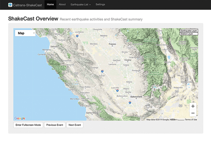
One tool available to emergency responders in the immediate aftermath of an earthquake is Caltrans’ ShakeCast, a website that shares information such as the exact epicenter location, magnitude, depth and origin time of temblors detected within California.
As explained on the site, ShakeCast “automatically retrieves shaking intensity data and performs analyses using structural models of Caltrans bridges and buildings.
“By focusing inspection efforts on the most damage-susceptible facilities in the most severely shaken areas, ShakeCast can drastically reduce Caltrans' response time in the aftermath of a major earthquake.”
ShakeCast data is gathered by more than 1,900 seismic sensors throughout the state. The open-source web application was developed by the U.S. Geological Survey in 2003, and customized in cooperation with Caltrans’ Division of Research, Innovation and System Information to offer a specialized service that focuses on Caltrans bridges and buildings.
The site’s interactive map, which has a full-screen option, is zoomable and allows visitors to click on symbols that represent epicenters, bridges and buildings to retrieve more information.
Those interested can receive notifications of earthquakes in California that register at least 4.0 on the Richter scale.
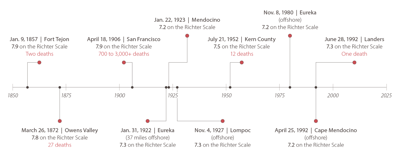
10 Strongest Earthquakes in California’s History
Following are the 10 strongest earthquakes (in terms of magnitude) in California’s history, as recently was reported by The Sacramento Bee. Others of note: Ridgecrest, Loma Prieta, Northridge, San Fernando.
Quake Readiness
How confident is Caltrans that its bridges are ready to meet the challenges of tomorrow’s big earthquakes? The Department’s veteran bridge engineers offered their thoughts.


Mark Mahan, Office Chief, Office of Earthquake Engineering Analysis and Research: “There is no such thing as taking the risk to zero. There is always a risk. But it should be minimized as much as possible. We are on that path. Before 1989, earthquake engineering knowledge was limited. Bridges carrying the truck loads were especially vulnerable to extreme earthquake damage. Improvements in seismic sciences since 1989 have empowered engineers to design resilient new bridges and retrofit the older ones.”
Erol Kaslan, Chief of Structure Investigations, North: “I think Caltrans as an organization has come a long way since Loma Prieta. We have our Office of Emergency Management. Each district now has their sub-office of managing those kind of things. There are protocols, there are things that are in place right now. We run random drills from time to time. So as an organization, we’re much, much better at being able to respond to these. But we can do more, including dedicated earthquake training.”
Brian Maroney, Toll Bridge Seismic Retrofit Chief Bridge Engineer: “There’s still going to be surprises. The reality is there will be earthquakes in the future in California. ... But we are going to perform, as a state, a lot better because of the investment that elected officials and the good taxpayers of California paid into. We have reduced risk, really tremendously, up and down the state.”
Ongoing Effort to Examine, Strengthen Bridges
Caltrans continually performs research and analysis to identify new information that will help fortify bridges, and protect travelers, when earthquakes strike.
Bridges are assessed for seismic vulnerability based on screenings performed by Caltrans’ Offices of Earthquake Engineering and Geotechnical Services. A detailed ranking and a priority list is then created, subject to further structural analysis to validate.
The assessments are based on anticipated ground motions and seismic movement generated by earthquakes of a certain strength. For bridges with foundations in or near a waterway, the potential for soil liquefaction is also evaluated.
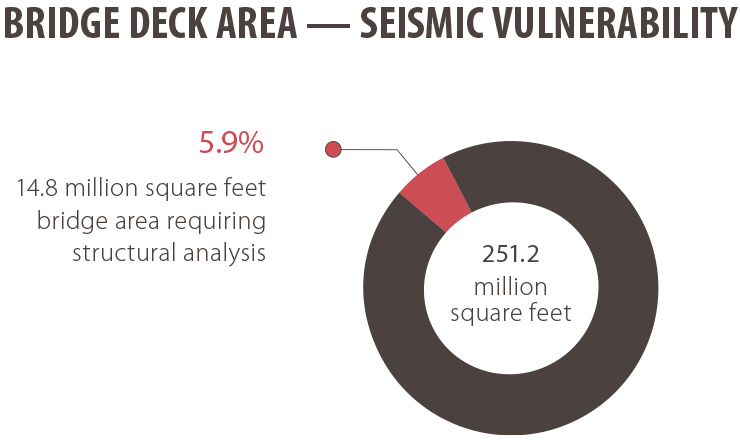
The Caltrans Asset Management group condenses the detailed seismic rankings and tallies the amount of total bridge deck area (in square feet) requiring further structural analysis.
Of Caltrans’ total bridge deck area of 251.2 million square feet statewide, about 14.8 million square feet may have some degree of seismic vulnerability.
Those bridges deemed potentially vulnerable are then prioritized for additional analysis to determine if seismic retrofitting is needed. All State Highway System bridges are included in this inventory, except Bay Area Toll Authority, Golden Gate Transportation District bridges, and bridges built and maintained under public-private partnerships.
In its 2019 State Highway Management Plan, Caltrans has set a goal to bring 70 percent all bridges in need of seismic strengthening (as measured by square feet) to a good condition rating by 2029. Caltrans estimates it will take $777 million in the next 10 years to improve almost five million square feet of bridge deck area.
Source: 2019 State Highway System Management Plan