
District 9 photo
By Christopher Andriessen
District 9 public information office chief
There was a pervasive feeling of disbelief in the offices of District 9 on Aug. 5, 2022, as pictures and videos came in from maintenance staff monitoring State Route 190 in Death Valley National Park.
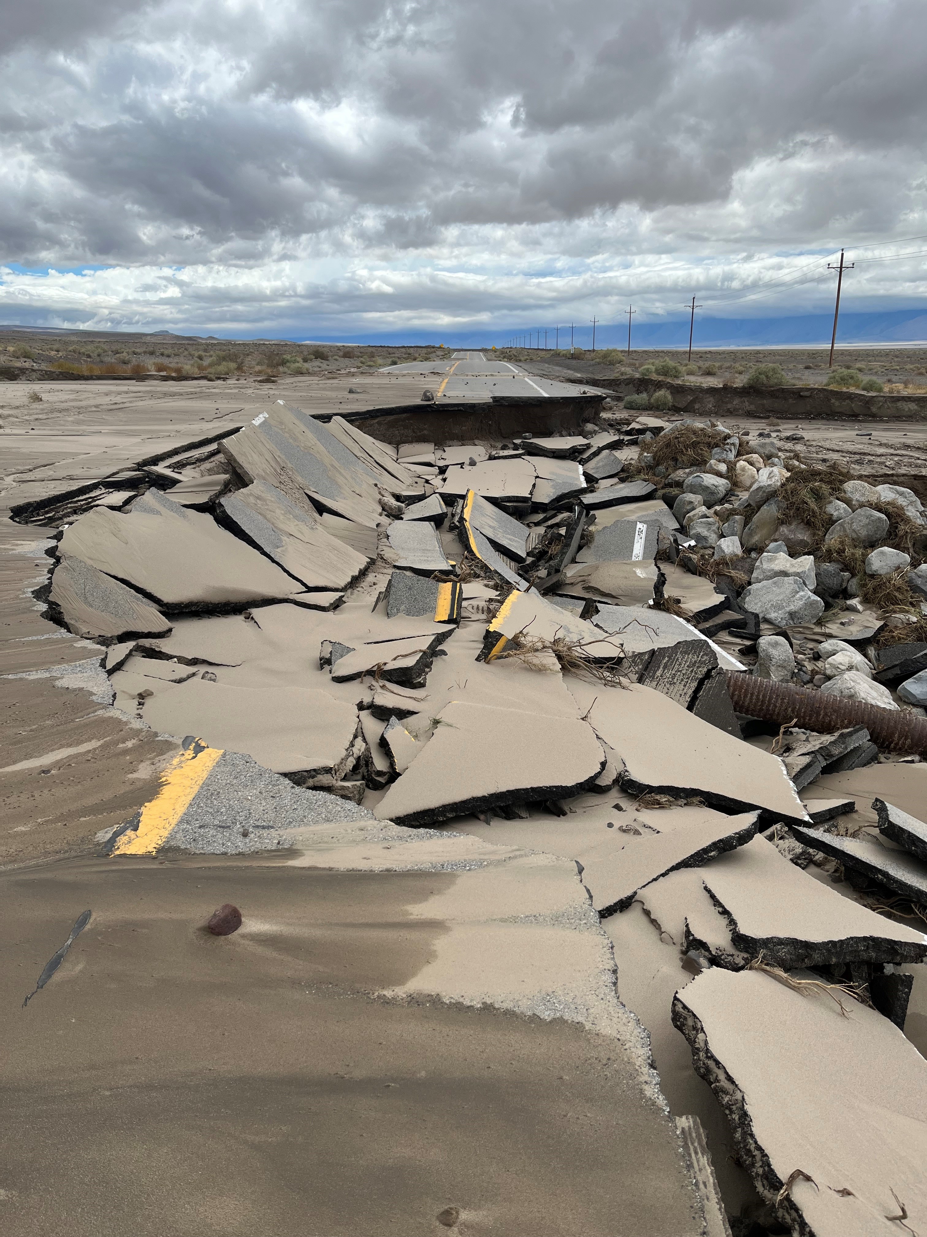
The driest place in North America, known for its unforgiving temperatures and expansive salt flats, was being inundated with water. Record rainfall turned the dusty landscape into debris flows, cascading over the highway and ripping up many park roads. West of the park, a section of State Route 190 known locally as Upper Centennial Wash was washed away.
Meteorologists called it a once-in-a-1,000-year event. That was, as already mentioned, in 2022. It would be just 380 days until the region would see another “once-in-a-1,000-year event.” Only this time, the damage would be far more extensive.
Tropical Storm Hilary made landfall on Aug. 20, 2023. That day, Death Valley National Park (DVNP) recorded a record 2.2 inches of rain, nearly 100 percent of its yearly average in a span of 24 hours. Like the previous summer, the record rain led to debris flows that washed away shoulders and tore up the highway.
The section of State Route 190 at Upper Centennial Wash that had been rebuilt the previous year was once again washed away. Segments of the highway over Towne Pass within DVNP broke apart and scattered with the flood waters.
District 9 photo
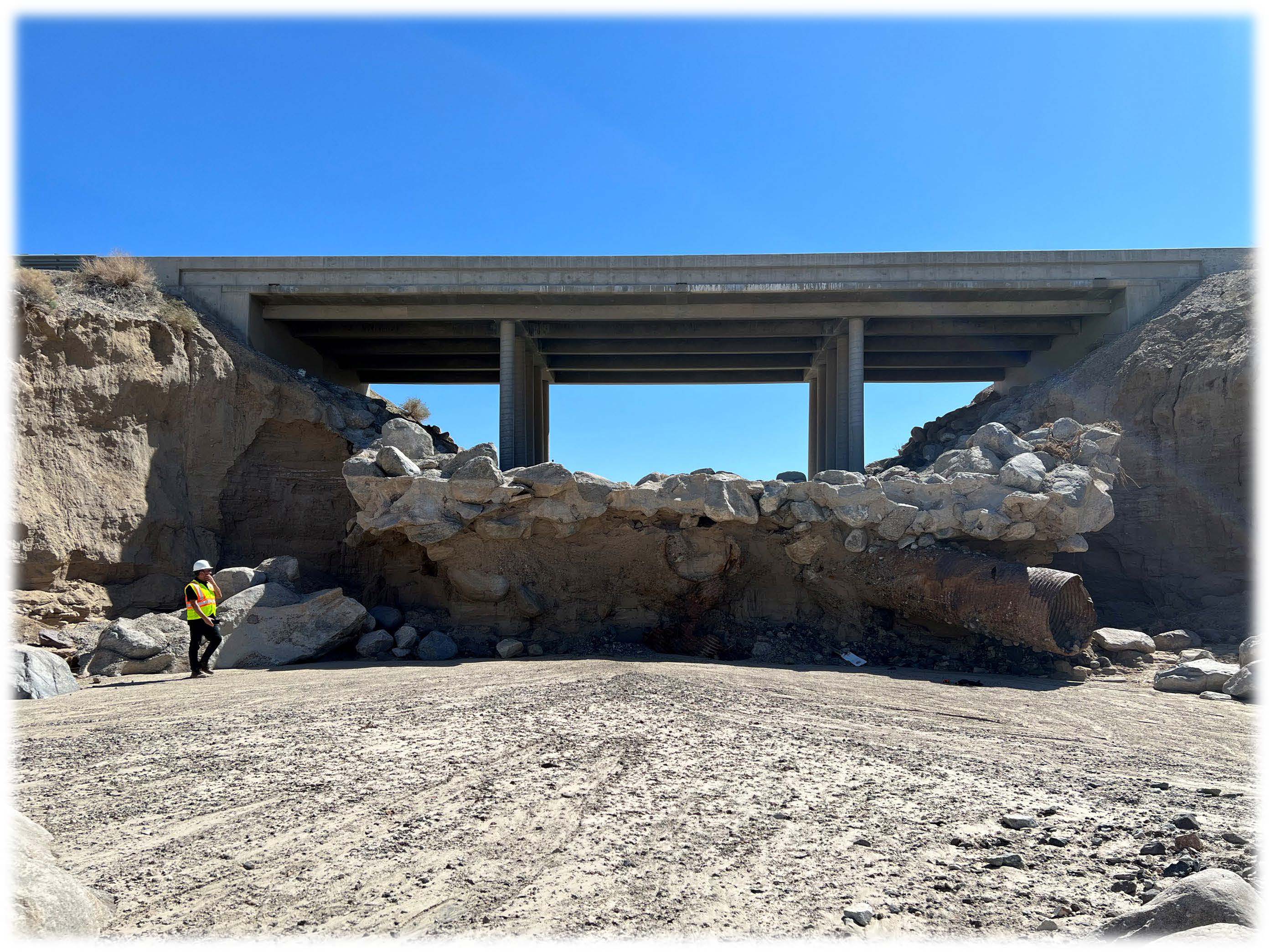
Farther west, along Owens Lake in an area known as Lower Centennial Wash, the storm undercut the roadway, displaced culverts, buckled the highway asphalt and impacted the Coso Wash Bridge (pictured).
Repair work began almost immediately, and access to the bulk of the highway was restored on Oct. 15. But with two record-breaking weather events in less than 400 days, along with the other significant storms that followed, simply restoring the roadway wasn’t enough. District 9 would need to make State Route 190 more resilient, more able to withstand Mother Nature.
To keep State Route 190 scenic while enhancing its climate resiliency, engineers elected to go with gabions—wire mesh baskets filled with rocks, sand and soil that blend into the surrounding environment—and concrete slope paving at strategic locations. These elements are designed to protect the roadway from the type of erosion it experienced with these storms.
Some of the locations that will see these climate improvements include popular tourist destinations within Death Valley, including Furnace Creek Inn, Zabriskie Point and Emigrant Campground.
District 9 photo
Outside of the park, gabion shoulder reinforcement will be implemented at Upper Centennial Wash. These climate resiliency elements for State Route 190 and more will go into construction after the Director’s Order Supplements that were drafted alongside the emergency work orders are approved by Caltrans Headquarters.
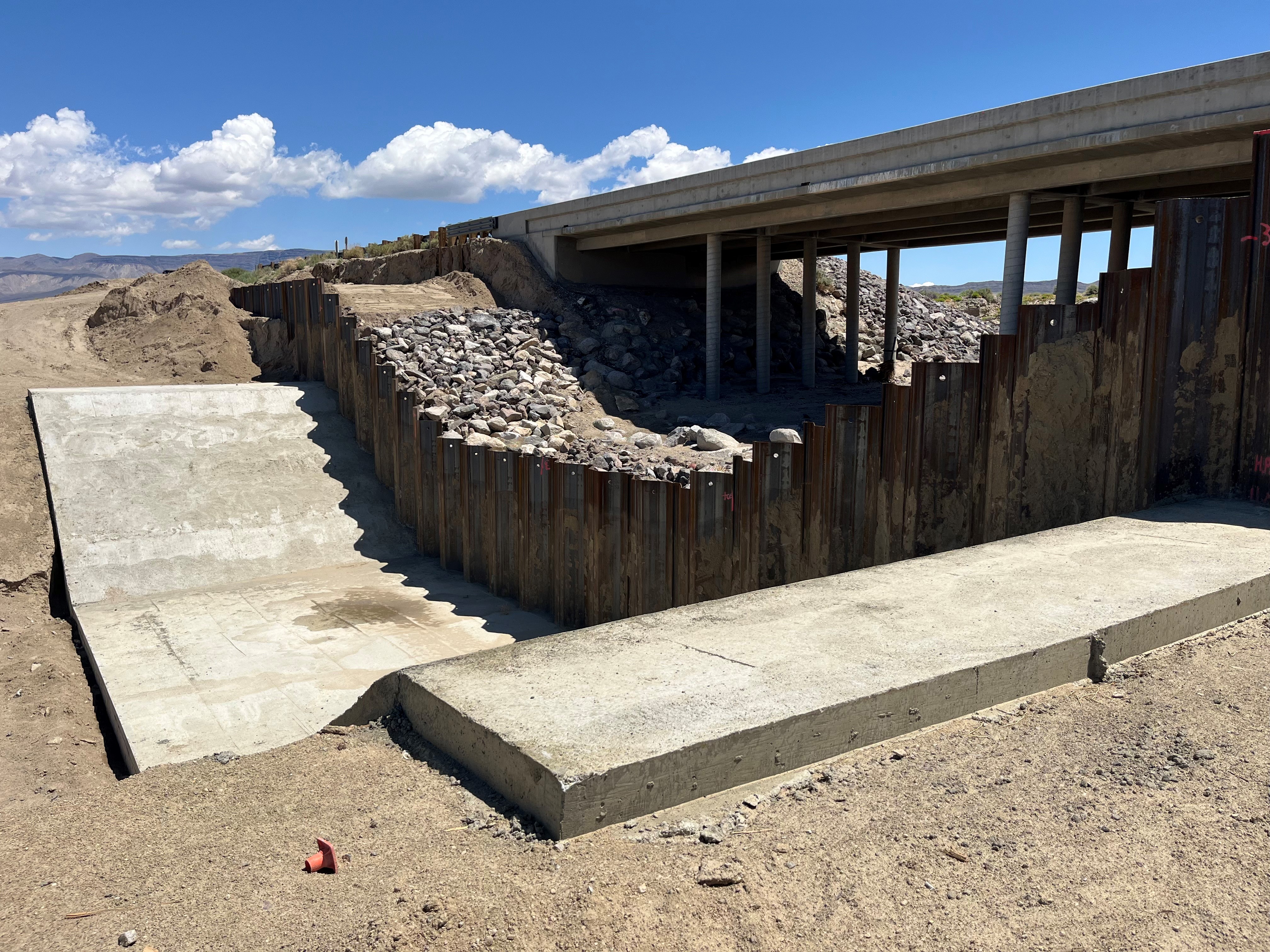
One piece of resiliency engineering was included in the original Director’s Order for Coso Wash Bridge. Hilary’s flood waters devastated the rock slope protection (RSP) that braced the bridge’s slim pillars. Rather than just repair the RSP as it did the year before, Caltrans sought an upgrade that would make the bridge far more resilient to erosion. The recommendation: a sheet pile check dam measuring approximately 150 feet wide and 36 feet tall, with the base driven 10 feet below the tip of the existing bridge piles. A 92-foot-long concrete slab with a 6-foot-high cutoff wall, native material backfill, and RSP would support the bridge structure.
According to Ali Ahmad Bahadori, a Caltrans transportation engineer who worked on the new facility’s design, the sheet pile check dam is a superior countermeasure over the original grouted RSP because it is embedded into the channel bed and banks, ensuring stability for the life of the structure. This is a considerable improvement over the grouted RSP that partially collapsed during the Hilary flooding.
Work at Lower Centennial didn’t begin until after repairs wrapped up at Upper Centennial and inside Death Valley National Park as Caltrans prioritized restoring highway access to isolated communities. The section of State Route 190 between the town of Olancha at U.S. Highway 395 and the junction of State Route 136 east of Owens Lake would remain closed throughout the winter and spring.
After months of roadway facility repairs and the construction of the new dam at Coso Wash Bridge, State Route 190 fully reopened in Inyo County on May 22, 2024. The dam stands out as a striking piece of hydraulic engineering among the dusty barrens that extend out of Owens Dry Lakebed, one that may become a blueprint for how Caltrans can protect its infrastructure from future climate change-driven superstorms.