
Vincent Thomas Bridge Frequently Asked Questions
PROJECT
1. What is the Vincent Thomas Bridge Deck Replacement Project?
The Vincent Thomas Bridge (VTB) was built in 1963 and has been in service for 60 years. Although the bridge is structurally sound, the bridge deck is rapidly deteriorating. This is due to concrete fatigue caused by heavy traffic loading, as well as environmental deterioration due to age and the marine environment. Caltrans is proposing to replace the entire bridge deck and its seismic sensors. In addition, the project will replace the bridge railings, fences and median barrier. The purpose of this project is to preserve the operations, functionality, and structural integrity of the bridge deck.
2. Where is the project located?
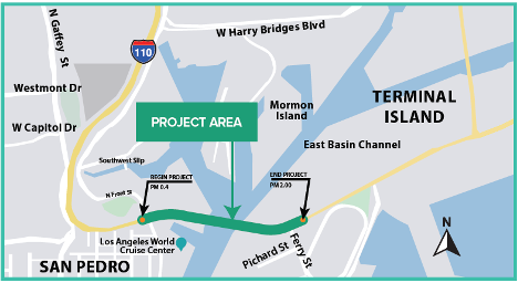
The project is on State Route 47 (SR 47) from post miles 0.4 to 2.0. The bridge provides a critical connection from the community of San Pedro to Terminal Island, the ports, and the City of Long Beach.
3. Why do we need this project?
The median barrier and bridge railing are not in compliance with the latest requirements for the federal Manual for Assessing Safety Hardware. If the current bridge deck of the VTB were to remain in place as is, and the entire bridge deck deterioration is not addressed, the structural integrity of the deck will continue to worsen and have more localized deck failures, which will require more frequent emergency bridge closures for repairs. The bridge deck has reached the end of its design life, and the deck replacement is the best available option. The project is needed to enhance the safety of the traveling public on the VTB and maintain an important economic corridor to Terminal Island.
4. What is the Build Alternative?
The Build Alternative with a Single Stage Construction (16 month full bridge closure) was selected. The Build Alternative proposes to replace the bridge deck of the VTB, the median concrete barrier, fences, guardrails and seismic sensors. The proposed improvements would ensure the safety of the traveling public on the VTB and provide a viable bridge deck that is designed to last many decades depending on the types of materials used and environmental factors. During construction, the anticipated detour routes will direct traffic to and from Terminal Island via the Commodore Schuyler F. Heim Bridge (SR 47) from the north and the Gerald Desmond Bridge (I-710) from the east. These potential detour routes include West Harry Bridges Boulevard, Alameda Street, and Henry Ford Avenue (SR 47).
5. How did Caltrans decide on the approved build alternative and timeframe for construction (16-month full closure of Vincent Thomas Bridge)?
Caltrans considered feedback regarding the various build alternatives from relevant agencies, neighborhood councils and the public during the project’s environmental phase. Based on that feedback process, and for reasons including safety, efficiency, and cost, Caltrans determined the best approach to this project would be a full bridge closure for a shorter period of time.
6. Who is leading the project?
Caltrans is leading the project and is the California Environmental Quality Act (CEQA) and National Environmental Policy Act (NEPA) lead agency preparing the Environmental Impact Report/Environmental Assessment to comply with CEQA/NEPA.
7. When will this project be complete?
The project is anticipated to start construction in late 2026, the bridge is anticipated to reopen to traffic before the 2028 Olympic Games. The project delivery milestones and schedule are depicted below.
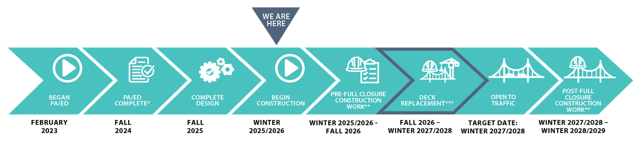
*PA/ED: Project Approval and Environmental Document
**Nightly one directional closures and possible weekend closures
*** Full closure (16 months)
8. Can Caltrans add a bike lane to Vincent Thomas Bridge during construction?
No, the purpose of the project is to replace the deteriorating bridge deck. The design and structure will stay the same, and capacity on the bridge will not be increased. The deck area can only accommodate two travel lanes in each direction with no room left for any bike/pedestrian lanes. According to the Southern California Association of Governments regional bicycle dataset, there are plans for a Class IV protected bikeway to be located somewhere between the Vincent Thomas Bridge and the Long Beach International Gateway Bridge. The location of the existing Class I Bike Lane along I-710 in the POLB (Mark Bixby Memorial Bike Path) was added to Figure 2.10-8 in the Final EIR/EA.
9. Could a ferry service be operated in the harbor temporarily to transport people and vehicles throughout the construction phase?
Caltrans met with the Port of Los Angeles regarding numerous mitigation measures to alleviate traffic congestion to Terminal Island due to closures of the Vincent Thomas Bridge. One measure that was discussed was a ferry service that would run from San Pedro to Terminal Island during closures of the Bridge, similar to the service that was in place prior to the Vincent Thomas Bridge’s completion in 1963. The Port of Los Angeles determined that a ferry service would be infeasible for numerous reasons including regulatory concerns of ferries crossing the Main Channel of the POLA interfering with other port traffic, the need to construct and operate points of origin and destination for ferries, acquisition of ferries, and the hiring ferry operators. Parking infrastructure would also be required for ferry patrons.
10. How can the public contact Caltrans regarding concerns with this project?
Public Information Officers (PIOs) Diana Jimenez and Nathan Bass may receive public inquiries about the Vincent Thomas Bridge Deck Replacement Project. PIOs monitor the vtbproject@dot.ca.gov inbox daily and provide comprehensive responses to public inquiries.
TRAFFIC MANAGEMENT PLAN (TMP)
1. What is the Traffic Management Plan (TMP)?
The Traffic Management Plan (TMP) will designate the detour route(s) to be utilized during construction, as well as strategies to control and minimize traffic during the bridge closure. The TMP and detour routes will potentially change during project construction to respond to real-time conditions and feedback from the community and stakeholders. The TMP will be developed in coordination with local agencies and project stakeholders in the Design and Construction phases of the project.
2. What was the TMP Task Force?
Caltrans invited agencies, stakeholders, elected officials and members of the public to join the Traffic Management Plan (TMP) Task Force. The Task Force gathered public input from stakeholders and motorists regarding the development of detour routes, communications strategies, and traffic control programs to be implemented during the bridge’s forthcoming closure. Task Force meetings were held in late 2024 to early 2025. View TMP Task Force meeting records at the project website.
3. Is Caltrans aware of other infrastructure projects in the area that could complicate the Traffic Management Plan? How will other infrastructure projects in the area complicate the Traffic Management Plan?
Numerous roadway and utility capital improvement projects are planned or currently underway throughout the project area. Caltrans has taken account of these projects, and the department is coordinating with the local jurisdictional agencies responsible for them to mitigate potential traffic impacts in the Vincent Thomas Bridge area.
Caltrans is aware there could be projects in construction during the timeframe of the VTB project (late 2026 to mid-2028) on some of the proposed detour routes. The City of Los Angeles has elected to postpone its Alameda South Widening project until after the deck replacement, allowing for optimal traffic flow during the 16-month bridge closure.
5. How will you address traffic congestion during construction?
Caltrans will utilize a multitude of communication strategies, including the deployment of dozens of highway signs throughout the region, to divert away from the bridge and other impacted areas. The department and local partners will also coordinate a surge of traffic control and enforcement at key locations in the project area during construction. Additionally, the reconfiguration of lanes and traffic signal timing along the detour route is under consideration as congestion-relieving measures.
6. What are the detour routes for this project?
While the official detours have yet to be determined, Caltrans aims to divert detour traffic, particularly commercial trucks, away from city streets and toward the freeway system.
7. Will there be increased law enforcement along proposed detour routes?
Yes, Caltrans is closely coordinating with state and local law enforcement agencies to enhance local traffic enforcement capabilities during the 16-month full closure of Vincent Thomas Bridge.
8. Will Caltrans repave streets deteriorated by traffic diverted from the project area?
The local streets are under local agencies’ jurisdiction; however, Caltrans will partner with local transportation agencies to seek opportunities for repairing designated detour routes. Work on roads outside the Caltrans right-of-way would be contingent on approval by all respective local agencies.
9. Will my child be late to and from school?
Caltrans anticipates minimal traffic impacts to schools in the project area, especially the K-12 facilities located along PCH (State Route 1) since PCH is not expected to be a designated detour route during construction on Vincent Thomas Bridge. Regardless, Caltrans is working closely with the Los Angeles Unified School District to facilitate school bus entry and exit at schools, where impacted.
10. Will the Traffic Management Plan evolve to address issues in the detour routes?
The Traffic Management Plan can change to accommodate significant deficiencies in the designated detour routes.
11. Will the Traffic Management Plan be enforced?
The Traffic Management Plan will not be a legally enforceable document; however, local ordinances restrict the operation of commercial trucks in locations throughout the project area. Law enforcement partners, including the California Highway Patrol and the Los Angeles Police Department, will be crucial in the enforcement of those ordinances. Law enforcement agencies are actively participating in the Traffic Management Plan Task Force, which is developing detour routes for the project, and they will be aware of anticipated disruptions to regular traffic flows in the area. There will be multi-jurisdictional coordination on enforcement that will be developed as well as part of the TMP.
12. Will you work with the truck distribution operators to ensure that they follow
detours?
Trucking and terminal operators at the port will be involved in developing the Traffic Management Plan with the understanding that drivers will be notified of the designated detour routes and expected to follow them. Law enforcement agencies are responsible for citing violations of ordinances restricting the operation of commercial trucks in designated areas. There will be multi-jurisdictional coordination on enforcement that will be developed as well as part of the TMP.
13. Will Caltrans preemptively notify motorists outside of the project area about the bridge closure?
Because of the significant traffic impacts anticipated with the full bridge closure, Caltrans will utilize numerous outreach methods to notify motorists throughout the region of the forthcoming closure before construction begins. For example, Caltrans will display notices of the closure on electronic message boards throughout Los Angeles, Orange, and San Bernardino counties in the months preceding construction. Caltrans will also use paid advertising, social media and outreach to news media to notify motorists.
14. Is Caltrans coordinating with the railroad operators at the ports?
Caltrans is actively coordinating with railroad authorities, including the Alameda Corridor Transportation Authority and the Port of Los Angeles, to identify traffic mitigation strategies for this project, such as signal coordination at railroad crossings.
15. Could road diet measures along local streets, such as bike lanes, be temporarily removed during the closure?
The removal of road diet measures installed on streets within the City of Los Angeles’ jurisdiction would require approval and action by the City. The City has previously stated a willingness to explore the temporary removal of road diet measures within the region but noted such action could violate the terms of the Safe Streets for All Grant funding originally utilized to install them.
16. Has Caltrans considered project-related traffic impacts west of Interstate 110?
Caltrans will continue its effort to address potential traffic impacts throughout the project area, including in areas west of Interstate 110, during development and throughout execution of the Traffic Management Plan.
17. Does Caltrans operate cameras to monitor traffic within the project area?
Caltrans operates 17 CCTV cameras within the project area. Live video feed from those cameras is publicly accessible, however, functionality of the cameras may be compromised due to vandalism or technical failures. Public access to video feed generated from Caltrans’ statewide CCTV network is available online. Caltrans is in the process of restoring the full functionality of its CCTV network.
18. Has Caltrans taken account of how the bridge closure and project-related traffic could impact emergency services?
Caltrans is coordinating with the City of Los Angeles Emergency Management Department to ensure first responders are aware of the project and prepared to respond to emergencies during the period in which Vincent Thomas Bridge is closed for construction.
19. Will Caltrans continue its outreach during the bridge closure?
Caltrans will continue its public outreach and local agency coordination efforts throughout the project, including during construction. If that outreach reveals significant deficiencies in the designated detour routes, the Traffic Management Plan will be revised to correct them.
20. Could Caltrans create a mobile application to assist motorists in planning their commutes in and around the project area?
Caltrans maintains a mobile application for its QuickMap resource, which details real time incident information, such as lane closures and roadway maintenance. Public access to video feed generated from Caltrans’ statewide CCTV network is available online. Caltrans also aims to integrate the City of Los Angeles’ live video feed into its Traffic Management Center to make video available for motorists and the news media.
21. Could public transportation circulation be increased during the bridge closure to alleviate car traffic?
Caltrans will continue coordinating with Los Angeles County Metropolitan Transportation Authority and other transit operators as it explores opportunities to expand public transportation and reduce car traffic in the project area.
22. Has Caltrans studied the volume of commercial trucks within the project area?
Caltrans conducts an annual study on truck traffic statewide, and the most recent data is provided in the 2022 Truck Annual Average Daily Traffic (AADT) dataset. This study relies on electronic counting instruments to collect detailed information on truck traffic, capable of detecting various truck sizes. The 2022 dataset is available online for public access. AADT dataset
23. Can you ensure that there will be more enforcement of traffic laws?
Caltrans is working with the California Highway Patrol (CHP), Los Angeles Police Department (LAPD) and Los Angeles Port Police on traffic management and traffic safety during the closure. These agencies are part of the Traffic Management Plan Task Force as well. We understand there is concern now about motorists’ behavior prior to the bridge closure. We are conveying those concerns to each agency. CHP has indicated that they will monitor the intersections of concern.
24. How can we ensure that major intersections flow smoothly on the detours?
Caltrans is coordinating with local agencies, such as the Los Angeles Department of Transportation, to deploy Traffic Control Officers at key intersections during the 16-month bridge closure. Additionally, the timing of traffic signals at anticipated chokepoints may be adjusted to facilitate smoother traffic flows.
25. How can we make sure our children are safe around schools that may have increased traffic?
Together with the Los Angeles Unified School District and Los Angeles Department of Transportation, Caltrans is exploring whether more crossing guards may be deployed in areas impacted by the designated detour routes. The detour routes presently under consideration avoid schools with Pre-K through 12th grade populations.
26. Aggressive driving linked to the Covid pandemic has persisted since the pandemic’s end, and the bridge closure could exacerbate this trend. How are you going to change driver behavior?
Caltrans will work with law enforcement agencies to address traffic law violations. Caltrans will also include driver behavior messaging in its outreach before and during the project construction.
CONSTRUCTION
1. How is this project funded?
Currently, the project is funded by the State Highway Operation and Protection Program (SHOPP). The project will be subject to a full reimbursement from the federal Infrastructure Investment and Jobs Act (IIJA) if the scheduled construction and project delivery completion deadlines are met. Caltrans will continue to work collaboratively with project stakeholders so the region will not lose the funding for this critical project.
2. When will construction begin?
Construction is anticipated to start in the late 2026.
3. Will crews be working 24 hours a day to get this done?
Yes, crews will be working on the project around the clock to complete the project. The calculation of a 16-month full closure schedule is based on a 24-hour workday.
4. How will you notify the public of construction and detour routes?
Multiple channels will be utilized to notify the public, such as, but not limited to, press releases, social media, mailers sent to residents and businesses, newspaper and radio advertisements, ample signage, and changeable message signs. Caltrans will closely coordinate with the advisory committees to collaborate on engagement to notify the community and stakeholders. Notification to the public will continue prior to and during construction.
5. Will this project overlap with the Olympics?
The project is scheduled for completion before the 2028 Olympics.
6. Can Caltrans provide a list of our vendors and general contractor?
The general contractor and subcontractors will be identified after design of the project is complete and the construction contract is awarded. This project is being delivered via the Construction Manager/ General Contractor (CM/GC) delivery method. Throughout the current project phase (design), Caltrans will prepare and share project plans and specifications with the CM/GC. Caltrans and the CM/GC will collaboratively develop and finalize the construction schedule while considering areas where the schedule can be accelerated. Caltrans and the CM/GC will then negotiate toward an agreed price for construction based on the agreed construction schedule. Upon reaching an agreed price, the CM/GC will become the General Contractor responsible for the constructing the project. If Caltrans and the CM/GC do not reach an agreed price for the final construction contract, the project will be advertised, awarded, and approved using conventional processes. Skanska-CEC Joint Venture is currently the CM/GC for the project, which has not yet reached the construction phase.
7. Will this project utilize incentives to encourage faster construction?
With the contracting model being used for this project (CM/GC Delivery Program), Caltrans does not intend to utilize construction incentives as this model incorporates shorter time frames for construction and a negotiated price. Caltrans and the CM/GC will collaboratively identify construction challenges and opportunities for acceleration prior to construction. The current construction schedule, including the planned 16-month full bridge closure, represents the shortest construction timeline known to both Caltrans and CM/GC at this time. Caltrans will continue working with the CM/GC throughout the project design phase to shorten construction and the full bridge closure even further.
8. Will a penalty be charged to the construction contractor if the project is not completed on time?
Caltrans may recuperate damages from the general contractor if the project, including all administrative tasks, is completed late due to faults of the contractor. The construction schedule, based on a 24-hour workday, will be subject to a contractual agreement between Caltrans and the General Contractor selected for the project. The contractor will be liable for delays in the final completion of the project through processes known as “liquidated damages” and “time-related overhead,” which are described in Chapter 3 of the Caltrans Construction Manual. Beyond the liquidated damages, Caltrans is exploring the implementation of disincentives to discourage any extension of the full bridge closure beyond the 16-month period.
AVOIDANCE AND MINIMIZATION
1. What process do you have for potential loss of revenue for the local businesses during construction?
If a business owner believes they have experienced a loss of revenue due to the project, the owner will have the option to submit a claim. For questions about claims related to incidents that occurred within Los Angeles or Ventura counties, please call (213) 897-0816.
2. Will this project impact the goods movement with the ports?
Caltrans will be coordinating with both ports to minimize impacts to the extent feasible.
ENVIRONMENTAL
1. What is CEQA/NEPA?
The National Environmental Policy Act (NEPA) was signed into law in 1970 and established national environmental policy and goals for the protection, maintenance, and enhancement of the environment. NEPA provides a decision-making process for federal agencies to assess the environmental effects of projects that involve federal funding, work performed by the federal government, or permits issued by a federal agency. The California Environmental Quality Act (CEQA) was also signed into law in 1970. CEQA requires state and local agencies to analyze and disclose the environmental impacts of proposed projects and to adopt all possible measures to avoid or mitigate those impacts.
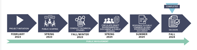
2. What is and where are we in the environmental phase?
Caltrans is the California Environmental Quality Act (CEQA) and National Environmental Policy Act (NEPA) lead agency. The environmental phase was completed Fall 2024 and a Preferred Alternative was selected. The Final Environmental Impact Report (EIR) / Environmental Assessment (EA) was released in October 2024 and is available on the Caltrans and project website at:

3. Is additional right-of-way needed for this project?
No property acquisition or relocations are required for this project. Temporary easements near the project may be needed during construction for staging equipment and access.
4. How can I provide feedback or comment on this project?
Members of the public and stakeholders are encouraged to provide feedback through:
• Project website: virtualeventroom.com/caltrans/vtb/
• Email: VTBproject@dot.ca.gov
• Public or virtual engagement activities (more information on the project website)
• Diana Jimenez, Public Information Officer, District 7 (213) 500-7301
• Nathan Bass, Public Information Officer, District 7 (213) 269-0687
5. What is a Community Advisory Committee?
To better engage with the community, understand their concerns and collaborate to minimize project related impacts, Caltrans has formed the Community Advisory Committee for the VTB project. The advisory committee includes representatives from multiple neighborhood councils, local chambers of commerce, councils of government, school district, and multiple unions, business-related organizations and other community-based entities. In addition, the committee meetings are attended by elected officials or their representatives. For transparency, the monthly Community Advisory Committee meetings are recorded and posted for public review on the project website. Additionally, members from the Community Advisory Committee attend the Technical Advisory Committee meetings to further promote collaboration and transparency between the committees.
6. What is a Technical Advisory Committee?
To engage with subject matter and technical experts in obtaining multi-jurisdictional expertise to address key concerns, discuss timing of adjacent or concurrent projects, develop collaborative strategies to ensure safety, to minimize project related impacts, and address concerns from the Community Advisory Committee, Caltrans has formed the Technical Advisory Committee for the VTB project. The task of the Technical Advisory Committee is to provide technical expertise, solutions and strategies to the Caltrans design team. The advisory committee includes representatives from multiple agencies of various levels of government likely to be affected by the project, such as cities, the county, public works agencies, councils of government, law enforcement, and the ports. In addition, the committee meetings are attended by elected officials or their representatives. For transparency, the monthly Technical Advisory Committee meetings are recorded and posted for public review on the project website. Additionally, members from the Technical Advisory Committee attend the Community Advisory Committee meetings to further promote collaboration and transparency between the committees.
7. How will Caltrans address concerns about increased emissions related to the project?
Caltrans will continue to coordinate with the South Coast Air Quality Management District (SCAQMD), California Air Resources Board (CARB), and other agencies to explore potential strategies as part of the Wilmington, West Long Beach, Carson AB 617 Community Emissions Reduction Plan (CERP) to minimize air quality impacts. Caltrans will also continue coordinating with SCAQMD and local stakeholders to ensure the CERP is followed during construction and keep the community informed about progress and actions taken.