
Improve Traffic Operations at SR 37/121 Intersection
Fact Sheet
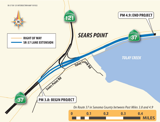
04-Son- PM 3.8/4.3 EA 2Q20U*
* This project is being combined with EA 1Q763, Tolay Creek Bridge Replacement
Project Description
The project will improve operations at the intersection of SR 37 and SR 121 in Sonoma County (Son). SR 37 is a four-lane Expressway to the west of this intersection and a two-lane Conventional Highway to the east of the intersection. Five Build Alternatives and the No-Build Alternative are proposed for study in the current project delivery phase to determine the Preferred Alternative for project approval and Environmental Document clearance.
Purpose and Need
The purpose of the project is to improve vehicular operations and reduce delay at the SR 37 / SR 121 intersection. The objective of the project is to provide operational improvements at the intersection, including improving peak-hour travel times, reducing daily vehicle hours of delay, and shortening the queue on eastbound SR 37 during peak hours.
The project is needed because operational conditions at the intersection have been deteriorating due to increased traffic volumes. Heavy congestion occurs in the eastbound direction of SR 37 and creates a queue that backs up into the four-way signalized intersection at SR 37 and SR 121 during peak hours and events. The queue, which is caused in part by the lane drop in the eastbound direction of SR 37, decreases the functionality of the intersection of SR 37 and SR 121. Motorists driving east on SR 37 may experience approximately 45-minute delays traveling through the intersection during the peak-hour period due to the lane drop east of the intersection.
Selected Build Alternative
Under this alternative, the SR 37 eastbound lane drop will be relocated from its current location east of the intersection of SR 37 / SR 121 at PM 3.92 to PM 4.92. The 1-mile lane drop extension alternative will lengthen the eastbound two-lane section by 1 mile. No changes will be made to the existing SR 37 / SR 121 four-way signalized intersection. In extending the lane drop, Alternative 4 will widen the highway until 1 mile east of the intersection, replace Tolay Creek Bridge, and extend and/or replace the existing median barrier.
Schedule
Complete Environmental Phase – February 8, 2023
Complete Design – Spring 2026
Begin Construction – Fall 2026
End Construction – Winter 2029