
State Route 37: Sears Point to Mare Island Improvement Project
Project Description
The Project is to improve traffic flow and peak travel times and increase vehicle occupancy (number of people moved per vehicle) in the SR 37 corridor. It proposes improvements at the existing roadway elevation to provide additional capacity during peak periods to improve traffic flow while minimizing environmental impacts. However, the Project does not address sea level rise (SLR). A future project, one that is commonly referred to as the Resilient 37 Project, will construct a new four-lane elevated facility built partly on fill and/or a causeway.
Purpose and Need
The purpose of the Project is to improve traffic flow and peak travel times and increase vehicle occupancy (number of people moved per vehicle) in the SR 37 corridor between SR 121 and the Mare Island interchange.
The Project is needed to address recurring congestion in the near term on SR 37, where the highway narrows to one lane in each direction between SR 121 and the Mare Island interchange. Capacity and merging constraints at present result in traffic queueing at the SR 37 / SR 121 intersection. Current demand and anticipated future transportation demand contribute to the need for this Project.
Selected Build Alternative
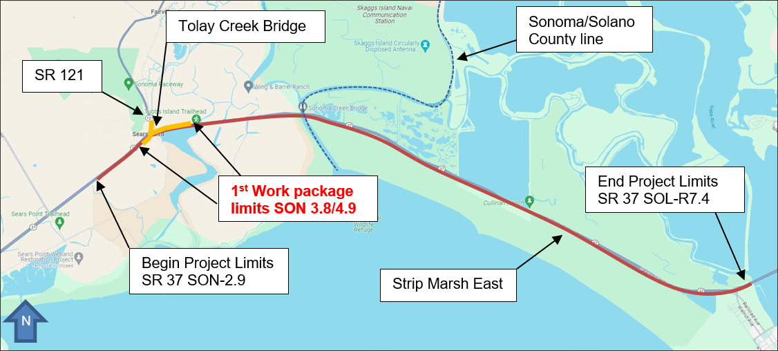
The Preferred Alternative will reconfigure the existing SR 37 highway lanes from west of the SR 121 intersection to the Walnut Avenue Overcrossing at Mare Island; would replace the Tolay Creek Bridge; have four lanes, with two full-time lanes in each direction; have 8-foot shoulders (except at Sonoma Creek Bridge, which would have 4-foot shoulders); would require widening the Sonoma Creek Bridge; and signalize SR 37/Noble Road intersection. The preferred alternative would introduce the eastbound HOV lane at the SR 121/SR 37 intersection vicinity, with the HOV lane on the left side, about 0.6 mile west of SR 121, and extend the eastbound left-turn lane approximately 0.5 mile west. The westbound HOV lane on the left side will commence at Mare Island Interchange.
The project intends to phase the project into work packages. The first work package will make operational improvements to the SR-37/121 intersection, replace the Tolay Creek Bridge, and extend the SR-37 EB merge lane from the intersection for a mile. The second work package will complete the extent of the HOV widening scope from the selected alternative and restore the adjacent Strip Marsh East area.
Schedule
Complete Environmental Phase – February 8, 2023
Complete Design – Summer 2026
Begin Construction – Spring 2027
End Construction – Fall 2029