
Section 5.9 – Agricultural Resources
5.9.1 Agricultural Resources in the Corridor
Agricultural resources in the North Coast Corridor (NCC) consist of various types of farmland as defined by the California Department of Conservation, Division of Land Resource Protection, and the U.S. Department of Agriculture (USDA) Natural Resources Conservation Service (NRCS). They are accessed and mapped statewide on an ongoing and regular basis and are defined as follows:
- Prime Farmland is defined as land that has been used for irrigated agricultural production at some time during the four years prior to the Important Farmland Map date. In addition, Prime Farmland must also meet the physical and chemical criteria as determined by the NRCS.
- Farmland of Statewide Importance is land other than Prime Farmland that has a good combination of physical and chemical characteristics for the production of crops. It may have been used for the production of irrigated crops at some time during the two update cycles prior to the mapping date.
- Unique Farmland is defined as land that does not meet the criteria for Prime Farmland or Farmland of Statewide Importance, but the land that has been used for the production of specific high economic value crops at some time during the two update cycles prior to the mapping date. This land has the special combination of soil quality, location, growing season, and moisture supply needed to produce sustained, high quality and/or high yields of a specific crop when treated and managed according to certain farming methods.
- Farmland of Local Importance is categorized as land that is either producing crops, has the capability of producing crops, or is used for the production of confined livestock, and may be important to the local economy due to its productivity or value. Furthermore, other agricultural lands are designated as such if they are subject to the Williamson Act contract or agriculture preserve.
In accordance with prime agricultural land standards per Coastal Act Section 30241, farmland within the Coastal Zone must meet any of the following in order to be defined as prime agricultural land:
- soil classification (Class I or II soils as defined by the NRCS);
- Storie Index Rating of 80 through 100;
- ability to support livestock (at least one animal unit per acre as defined by the USDA); or
- planted with fruit- or nut-bearing trees, vines, bushes, or crops that have a nonbearing period of fewer than five years and that will normally return during the commercial bearing period on an annual basis from the production of unprocessed agricultural plant production not less than $200 per acre. For purposes of this PWP/TREP analysis, the term "prime agricultural land" refers to those resources within the NCC that meet Coastal Act standards only.
Even if the land does not meet the prime agricultural land definition pursuant to Coastal Act Section 30241, Section 30242 protects all other agricultural lands suitable for agricultural uses and prohibits their conversion to nonagricultural uses unless agricultural use is not feasible or conversion would preserve prime agricultural land or concentrate development in existing developed areas.
While there are larger tracts of land in northern San Diego County that support a significant agricultural economy and agricultural resources, overall, agricultural operations in San Diego County tend to be smaller than elsewhere in California. The trend in San Diego County is smaller farms or smaller acreages for production. In 1992, 65% of the farms in San Diego County were smaller than 9 acres, which was significantly less than the statewide average farm size of 373 acres.1 In 2008, that percentage had increased to 68%.2 Agriculturalists in San Diego have specialized in producing agricultural products in a relatively urbanized area by growing high-dollar-value per-acre crops such as nursery and greenhouse crops. Within the corridor, the agricultural parcels are relatively isolated areas supporting agricultural activities that are, for the most part, surrounded by various urban uses and open space areas in keeping with the overall agricultural trend in the county. Agricultural lands in the corridor generally occur adjacent to lagoon areas and associated open space, and in various patches throughout the otherwise urban landscape.
A majority of agricultural lands in the corridor–particularly in Carlsbad, Encinitas, and Solana Beach– consist of nursery and greenhouse operations. These types of agriculture are relatively unaffected by typical urban/agricultural interface issues and encroachment. Because the cultivation occurs in structures and in pots not soils, it is the coastal climate that provides the resource and benefit to these types of agricultural commodities as opposed to cultivated land.
5.9.1.1 LOSSAN Rail Corridor Resources
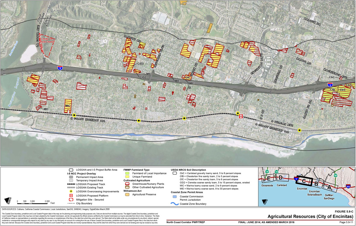
The LOSSAN Final Program EIR/EIS (September 2007) for the LOSSAN rail corridor improvements indicates that there are some agricultural lands within the LOSSAN rail corridor near Oceanside, which include Prime Farmlands and Farmlands of Local Importance. A number of properties designated as Unique Farmland, and some lands that are not designated but are under active cultivation (greenhouses/nursery plants), are located adjacent to and east of the rail corridor in Encinitas, just south of Batiquitos Lagoon (Figure 5.9-1C). An additional site that is not designated but is also under active cultivation (greenhouses/nursery plants) is located adjacent to and west of the rail corridor in Carlsbad, south of Agua Hedionda Lagoon (Figure 5.9-1D).
5.9.1.2 I-5 Highway Corridor Resources
A Community Impact Assessment, dated October 2007, was used to prepare the I-5 NCC Project Final EIR/EIS (October 2013) to identify existing agricultural resources and potential project impacts to agricultural resources. For the purposes of analyzing potential impacts to agricultural resources, the study area encompassed a 0.5-mile radius from the centerline of the existing I-5 highway, and agricultural resources were assessed for each of the cities. In addition, mapping and assessment of the underlying NRCS soil classifications, including Storie Index Rating were conducted to determine if any agricultural resource parcels potentially affected by the PWP/TREP also meet the Coastal Act standards for prime agricultural land (Table 5.9-1).
San Diego
A limited amount of agricultural activity occurs within San Diego, the majority of which is located within the northern and eastern parts of the city. The southernmost portion of a parcel used for agricultural production and designated as Farmland of Statewide Importance is located directly adjacent to and east of the highway, south of San Dieguito Lagoon in the North City Future Urbanizing Area Framework Plan area (Figure 5.9-1A). This parcel does not, however, meet the Coastal Act standards for prime agricultural land.
Table 5.9-1: Coastal Act Agricultural Resource Designations and Project Impacts by Parcel
City of San Diego
No agricultural parcels located within I-5 or LOSSAN area of potential effect.
City of Del Mar
No agricultural parcels located within I-5 or LOSSAN area of potential effect.
City of Solana Beach
No agricultural parcels located within I-5 or LOSSAN area of potential effect.
City of Encinitas
| Parcel Description (Total Acreage) | Active Agriculture/ Irrigation | FMMP Farmland Type | Soil Classification | Storie Index Rating | Totals by Soil Type (Acreage) | Livestock Grazing | Fruit or Nut-Bearing Crops/Annual Gross Value per Acre | Surrounded by or on Periphery of Urban Uses | Project Impact Totals |
|---|---|---|---|---|---|---|---|---|---|
| Manchester strawberry/ flower fields (30.5 acres). | Yes; cultivated strawberry/Asian vegetables. | Prime Farmland, if irrigated. | Class III CsC: Corralitos loamy sand, 2 to 5 percent slopes. |
61 (Grade 3). | 30.5 acres | No | Potential | Bounded by residential uses to north and east, Manchester Ave and San Elijo Lagoon to south, and I-5 to west. | 6.9 acres |
| Pacific Verde Nursery (3.5 acres). | Yes; greenhouse/ nursery. | Unique Farmland. | Class IV CfC: Chesterton fine sandy loam, 5 to 9 percent slopes. |
32 (Grade 4). | 2.9 acres | No | No | East of and adjacent to I-5 at Union Street; other greenhouse/ nursery and residential uses to east, north and south | 0.2 acres |
| Pacific Verde Nursery (3.5 acres). | Yes; greenhouse/ nursery. | Unique Farmland. | Class IV MIE: Marina loamy coarse sand, 9 to 30 percent slopes. |
45 (Grade 3). | 0.05 acres | No | No | East of and adjacent to I-5 at Union Street; other greenhouse/ nursery and residential uses to east, north and south | 0.2 acres |
| Pacific Verde Nursery (3.5 acres). | Yes; greenhouse/ nursery. | Unique Farmland. | Unclassified. | N/A | 0.55 acres | N/A | N/A | East of and adjacent to I-5 at Union Street; other greenhouse/ nursery and residential uses to east, north and south | 0.2 acres |
| Greenhouse (0.7 acres). | Yes; greenhouse. | Urban. | Class III CbC: Carlsbad gravelly loamy sand, 5 to 9 percent slopes. |
21 (Grade 4). | 0.7 acres | No | Potential | Adjacent I-5 to east, west of Mackinnon Ave residential uses. | No impact |
| Greenhouse (0.7 acres). | Yes; greenhouse. | Urban. | Class IV MIE: Marina loamy coarse sand, 9 to 30 percent slopes. |
45 (Grade 3). | 0.7 acres | No | No | East of and adjacent to I-5, north of Puebla St and Poinsettia Park residential uses. | No impact |
| Weidner’s Gardens (0.91 acre). | Yes; greenhouse/ nursery. | Unique Farmland. | Class VI CID2: Cieneba coarse sandy loam, 5 to 15 percent slopes, eroded. |
16 (Grade 5). | 0.9 acres | No | No | Adjacent to the east side of I-5 and north of Leucadia Blvd. | No impact |
| Weidner’s Gardens (0.91 acre). | Yes; greenhouse/ nursery. | Unique Farmland. | Class IV MIE: Marina loamy coarse sand, 9 to 30 percent slopes. |
45 (Grade 3). | 0.01 acres | No | No | Adjacent to the east side of I-5 and north of Leucadia Blvd. | No impact |
| Samia Rose Topiary (6.5 acres). | Yes; greenhouse/ nursery. | Unique Farmland. | Class VI CID2: Cieneba coarse sandy loam, 5 to 15 percent slopes, eroded. |
16 (Grade 5). | 6.5 acres | No | No | Adjacent to the east side of I-5 and north of Normandy Rd, and west of Urania Ave. | No impact |
City of Carlsbad
| Parcel Description (Total Acreage) | Active Agriculture/ Irrigation | FMMP Farmland Type | Soil Classification | Storie Index Rating | Totals by Soil Type (Acreage) | Livestock Grazing | Fruit or Nut-Bearing Crops/Annual Gross Value per Acre | Surrounded by or on Periphery of Urban Uses | Project Impact Totals |
|---|---|---|---|---|---|---|---|---|---|
| South Agua Hedionda Ag Parcels (106.2 acres). | Yes; row crops. | Prime Farmland, if irrigated; Farmland of Statewide Importance, and Unique Farmland. | Class III MIC: Marine loamy coarse sand, 2 to 9 percent slopes. |
54 (Grade 3) | 56.7 acres | No | Potential | South of Agua Hedionda Lagoon, bound by I-5 to the west, Cannon Road to the south, and open space to the east. | 2.3 acres |
| South Agua Hedionda Ag Parcels (106.2 acres). | Yes; row crops. | Prime Farmland, if irrigated; Farmland of Statewide Importance, and Unique Farmland. | Class VI CbE: Carlsbad gravelly loamy sand, 15 to 30 percent slopes. |
15 (Grade 5) | 14.3 acres | No | No | South of Agua Hedionda Lagoon, bound by I-5 to the west, Cannon Road to the south, and open space to the east. | 2.3 acres |
| South Agua Hedionda Ag Parcels (106.2 acres). | Yes; row crops. | Prime Farmland, if irrigated; Farmland of Statewide Importance, and Unique Farmland. | Unclassified. | N/A | 35.2 acres | N/A | N/A | South of Agua Hedionda Lagoon, bound by I-5 to the west, Cannon Road to the south, and open space to the east. | 2.3 acres |
| Greenhouse (1.4 acres). |
Yes; greenhouse/ nursery. | Urban. | Class III MIC: Marine loamy coarse sand, 2 to 9 percent slopes. |
54 (Grade 3) | 1.4 acres | No | Potential | West of and adjacent I-5, north of Carlsbad Village Dr and residential uses. | No impact |
| Greenhouse/ agricultural operations (5.1 acres). | Yes; greenhouse/ nursery. | Unique Farmland. | Class III MIC: Marine loamy coarse sand, 2 to 9 percent slopes |
54 (Grade 3) | 5.1 acres | No | Potential | East of and adjacent I-5, south of Jefferson St, and north of Las Flores Dr residential uses. | No impact |
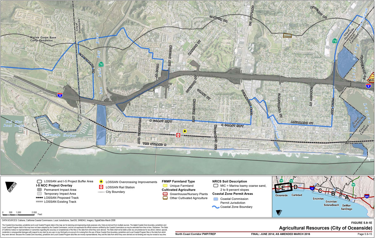
City of Oceanside
No agricultural parcels located within I-5 or LOSSAN area of potential effect.
Prime agricultural land standards per Coastal Act Section 30241
- Class I or Class II Soils, as defined by the Natural Resource Conservation Service. Soils with less than Class II would not be considered prime.
- Land with a Storie Index Rating of 80 through 100; Storie Index Rating = [(Factor A/100) X (Factor B/100) X (Factor C/100) X Factor D/100) X 100], where Factor A = Soil Profile Group; Factor B = Surface Texture; Factor C = Slope; Factor D = Drainage, Alkalinity, Fertility, Acidity, Erosion and Microrelief. Land with a Storie Index Rating below 80 would not be considered prime. Source: Soil Survey of San Diego Area, CA, USDA Soil Conservation Service (December 1973).
- Land with the ability to support livestock used for the production of food and fiber with an annual carrying capacity equivalent to at least one animal unit per acre as defined by the United States Department of Agriculture is considered prime agricultural land pursuant to Coastal Act Section 30241. "Animal unit month" is defined by the USDA as the amount of forage or feed required to feed one animal unit (one cow, one horse, one mule, five sheep, or five goats) for 30 days; roughly 12,000 pounds of forage per year is required to satisfy this element of the prime agricultural land definition. Minimum parcel size 100 acres for grazing to sustain 1 cow/calf unit.
- Land planted with fruit- or nut-bearing trees, vines, bushes, or crops which have a nonbearing period of less than five years and which will normally return during the commercial bearing period on an annual basis from the production of unprocessed agricultural plant production not less than $200 per acre.
- Even if land does not meet the prime agricultural land definition per Coastal Act Section 30241, Section 30242 of the Coastal Act applies to all agricultural lands on the urban-rural boundary and imposes limits on both agricultural development and conversions of agricultural uses to nonagricultural uses, regardless if the agricultural lands are prime, or lands suitable for agriculture.

There are no designated agricultural lands in Del Mar and Solana Beach; however, Solana Beach has a very small amount of greenhouse and nursery agriculture (Figure 5.9-1B). None of these parcels meet the Coastal Act standards for prime agricultural land, although they are lands suitable for agricultural use and therefore subject to the protections in Coastal Act Section 30242. Though both of these cities once contributed to the agricultural production of the region, rapid growth has led to the subsequent development of these agricultural lands primarily for urban uses.
Encinitas
As compared to the other cities in the corridor, a relatively large amount of land within Encinitas is devoted to some form of agricultural use, some of which lie adjacent to the I-5 highway corridor. These lands include Prime Farmland, Farmland of Statewide Importance, Unique Farmland, and lands subject to Williamson Act contract and agriculture preserve (Figure 5.9-1B and Figure 5.9-1C). The majority of agricultural uses within the city are in the form of nurseries or greenhouses, which are unaffected by the adjacent nonagricultural uses.
A parcel of active agricultural land designated as Prime Farmland, which is often cultivated with strawberries and flowers, is located east of I-5 at Manchester Avenue. Anderson"s La Costa Nursery and West Coast Nurseries are designated as Unique Farmland, although the properties are designated for residential use,3 and are located south of Batiquitos Lagoon approximately 220 feet west of I-5 and north of La Costa Avenue. Weidner's Gardens and Samia Rose Topiary are also designated Unique Farmland and are located adjacent to and east of I-5 and north of Leucadia Boulevard. The Leucadia Nursery and Emerald M. Growers, both of which are designated as Unique Farmland, are located north of and adjacent to Leucadia Boulevard and east of I-5. Two Unique Farmland properties that house greenhouse and nursery operations (Florabunda and Pacific Verde Nursery) are located east of and adjacent to I-5 at Union Street. Paul Ecke Ranch, the world"s largest poinsettia producer, consists of Unique, Prime, and Farmland of Statewide Importance, as well as lands under the Williamson Act contract, and is located 0.25 mile east of I-5 south of Puebla Street. Sunshine Gardens, a nursery and greenhouse operation designated as Unique Farmland, is located 0.25 mile east of I-5 at Encinitas Boulevard. Three greenhouse operations located near the proposed project are not designated as Important Farmland. These include the Cal Pacific Orchid Farm west of I-5 on Orpheus Avenue, the Jungle Music Nursery located immediately west of I-5 on Ocean View Avenue, and a greenhouse located north of Puebla Street. Although many of these parcels are in active agricultural and/or greenhouse operations, most do not have underlying NRCS soil classifications; of the seven total parcels that do have associated soil and/or Storie Index ratings, none meet the Coastal Act standards for prime agricultural land, although they are lands suitable for agricultural use and therefore subject to the protections in Coastal Act Section 30242.
Carlsbad
A sizeable quantity of agricultural land also occurs within Carlsbad (Figure 5.9-1D). Two greenhouse and agricultural operations designated as Unique Farmland are located in north Carlsbad. A greenhouse and agricultural operation is located south of Buena Vista Lagoon, east of I-5 and south of Jefferson Street. The Miles Pacific Nursery, the second greenhouse and agricultural operation, is located approximately 0.4 miles east of I-5, north of Carlsbad Village Drive.
Larger parcels of agricultural land in Carlsbad are located south of Agua Hedionda Lagoon. The Flower Fields (approximately 50 acres) is located 0.25 mile east of I-5 between Legoland and the Carlsbad Company Stores, and consists of the only property subject to Williamson Act contract in the city and is designated as Prime and Unique Farmland. A contiguous section of agricultural land is located south of Agua Hedionda Lagoon and bounded by I-5 to the west, Cannon Road to the south, and open space to the east. This portion of land is designated as Prime Farmland and Farmland of Statewide Importance and is used primarily for strawberries but also supports flower production. A parcel of Farmland of Local Importance, which houses greenhouses and some agricultural uses, is located adjacent to and west of I-5 along Avenida Encinas. However, none of these parcels meet the Coastal Act standards for prime agricultural land, although they are lands suitable for agricultural use and therefore subject to the protections in Coastal Act Section 30242.
Oceanside
There are no designated agricultural lands in the study area within Oceanside; however, inland of the NCC, the entire northeast portion of the city is designated for agricultural uses (Figure 5.9-1E). The agriculture industry in Oceanside is valued at approximately $12 million annually, which accounts for approximately 10% of San Diego County"s agricultural output. Major crops within Oceanside, as well as the region, include tomatoes, avocados, citrus, and nursery stock.
5.9.2 PWP/TREP Concerns
Environmental documentation and analysis prepared for the proposed LOSSAN rail and I-5 highway corridor improvements confirm that a number of agricultural lands supporting a variety of agricultural resources occur in the corridor and in areas potentially affected by the proposed improvements. Potential impacts of the proposed rail and highway improvements to agricultural resources could occur from the direct displacement of agricultural lands or operations because of expanded or modified facility footprints or temporary displacement caused by construction/assembly and construction staging areas that may be proposed within an area used for agricultural production.
5.9.2.1 LOSSAN Rail Corridor Impact Assessment
Proposed rail improvements would occur adjacent to areas designated as Unique Farmland and Farmland of Local Importance in Encinitas and Carlsbad, respectively; however, in these areas, proposed rail improvements would occur within the existing rail corridor right-of-way and, therefore, impacts to the adjacent agricultural lands are not anticipated. Furthermore, none of these parcels meet the Coastal Act standards for prime agricultural land. However, temporary impacts to agricultural resources could result from the temporary conversion of important agricultural lands or other temporary disruption of agricultural activities during construction because of construction/assembly and construction staging areas that may be proposed within an area used for agricultural production.
5.9.2.2 I-5 Highway Corridor Impact Assessment
Impacts on agricultural lands from proposed highway improvements would occur only in the cities of Encinitas and Carlsbad. The proposed highway improvements would affect approximately 10.9 total acres of Prime Farmland, non-Prime Farmland identified as Unique Farmland, and lands in agricultural production but not designated as Important Farmland. None of these parcels meet the Section 30241 Coastal Act standards for prime agricultural land as identified in Table 5.9-1, but most are in active agricultural production and therefore subject to the protections in Coastal Act Section 30242. The proposed highway improvements within San Diego, Del Mar, Solana Beach, and Oceanside would not result in encroachment or edge impacts along the existing I-5 highway corridor to designated or active agricultural lands. Therefore, the highway improvements would not adversely affect the productivity of nor preclude continued agricultural activities of agricultural lands in these cities.

Encinitas
The proposed highway improvements within Encinitas would include a new transit facility, park-and-ride, and direct access ramp (DAR) at Manchester Avenue, which would affect active agricultural fields east of and adjacent to I-5. The proposed transit facilities would encroach into a 30.5-acre property designated as Prime Farmland that is actively farmed and often cultivated with strawberries and flowers. The proposed highway facilities would affect approximately 6.9 acres of the western portion of the Prime Farmland adjacent to I-5. To avoid and minimize potential impacts to agricultural land, the Locally Preferred Alternative for I-5 includes the smallest project footprint for the highway improvements, the footprint of the new multi-use facility at Manchester Avenue was redesigned to accommodate only about 150 parking spaces, and the DAR redesigned as an under-crossing, thereby reducing total impacts from the previously identified 18.5 acres to 6.9 acres. The remaining 23.6 acres, which are located on a more eastern slope of the parcel, could continue in agricultural production. Coordination between the San Diego Association of Governments (SANDAG), the California Department of Transportation (Caltrans), and the landowner are underway to determine the possibility of continuing agricultural operations or purchasing the property (or partial purchase) for habitat restoration purposes.
Proposed highway improvements would also affect approximately 0.2 acres along the western edge of Unique Farmland properties that house greenhouse and nursery operations (e.g., Pacific Verde Nursery), which are located east of, and adjacent to, I-5 at Union Street; however, the project encroachments would affect only the edge of the facilities and would not preclude agricultural activities in the greenhouse or nursery on the remainder of the parcel.
No other designated or active farmlands would be affected by the proposed project.
Carlsbad
The proposed highway improvements at Cannon Road would encroach into a 106.2-acre property that is actively farmed and often cultivated with strawberries and flowers. Proposed highway improvements would directly affect approximately 2.3 acres of these agricultural lands within Carlsbad, which are designated as Prime Farmland and Farmland of Statewide Importance, and are located south of Agua Hedionda Lagoon and bounded by I-5 to the west, Cannon Road to the south, and open space to the east; however, the impact would be linear along the western edge of the property and would not bisect or preclude continued agricultural operation of the remaining 103.9 acres. To avoid and minimize potential impacts to agricultural land, the Locally Preferred Alternative for I-5 includes the smallest project footprint for the highway improvements and eliminates the DAR previously proposed at Cannon Road, thereby reducing impacts to agricultural land within Carlsbad from the previously identified 16 acres to 2.3 acres. No other agricultural land or operations in Carlsbad would be affected by the project.
Temporary Construction Impacts
Temporary, construction-related impacts to agricultural resources throughout the corridor could result from the conversion of important agricultural lands or other disruption of agricultural activities because of construction/assembly and construction staging areas that may be proposed within an area used for agricultural production.
Resource Enhancement and Mitigation Program Opportunities
Caltrans is pursuing opportunities to acquire properties in the corridor for purposes of implementing the Resource Enhancement and Mitigation Program (REMP; discussed in Chapter 6B) to help restore, enhance, and expand coastal wetlands, freshwater wetlands, and upland areas. As part of the PWP/TREP, the mitigation sites would be acquired and restored or preserved for purposes of habitat enhancement or preservation to offset potential resource impacts of the proposed I-5 highway and LOSSAN rail improvements and, where feasible, to improve already degraded resources. Potential mitigation sites could include properties designated (currently or previously used) for agricultural purposes, which could adversely impact agricultural resources.
5.9.3 PWP/TREP Opportunities, Design/Development Strategies, and Policies/Implementation Measures
5.9.3.1 Corridor Opportunities
Enhanced Pedestrian Overpass Connection on Bush Street. The PWP/TREP includes a community enhancement project in Oceanside that would connect the existing community gardens at Civic Center Drive and Witzel Street across an enhanced overpass and follow the freeway in a linear park to Mission Avenue. This project would extend existing, thriving community gardens and would join the communities separated by I-5 with a new sidewalk and widening of existing sidewalks, a paved trail from the east side of the bridge along the on-ramp to Buena Street, and new and improved lighting and landscaping.
5.9.3.2 PWP/TREP Policies
Caltrans and SANDAG would implement the following policy to ensure that proposed improvements are designed, implemented, and maintained to provide for maximum protection of agricultural resources as identified on Figures 5.9-1A-E:
Policy 5.9.1
New multimodal transportation development and associated community enhancement and habitat restoration improvements shall avoid and minimize impacts to agricultural resources consistent with Sections 30241 and 30242 of the Coastal Act. Where new development may potentially convert agricultural uses to non-agricultural uses, appropriate mitigation measures shall be required and implemented.
5.9.3.3 PWP/TREP Design/Development Strategies
The following design and development strategies provide guidance for siting and designing specific PWP/TREP rail projects, and Caltrans/SANDAG shall utilize the following design and development strategies for all projects subject to Notice of Impending Development (NOID) procedures, consistent with the coastal agricultural resource protection policies of PWP/TREP Policy 5.9.1, amended local coastal programs (LCPs) and the Coastal Act:
- For projects that result in potential impacts to Prime coastal agricultural resources or active coastal agricultural lands (determined by the Coastal Commission pursuant to project-specific environmental review and NOID, federal-consistency, or coastal development permit review, as applicable), appropriate site-specific mitigation measures would be implemented. Mitigation measures would preserve and enhance coastal agricultural resources within the NCC Coastal Zone and could include developing and implementing a program or projects that encourage "urban agriculture." Types of urban agriculture could include farm-to-fork restaurants; buy local; farm-to-grocery store; vertical farming; farmers" markets; innovative approaches to "urban agriculture" that help to create a demonstration project; or re-tooling existing agricultural operations to allow for vertical farming, innovative approaches to farming, or substantial reduction in water usage.
5.9.3.4 Implementation Measures
Caltrans/SANDAG shall utilize the following implementation measures for all projects subject to NOID procedures:
- Implementation Measure 5.9.1: Permanent impacts to active coastal agricultural land, or land suitable for agriculture, shall be mitigated on a site-specific basis, utilizing a tiered approach. The first tier for implementation includes project-specific mitigation to be located within the affected jurisdiction and could include specific activities such as acquiring, enhancing, or restoring other nonagricultural lands for agricultural use within the Coastal Zone or by the preservation of existing agricultural lands by retiring these lands from future development potential. For opportunities that result in the conversion of nonagricultural lands to agricultural uses, any required remediation activities would be completed in compliance with county, federal, and other applicable standards for hazardous materials. As part of this first tier of projects, public outreach would be implemented to engage the surrounding neighborhood(s) throughout the implementation process.
The second tier for implementation would be for establishing school or community gardens within the affected jurisdiction within the Coastal Zone.
Should a specific mitigation project within the affected jurisdiction not be feasible (tier 1), or a higher priority opportunity within the Coastal Zone not be available (tier 2), the third tier shall be implemented, which includes payment of an Agricultural Conversion Mitigation Fee, pursuant to an approved in-lieu fee program covering coastal agricultural resources. The fee would be based on net acreage of affected coastal agricultural lands and reflect the approximate cost of preserving equivalent coastal agricultural lands elsewhere in the NCC Coastal Zone. If the City of Carlsbad"s existing Agricultural Conversion Mitigation Fee program is able to be utilized, fund money would be dispersed according to the program"s own priorities. Mitigation fees would be handled by Caltrans/SANDAG and/or the affected jurisdiction if within a currently approved in-lieu fee program, and would be expended in the following order of priority:- Purchase of agricultural lands and/or agricultural improvements that will aid in continuous agricultural production within the NCC Coastal Zone.
- Committing to specific activities that support "urban agriculture," such as farm-to-school programs, farm-to-fork restaurants, buy local, farm-to-grocery stores, vertical farming, farmers" markets, innovative approaches to "urban agriculture" that help to create a demonstration project, re-tooling existing agricultural operations to allow for vertical farming, innovative approaches to farming, or substantial reduction in water usage, or endowments to programs of study in agricultural sciences in the NCC Coastal Zone.
- If determined feasible and desirable by the County of San Diego, coordinating with the county to establish a fund to offset loss of Williamson Act subvention funds from the state for 2009/2010, which would be used to assist the county in supporting agricultural resources and offsetting the lack of state subvention funds in 2009/2010 for the Williamson Act.
- Implementation Measure 5.9.2: Construction staging and phasing plans shall be prepared and submitted with each NOID for all transportation improvement and associated community enhancement projects included in the PWP/TREP and shall include information that specifies and quantifies any agricultural resource areas that may be impacted by temporary project construction activities. Temporary impacts to agricultural resources due to construction/assembly and construction staging areas, including temporary conversion of agricultural lands or other temporary disruption of agricultural activities, shall be fully mitigated by returning any affected area to pre-existing agricultural use after project construction is completed. Temporary impacts to agricultural resources due to construction/assembly and construction staging areas shall not cause a long-term reduction in productivity or conversion of the subject lands to nonagricultural use, which would result in a significant economic loss to the county"s agricultural economy. Analysis of temporary impacts from construction activities shall be conducted for each NOID submittal in order to determine any loss of income or agricultural production incurred as a result of the proposed construction activities, and appropriate mitigation/compensation shall be applied in the event that impacts are identified.
- Implementation Measure 5.9.3: Plans for habitat restoration on properties supporting existing agricultural uses shall be prepared and submitted with the applicable NOID for restoration activities, and shall include information that specifies and quantifies any important agricultural resource areas that may be impacted by restoration activities. If determined by the Coastal Commission that restoration activities would adversely affect prime agricultural land, as defined by and in accordance with Coastal Act standards for prime agricultural land, or land suitable for agriculture, such impacts shall be fully mitigated pursuant to Implementation Measure 5.9.1.
- Implementation Measure 5.9.4: An economic feasibility study shall be conducted for any proposed specific project that would result in permanent impacts to agricultural resources in order to determine whether or not continued agricultural production would be possible after the project-related impacts have occurred.
5.9.4 Coastal Act Consistency
Coastal Act Section 30241
The maximum amount of prime agricultural land shall be maintained in agricultural production to assure the protection of the area"s agricultural economy, and conflicts shall be minimized between agricultural and urban land uses through all of the following:
- (a) By establishing stable boundaries separating urban and rural areas including, where necessary, clearly defined buffer areas to minimize conflicts between agricultural and urban uses.
- (b) By limiting conversions of agricultural lands around the periphery of urban areas to the lands where the viability of existing agricultural use is already severely limited by conflicts with urban uses or where the conversion of lands would complete a logical and viable neighborhood and contribute to the establishment of a stable limit to urban development.
- (c) By permitting the conversion of agricultural land surrounded by urban uses where the conversion of the land would be consistent with Section 30250.
- (d) By developing available lands not suited for agriculture prior to the conversion of agricultural lands.
- (e) By assuring that public service and facility expansions and nonagricultural development do not impair agricultural viability, either through increased assessment costs or degraded air and water quality.
- (f) Assuring that all divisions of prime agricultural lands, except those conversions pursuant to subdivision (b) of this section, and all development adjacent to the prime agricultural lands shall not diminish the productivity of such prime agricultural lands.
Coastal Act Section 30241.5
- (a) If the viability of existing agricultural uses is an issue pursuant to subdivision (b) of Section 30241 as to any local coastal program or amendment to any certified local coastal program submitted for review and approval under this division, the determination of "viability" shall include, but not be limited to, consideration of an economic feasibility evaluation containing at least both of the following elements:
- An analysis of the gross revenue from the agricultural products grown in the area for the five years immediately preceding the date of the filing of a proposed local coastal program or an amendment to any local coastal program.
- An analysis of the operational expenses, excluding the cost of land, associated with the production of the agricultural products grown in the area for the five years immediately preceding the date of the filing of a proposed local coastal program or an amendment to any local coastal program.
- For purposes of this subdivision, "area" means a geographic area of sufficient size to provide an accurate evaluation of the economic feasibility of agricultural uses for those lands included in the local coastal program or in the proposed amendment to a certified local coastal program.
- (b) The economic feasibility evaluation required by subdivision (a) shall be submitted to the commission, by the local government, as part of its submittal of a local coastal program or an amendment to any local coastal program. If the local government determines that it does not have the staff with the necessary expertise to conduct the economic feasibility evaluation, the evaluation may be conducted under an agreement with the local government by a consultant selected jointly by local government and the executive director of the commission.
Coastal Act Section 30242
All other lands suitable for agricultural use shall not be converted to nonagricultural uses unless:
- continued or renewed agricultural use is not feasible, or
- such conversion would preserve prime agricultural land or concentrate development consistent with Section 30250. Any such permitted conversion shall be compatible with continued agricultural use on surrounding lands.
Coastal Act Section 30250
- (a) New residential, commercial, or industrial development, except as otherwise provided in this division, shall be located within, contiguous with, or in close proximity to, existing developed areas able to accommodate it or, where such areas are not able to accommodate it, in other areas with adequate public services and where it will not have significant adverse effects, either individually or cumulatively, on coastal resources. In addition, land divisions, other than leases for agricultural uses, outside existing developed areas shall be permitted only where 50 percent of the usable parcels in the area have been developed and the created parcels would be no smaller than the average size of surrounding parcels.
- (b) Where feasible, new hazardous industrial development shall be located away from existing developed areas.
- (c) Visitor-serving facilities that cannot feasibly be located in existing developed areas shall be located in existing isolated developments or at selected points of attraction for visitors.
Sections 30241 of the Coastal Act requires that the maximum amount of prime agricultural land be maintained in agricultural production and that conflicts between urban and agricultural land uses be minimized through means such as but not limited to establishing stable urban-rural boundaries, limiting conversion of agricultural lands around the periphery of urban areas to those lands where the viability of existing agricultural use is already severely limited, permitting the conversion of agricultural land surrounded by urban uses where the conversion of the land would be consistent with Section 30250, assuring that public service and facility expansions do not impair agricultural viability, either through increased assessment costs or degraded air and water quality and assuring that development adjacent to prime agricultural lands does not diminish the productivity of those lands. In addition, Section 30242 of the Coastal Act protects non-prime agricultural lands from conversion to nonagricultural use unless continued agricultural use is not feasible, or the conversion would preserve prime agricultural land or concentrate development consistent with Section 30250. Any permitted conversion of agricultural land is required to be compatible with continued agricultural use on surrounding lands.
5.9.4.1 PWP/TREP Agricultural Resource Impacts
Proposed transportation improvements would result in impacts to agricultural resources as described above. As the existing location of the NCC rail and highway facilities requires that some PWP/TREP improvements occur in areas directly adjacent to or within agricultural lands and/or operations, it is infeasible to avoid all impacts to agricultural resources during construction of the proposed improvements. However, although none of the identified agricultural parcels meet the Coastal Act standards for prime agricultural land as identified in Table 5.9-1, Coastal Act Section 30242 protects all other lands suitable for agriculture and prohibits their conversion to nonagricultural uses unless agricultural use is not feasible or conversion would preserve prime agricultural land or concentrate development in existing developed areas.
As discussed in Section 5.2, most of the NCC is considered nearly fully developed with urban uses, with only 5% of the land area remaining potentially developable within the six NCC cities. Within Carlsbad and Encinitas, where the NCC PWP/TREP projects would result in impacts to agricultural lands protected pursuant to Coastal Act Section 30242, remaining developable land consists of only 6% and 7% of the cities" total land area, respectively. As such, all of the PWP/TREP improvements would be located within an urban corridor and would be immediately adjacent to and contiguous with the existing transportation facilities in close proximity to existing developed areas. As discussed in Section 5.2, these improvements would serve to concentrate on future development within the urban corridor by supporting Smart Growth. However, the proposed PWP/TREP improvements would nonetheless convert portions of lands used for agriculture and would result in impacts potentially inconsistent with Section 30242 of the Coastal Act.
As detailed in Section 5.10, although the proposed PWP/TREP is potentially inconsistent with Section 30242 of the Coastal Act, the PWP/TREP can be found consistent with the Coastal Act through the conflict resolution provision of Coastal Act Section 30007.5 by demonstrating, among other things, that no other feasible, less-damaging alternative exists for project components that would result in unavoidable impacts to agricultural resources. Furthermore, feasible mitigation measures must be identified in the PWP/TREP to minimize substantial adverse impacts on agricultural resources.
Evaluation of Feasible Alternatives
Section 5.10, Coastal Act Policy Conflict Resolution, includes an analysis of project alternatives proposed to address mobility deficiencies and enhance multimodal access throughout the corridor, including design-level considerations for those facilities resulting in linear agricultural resource impacts. Based on this analysis, the program of rail and highway improvements included in the PWP/TREP provides the least environmentally damaging, feasible project alternative to avoid or reduce impacts to coastal resources. The proposed PWP/TREP improvements would consist primarily of improvements to existing transportation facilities located in previously developed and disturbed areas within existing rail and highway right-of-way. Improvements or changes to transportation facilities would generally be expansions or reconfigurations of existing facilities. Therefore, by design, the proposed PWP/TREP improvements would involve limited expansion or encroachment into adjacent agricultural resource areas while accommodating existing and future travel demand within the NCC"s existing LOSSAN and I-5 transportation corridors. By accommodating existing and future travel demand within the NCC"s existing, primary transportation corridors, the PWP/TREP would serve to limit potential impacts to agricultural uses that might otherwise occur if new transportation infrastructure were to be constructed as separate and distinct facilities from the existing rail or highway right-of-way, or other arterial roads expanded outside of the main transportation corridors, to address mobility deficiencies and enhanced multimodal access throughout the corridor.
Proposed rail improvements would occur adjacent to areas designated as Unique Farmland and Farmland of Local Importance in Encinitas and Carlsbad, respectively; however, in these areas, proposed rail improvements would occur within the existing rail corridor right-of-way and therefore impacts to the agricultural lands are not anticipated. In addition, rail facilities are typically considered compatible land uses with agricultural areas given that there are relatively few sensitive receptors associated with agricultural uses that could be exposed to facility noise and vibration. While the existing and proposed transportation facilities constitute developed land uses, the transportation facilities do not in and of themselves consist of land uses that define or otherwise influence adjacent land uses, and therefore the proposed improvements would not create a conflict between agricultural and transportation land uses. Therefore, the LOSSAN rail corridor improvements would have no impact on Prime Farmland or any permanent impact on other agricultural land or resources. Though impacts to agricultural resources are not anticipated for rail improvements, feasible project alternatives for rail improvements potentially affecting agricultural resources would be determined in project-level analyses and during phased federal consistency review, as applicable.
The project alternative analysis for highway improvements potentially affecting agricultural resources is part of the I-5 NCC Project Final EIR/EIS. Additional design-level alternatives analysis, including detailed avoidance and minimization considerations, has been completed and is reflected within the selection of the Locally Preferred Alternative, as described in detail within the I-5 NCC Project Final EIR/EIS. This design detail, including a reduced project footprint throughout the corridor and for the Manchester Avenue DAR, redesign of the San Elijo Multi-Use Facility, removal of the Cannon Road DAR, and other corridor-wide auxiliary lane reconfigurations and/or removals, reduces overall project impacts to agricultural lands from 34.5 acres previously identified to 9.4 acres. Proposed highway improvements have been designed to avoid all previously identified impacts to agricultural lands in the City of San Diego, to reduce potential project impacts from 18.5 to 7.1 acres in Encinitas, and to reduce potential project impacts from 16 to 2.3 acres in Carlsbad.
Temporary impacts to agricultural resources could also result from the conversion of important agricultural lands or other disruption of agricultural activities during construction due to construction/assembly and construction staging areas that may be proposed within an area used for agricultural production.
Feasible Mitigation Measures
Section 5.9.3, described previously, and the following consistency analyses for proposed rail and highway improvements demonstrate that mitigation measures are required by the PWP/TREP as project design features and/or policies and implementation measures to minimize all potential impacts to agricultural resources. Where new development could adversely affect agricultural resources, appropriate mitigation measures shall be required and implemented. This provision would ensure project consistency with applicable agricultural resource protection policies should previously unidentified permanent or temporary project impacts to agricultural resources be determined during any future project-specific review processes.
Potential transportation improvement impacts to agricultural resources would be avoided to the maximum extent feasible through project design, which would ensure the amount of right-of-way required for improvements would be the minimum amount of land required to fulfill the purpose and need of the project, as well as meet operational requirements of the facilities. Wherever possible, the proposed project would follow within the existing rail and I-5 highway corridor alignments to avoid and/or minimize impacts to farmland and agricultural lands, which would result in avoidance or only minimal encroachment along the edges of agricultural lands located directly adjacent to the existing facilities. As such, the majority of proposed project encroachments onto lands containing agricultural resources would not substantially displace agricultural resources or disrupt or preclude continued agricultural operations of the properties.
According to the San Diego County Farm Bureau, the county has 312,766 acres of farmland. The Agricultural Commissioner"s Office reports that the total number of acres of agriculture in the San Diego County Coastal Zone is 955 acres. Proposed PWP/TREP highway improvements would directly, cumulatively affect approximately 10.9 acres of Prime Farmland, non-Prime Farmland identified as Unique Farmland, and other lands in agricultural production but not designated as Important Farmland. This represents about 1% of the total amount of agricultural land in the San Diego County Coastal Zone.
Although the proposed highway improvements would result in permanent impacts to 9.4 acres of farmland, given the linear nature of the improvements, the majority of impacts would be contained to only four total agricultural parcels located in areas directly adjacent to the existing highway, and therefore the majority of project impacts would not substantially displace agricultural resources or disrupt or preclude continued agricultural operations of the affected properties. The incremental encroachment impacts on agricultural lands from proposed highway improvements would not result in substantial impacts to agricultural resources where the majority of agricultural production in the corridor already occurs on small, isolated lands in a relatively urbanized area. In addition, while the proposed highway improvements would directly affect agricultural resources in the corridor, the impacts would be minor when compared to the total amount of agricultural resources in the San Diego County Coastal Zone.
The most significant impacts are to agricultural lands adjacent to the highway that would be affected at Manchester Avenue in Encinitas (approximately 6.9 acres) and at Cannon Road in Carlsbad (approximately 2.3 acres). Pursuant to the Agricultural Viability Analysis (Appendix F) conducted for the affected agricultural lands, potential impacts would not compromise the ability for the remaining 23.6 and 103.9 acres of land unaffected at the Manchester Avenue and Cannon Road locations, respectively, to remain in agricultural production. However, as discussed in more detail in Section 5.2 (Public Transit and Smart Growth), the proposed improvements and associated impacts would be necessary to concentrate and maintain anticipated development growth within and/or contiguous to the existing developed corridor. By maintaining and, where feasible, improving the existing public transportation system within the corridor, the new development would be concentrated and supported in an area of existing and adequate public services, which in turn would limit development sprawl into undeveloped areas. Any growth that would occur in the NCC would be supported by the proposed infrastructure improvements, would be infill or redevelopment, and would serve to replace growth that could otherwise occur at the urban fringe or beyond, resulting in development pressure on rural lands. Furthermore, with the implementation of the proposed PWP/TREP implementation measures, the project would create or preserve significant agricultural resources in other areas of the corridor and/or county. As such, the proposed PWP/TREP improvements, in conjunction with applicable agricultural implementation measures, would limit conversion of agricultural lands to isolated areas within the urban corridor (and to areas located directly adjacent to the highway and/or rail facilities) and would serve to accommodate anticipated development in the urban corridor and thus maintain a stable urban/rural boundary while creating or preserving significant agricultural resources within the county.
Implementation Measure 5.9.1 of the PWP/TREP provides that unavoidable impacts to active coastal agricultural lands within the cities of Encinitas and Carlsbad are to be mitigated pursuant to a tiered approach, with the highest priority being implementation of a project-specific mitigation such as acquiring, enhancing or restoring other lands for agricultural use or by the preservation of existing agricultural lands by retiring these lands from future development potential. The second tier would be for establishing a school or community garden within the affected jurisdiction. And the third tier (lowest priority) would be for payment of an in-lieu fee under an approved Agricultural Conversion Mitigation Fee program, such as that implemented within the City of Carlsbad.
The Agricultural Conversion Mitigation Fee program included in Carlsbad"s Local Coastal Program (LCP), certified by the Coastal Commission in 1996 (and amended in 2000, 2002, 2003, 2006, and 2010), applies only to agricultural impacts within the Mello II Land Use Segment but could be expanded to the Agua Hedionda Lagoon Land Use Segment, where PWP/TREP impacts would occur, as part of their ongoing LCP Amendment certification efforts with the Coastal Commission. For impacts within the City of Encinitas, should implementation of tier-one project-specific mitigation not be feasible, development of an Agricultural Conversion Mitigation Fee program modeled after the City of Carlsbad"s program would be conducted. The purpose and intent of an Agricultural Resource Impact Mitigation Fee program would be to contribute to additional efforts to support and maintain agricultural lands and practices within the NCC Coastal Zone, such as:
- Purchasing agricultural lands or improving agriculture in ways that would aid in continuous agricultural production within the NCC Coastal Zone.
- Committing to specific activities that support "urban agriculture," such as farm to school programs, farm-to-fork restaurants, buy local, farm-to-grocery stores, vertical farming, farmers markets, innovative approaches to "urban agriculture" that help to create a demonstration project, re-tooling existing agricultural operations to allow for vertical farming, innovative approaches to farming, or substantial reduction in water usage, and/or endowments to programs of study in agricultural sciences in the NCC Coastal Zone.
- If determined feasible and desirable by the County of San Diego, coordinating with the county to establish a fund that would be used to assist the county in supporting agricultural resources and offsetting the lack of state subvention funds in 2009/2010 for the Williamson Act.
The PWP/TREP would provide new opportunities to preserve and maintain a variety of agricultural resources and activities in the corridor by instigating proposed implementation measures and community enhancement features. The opportunities would range from supporting efforts to preserve large agricultural lands or operations to extending or providing new community gardens as is being proposed for the community enhancement project in Oceanside (Enhanced Pedestrian Overpass Connection on Bush Street). It should be noted that with the fiscal constraints on the state"s budget, the subvention funds provided to counties (and cities) through the state for parcels under the Williamson Act program were reduced to a one-time, pro-rata amount. With this in mind, the PWP/TREP Agricultural Resource Impact Mitigation Fee could provide an opportunity to establish a fund to offset the loss of Williamson Act subvention funds from the state.
Temporary impacts on agricultural resources could result from temporary conversion of agricultural lands or other temporary disruption of agricultural activities during construction because of construction/assembly and construction staging areas that may be proposed within an area used for agricultural production. Pursuant to Implementation Measure 5.9.2 of the PWP/TREP, however, any temporarily affected agricultural areas or operations would be fully returned to pre-existing agricultural use after project construction is completed–without long-term reduction in productivity or conversion of the subject lands to nonagricultural use that could result in a significant economic loss to the county"s agricultural economy. The potential loss of income or agricultural production from temporary construction-related impacts would require appropriate mitigation.
In addition, Caltrans has acquired properties in the corridor for implementing the REMP to restore, enhance, and expand coastal wetlands, freshwater wetlands, and upland areas in the NCC. As part of the PWP/TREP, the mitigation sites would be restored or preserved for habitat enhancement or preservation to offset potential resource impacts of the proposed LOSSAN rail and I-5 highway improvements and, where feasible, to improve already degraded resources. Potential mitigation sites could include properties designated (currently or previously used) for agricultural purposes, which could affect agricultural resources. Implementation Measure 5.9.3 of the PWP/TREP requires that plans for habitat restoration on properties supporting existing agricultural uses be prepared and submitted with the applicable NOID for restoration activities, and that the plans would include information that specifies and quantifies any lands suitable for agriculture that could be adversely affected by restoration activities. Should it be determined by the Coastal Commission that proposed restoration activities would adversely affect lands suitable for agriculture, Implementation Measure 5.9.3 requires that impacts to agricultural land be fully mitigated pursuant to Implementation Measure 5.9.1 of the PWP/TREP.
Based on available project and environmental data and the policies and implementation measures included herein, the proposed improvements would be implemented such that the maximum amount of agricultural land in the corridor would be maintained in agricultural production and conflicts between urban and agricultural land uses would be minimized. While the existing and proposed transportation facilities constitute developed land uses, the transportation facilities do not in and of themselves consist of land uses that define or otherwise influence adjacent land uses, and therefore the proposed improvements would not create a conflict between agricultural and transportation land uses. In addition, where facility improvements could adversely affect agricultural resources, policies and implementation measures would be applied (as identified in this section) to ensure the impacts would be avoided or minimized, and that impacts would be adequately mitigated such that the improvements would not result in substantial impacts to agricultural resources.
5.9.4.2 Coastal Act Consistency Analysis Summary
While proposed LOSSAN rail improvements could affect adjacent agricultural resources in the corridor, the majority of program improvements would occur within the existing facility rights-of-way. In this regard, proposed rail improvements would avoid, to a large extent, potential impacts to agricultural resources through design.
Where proposed I-5 highway improvements would result in unavoidable impacts to adjacent agricultural resources, the long-term viability of the affected agricultural resources and operation would not be affected. All permanent impacts to agriculture would be mitigated pursuant to the proposed tiered agricultural mitigation program within the coastal zone.
Furthermore, proposed improvements that would directly affect agricultural resources are necessary to maintain a critical coastal access corridor and public service while concentrating and maintaining anticipated development within and/or contiguous with the existing developed facility. In addition to maintaining the primary coastal access corridors in the NCC, the proposed improvements are critical to goods movement, which has a direct effect on the viability of agricultural operations in the region and the state. The majority of agricultural commodities in California are transported from farms to markets via ground transportation; thus, the ability to transport local agricultural commodities to large markets through vital arteries such as the I-5 is also critical to the preservation and continued viability of agricultural operations in the NCC, throughout the region, and beyond. Moreover, the close proximity of transportation corridors to agricultural areas reduces costs associated with transporting commodities, and the reliability of these arteries is necessary to ensure delivery and equitable distribution of commodities and commensurate compensation to producers.
5.9.5 Local Coastal Program Consistency
5.9.5.1 Local Coastal Program Consistency Analysis Summary
Certified LCPs for Encinitas and Carlsbad include policies that mirror, in part, the requirements of Sections 30241 and 30242 of the Coastal Act that speak to preserving Prime Farmland and agricultural production. Where PWP/TREP improvements would affect agricultural resources, the corridor LCPs include a variety of policies to implement the requirements of Sections 30241 and 30242 of the Coastal Act. Because there is no potential for impacts to agricultural lands located within the cities of San Diego, Del Mar, Solana Beach, or Oceanside, no LCP policy conflicts would occur. The following summary discussion thus focuses on the certified policies of the cities of Encinitas and Carlsbad LCPs.
City of Encinitas
The City of Encinitas LCP designates a Special Study Overlay for Agricultural Land and includes the following policies to protect agricultural resources within the city and its sphere of influence:
- Preserve and promote the right to produce unique horticultural crops and community gardens.
- Encourage preserving "prime" agriculture lands within its sphere of influence.
- The Ecke Holdings, et al., is within the City of Encinitas" Coastal Zone sphere of influence… The City recognizes this land as "prime" agriculture suitability and as such, designates it for long-term preservation as "Agriculture/Open Space Preserve."
- Plan for compatible land uses within and adjacent to recreation areas, natural preserves, and agricultural areas.
The proposed highway improvements within Encinitas would, for the most part, result in only minimal encroachment and edge impacts along the existing I-5 highway corridor to three agricultural properties for a total of 7.1 acres. These impacts would be restricted to the edge of the agricultural lands and would not adversely affect the productivity of the sites nor would the proposed improvements preclude continued agricultural activities on the sites; however, proposed highway improvements would result in the loss of approximately 6.9 acres of agricultural land at Manchester Avenue, which according to the Agricultural Viability Analysis conducted for the subject parcel(s), would not affect the ability for continued agricultural use of the property. Although the three parcels potentially affected by the highway improvements do not meet the Coastal Act"s standards for prime agricultural land, because the City's LCP speaks to preserving and promoting the right to produce unique horticultural crops, a potential policy conflict occurs, requiring amendment to ensure consistency of the PWP/TREP improvements with the certified LCP.
As such, SANDAG and Caltrans will seek amendments to the City of Encinitas LCP, for which the standard of review would be Section 30242 of the Coastal Act. Should the PWP/TREP be found inconsistent with Section 30242 of the Coastal Act, the LCP amendment process may further allow the PWP/TREP to be analyzed for conflict resolution under Section 30007.5 of the Coastal Act. Section 5.10 evaluates the PWP/TREP improvements under the Coastal Act"s conflict resolution provision (Section 30007.5). The conflict resolution analysis concludes that denying or modifying the PWP/TREP to avoid the impacts to agricultural resources discussed in this section would conflict with several other Chapter 3 policies of the Coastal Act and, approving the PWP/TREP is, on balance, the most protective of significant coastal resources. Thus, the Coastal Commission could potentially rely on the conflict resolution provisions of the Coastal Act when considering an LCP Amendment that would allow this development in Encinitas.
City of Carlsbad
The City of Carlsbad LCP includes an extensive set of policies that address preserving and converting agricultural lands and mitigating the conversion of such lands when permitted pursuant to the LCP. As discussed in the Coastal Act consistency analysis above, the majority of agricultural resource impacts from the proposed improvement would be linear in nature and would result in minor, incremental encroachment into adjacent agricultural lands that would not adversely affect the agricultural productivity or operations of those lands. Proposed highway improvements would only affect approximately 2.3 acres of Prime and Unique Farmland at Cannon Road. The location of this impact would occur in the Agua Hedionda Lagoon planning area of the city, which is the only uncertified segment of the City's certified LCP. As such, the Coastal Commission retains permit jurisdiction in this area with the standard of review for the proposed improvements being the Chapter 3 policies of the Coastal Act; however, the policies contained within the certified Land Use Plan component of the Agua Hedionda Lagoon segment can be used as guidance. The Agua Hedionda Land Use Plan includes agricultural policies that state the conversion of any agricultural property must be consistent with the policies of the Coastal Act, as well as site-specific policies for south shore agricultural lands. The PWP/TREP proposes implementation of either a project-specific agricultural mitigation project, such as acquiring, enhancing, or restoring other lands for agricultural use and/or establishing a school or community garden or payment of an in-lieu fee to the City's certified Agricultural Conversion Mitigation Fee program to offset any impacts to coastal agricultural resources. Although the City's LCP does not extend to the Agua Hedionda Lagoon planning area, the City is looking into processing an LCP Amendment to allow for such, which would be applicable to offsetting PWP/TREP impacts. A previous LCP Amendment application, known as the Cannon Road Agricultural/Open Space Zone Amendment, was originally submitted to the Coastal Commission for review in August 2011 but has since been withdrawn. The City anticipates resubmitting this amendment to the Coastal Commission, but the timing of the resubmittal has not yet been determined. Until such time that the City's LCP Amendment is certified, the Chapter 3 policies of the Coastal Act will remain the standard of review for this portion of the City's Coastal Zone; therefore, the PWP/TREP improvements do not result in a policy conflict with the City's certified LCP.
Notes:
- San Diego Agriculture: Not Your Average Farm, County of San Diego. http://www.sdcounty.ca.gov/reusable_components/images/awm/Docs/stats_sdagriculture.pdf.
- San Diego County Crop Statistics and Annual Report, 2008.
- City of Encinitas, 1989.