
Section 5.4 – Marine Resources: Water Quality and Wetlands
This section examines how the PWP/TREP program of improvements would address potential project impacts to water quality and coastal wetlands, and how the PWP/TREP provides a unique opportunity to improve water quality along the transportation corridors and to enhance significant wetland resources in the North Coast Corridor (NCC). Taken together, the PWP/TREP improvements would:
- Implement a comprehensive, corridor-wide program to restore water quality and wetland habitat along the 30-mile NCC coastline.
- Maximize the treatment of surface water runoff through existing surfaces, and new impermeable surfaces, incorporating stormwater Best Management Practices (BMPs) within the project footprint and reducing the pollutant burden in stormwater runoff along I-5.
- 2031-2040 Phase Propose bridge/culvert replacement and bridge lengthening projects over specific lagoons and other coastal water bodies to better convey floodwaters and allow for improved tidal flushing, to reduce sedimentation and improve the flow of water, and thereby improve water quality and the ecological value of the lagoons and riparian systems.
- Implement a comprehensive, corridor-wide Resource Enhancement and Mitigation Program (REMP), which includes a variety of regionally significant wetland restoration and enhancement opportunities, including acquiring and preserving properties that contribute to protecting and enhancing lagoon system and watershed function and values, proactively restoring and enhancing degraded properties that achieve no net loss of wetland habitat, promoting opportunities for regionally significant lagoon restoration or enhancement projects, and providing endowments for long-term maintenance of the lagoon system through inlet dredging and maintenance.
5.4.1 Coastal Waters and Wetlands in the Corridor
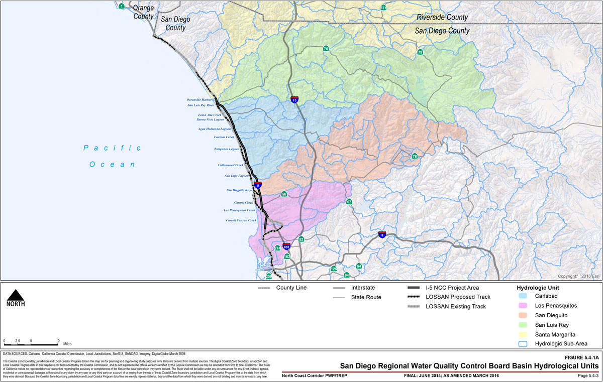
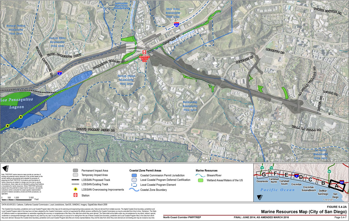
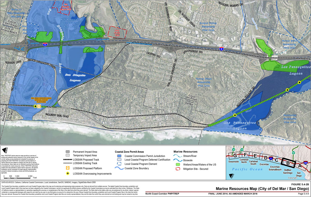
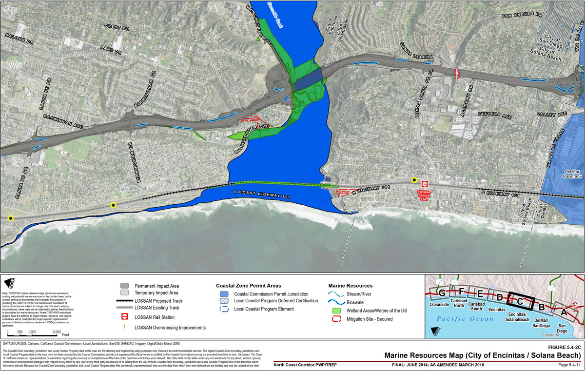
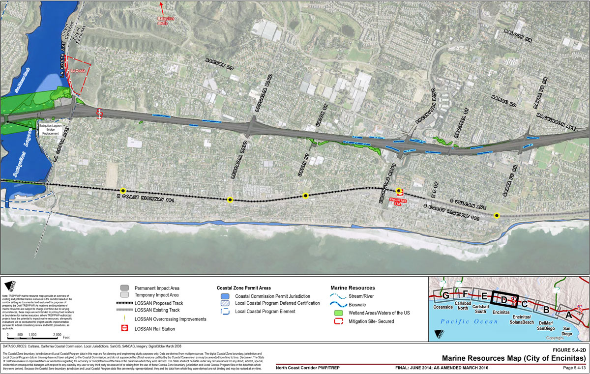
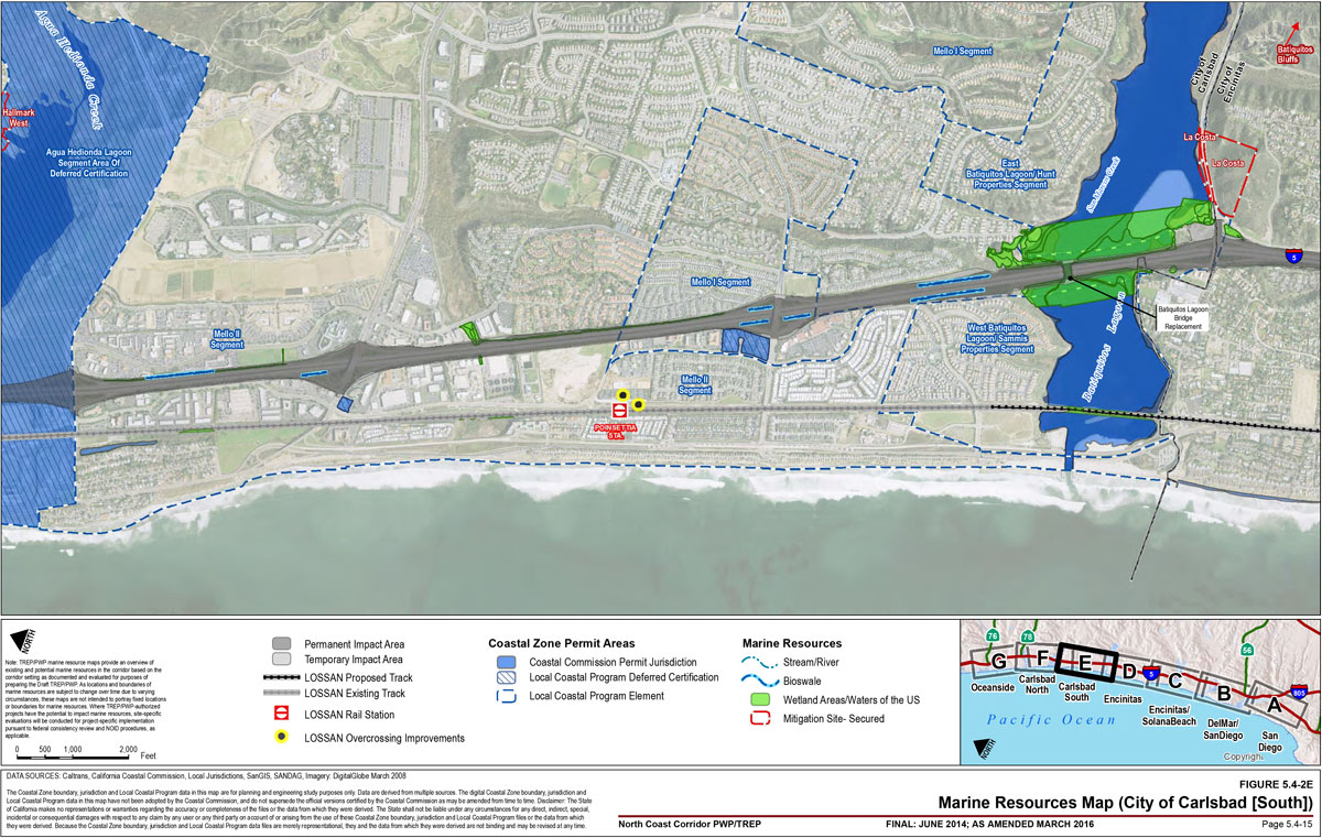
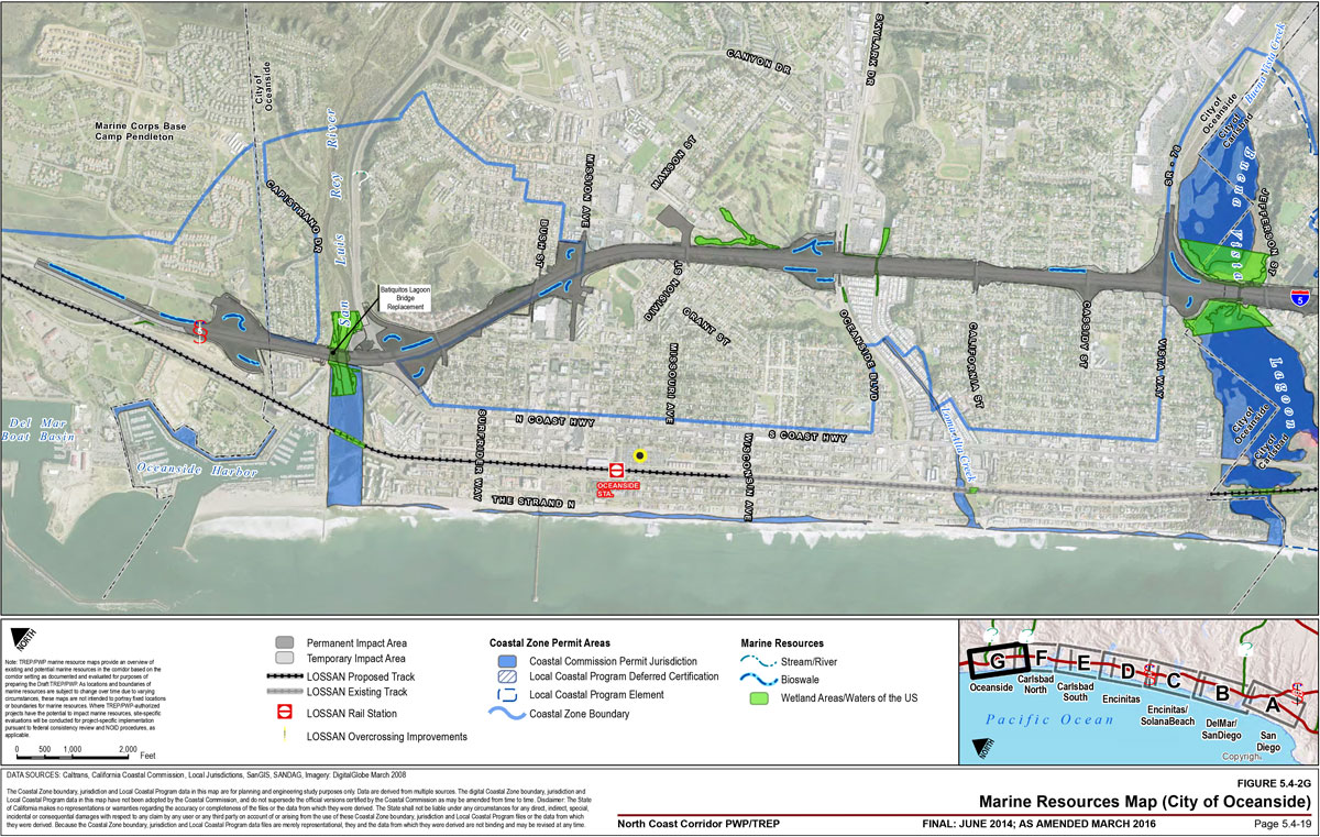
The NCC is located in a region that contains some of the most significant remaining coastal lagoons in Southern California. The corridor's lagoons, coastal water bodies, and smaller watershed drainages support a variety of marine resources including open water, wetland, and riparian habitats. Figure 5.4-1A illustrates the hydrologic units of the corridor, Figure 5.4-1B preliminarily identifies the percentage of pavement to be treated by sub-watershed within the I-5 corridor, and Figure 5.4-2A through Figure 5.4-2G provides an overview of existing and potential open water, wetland, and riparian habitat areas in the I-5 corridor based on the setting evaluated and documented for purposes of preparing the PWP/TREP. As the corridor's natural resources are subject to change throughout implementation of the PWP/TREP, the marine resource mapping included in Figure 5.4-2A through Figure 5.4-2G provide the baseline from which to evaluate potential project impacts to known and potential wetland resources, and to determine when the provisions of this section apply to future project implementation pursuant to the Notice of Impending Development (NOID) procedures enumerated in Chapter 6A.
5.4.1.1 Water Quality
The NCC area parallels the coastline throughout northern San Diego County and lies entirely within the coastal region of the San Diego Basin. As discussed in Chapter 2, the corridor improvement areas cross the following 5 of 11 hydrologic units (HUs) within the San Diego Regional Water Quality Control Board (RWQCB) Basin: The Santa Margarita, San Luis Rey River, Carlsbad, San Dieguito, and the Peñasquitos HUs. These HUs contain the corridor's coastal lagoons, the San Luis Rey River, and many other coastal streams, drainages, and wetland resources. Each HU has been developed to varying degrees and all are expected to experience between 7% and 14% more development by 2015.
While the corridor and entire San Diego coastal region have experienced rapid development over the last several decades, the corridor contains significant hydrologic features with many beneficial uses for San Diego residents, visitors, and natural resources. Surface hydrology within the corridor is influenced primarily by the coastal lagoons, creeks, and San Luis Rey River. The corridor contains six significant coastal lagoon systems including Los Peñasquitos, San Dieguito, San Elijo, Batiquitos, Agua Hedionda, and Buena Vista. In addition, the corridor includes the following significant coastal and inland waterways: Carroll Canyon Creek/Soledad Canyon Creek, Los Peñasquitos Creek, Carmel Creek, San Dieguito River, Cottonwood Creek/Moonlight Creek, Encinas Creek, Loma Alta Creek/Slough, Buena Vista Creek, the San Luis Rey River and Oceanside Harbor.
Figure 5.4-2A through Figure 5.4-2G illustrates the significant surface hydrologic features within the I-5 corridor including the lagoons, rivers, streams/creeks, and other drainages.
The California Coastal Basin Aquifer is the primary aquifer identified in the corridor. Shallow groundwater likely occurs adjacent to, or in the vicinity of, streams, rivers, and lagoons within the corridor and in the coastal bluff areas of Del Mar. Groundwater is also likely to saturate the surface and formational materials near alluvial or estuarine environments, such as the mouths of the major drainage areas and lagoons.
Beneficial Uses
The San Diego RWQCB Basin Plan (Basin Plan) defines "Beneficial Uses" for water bodies as those necessary for the survival or well-being of people, plants, and wildlife. The text below, as well as Table 5.4-1 and Table 5.4-2, provide information relative to beneficial uses for the corridor's lagoons and coastal and inland surface waters.
5.4.1.2 Corridor Lagoons
Corridor lagoons provide significant benefits in their respective watersheds for flood relief (by allowing high flows to slow and disperse into the larger water bodies) and for water quality (where sediment loads, nutrients, and toxins from stormwater are discharged and absorbed by vegetation within the lagoon prior to entering the ocean). As discussed in Chapter 2 (Section 2.2.6.2), the lagoons also contain sensitive habitat areas for threatened and endangered species and migratory birds, as well as for fish and many different wildlife species. In addition, were associated with open space and adjacent habitat preservation areas, the corridor lagoons provide habitat linkages and wildlife corridors in a coastal area that has experienced rapid population growth and urbanization over the last several decades. Most of the corridor lagoons provide public recreation amenities with trail systems, interpretative areas, wildlife observation opportunities, and, in some cases, expansive beach areas where the lagoons meet the ocean.
Beneficial Uses
Beneficial uses for the lagoons in the corridor generally include contact and non-contact recreation; preservation of biological habitats of special significance; estuarine habitat (potential estuarine habitat for Buena Vista Lagoon); marine habitat; wildlife habitat; rare, threatened and endangered species; fish migration; spawning, reproduction, and/or early development (with the exception of Buena Vista Lagoon, which is the only lagoon with the beneficial use of warm freshwater habitat). Beneficial uses for Los Peñasquitos and Agua Hedionda Lagoon include shellfish harvesting, with additional beneficial uses in Agua Hedionda for industrial service supply, commercial and sport fishing, and aquaculture. Loma Alta Slough is designated for contact and non-contact recreation, estuarine, marine and wildlife habitats, and rare, threatened, and endangered species. The mouth of San Luis Rey River is also designated for contact and non-contact recreation, marine habitat, wildlife habitat, and rare, threatened and endangered species, as well as for fish migration.

| Water Body Name | Industrial Service Supply | Contact Recreation | Non-Contact Recreation | Commercial/ Sport Fishing | Preservation of Biological Habitats of Special Significance | Estuarine Habitat | Wildlife Habitat | Rare, Threatened or Endangered Species | Marine Habitat | Aquaculture | Migration of Aquatic Organisms | Spawning, Reproduction and/or Early Development | Warm Freshwater Habitat | Shellfish Harvesting |
|---|---|---|---|---|---|---|---|---|---|---|---|---|---|---|
| Los Peñasquitos Lagoon | Existing Beneficial Use | Existing Beneficial Use | Existing Beneficial Use | Existing Beneficial Use | Existing Beneficial Use | Existing Beneficial Use | Existing Beneficial Use | Existing Beneficial Use | Existing Beneficial Use | Existing Beneficial Use | ||||
| San Dieguito Lagoon | Existing Beneficial Use | Existing Beneficial Use | Existing Beneficial Use | Existing Beneficial Use | Existing Beneficial Use | Existing Beneficial Use | Existing Beneficial Use | Existing Beneficial Use | Existing Beneficial Use | |||||
| Batiquitos Lagoon | Existing Beneficial Use | Existing Beneficial Use | Existing Beneficial Use | Existing Beneficial Use | Existing Beneficial Use | Existing Beneficial Use | Existing Beneficial Use | Existing Beneficial Use | Existing Beneficial Use | |||||
| San Elijo Lagoon | Existing Beneficial Use | Existing Beneficial Use | Existing Beneficial Use | Existing Beneficial Use | Existing Beneficial Use | Existing Beneficial Use | Existing Beneficial Use | Existing Beneficial Use | Existing Beneficial Use | |||||
| Agua Hedionda Lagoon | Existing Beneficial Use | Existing Beneficial Use | Existing Beneficial Use | Existing Beneficial Use | Existing Beneficial Use | Existing Beneficial Use | Existing Beneficial Use | Existing Beneficial Use | Existing Beneficial Use | Existing Beneficial Use | Existing Beneficial Use | Existing Beneficial Use | Existing Beneficial Use | |
| Buena Vista Lagoon | Existing Beneficial Use | Existing Beneficial Use | Existing Beneficial Use | Potential Beneficial Use | Existing Beneficial Use | Existing Beneficial Use | Existing Beneficial Use | Existing Beneficial Use | ||||||
| Loma Alta Slough | Existing Beneficial Use | Existing Beneficial Use | Existing Beneficial Use | Existing Beneficial Use | Existing Beneficial Use | Existing Beneficial Use | ||||||||
| Mouth of San Luis Rey River | Existing Beneficial Use | Existing Beneficial Use | Existing Beneficial Use | Existing Beneficial Use | Existing Beneficial Use | Existing Beneficial Use | ||||||||
| Oceanside Harbor | Existing Beneficial Use | Existing Beneficial Use | Existing Beneficial Use | Existing Beneficial Use | Existing Beneficial Use | Existing Beneficial Use | Existing Beneficial Use | Existing Beneficial Use | Existing Beneficial Use | Existing Beneficial Use |
| Water Body Name | Municipal/ Domestic Supply | Agricultural Supply | Industrial Service Supply | Contact Recreation | Non-Contact Recreation | Preservation of Biological Habitats of Special Significance | Warm Freshwater Habitat | Cold Freshwater Habitat | Wildlife Habitat | Rare, Threatened or Endangered Species | Spawning, Reproduction and/or Early Development |
|---|---|---|---|---|---|---|---|---|---|---|---|
| Carmel Creek | Excepted from Municipal | Existing Beneficial Use | Existing Beneficial Use | Potential Beneficial Use | Existing Beneficial Use | Existing Beneficial Use | Existing Beneficial Use | ||||
| Soledad Canyon Creek | Excepted from Municipal | Existing Beneficial Use | Existing Beneficial Use | Potential Beneficial Use | Existing Beneficial Use | Existing Beneficial Use | Existing Beneficial Use | Existing Beneficial Use | |||
| Carroll Canyon Creek | Excepted from Municipal | Existing Beneficial Use | Existing Beneficial Use | Potential Beneficial Use | Existing Beneficial Use | Existing Beneficial Use | Existing Beneficial Use | Existing Beneficial Use | Existing Beneficial Use | ||
| Los Peñasquitos Creek | Excepted from Municipal | Existing Beneficial Use | Existing Beneficial Use | Potential Beneficial Use | Existing Beneficial Use | Existing Beneficial Use | Existing Beneficial Use | Existing Beneficial Use | |||
| San Dieguito River | Excepted from Municipal | Potential Beneficial Use | Potential Beneficial Use | Existing Beneficial Use | Existing Beneficial Use | Existing Beneficial Use | Existing Beneficial Use | Existing Beneficial Use | Existing Beneficial Use | ||
| Canyon de Las Encinas | Excepted from Municipal | Potential Beneficial Use | Existing Beneficial Use | Existing Beneficial Use | Existing Beneficial Use | ||||||
| Loma Alta Creek | Excepted from Municipal | Potential Beneficial Use | Existing Beneficial Use | Existing Beneficial Use | Existing Beneficial Use | ||||||
| Buena Vista Creek | Excepted from Municipal | Existing Beneficial Use | Existing Beneficial Use | Existing Beneficial Use | Existing Beneficial Use | Existing Beneficial Use | Existing Beneficial Use | Existing Beneficial Use | |||
| San Luis Rey River | Excepted from Municipal | Existing Beneficial Use | Existing Beneficial Use | Existing Beneficial Use | Existing Beneficial Use | Existing Beneficial Use | Existing Beneficial Use | Existing Beneficial Use |
Restoration Efforts
Ongoing lagoon resource planning, restoration, and management has been implemented at varying levels for the corridor's lagoons and will continue to be essential in ensuring that the many floods, water quality, habitat, and recreational benefits of these significant watershed features are maintained and enhanced. Los Peñasquitos Lagoon, Batiquitos Lagoon, and Agua Hedionda Lagoon have been the subjects of various types of periodic restoration efforts, including inlet maintenance to allow for tidal circulation, bridge lengthening and repairs to improve circulation, maintenance dredging, water quality monitoring, and wetland and upland habitat restoration.
Buena Vista Lagoon, which contains part of the Buena Vista Lagoon Ecological Reserve maintained by the California Department of Fish and Wildlife (CDFW), is in "Phase II" of a focused restoration effort. Phase II prepares the preliminary engineering and environmental documents that depict various potential restoration alternatives for the lagoon.
The San Elijo Lagoon is part of the San Elijo Lagoon Ecological Reserve, where a focused restoration effort is underway. The San Elijo Lagoon Restoration Project is evaluating alternatives to improve the water quality of the lagoon through infrastructure improvements to promote tidal circulation. Improvements may include lagoon inlet enhancements through the lengthening of the bridge on South Coast Highway 101, and the lengthening of rail and highway facilities that cross the lagoon. Based on the analysis conducted for the San Elijo Lagoon Restoration Project and the I-5 project, the bridges will be lengthened to optimize the circulation of water, thereby creating wetland habitat within the existing bridge footprint and facilitating the restoration of marsh habitat through improved hydraulic flows.
The San Dieguito Lagoon has benefited from the completion of a major restoration effort implemented by Southern California Edison. The San Diego Association of Governments (SANDAG) is working on expanding the extent of the restored coastal wetlands.
Irrespective of current restoration efforts, all of the corridor lagoons require ongoing management to address the effects of increased year-round freshwater input, accelerated sedimentation and water contamination, reduced tidal mixing, the introduction of exotic species, revegetation of disturbed areas, and impacts on habitats and wildlife from adjacent development and recreational use.
Chapter 2 (Section 2.2.6.2) provides a description of each of the corridor lagoons and details the lagoons' ownership, general size, and associated watershed features, habitats, and past and pending planning and restoration efforts. Table 5.4-3 provides a summary of this information in addition to information regarding the status of long-term management, land uses, the surrounding transportation system, and various factors affecting lagoon system health.
5.4.1.3 Other Corridor Wetlands and Riparian Habitats
Wetland and riparian habitat areas are also found in a number of other coastal and inland waterways within the corridor's watersheds including Carroll Canyon Creek (Soledad Canyon Creek), Los Peñasquitos Creek, San Dieguito River, Carmel Creek, Cottonwood Creek/Moonlight Creek, Encinas Creek, Loma Alta Creek/Slough, Buena Vista Creek, and the San Luis Rey River. A number of wetland and riparian habitat types are associated with the various water bodies identified in the corridor including southern riparian, southern riparian forest, southern cottonwood-willow, riparian forest, and San Diego mesa hardpan vernal pool. Southern willow scrub, mulefat scrub, freshwater marsh, southern willow scrub/freshwater marsh, southern arroyo willow woodland, coastal brackish marsh, southern coastal salt marsh, salt marsh transition, Arundo scrub, disturbed wetland, mudflat, salt flat, and open water.
Carroll Canyon Creek (Soledad Canyon Creek), Los Peñasquitos Creek, and Carmel Creek all drain the Los Peñasquitos watershed and ultimately discharge into the Pacific Ocean via Los Peñasquitos Lagoon. Carroll Canyon Creek originates southeast of the Miramar Reservoir, in the City of San Diego neighborhood of Scripps Miramar Ranch and feeds into Soledad Canyon Creek. Soledad Canyon Creek has been channelized through Sorrento Valley in a concrete-lined channel for approximately 0.5 miles and converges with Los Peñasquitos Creek, which flows in a natural channel until it reaches Los Peñasquitos Lagoon. Los Peñasquitos Creek drains Los Peñasquitos Canyon, which stretches east of Poway. The San Dieguito River drains the San Dieguito Hydrologic Unit. From the dam forming Lake Hodges, the San Dieguito River flows through the long and narrow San Dieguito River Park past Del Mar and broadens into a tidal waterway and lagoon as it crosses under I-5 to empty into the Pacific Ocean at Solana Beach. Carmel Creek, fed by tributaries to the east, is located in San Diego just south of Carmel Valley Road and drains through a concrete box culvert under Sorrento Valley Road. These creeks include wetland and riparian areas, and convey flood flows and provide water quality benefits.
Cottonwood Creek and Moonlight Creek flow through an urbanized section of Encinitas. Cottonwood Creek is a small creek that flows intermittently above- and belowground through Encinitas between San Elijo and Batiquitos Lagoons. Cottonwood Creek is primarily channelized or underground near I-5; however, several drainages feed into Cottonwood Creek from the east to west side of I-5 where the outlet to the Pacific Ocean at Moonlight Beach has recently been restored. Restoration efforts have also included the creation of Cottonwood Creek Park west of I-5 where the creek channel has been restored to an aboveground channel between I-5 and the ocean. Cottonwood Creek does not provide substantial flood relief, water quality improvement, or wildlife habitat until reaching the newly restored channels in Cottonwood Creek Park. Moonlight Creek is a small tributary in Cottonwood Creek Park that runs parallel to and west of I-5. Moonlight Creek primarily conveys urban runoff from both sides of I-5 into Cottonwood Creek and supports some freshwater marsh habitat and southern willow scrub, providing habitat to riparian bird species and limited water quality and flood relief benefits.
Encinas Creek is part of the Encinas watershed, which is 3,434 acres in size within the larger Carlsbad Hydrologic Unit. The watershed extends 2.37 miles inland from the coast and the high elevation within the drainage is approximately 430 feet above mean sea level. The watershed begins as small drainage in an industrial area and is immediately channelized. The creek continues through industrial and office parks associated with Palomar Airport until it reaches the lower valley area. It then makes its way to the Pacific Ocean after crossing I-5 and Pacific Highway.
Loma Alta Creek is a highly disturbed creek beginning in Vista and running through primarily urban areas in Oceanside. The creek flows parallel to Oceanside Boulevard through both natural and concrete-lined channels. After running under I-5 through a pipe, Loma Alta Creek runs into Loma Alta Slough, located north of Buccaneer Beach Park, before ultimately flowing into the Pacific Ocean. The Slough is considered a coastal estuarine wetland. Loma Alta Watershed is the northernmost watershed in the Carlsbad Hydrologic Unit Loma Alta Creek provides some water quality filtration and conveys storm flows and urban runoff; however, these benefits are minimized by the highly disturbed nature of the Creek.
| Los Peñasquitos | San Dieguito | San Elijo | Batiquitos | Agua Hedionda | Buena Vista | |
|---|---|---|---|---|---|---|
| Lagoon Owner/Operator |
|
|
|
|
|
|
| Size | 565 acres | 456 acres | 491 acres | 600 acres | 400 acres | 203 acres |
| Watershed Features |
|
|
|
|
Agua Hedionda Creek | Buena Vista Creek |
| Habitat |
|
|
|
|
|
|
| Special-Status Species |
|
|
|
|
|
|
| Past & Present Restoration Efforts |
|
|
|
|
|
|
| Long-term Monitoring/Management |
|
|
|
|
|
|
| Land Use |
|
|
|
|
|
|
| Transportation Facility Crossings |
|
|
|
|
|
|
| Lagoon System Concerns |
|
|
|
|
|
|
Buena Vista Creek is part of the Carlsbad watershed that drains to the Pacific Ocean via Buena Vista Lagoon. The creek experiences seasonal flows typical of most coastal drainages in San Diego County. However, artesian springs provide for some surface flow even during the summer dry season. During wet winter weather or flood events, surface flow increases significantly into Buena Vista Lagoon. Natural surface flows are augmented by urban and agricultural runoff. Most of the recreational uses are focused along the lower portions of Buena Vista Creek and around Buena Vista Lagoon, which is heavily used as a bird-watching location. Sedimentation could pose a long-term threat to the freshwater marsh and open water mosaic that exist.
The San Luis Rey River is a significant resource and riparian feature within the corridor and is one of the few perennial rivers in San Diego County. The San Luis Rey River reach located within the corridor is a combination of open water habitat, freshwater marsh, Arundo scrub, and riparian habitat that supports a variety of common and sensitive wildlife species. San Luis Rey River supports listed species, such as the tidewater goby, steelhead, and southern willow catcher, amongst others. San Luis Rey River also plays an important role in conveying storm flows, potential flood relief, and improving water quality from filtering from freshwater marsh species.
Beneficial Uses
All of the inland waterways provide the following beneficial uses (or have the potential to provide beneficial uses): agricultural supply, industrial services supply, contact, and non-contact recreation, warm water habitat, and wildlife habitat. Exceptions are Encinas and Loma Alta Creeks, which are not designated for agricultural supply or industrial services supply. Additional beneficial uses include cold freshwater habitat for Soledad Canyon, Carroll Canyon Creek, and San Dieguito River. Beneficial use for rare threatened and endangered species are also assigned to Carroll Canyon Creek, Buena Vista Creek, and San Luis Rey River. Los Peñasquitos Creek is designated for the preservation of biological habitats of special significance.
5.4.2 PWP/TREP Concerns
Environmental documentation and analysis prepared for the PWP/TREP rail and highway corridor improvements indicate that significant marine resources occur in the corridor, including coastal lagoons, rivers, streams, other wetland areas, and the Pacific Ocean, which could be affected by the implementation of the proposed improvements. In addition, environmental documentation demonstrates that many of the corridor's significant marine resources, have experienced and will continue to experience varying degrees of ongoing degradation due to adjacent development stressors and the existing transportation facilities included in the PWP/TREP.
5.4.2.1 Existing Water Quality Deficiencies
Chapter 3A identifies resource deficiencies in the corridor related to water quality and discusses these deficiencies in the context of runoff from corridor urbanization, development and transportation facilities, current transportation facility treatment levels of runoff, the quality of water entering the corridor's water bodies and the ocean, and impaired waterbodies. The corridor's coastal water bodies have experienced decades of degradation from direct and indirect impacts of development, including the transportation facilities that cross these resources, which has negatively affected water quality that is essential for protecting coastal resources and maintaining water-oriented recreational use.
Corridor urbanization and development have cumulatively affected water quality as impermeable surfaces have increased and the vegetative cover has decreased. This has resulted in significant increases in stormwater pollutant loads and runoff velocity and volume, contributing to excessive erosion and sedimentation within corridor watersheds. Hydrology and water quality are also potentially affected in the coastal bluff areas of Del Mar along the rail facility where ongoing shoreline erosion problems caused by wave action require ongoing maintenance activities along or within the shoreline to ensure the facility is protected from failure.
The corridor transportation infrastructure generally conveys pollutants to surface waters, which are most often generated from roadways, parking lots, and disturbed landscapes. However, highway facilities are only a small percentage of the land area (2%) in the NCC, and I-5 also accounts for less than 2% of the tributary area of the five NCC watersheds. Table 5.4-4 lists the hydrologic areas and subareas that encompass the proposed NCC and compares those areas to the existing NCC I-5 highway right-of-way. As indicated, the maximum tributary area and highway contribution to the hydrologic areas/subareas is less than 2%.
| Watershed | Hydrologic Area (HA)/ Subarea (HSA) Name | HA/HSA Number | HA/HSA (Acres) | Existing I-5 Tributary Area (Acres) | Existing I-5 Contribution to HA/HSA (%) |
|---|---|---|---|---|---|
| Peñasquitos | Miramar HA | 906.40 | 25,924 | 288 | 1.10 |
| Peñasquitos | Miramar Reservoir HA | 906.10 | 32,594.8 | 332 | 1.02 |
| San Dieguito | Rancho Santa Fe HSA | 905.11 | 22,610.5 | 221 | 0.98 |
| Carlsbad | San Elijo HSA | 904.61 | 20,721.5 | 181 | 0.88 |
| Carlsbad | Batiquitos HSA | 904.51 | 17,819.4 | 330 | 1.85 |
| Carlsbad | Encinas HA | 904.40 | 2,991.4 | 47 | 1.56 |
| Carlsbad | Los Monos HSA | 904.31 | 11,904.4 | 95 | 0.8 |
| Carlsbad | El Salto HSA | 904.21 | 7,476.4 | 134 | 1.79 |
| Carlsbad | Loma Alta HSA | 904.10 | 5,199.6 | 40 | 0.78 |
| San Luis Rey | Mission HSA | 903.11 | 29,930 | 114 | 0.38 |
| Santa Margarita | Lower Ysidora HSA | 902.11 | 6,710 | 38 | 0.57 |
Potential pollutants from the roadway and slopes include sediment, nutrients (nitrogen and phosphorus) from native and ornamental vegetation, metals (copper, lead, and zinc), fertilizers, and pesticides. Other than runoff from parking structures associated with the rail facilities, runoff from rail improvements are relatively minor because of limited impermeable surface area associated with rail lines.
The corridor contains a number of impaired water bodies that do not meet water quality standards (as defined by the Clean Water Act ), and therefore cannot support the beneficial uses for which the water body has been designated. Chapter 3A identifies impaired water bodies in the corridor (303(d) list), which include Los Peñasquitos Creek, Los Peñasquitos Lagoon, Soledad Canyon Creek, the Pacific Ocean at San Dieguito Lagoon, San Elijo Lagoon, Buena Vista Lagoon, Loma Alta Slough, the Pacific Ocean at the San Luis Rey River mouth, the San Luis Rey River, and Oceanside Harbor. Inland waterways that are tributaries of, or discharge into, these 303(d) impaired waters may also be considered part of the 303(d) listed water bodies.
A number of impaired water bodies were given special status under the Clean Water Act for which the state is required to identify waters that will not achieve water quality standards after the application of effluent limits. For these impaired water bodies, states are required to develop plans for water quality improvement. The plans consider each water body and pollutant for which water quality is considered impaired and include load-based (as opposed to concentration-based) limits called total maximum daily loads (TMDL), which is the maximum amount of pollution (both point and non-point sources) that a water body can assimilate without violating state water-quality standards. For example, a TMDL for Los Peñasquitos Lagoon was adopted by the San Diego Regional Water Quality Control Board on June 13, 2012. Caltrans is listed as a responsible party on the TMDL, and North County Transit District is also a responsible party because it is enrolled in the Greater San Diego Phase II Municipal Separate Storm Sewer (MS4) Permit issued by the State Water Resources Control Board on February 5, 2013. The responsible parties for this TMDL are required to meet specific targets for the restoration of salt marsh in the Los Peñasquitos Lagoon.
Chapter 3A identifies pollutants discharging with a load or a concentration that commonly exceed allowable standards and that are considered treatable by Caltrans' approved treatment BMPs, which are referred to as Targeted Design Constituents (TDCs). See Table II.2 within the I-5 NCC Water Quality Technical Memorandum (Appendix E of the PWP/TREP) for details on which 303(d) listed waterbodies will be potentially affected by the implementation of transportation improvements. TDCs in the corridor include sediment, metals (total and dissolved zinc, lead, and copper), nitrogen, phosphorus, and general metals. Caltrans developed and implemented a BMP Retrofit Pilot Program to combat these TDCs that was finalized in January 2004 for several locations along the I-5 corridor. The pilot program for runoff in the corridor highway facility included detention devices at I-5 and SR 56, I-5 and Manchester Avenue, a wet basin at I-5 and La Costa Avenue, media filters at the La Costa Park & Ride and the SR-78 and I-5 Park & Ride, and a biofiltration system at I-5 and Palomar Airport Road. These facilities were able to treat about 7% (approximately 47 acres) of the total existing paved area in the NCC. The 7% treatment accounts for the identified pilot projects, as well as treatment BMPs completed as part of previous construction projects within the corridor such as I-5/805 and I-5/Lomas Santa Fe. Consistent with federal and state law, as well as with the terms of its National Pollutant Discharge Elimination System (NPDES) permit, Caltrans also implemented maintenance BMPs that included preventative measures to ensure that ongoing maintenance activities be conducted in a manner that reduces the number of pollutants discharged to surface waters via Caltrans stormwater drainage systems. Maintenance BMPs were implemented in accordance with the Storm Water Quality Handbook-Maintenance Staff Guide, which provides detailed instructions on applying approved stormwater maintenance BMPs to maintain facility operations and highway activities in a manner that provides maximum protection of water quality.
Table 5.4-5 provides a tabular reference to the Caltrans Storm Water Quality Handbook Project Planning and Design Guide's (PPDG) Appendix E treatment BMP checklists T-1 to T-10 along with Figure 2-3 - Decision Process for Selecting Treatment BMPs at Specific Sites. For the selection of conceptual BMPs, the design team has prepared and preliminarily quantified treatment BMP water quality flows, tributary areas and percent treatment as shown in Section 5.4.2.4.
| Biofiltration Systems | Infiltration Devices | Detention Devices | Dry Weather Flow Diversions (Dry weather flow diversions address non-stormwater flows only) |
Gross Solids Removal Devices | Multi- Chambered Treatment Train | Media Filters | Wet Basins | Traction Sand Traps | |
|---|---|---|---|---|---|---|---|---|---|
| Total Suspended Solids | X | X | X | X | X | X | X | X | |
| Total Dissolved Solids | X | ||||||||
| Nutrients | X Soil needs to have adequate infiltration capacity. |
X | X Soil needs to have adequate infiltration capacity. |
X | X Phosphorus and nitrogen for the Austin Sand filter; phosphorus only for the Delaware Sand filter. |
X Reductions observed for dry weather flow only. |
|||
| Pesticides | X | X | |||||||
| Particulate Metals | X | X | X | X | X | X | X | ||
| Dissolved Metals | X | X | X | X | X | ||||
| Pathogens | X | X | X | ||||||
| Litter | X | X | X | X | X | X | X | ||
| Biochemical Oxygen Demand | X | X | X | ||||||
| Turbidity | X | X | X | X | X | X | X | X |
Existing Lagoon Deficiencies
Chapter 3A also identifies resource deficiencies in the context of the corridor's lagoons and associated sensitive habitat areas. Corridor lagoons have historically experienced adverse impacts to water quality and to the varied habitat areas, plant, and wildlife species supported within and adjacent to the lagoons. The hydrology of the watersheds in the corridor has been directly altered by adjacent development and the existing highway and rail facilities, which have displaced watershed features including lagoon, river, stream, and drainage areas. In addition, realignment and/or channelization of inland waterways conveying stormwater through the watersheds to coastal water bodies have also resulted in significant modification to the hydrology of the lagoons within the corridor. The physical alterations of watershed features have resulted in a cumulative loss of wetland and riparian habitat areas that, in turn, has decreased the valuable biological function of these areas to naturally dissipate and filter sediment and pollutants in stormwater runoff prior to discharge to the lagoons and eventually the Pacific Ocean. In addition to direct displacement of habitat area resulting from adjacent development and construction of the corridor transportation facilities, watershed alterations such as the diversion of freshwater from inland waterways, excess sedimentation and siltation, and, in some cases, reconfiguration of the lagoons' inlet at the ocean, have all contributed to degradation of lagoon resources. Development encroachment has also reduced the amount and quality of transitional and upland habitat areas that typically provide buffers between adjacent land uses and the habitats and species supported by the lagoons.
The health of the lagoons in the corridor is based, in large part, on the extent to which waters are free-flowing or stagnant in each system. This health directly affects the quality of habitat provided for lagoon-dependent wildlife, as well as how well the lagoons function for passive recreational purposes (reflected in the health of vegetation, lack of odor, etc.). The I-5 NCC Project Final EIR/EIS details the results of a number of studies undertaken by SANDAG/Caltrans to identify existing and proposed rail and highway bridge dimensions in context with known environmental concerns for each lagoon system, with analysis of the potential effects of the proposed bridge modifications on tidal circulation, flood flows and associated scour, sediment transport, sea-level rise relative to freeboard, wildlife connectivity, channel protection features, and associated impacts on wildlife habitats and federal or state jurisdictional waters/wetlands. The analysis of each lagoon also addresses constraints presented by the Pacific Coast Highway 101 transportation corridor. The analyses confirm that existing rail and highway bridges at San Elijo, Batiquitos, and Buena Vista Lagoons were identified as potentially posing more substantial constrictions (relative to tidal circulation, flood flow, etc.), with a potential for optimization, and additional technical studies were undertaken to identify how the replacement bridges could be designed to optimize tidal and fluvial flows in these systems. In addition, there are plans for large-scale restoration efforts at San Elijo and Buena Vista Lagoons where existing bridges could restrict the range of restoration alternatives under consideration for these lagoons.
5.4.2.2 Potential PWP/TREP Project Impacts
PWP/TREP concerns for protection and enhancement of marine resources relate to proposed project impacts that may occur from construction, operation, and maintenance of the rail and highway facilities, and community enhancement improvements, which include new and enhanced recreation facilities. The PWP/TREP improvement areas are located within and/or drain directly to a number of coastal water bodies and proposed improvements that could individually or cumulatively result in short-term construction or long-term operational water quality and marine habitat impacts. Transportation improvements and facilities often generate sources of pollutants that are carried by runoff to adjacent water bodies, thus affecting water quality and sensitive marine resources.
The proposed PWP/TREP improvements would result in changes to the project area land surface through grading and increased impervious surfaces, which could increase peak runoff rates and volume and pollutant loads from pre-development levels. PWP/TREP improvements would also require grading and landform modification that could disrupt and/or interfere with surface water flow and natural attenuation of runoff by drainage features, resulting in increased peak flood discharge, erosion, and sedimentation to receiving water bodies. In addition, potential erosion and sedimentation impacts are of concern where existing rail improvements along Del Mar Bluffs require construction activities for the maintenance of existing shoreline protection devices. Implementation of the PWP/TREP improvements could also cause impacts on water quality due to increased runoff and erosion from grading and vegetation removal. Other construction-related impacts may include accidental discharge and spill of construction debris and pollutants from construction equipment, demolition activities with bridge improvement and replacement projects, and construction activities along the railway on Del Mar Bluffs.
However, without the proposed PWP/TREP infrastructure improvements, the corridor's water quality, and lagoon, wetland, and riparian habitat areas will continue to degrade. The proposed transportation infrastructure improvements, when combined with the PWP/TREP Resource Enhancement and Mitigation Program (detailed in Chapter 6B), could significantly restore and enhance marine resources and thereby improve many of the existing deficiencies of the corridor's water quality, lagoon, wetland, and riparian habitat areas. Existing LOSSAN rail and I-5 highway transportation facilities contribute to degraded water quality and marine habitat due to previous transportation construction practices that displaced marine habitats, and which also limit opportunities for retrofitting facilities to improve water quality. Absent the proposed PWP/TREP facility improvements, opportunities to modify existing transportation infrastructure to improve existing deficiencies of water quality, lagoon, wetland, and riparian habitat resources would remain extremely limited and unlikely. As such, PWP/TREP improvements are planned and designed to remedy impacts to water quality and marine resources caused by previous construction and/or ongoing operations of the existing transportation facilities to the extent feasible. Implementing the PWP/TREP would thereby facilitate enhancement and restoration of the biological productivity and quality of marine resources including coastal waters, lagoons, and streams.
5.4.2.3 LOSSAN Rail Corridor Impact Assessment
Proposed rail facility track improvements would not result in a significant expansion of impermeable surfaces and thus would not contribute substantially to increased stormwater runoff. The majority of rail improvements would be contained within the existing right-of-way or in deep tunnels and, thus, would minimize the need for excessive grading and landform modification that could otherwise disrupt and/or interfere with surface water flow or result in increased peak flood discharge, erosion, and sedimentation to receiving water bodies. Rail improvements include parking area expansion at, adjacent to, or in close proximity to stations and a new platform at Del Mar that would involve increased impervious surfaces and could contribute to increased runoff, erosion, and pollutant loads to receiving water bodies; however, with the exception of the proposed platform at Del Mar, all stations now have or are developing, vertical parking structures in already developed areas. It is expected that proposed parking resources would likely be met through additional parking levels in the existing structures; therefore, the impervious surface at ground level would not increase substantially.
Potential hydrology and water quality impacts related to the construction of rail improvements could result from ground-disturbing activities for double-tracking, at shafts, portals, grade separations, and staging areas. Sources of stormwater pollution during construction could include equipment and vehicle leaks of oil, grease, fuel, etc., construction materials, and waste material. Though not specifically addressed in the Los Angeles-San Diego-San Luis Obispo (LOSSAN) Final Program EIR/EIS, but based on data presented in the I-5 NCC Project Final EIR/EIS (October 2013), Essential Fish Habitat (EFH) could occur within the rail corridor in San Dieguito, Batiquitos, Agua Hedionda, and San Elijo Lagoons. These possible EFHs could be impacted by any degradation in water quality and/or hydrology. Eelgrass beds grow sub-tidally and are important habitats for aquatic species and have specific regulations concerning impacts and mitigation. Subtidal portions of the lagoons within the study area were surveyed in 2006 for current eelgrass and possible invasive algae (i.e. Caulerpa taxifolia) distributions for purposes of identifying potential impacts. Eelgrass was observed in Batiquitos and Agua Hedionda Lagoons. Eelgrass habitat could be impacted by degraded water quality and hydrology.
As part of the conceptual design at the program level, the lead agencies have proposed, at a minimum, maintaining either the same in-water footprint or reducing the number of in-water columns compared to the existing rail corridor bridges; however, proposed rail improvements would likely result in unavoidable fill impacts to wetlands. Preliminary assessment indicates that approximately 7.45 acres of total wetland habitat within the rail corridor could be directly impacted by proposed rail improvements in the first three phases of the PWP/TREP Phasing Plan. Within Oceanside and Carlsbad, there would be approximately 0.63 acres of potential wetland impact due to proposed rail projects. Within Encinitas and Solana Beach, approximately 5.65 acres of wetlands are mapped within the proposed rail alignment options, while approximately 1.17 acres are mapped within the Del Mar and San Diego area.
An additional 11.8-12.6 acres of wetland impacts could occur with the implementation of the two doubletrack rail projects in Del Mar and San Diego included in the vision (final) project phase, depending on the future tunnel alternative selected. Either tunnel option in the Del Mar area would involve deep tunneling that would avoid disturbance along the tunnel routes to most wetland resources, except potentially at portal areas, like through the CDFW Preserve in San Dieguito Lagoon. The Camino Del Mar tunnel option would involve double-tracking across the Los Peñasquitos and San Dieguito lagoons on existing or new rail bridges, which could be done without net increase of the in-water footprint of the rail infrastructure within the lagoons. Construction along the lagoon perimeters would have direct and indirect impacts on wetland areas during construction. There may be the opportunity to replace the existing bridge across Los Peñasquitos with a causeway structure that would increase the tidal flow and remove the embankment from the lagoons. This would require extensive in-water work, causing higher impacts during construction, but would result in a long-term beneficial impact on the lagoon, which would be determined in project-level analyses. The I-5 tunnel option would avoid crossing Los Peñasquitos Lagoon, but the design concept would include a new, elevated structure along the south edge of San Dieguito Lagoon, following the southern edge of San Dieguito Racetrack View Drive, which may result in potentially new, temporary and permanent impacts on wetland resources. The I-5 tunnel option would allow for the removal of the existing Los Peñasquitos rail bridge structures in the future, which would have temporary impacts on the lagoon from in-water work to remove the existing structure but ultimately create better tidal circulation in the lagoon.
Table 5.4-6 provides a breakdown of potential rail corridor wetland impacts versus available mitigation credits according to the project phases (the full PWP/TREP Phasing Plan is presented in Chapter 6A).
Temporary Impacts
In all cases, temporary construction impacts from project activities in and around the lagoons could affect habitats associated with the lagoons. Potential impacts include in-water work for new infrastructure, possible removal of existing structures, turbidity, and increased sedimentation during construction; however, as discussed below, it is also anticipated that proposed bridge replacement projects over the lagoons and other coastal water bodies could have a beneficial effect on hydrology and water quality by constructing new bridges that better convey floodwaters, allow for improved tidal flushing, and thereby improve water quality and marine resources.
5.4.2.4 I-5 Highway Corridor Impact Assessment
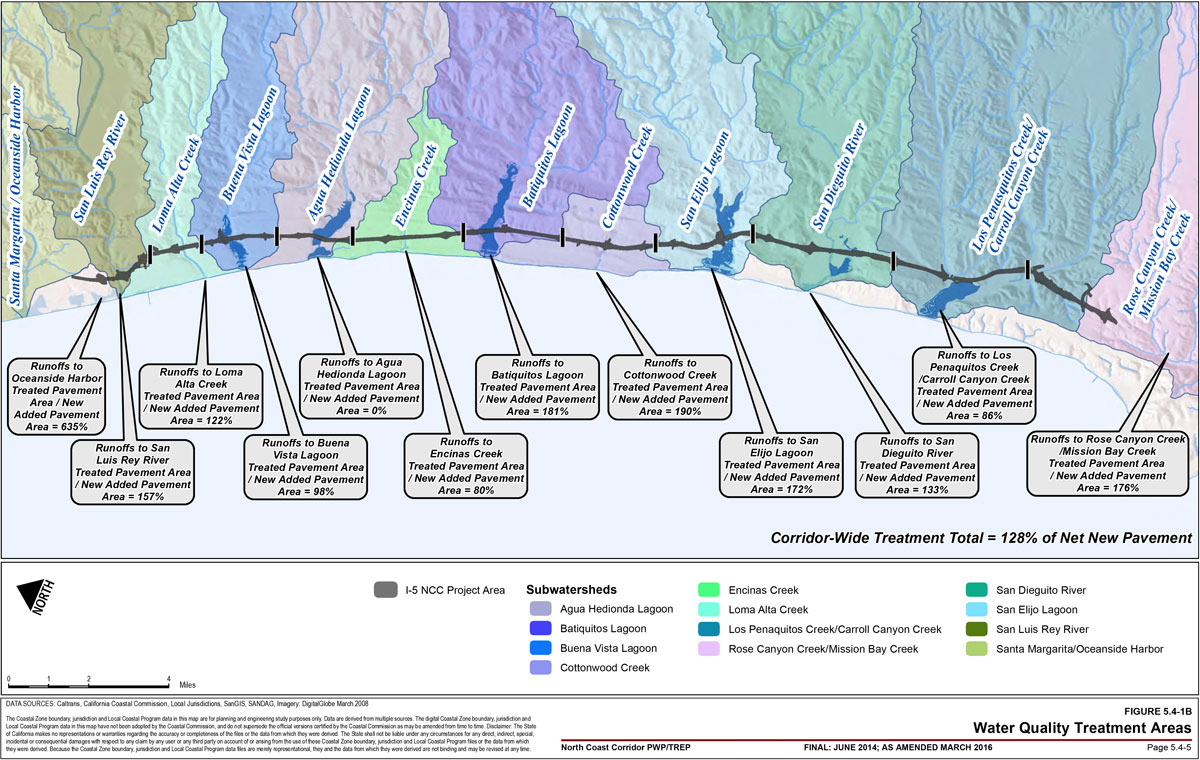
Operational and construction activities for the proposed highway improvements could affect water quality and marine habitats. The I-5 NCC Project Final EIR/EIS compares and analyzes existing and proposed additional pavement areas between the four proposed to Build Alternatives, and discusses in detail the effects of the Locally Preferred Alternative (LPA) on corridor water quality and marine habitats. A number of existing treatment BMPs are present within the project limits, including biofiltration swales, extended detention facilities, wet basins, and media filters; with these facilities providing treatment for runoff from associated paved areas within the I-5 corridor. The percentage of runoff that is treated by existing treatment BMPs is approximately 7%. The LPA could modify local drainages and alter some of the existing treatment tributary areas. The existing and proposed amounts of impervious areas within the project limits were quantified based on average directional dimensions for general purpose lanes, auxiliary lanes, median, on- and off-ramps, and local streets within Caltrans right-of-way. The existing impervious area within the I-5 corridor is approximately 670 acres, of which 7% is treated through existing BMPs. The LPA would result in approximately 225 acres of new impervious area (for a combined impervious area of 895 acres) with treatment proposed for approximately 287 acres. The proposed preliminary BMP siting results in 128% of the net new equivalent impervious area treated or 32% of the total impervious area treated by both existing and proposed treatment BMPs corridor-wide. These estimates reflect a general baseline condition for the entire corridor; as the project-specific design progresses, the percentage of treatment is anticipated to increase as new or enhanced treatment BMP opportunities are identified for the feasibility of incorporation through the project development process. For example, existing treatment BMPs would be assessed to determine those to remain in place with or without modification, relocation, retrofitting, or upsizing. Likewise, new treatment BMP opportunities will be assessed for incorporation based on final drainage and grading, design, and potential impacts.
Additionally, enhanced infiltration of stormwater by conveyance to open areas that filter and detail runoff through existing soils, landscaping, vegetation and wetlands, otherwise known as enhanced infiltration through the natural environment, would be maximized throughout the corridor. Table 5.4-7 includes a breakdown of existing and proposed stormwater treatment by watershed area using Caltrans-approved BMPs for NPDES permit compliance. Enhanced infiltration opportunities that simply convey runoff to vegetation and wetlands are not classified as Caltrans-approved BMPs for NPDES permit compliance and therefore are not reflected in the baseline treatment percentages presented in Table 5.4-7.
However, in areas such as Agua Hedionda Lagoon where quantifiable treatment by Caltrans-approved treatment BMPs may not be feasible due to ROW impacts, ecological sensitivity or topographic constraints, enhanced infiltration through the natural environmental will be maximized within that sub-watershed to benefit water quality and shall be documented in the Water Quality Management Plan (WQMP) or an expanded-format Storm Water Data Report (SWDR). See Table 5.4-7(A-C) for proposed stormwater treatment for the San Elijo HOV project that utilizes, in addition to Caltrans approved BMPs, conveyance of runoff to soils, landscaping, vegetation, and wetlands to utilize enhanced infiltration through the natural environment. The expanded-format of the SWDR would capture and document where opportunities to use enhanced infiltration through the natural environment would be available, as well as showing where BMP capacities can be maximized, similar to that shown in Table 5.4-8(A-C).
Specifically, Table 5.4-8A, Table 5.4-8B, and Table 5.4-8C provide examples of the project-specific treatment BMP analysis that will be completed as project design progresses and site-specific hydraulic data becomes available (i.e., at Preliminary Design, at 30% Design, and greater). This ensures that the percentage of treatment feasible by watershed, as currently indicated in Table 5.4-7, would be to the maximum extent practicable and contribute to minimizing adverse impacts to water quality throughout the corridor. As shown in the following tables, siting of new and/or additional treatment BMPs that incorporate Low Impact Development (LID) principles, is based on contributing areas; however, the location of these BMPs undergo a screening analysis, including a cost-benefit analysis, that considers new or increased visual, right-of-way, environmentally sensitive habitat areas (ESHA), and/or wetland impacts. The SWDR will document the appropriate treatment BMPs selected after conducting a similar analysis as demonstrated within Table 5.4-8A, Table 5.4-8B, and Table 5.4-8C.
The increased impervious area introduced by projects consolidated under the PWP/TREP is significant in the context of the existing highway facility; however, the maximum Caltrans contributing tributary area is still small relative to the size of any of the hydrologic areas/subareas in the corridor (see Table 5.4-7).
In addition, pollutants from construction activities could be generated from construction materials as well as construction activities. Pollutants generated from construction materials could include vehicle fluids, asphaltic emulsions from paving activities, joint and curing compounds, concrete curing compounds, solvents and thinners, paint, sandblasting material, landscaping materials, treated lumber, PCC rubble, and general litter. Pollutants from construction activities could include clearing and grubbing, grading operations, soil import operations, sandblasting, landscaping, and utility excavation.
Table 5.4-6: Permanent Wetland Impact vs. Mitigation (By Year/Phase)
2010-2020 Phase1
- Initial-Term Total Impact = 12.52 Acres
- Initial-Term Total Mitigation = 72.81 Acres
Year 2013
| Transportation Improvements | Impacts2 (Acres) |
Mitigation Site | Wetland Establishment (Acres) |
Wetland Restoration (Acres) |
Variable No-Net-Loss Mitigation (Releases 1 & 2 @ 30%) |
|---|---|---|---|---|---|
| Oceanside Through Track (2013) | 0 | None underway | 0 | 0 | 0 |
| Poinsettia Station Improvements (2013) | 0 | None underway | 0 | 0 | 0 |
Year 2014
| Transportation Improvements | Impacts (Acres) |
Mitigation Site | Wetland Establishment (Acres) |
Wetland Restoration (Acres) |
Variable No-Net-Loss Mitigation (Releases 1 & 2 @ 30%) |
|---|---|---|---|---|---|
| No improvements scheduled for 2014 | 0 | Hallmark (Agua Hedionda) | 4.37 | 0.97 | 1.31 |
| No improvements scheduled for 2014 | 0 | Regional Lagoon Maintenance Program (Endowment Established; *10% Proposed for Release Upon Establishment, Contingency Pool project) |
20.7 | 0 | 2.07 |
Year 2015
| Transportation Improvements | Impacts (Acres) |
Mitigation Site | Wetland Establishment (Acres) |
Wetland Restoration (Acres) |
Variable No-Net-Loss Mitigation (Releases 1 & 2 @ 30%) |
Variable No-Net-Loss Mitigation (Release 3 @ 10%) |
|---|---|---|---|---|---|---|
| 2 HOV lanes from Lomas Santa Fe to Birmingham Dr, including San Elijo Bridge Replacement, Manchester direct access ramp (DAR), bike paths/trails & ultimate grading (Phase 1- Unit 1) | 0 | Hallmark (Agua Hedionda) | Ongoing; year 1 monitoring | Ongoing; year 1 monitoring | Ongoing; year 1 monitoring | 0.53 |
| San Elijo Lagoon Double Track, includes San Elijo Bridge Replacement (2014) | 4.47 | Regional Lagoon Maintenance Program | Ongoing; credit released when adequate funds established in escrow account and/or contingencies required | Ongoing; credit released when adequate funds established in escrow account and/or contingencies required | Ongoing; credit released when adequate funds established in escrow account and/or contingencies required | |
| CP Eastbrook to CP Shell Double Track (2015) | 0.36 | San Dieguito W19 (San Dieguito) (Release 1 only) | 47.3 | 0 | 7.1 | |
| Carlsbad Village Double Track, includes Buena Vista Bridge Replacement (2015) | 0.26 | San Dieguito W19 (San Dieguito) (Release 1 only) | 47.3 | 0 | 7.1 |
Years 2016-2020
| Transportation Improvements | Impacts (Acres) |
Mitigation Site | Wetland Establishment (Acres) |
Wetland Restoration (Acres) |
Variable No-Net-Loss Mitigation (Releases 1 & 2 @ 30%) |
Variable No-Net-Loss Mitigation (Release 3 @ 10%) |
Available No-Net-Loss Mitigation (Release 4 @ 10%) |
||
|---|---|---|---|---|---|---|---|---|---|
| 1 HOV/Managed Lane (ML) from Birmingham Dr to Palomar Airport Rd (Phase 1 - Units 2 and 3: 2016) | 1.32 | Hallmark (Agua Hedionda) |
Ongoing; year 2 monitoring |
0.53 |
|||||
| 2 HOV/Managed Lanes from La Jolla Village Dr to I-5/I-805 merge, includes Voigt DAR & I-5 /I-805 HOV Flyover Connector (Phase 1 - Units 4 and 5: 2017-2020) | 0.13 | Hallmark (Agua Hedionda) | |||||||
| Advanced Batiquitos Lagoon Bridge Replacement | 3.62 | Regional Lagoon Maintenance Program | Ongoing; credit released when adequate funds established in escrow account and/or contingencies required | 11.83 | |||||
| Batiquitos Lagoon Double Track, includes Batiquitos Bridge Replacement (2016) | 0.01 | San Dieguito W19 (San Dieguito) | Ongoing; year 1 monitoring (Release 2 + Release 3) | ||||||
| Encinitas Station Parking | 0 | San Dieguito W19 (San Dieguito) | |||||||
| Solana Beach Station Parking | 0 | San Dieguito W19 (San Dieguito) | |||||||
| San Dieguito Double Track and Platform, includes San Dieguito Bridge Replacement (2016) | 2.36 | San Dieguito W19 (San Dieguito) | |||||||
2021-2030 Phase
- Mid-Term Total Impact = 4.51
- Mid-Term Total Available Mitigation = 60.29
- Total Mid-Term Rollover Mitigation Available (After Impacts Subtracted) = 55.78
- Mitigation Sites
- Hallmark (Agua Hedionda)
- San Dieguito W19 (San Dieguito)
- Regional Lagoon Maintenance Program
- Wetland Establishment / Restoration Ongoing
- Full mitigation/sign-off anticipated by 2021
| Transportation Improvements | Impacts (Acres) |
|---|---|
| 2 Managed Lanes (ML) from I-5/I-805 to SR 56, including new Sorrento Valley Road bike/maintenance vehicle bridge, trails under I-5 at Carmel Creek, widening of I-5 at Carmel Creek, and trail under merge (Phase 2A: 2020-2022) | +0.41 (creation) |
| 2 ML from SR 56 to Lomas Santa Fe Dr, including San Dieguito River Bridge Widening and bike paths/trails (Phase 2B: 2020-2025) | 3.59 |
| 2 ML from Union St to Palomar Airport Rd (Phase 2C: 2025-2030) | 1.33 |
| Oceanside Station Parking | 0 |
| Carlsbad Village Station Parking | 0 |
| Carlsbad Poinsettia Station Parking | 0 |
| CP Moonlight to CP Swami Double Track | 0 |
2031-2040 Phase
- Long-Term Total Impact = 6.87
- Long-Term Total Available Mitigation = 55.78
- Total Long-Term Rollover Mitigation Available (After Impacts Subtracted) = 48.91
- Mitigation Sites
- Hallmark (Agua Hedionda)
- San Dieguito W19 (San Dieguito)
- Regional Lagoon Maintenance Program
- Wetland Establishment NCC Totals (All Phases Excluding Vision Phase) = 71.84 Acres
- Restoration Ongoing NCC Totals (All Phases Excluding Vision Phase) = 0.97 Acres
- Full mitigation/sign-off anticipated by 2021
- NCC Total Mitigation (All Phases Excluding Vision Phase) = 72.81
| Transportation Improvements | Impacts (Acres) |
|---|---|
| 2-4 ML from Palomar Airport Rd to SR 76, includes Agua Hedionda & Buena Vista Lagoon Bridge Replacements (Phase 3A-3C: 2030-2035) | 5.76 |
| Braided Ramps from Roselle to Genesee (Phase 3D: 2030-2035) | 1.11 |
2041-2050 Phase
- Vision Phase3 Total Impact = 15.38 - 16.14
- Vision Phase Total Available Mitigation = 48.91
- Total "Enhancement" Following Program Implementation = 32.77 - 33.53
- Mitigation Sites
- Hallmark (Agua Hedionda)
- San Dieguito W19 (San Dieguito)
- Regional Lagoon Maintenance Program
- Wetland Establishment / Restoration = Ongoing
- Full mitigation/sign-off anticipated by 2021
| Transportation Improvements | Impacts (Acres) |
|---|---|
| Leucadia Blvd Grade Separation | 0 |
Del Mar Tunnel
|
2.01-2.77 |
| Peñasquitos Double Track | 9.87 |
| I-5 / SR-78 | 3.5 |
Table 5.4-6 Notes:
- Phasing presented in this table is for general mitigation accounting purposes only. The reader is referred to Chapter 6A for the RTP-approved project phasing plan and maps.
- Impacts presented within this column have been (conservatively) calculated and rounded to the nearest acre. Specifically, net acreage amounts currently depicted for bridge replacement projects at San Elijo Lagoon, Batiquitos Lagoon and Buena Vista Lagoon reflect both creation of new wetland from removal of road bed fill, as well as any new road bed fill required for widening and/or related construction. For example, proposed I-5 bridge construction across San Elijo Lagoon with a 261-foot channel bottom width during year 2015 would result in creation of 1.1 ac of new wetland; however, the project would require placement of 1.01 ac of additional fill within State wetlands, for a net result of creation of +0.09 ac, which was rounded to 0 ac impact.
- "Vision" Phase projects are programmatic in nature, and currently scheduled for implementation in years 2041 to 2050. At a future date and prior to their implementation, project-specific information would be made available to further refine the impact estimates presented herein.
Table 5.4-7: Summary of Watershed Characteristics and I-5 NCC Conceptual Treatment BMPs
Los Peñasquitos Hydrologic Unit (Watershed)
Rose Creek Hydrologic Area/Sub Area (Water Body)
- 303(d) Impaired Water Body
- Beneficial Uses:
- Municipal/ Domestic Supply Excepted from Municipal
- Industrial Service Supply Potential Beneficial Use
- Contact Recreation Existing Beneficial Use
- Non-Contact Recreation Existing Beneficial Use
- Warm Freshwater Habitat Existing Beneficial Use
- Wildlife Habitat Existing Beneficial Use
- Constituents of Concern = Selenium & Toxicity
- TDCs = Not Determined to be a constituent found within the Caltrans stormwater runoff monitoring program.2
- Sub-Watershed Name and Size (ac) = Miramar HA
- Existing I-5 Tributary Area (ac) = 288
- I-5 Contribution to Tributary Area = 1.1%
- Existing I-5 Pavement (ac) = 11.7
- Existing BMPs (BPMs quantification of enhanced infiltration via conveyance through the natural environment has not been provided; however, it is documented herein as having a benefit to stormwater quality) = None
- Total Existing Treated Pavement = 0%
- New (Added) Pavement (ac) = 5
- Proposed Treatment BMPs3 = Bioswales (3)
- Total New Treated Pavement (Equiv.; the stormwater treatment percentages do not include impervious pavement areas associated with proposed bicycle trails, park-n-ride lots, or local street improvements. All new park-n-ride or multi-use facilities will incorporate pervious pavement or other BPMs to treat 100% of the contributing drainage area. Caltrans will continue to coordinate with local jurisdictions to ensure treatment opportunities are considered for local street improvements) = 176%
- Total Combined Treated Pavement = 53%
Los Peñasquitos Creek Hydrologic Area/Sub Area (Water Body)
- 303(d) Impaired Water Body
- Beneficial Uses:
- Municipal/ Domestic Supply Excepted from Municipal
- Agricultural Supply Existing Beneficial Use
- Industrial Service Supply Existing Beneficial Use
- Contact Recreation Potential Beneficial Use
- Non-Contact Recreation Existing Beneficial Use
- Preservation of Biological Habitats of Special Significance Existing Beneficial Use
- Warm Freshwater Habitat Existing Beneficial Use
- Wildlife Habitat Existing Beneficial Use
- Constituents of Concern = Total Dissolved Solids, Selenium, Toxicity, Total Nitrogen as N, Fecal Coliform, Enterococcus
- TDCs = Sediment, Nitrogen
- Sub-Watershed Name and Size (ac) = Los Peñasquitos Creek/Carroll Canyon Creek (32594.8)
- Existing I-5 Tributary Area (ac) = 332
- I-5 Contribution to Tributary Area = 1.02%
- Existing I-5 Pavement (ac) = 182
- Existing BMPs = Bioswales and Detention Basin
- Total Existing Treated Pavement = 4%
- New (Added) Pavement (ac) = 36
- Proposed Treatment BMPs = Bioswales (4)
- Total New Treated Pavement (Equiv.) = 86%
- Total Combined Treated Pavement = 14%
Los Peñasquitos Lagoon Hydrologic Area/Sub Area (Water Body)
- 303(d) Impaired Water Body
- Beneficial Uses:
- Contact Recreation Existing Beneficial Use
- Non-Contact Recreation Existing Beneficial Use
- Preservation of Biological Habitats of Special Significance Existing Beneficial Use
- Estuarine Habitat Existing Beneficial Use
- Wildlife Habitat Existing Beneficial Use
- Rare, Threatened or Endangered Species Existing Beneficial Use
- Marine Habitat Existing Beneficial Use
- Migration of Aquatic Organisms Existing Beneficial Use
- Spawning, Reproduction and/or Early Development Existing Beneficial Use
- Shellfish Harvesting Existing Beneficial Use
- Constituents of Concern = Sedimentation/ Siltation
- TDCs = Sedimentation/ Siltation
- Sub-Watershed Name and Size (ac) = Los Peñasquitos Creek/Carroll Canyon Creek (32594.8)
- Existing I-5 Tributary Area (ac) = 332
- I-5 Contribution to Tributary Area = 1.02%
- Existing I-5 Pavement (ac) = 182
- Existing BMPs = Bioswales and Detention Basin
- Total Existing Treated Pavement = 4%
- New (Added) Pavement (ac) = 36
- Proposed Treatment BMPs = Bioswales (4)
- Total New Treated Pavement (Equiv.) = 86%
- Total Combined Treated Pavement = 14%
Carmel Creek Hydrologic Area/Sub Area (Water Body)
- Beneficial Uses:
- Municipal/ Domestic Supply Existing Beneficial Use
- Agricultural Supply Existing Beneficial Use
- Industrial Service Supply Existing Beneficial Use
- Contact Recreation Potential Beneficial Use
- Non-Contact Recreation Existing Beneficial Use
- Warm Freshwater Habitat Existing Beneficial Use
- Wildlife Habitat Existing Beneficial Use
- Sub-Watershed Name and Size (ac) = Los Peñasquitos Creek/Carroll Canyon Creek (32594.8)
- Existing I-5 Tributary Area (ac) = 332
- I-5 Contribution to Tributary Area = 1.02%
- Existing I-5 Pavement (ac) = 182
- Existing BMPs = Bioswales and Detention Basin
- Total Existing Treated Pavement = 4%
- New (Added) Pavement (ac) = 36
- Proposed Treatment BMPs = Bioswales (4)
- Total New Treated Pavement (Equiv.) = 86%
- Total Combined Treated Pavement = 14%
Soledad Canyon Creek Hydrologic Area/Sub Area (Water Body)
- 303(d) Impaired Water Body
- Beneficial Uses:
- Municipal/ Domestic Supply Existing Beneficial Use
- Agricultural Supply Existing Beneficial Use
- Industrial Service Supply Existing Beneficial Use
- Contact Recreation Potential Beneficial Use
- Non-Contact Recreation Existing Beneficial Use
- Warm Freshwater Habitat Existing Beneficial Use
- Cold Freshwater Habitat Existing Beneficial Use
- Wildlife Habitat Existing Beneficial Use
- Constituents of Concern = Sediment Toxicity & Selenium
- TDCs = Not Determined to be a constituent found within the Caltrans stormwater runoff monitoring program.2
- Sub-Watershed Name and Size (ac) = Los Peñasquitos Creek/Carroll Canyon Creek (32594.8)
- Existing I-5 Tributary Area (ac) = 332
- I-5 Contribution to Tributary Area = 1.02%
- Existing I-5 Pavement (ac) = 182
- Existing BMPs = Bioswales and Detention Basin
- Total Existing Treated Pavement = 4%
- New (Added) Pavement (ac) = 36
- Proposed Treatment BMPs = Bioswales (4)
- Total New Treated Pavement (Equiv.) = 86%
- Total Combined Treated Pavement = 14%
Carrol Canyon Creek Hydrologic Area/Sub Area (Water Body)
- Beneficial Uses:
- Municipal/ Domestic Supply Existing Beneficial Use
- Agricultural Supply Existing Beneficial Use
- Industrial Service Supply Existing Beneficial Use
- Contact Recreation Potential Beneficial Use
- Non-Contact Recreation Existing Beneficial Use
- Warm Freshwater Habitat Existing Beneficial Use
- Cold Freshwater Habitat Existing Beneficial Use
- Wildlife Habitat Existing Beneficial Use
- Rare, Threatened or Endangered Species Existing Beneficial Use
- Sub-Watershed Name and Size (ac) = Los Peñasquitos Creek/Carroll Canyon Creek (32594.8)
- Existing I-5 Tributary Area (ac) = 332
- I-5 Contribution to Tributary Area = 1.02%
- Existing I-5 Pavement (ac) = 182
- Existing BMPs = Bioswales and Detention Basin
- Total Existing Treated Pavement = 4%
- New (Added) Pavement (ac) = 36
- Proposed Treatment BMPs = Bioswales (4)
- Total New Treated Pavement (Equiv.) = 86%
- Total Combined Treated Pavement = 14%
San Dieguito Hydrologic Unit (Watershed)
San Dieguito Lagoon Hydrologic Area/Sub Area (Water Body)
- 303(d) Impaired Water Body
- Beneficial Uses:
- Contact Recreation Existing Beneficial Use
- Non-Contact Recreation Existing Beneficial Use
- Preservation of Biological Habitats of Special Significance Existing Beneficial Use
- Estuarine Habitat Existing Beneficial Use
- Wildlife Habitat Existing Beneficial Use
- Rare, Threatened or Endangered Species Existing Beneficial Use
- Marine Habitat Existing Beneficial Use
- Migration of Aquatic Organisms Existing Beneficial Use
- Spawning, Reproduction and/or Early Development Existing Beneficial Use
- Constituents of Concern = Total Coliform (Pacific Ocean Shoreline, San Dieguito HU, at San Dieguito Lagoon Mouth at San Dieguito River Beach)
- TDCs = Not Determined to be a constituent found within the Caltrans stormwater runoff monitoring program.2
- Sub-Watershed Name and Size (ac) = San Dieguito River (22,610.5)
- Existing I-5 Tributary Area (ac) = 221
- I-5 Contribution to Tributary Area = 0.98%
- Existing I-5 Pavement (ac) = 90
- Existing BMPs = Bioswales and Detention Basin
- Total Existing Treated Pavement = 27%
- New (Added) Pavement (ac) = 29
- Proposed Treatment BMPs = Bioswales (10)
- Total New Treated Pavement (Equiv.) = 133%
- Total Combined Treated Pavement = 33%
San Dieguito River (Mouth of) Hydrologic Area/Sub Area (Water Body)
- 303(d) Impaired Water Body
- Beneficial Uses:
- Municipal/ Domestic Supply Excepted from Municipal
- Agricultural Supply Potential Beneficial Use
- Industrial Service Supply Potential Beneficial Use
- Contact Recreation Existing Beneficial Use
- Non-Contact Recreation Existing Beneficial Use
- Warm Freshwater Habitat Existing Beneficial Use
- Cold Freshwater Habitat Existing Beneficial Use
- Wildlife Habitat Existing Beneficial Use
- Spawning, Reproduction and/or Early Development Existing Beneficial Use
- Constituents of Concern = Indicator Bacteria (at Shoreline)
- TDCs = Not Determined to be a constituent found within the Caltrans stormwater runoff monitoring program.
- Sub-Watershed Name and Size (ac) = San Dieguito River (22,610.5)
- Existing I-5 Tributary Area (ac) = 221
- I-5 Contribution to Tributary Area = 0.98%
- Existing I-5 Pavement (ac) = 90
- Existing BMPs = Bioswales and Detention Basin
- Total Existing Treated Pavement = 27%
- New (Added) Pavement (ac) = 29
- Proposed Treatment BMPs = Bioswales (10)
- Total New Treated Pavement (Equiv.) = 133%
- Total Combined Treated Pavement = 33%
Carlsbad Hydrologic Unit (Watershed)
San Elijo Lagoon Hydrologic Area/Sub Area (Water Body)
- 303(d) Impaired Water Body
- Beneficial Uses:
- Contact Recreation Existing Beneficial Use
- Non-Contact Recreation Existing Beneficial Use
- Preservation of Biological Habitats of Special Significance Existing Beneficial Use
- Estuarine Habitat Existing Beneficial Use
- Wildlife Habitat Existing Beneficial Use
- Rare, Threatened or Endangered Species Existing Beneficial Use
- Marine Habitat Existing Beneficial Use
- Migration of Aquatic Organisms Existing Beneficial Use
- Spawning, Reproduction and/or Early Development Existing Beneficial Use
- Constituents of Concern = Indicator Bacteria & Sedimentation/ Siltation & Eutrophic
- TDCs = Sedimentation/ Siltation
- Sub-Watershed Name and Size (ac) = San Elijo Lagoon (20,721.5)
- Existing I-5 Tributary Area (ac) = 181
- I-5 Contribution to Tributary Area = 0.88%
- Existing I-5 Pavement (ac) = 53
- Existing BMPs = Bioswales and Detention Basin
- Total Existing Treated Pavement = 13%
- New (Added) Pavement (ac) = 39
- Proposed Treatment BMPs = Bioswales (6) First Flush flow diversion
- Total New Treated Pavement (Equiv.) = 172%
- Total Combined Treated Pavement = 73%
Cottonwood Creek Hydrologic Area/Sub Area (Water Body)
- 303(d) Impaired Water Body
- Beneficial Uses:
- Municipal/ Domestic Supply Existing Beneficial Use
- Agricultural Supply Excepted from Municipal
- Contact Recreation Excepted from Municipal
- Non-Contact Recreation Excepted from Municipal
- Wildlife Habitat
- Warm Freshwater Habitat
- Constituents of Concern = DDT (Dichlorodiphenyltrichloroethane)
- TDCs = Not Determined to be a constituent found within the Caltrans stormwater runoff monitoring program.
- Sub-Watershed Name and Size (ac) = Cottonwood Creek
- Existing I-5 Tributary Area (ac) = 330
- I-5 Contribution to Tributary Area = 1.85%
- Existing I-5 Pavement (ac) = 43
- Existing BMPs = None
- Total Existing Treated Pavement = 0%
- New (Added) Pavement (ac) = 20
- Proposed Treatment BMPs = Bioswales (12)
- Total New Treated Pavement (Equiv.) = 190%
- Total Combined Treated Pavement = 59%
Batiquitos Lagoon Hydrologic Area/Sub Area (Water Body)
- Beneficial Uses:
- Contact Recreation Existing Beneficial Use
- Non-Contact Recreation Existing Beneficial Use
- Preservation of Biological Habitats of Special Significance Existing Beneficial Use
- Estuarine Habitat Existing Beneficial Use
- Wildlife Habitat Existing Beneficial Use
- Rare, Threatened or Endangered Species Existing Beneficial Use
- Marine Habitat Existing Beneficial Use
- Migration of Aquatic Organisms Existing Beneficial Use
- Spawning, Reproduction and/or Early Development Existing Beneficial Use
- Sub-Watershed Name and Size (ac) = Batiquitos Lagoon (17,819.4)
- Existing I-5 Tributary Area (ac) = 330
- I-5 Contribution to Tributary Area = 1.85%
- Existing I-5 Pavement (ac) = 56
- Existing BMPs = Wet Basin
- Total Existing Treated Pavement = 7%
- New (Added) Pavement (ac) = 21
- Proposed Treatment BMPs = Bioswales (5)
- Total New Treated Pavement (Equiv.) = 181%
- Total Combined Treated Pavement = 47%
Encinas Creek Hydrologic Area/Sub Area (Water Body)
- 303(d) Impaired Water Body
- Beneficial Uses:
- Municipal/ Domestic Supply Excepted from Municipal
- Contact Recreation Potential Beneficial Use
- Non-Contact Recreation Existing Beneficial Use
- Warm Freshwater Habitat Existing Beneficial Use
- Wildlife Habitat Existing Beneficial Use
- Constituents of Concern = Toxicity & Selenium
- TDCs = Not Determined to be a constituent found within the Caltrans stormwater runoff monitoring program.
- Sub-Watershed Name and Size (ac) = Encinas Creek (2,991.4)
- Existing I-5 Tributary Area (ac) = 47
- I-5 Contribution to Tributary Area = 1.56%
- Existing I-5 Pavement (ac) = 60
- Existing BMPs = Bioswales
- Total Existing Treated Pavement = 7%
- New (Added) Pavement (ac) = 22
- Proposed Treatment BMPs = Bioswales (5)
- Total New Treated Pavement (Equiv.) = 80%
- Total Combined Treated Pavement = 21%
Agua Hedionda Lagoon Hydrologic Area/Sub Area (Water Body)
- Beneficial Uses:
- Industrial Service Supply Existing Beneficial Use
- Contact Recreation Existing Beneficial Use
- Non-Contact Recreation Existing Beneficial Use
- Commercial/ Sport Fishing Existing Beneficial Use
- Preservation of Biological Habitats of Special Significance Existing Beneficial Use
- Estuarine Habitat Existing Beneficial Use
- Wildlife Habitat Existing Beneficial Use
- Rare, Threatened or Endangered Species Existing Beneficial Use
- Marine Habitat Existing Beneficial Use
- Aquaculture Existing Beneficial Use
- Migration of Aquatic Organisms Existing Beneficial Use
- Spawning, Reproduction and/or Early Development Existing Beneficial Use
- Shellfish Harvesting Existing Beneficial Use
- Sub-Watershed Name and Size (ac) = Agua Hedionda Lagoon (11,904.4)
- Existing I-5 Tributary Area (ac) = 95
- I-5 Contribution to Tributary Area = 0.8%
- Existing I-5 Pavement (ac) = 45
- Existing BMPs = None
- Total Existing Treated Pavement = 0%
- New (Added) Pavement (ac) = 16
- Proposed Treatment BMPs = None (right-of-way / environmentally sensitive habitat areas impacts)
- Total New Treated Pavement (Equiv.) = 0%
- Total Combined Treated Pavement = 0%
Agua Hedionda Creek Hydrologic Area/Sub Area (Water Body)
- 303(d) Impaired Water Body
- Constituents of Concern = Total Dissolved Solids, Selenium, Toxicity, Total Nitrogen as N, Fecal Coliform, Enterococcus, Phosphorus, Manganese
- TDCs = Sediment, Nitrogen, Phosphorus
- Sub-Watershed Name and Size (ac) = Agua Hedionda Lagoon (11,904.4)
- Existing I-5 Tributary Area (ac) = 95
- I-5 Contribution to Tributary Area = 0.8%
- Existing I-5 Pavement (ac) = 45
- Existing BMPs = None
- Total Existing Treated Pavement = 0%
- New (Added) Pavement (ac) = 16
- Proposed Treatment BMPs = None (right-of-way / environmentally sensitive habitat areas impacts)
- Total New Treated Pavement (Equiv.) = 0%
- Total Combined Treated Pavement = 0%
Buena Vista Lagoon Hydrologic Area/Sub Area (Water Body)
- 303(d) Impaired Water Body
- Beneficial Uses:
- Contact Recreation Existing Beneficial Use
- Non-Contact Recreation Existing Beneficial Use
- Preservation of Biological Habitats of Special Significance Existing Beneficial Use
- Estuarine Habitat Potential Beneficial Use
- Wildlife Habitat Existing Beneficial Use
- Rare, Threatened or Endangered Species Existing Beneficial Use
- Marine Habitat Existing Beneficial Use
- Warm Freshwater Habitat Existing Beneficial Use
- Constituents of Concern = Indicator Bacteria & Sedimentation / Siltation & Nutrients
- TDCs = Sedimentation / Siltation / Nutrients
- Sub-Watershed Name and Size (ac) = Buena Vista Lagoon (7,476.4)
- Existing I-5 Tributary Area (ac) = 134
- I-5 Contribution to Tributary Area = 1.79%
- Existing I-5 Pavement (ac) = 43
- Existing BMPs = None
- Total Existing Treated Pavement = 0%
- New (Added) Pavement (ac) = 12
- Proposed Treatment BMPs = Bioswales (3)
- Total New Treated Pavement (Equiv.) = 98%
- Total Combined Treated Pavement = 21%
Buena Vista Creek Hydrologic Area/Sub Area (Water Body)
- 303(d) Impaired Water Body
- Beneficial Uses:
- Municipal/ Domestic Supply Excepted from Municipal
- Agricultural Supply Existing Beneficial Use
- Industrial Service Supply Existing Beneficial Use
- Contact Recreation Potential Beneficial Use
- Non-Contact Recreation Existing Beneficial Use
- Warm Freshwater Habitat Existing Beneficial Use
- Wildlife Habitat Existing Beneficial Use
- Rare, Threatened or Endangered Species Existing Beneficial Use
- Constituents of Concern = Total Dissolved Solids, Selenium, Toxicity, Total Nitrogen as N, Fecal Coliform, Enterococcus
- TDCs = Sediment, Nitrogen
- Sub-Watershed Name and Size (ac) = Buena Vista Lagoon (7,476.4)
- Existing I-5 Tributary Area (ac) = 134
- I-5 Contribution to Tributary Area = 1.79%
- Existing I-5 Pavement (ac) = 43
- Existing BMPs = None
- Total Existing Treated Pavement = 0%
- New (Added) Pavement (ac) = 12
- Proposed Treatment BMPs = Bioswales (3)
- Total New Treated Pavement (Equiv.) = 98%
- Total Combined Treated Pavement = 21%
Loma Alta Slough Hydrologic Area/Sub Area (Water Body)
- 303(d) Impaired Water Body
- Beneficial Uses:
- Contact Recreation Existing Beneficial Use
- Non-Contact Recreation Existing Beneficial Use
- Estuarine Habitat Existing Beneficial Use
- Wildlife Habitat Existing Beneficial Use
- Rare, Threatened or Endangered Species Existing Beneficial Use
- Marine Habitat Existing Beneficial Use
- Constituents of Concern = Indicator Bacteria & Eutrophic
- TDCs = Not Determined to be a constituent found within the Caltrans stormwater runoff monitoring program.
- Sub-Watershed Name and Size (ac) = Loma Alta Creek (5,199.6)
- Existing I-5 Tributary Area (ac) = 40
- I-5 Contribution to Tributary Area = 0.78%
- Existing I-5 Pavement (ac) = 28
- Existing BMPs = None
- Total Existing Treated Pavement = 0%
- New (Added) Pavement (ac) = 13
- Proposed Treatment BMPs = Bioswales (4)
- Total New Treated Pavement (Equiv.) = 122%
- Total Combined Treated Pavement = 38%
Loma Alta Creek Hydrologic Area/Sub Area (Water Body)
- 303(d) Impaired Water Body
- Beneficial Uses:
- Municipal/ Domestic Supply Excepted from Municipal
- Contact Recreation Potential Beneficial Use
- Non-Contact Recreation Existing Beneficial Use
- Warm Freshwater Habitat Existing Beneficial Use
- Wildlife Habitat Existing Beneficial Use
- Constituents of Concern = Selenium & Toxicity
- TDCs = Not Determined to be a constituent found within the Caltrans stormwater runoff monitoring program.
- Sub-Watershed Name and Size (ac) = Loma Alta Creek (5,199.6)
- Existing I-5 Tributary Area (ac) = 40
- I-5 Contribution to Tributary Area = 0.78%
- Existing I-5 Pavement (ac) = 28
- Existing BMPs = None
- Total Existing Treated Pavement = 0%
- New (Added) Pavement (ac) = 13
- Proposed Treatment BMPs = Bioswales (4)
- Total New Treated Pavement (Equiv.) = 122%
- Total Combined Treated Pavement = 38%
San Luis Rey Hydrologic Unit (Watershed)
San Luis Rey River (Mouth of) Hydrologic Area/Sub Area (Water Body)
- 303(d) Impaired Water Body
- Beneficial Uses:
- Contact Recreation Existing Beneficial Use
- Non-Contact Recreation Existing Beneficial Use
- Wildlife Habitat Existing Beneficial Use
- Rare, Threatened or Endangered Species Existing Beneficial Use
- Marine Habitat Existing Beneficial Use
- Migration of Aquatic Organisms Existing Beneficial Use
- Constituents of Concern = Enterococcus, Total Coliform
- TDCs = Not Determined to be a constituent found within the Caltrans stormwater runoff monitoring program.
- Sub-Watershed Name and Size (ac) = San Luis Rey River (29,930)
- Existing I-5 Tributary Area (ac) = 114
- I-5 Contribution to Tributary Area = 0.38%
- Existing I-5 Pavement (ac) = 46
- Existing BMPs = None
- Total Existing Treated Pavement = 0%
- New (Added) Pavement (ac) = 12
- Proposed Treatment BMPs = Bioswales (9)
- Total New Treated Pavement (Equiv.) = 157%
- Total Combined Treated Pavement = 33%
San Luis Rey River Hydrologic Area/Sub Area (Water Body)
- 303(d) Impaired Water Body
- Beneficial Uses:
- Municipal/ Domestic Supply Excepted from Municipal
- Agricultural Supply Existing Beneficial Use
- Industrial Service Supply Existing Beneficial Use
- Contact Recreation Potential Beneficial Use
- Non-Contact Recreation Existing Beneficial Use
- Warm Freshwater Habitat Existing Beneficial Use
- Wildlife Habitat Existing Beneficial Use
- Rare, Threatened or Endangered Species Existing Beneficial Use
- Constituents of Concern = Chloride, Fecal Coliform, Phosphorus, Total Dissolved Solids, Total Nitrogen as N, Toxicity, Enterococcus
- TDCs = Not Determined to be a constituent found within the Caltrans stormwater runoff monitoring program.
- Sub-Watershed Name and Size (ac) = San Luis Rey River (29,930)
- Existing I-5 Tributary Area (ac) = 114
- I-5 Contribution to Tributary Area = 0.38%
- Existing I-5 Pavement (ac) = 46
- Existing BMPs = None
- Total Existing Treated Pavement = 0%
- New (Added) Pavement (ac) = 12
- Proposed Treatment BMPs = Bioswales (9)
- Total New Treated Pavement (Equiv.) = 157%
- Total Combined Treated Pavement = 33%
Santa Margarita Hydrologic Unit (Watershed)
Oceanside Harbor Hydrologic Area/Sub Area (Water Body)
- 303(d) Impaired Water Body
- Beneficial Uses:
- Industrial Service Supply Existing Beneficial Use
- Contact Recreation Existing Beneficial Use
- Non-Contact Recreation Existing Beneficial Use
- Commercial/ Sport Fishing Existing Beneficial Use
- Wildlife Habitat Existing Beneficial Use
- Rare, Threatened or Endangered Species Existing Beneficial Use
- Migration of Aquatic Organisms Existing Beneficial Use
- Spawning, Reproduction and/or Early Development Existing Beneficial Use
- Shellfish Harvesting Existing Beneficial Use
- Constituents of Concern = Copper
- TDCs = Copper
- Sub-Watershed Name and Size (ac) = Santa Margarita (6,710)
- Existing I-5 Tributary Area (ac) = 38
- I-5 Contribution to Tributary Area = 0.57%
- Existing I-5 Pavement (ac) = 11.7
- Existing BMPs = None
- Total Existing Treated Pavement = 0%
- New (Added) Pavement (ac) = 1
- Proposed Treatment BMPs = Bioswales (2)
- Total New Treated Pavement (Equiv.) = 635%
- Total Combined Treated Pavement = 40%
| Existing Pavement (AC) | Existing Pavement Treated (AC) | Existing Pavement Treated (%) | Proposed New Pavement (AC) | Proposed New Pavement Treated (AC) | Proposed New Net Equivalent Pavement Treated (%) Relative to net new equivalent impervious area added) | Post-Construction Pavement (AC) | Post-Construction Pavement Treated (%) |
|---|---|---|---|---|---|---|---|
| 53 | 7 | 13% | 39 | 21 | 54% | 92 | 23% |
| Existing Pavement (AC) | Existing Pavement Treated (AC) | Existing Pavement Treated (%) | Proposed New Pavement (AC) | Proposed New Pavement Treated (AC) | Proposed New Pavement Treated by Porous Pavement (AC) | Proposed Net New Equivalent Pavement Treated (%) Relative to net new equivalent impervious area added | Post-Construction Pavement (AC) | Post-Construction Pavement Treated (%) | Enhanced Infiltration Through the Natural Environment Pavement Treated (AC) | Enhanced Infiltration Through the Natural Environment Net New Equivalent Pavement Treated (%) | Enhanced Infiltration Through the Natural Environment % Total Pavement Treated | Total Net New Equivalent Pavement Treated by Approved BMPs (%) | Total Post-Construction Pavement Treated by Approved BMPs (%) |
|---|---|---|---|---|---|---|---|---|---|---|---|---|---|
| 56 | 7 | 13% | 42 | 69 | 4.6 | 164% | 98 | 70% | 10 | 24% | 10% | 188% | 81% |
| Existing Pavement (AC) | Existing Pavement Treated (AC) | Existing Pavement Treated (%) | Proposed New Pavement (AC) | Proposed New Pavement Treated (AC) | Proposed New Pavement Treated by Porous Pavement (AC) | Proposed Net New Equivalent Pavement Treated (%) Relative to net new equivalent impervious area added | Post-Construction Pavement (AC) | Post-Construction Pavement Treated (%) | Enhanced Infiltration Through the Natural Environment Pavement Treated (AC) | Enhanced Infiltration Through the Natural Environment Net New Equivalent Pavement Treated (%) | Enhanced Infiltration Through the Natural Environment % Total Pavement Treated | Total Net New Equivalent Pavement Treated by Approved BMPs (%) | Total Post-Construction Pavement Treated by Approved BMPs (%) |
|---|---|---|---|---|---|---|---|---|---|---|---|---|---|
| 56 | 7 | 13% | 42 | 88 | 4.6 | 210% | 98 | 90% | 0 | 0% | 0% | 210% | 90% |
PWP/TREP improvements over the corridor's lagoons would result in unavoidable impacts to wetlands because I-5 is an existing north/south transportation corridor that transects the east-west lagoon drainages. Wetland habitat impacts associated with the LPA include impacts at the six lagoons, as well as the San Luis Rey River, Loma Alta Creek, Encinas Creek, Cottonwood Creek, and numerous small lined and unlined drainage ditches that run parallel to I-5. All drainage ditches, Arundo scrub, and salt marsh transition habitats have been included in the wetland habitat impact analysis for proposed highway improvements. The majority of the impacts to wetlands are associated with facility widening at the lagoons. The I-5 NCC Project Final EIR/EIS (Section 3.17) analyzes and provides a comparison of potential coastal wetland impacts for the four proposed to Build Alternatives and discusses in greater detail the specific effects of the LPA on corridor wetland habitats. Caltrans has determined that approximately 17.6 acres of coastal wetland habitat within the highway corridor could be directly impacted by proposed highway improvements. Temporary impacts to coastal wetlands are also identified in the associated Biological Assessment and could range up to approximately 13.5 acres, and depending on their severity and duration these temporary impacts could be considered permanent. Table 5.4-6 provides a breakdown of potential highway corridor permanent wetland impacts according to the project phases but does not account for the temporary impacts.
The first phase of construction for the I-5 improvements would occur between 2010 and 2020 is broken into three different subprojects. Phase 1A would begin in 2014 and would include the grading for the ultimate widening of I-5 from just north of the Lomas Santa Fe interchange to the Union Street overcrossing in Encinitas. This phase would include replacement and lengthening of the new bridge over San Elijo Lagoon. The creation of wetland from lengthening of the lagoon bridge would result in a net creation of 0.21 acre of state jurisdictional wetland; however, there are some impacts to Cottonwood and Moonlight Creeks between Santa Fe and Union Street as a result of the widening of the freeway placement of bioswales and impacts from trails resulting in a net impact of 0.53 acre of wetland in Phase 1A. The disturbed drainage of Cottonwood Creek, southeast of I-5 and Encinitas Boulevard, would have impacts from the new trails and the bioswales northwest of Encinitas Boulevard will result in a few sliver impacts to wetlands. Other projects in the first phase include extending one high-occupancy vehicle (HOV) lane in the median in each direction from the Union Overcrossing to SR78 and completion of the ultimate widening of I-5 between La Jolla Village Drive and the 5/805 flyover. The braided ramps between Roselle and Genesee are not part of Phase 1C. The median widening would have minimal impacts on the outside of I-5 and would not impact the lagoon wetlands. Phase 2 is broken into four projects. The replacement of the Batiquitos Bridge is identified separately, as it may be funded in the first phase to reduce staging impacts for bridge construction. Ultimate widening from the I-5 / I-805 merges to SR-56, from SR-56 to Lomas Santa Fe Drive, and from Union Street to Palomar Airport Road. Phase 3 would have the remainder of the widening projects to complete the corridor.
As described above, smaller wetland and riparian areas associated with the corridor's various streams and drainages would also be affected. Drainages feeding into Cottonwood Creek, Encinas Creek, and those parallel to I-5, north of Genesee Avenue, would have portions placed into culverts. Although these smaller drainages do not present the high-quality habitat that the lagoons and San Luis Rey River provide, the highway improvements would result in placing several of these small wetlands and riparian areas into culverts, which could eliminate potential for wildlife habitat, flood control, or water quality functions. Rock slope protection in the form of energy dissipaters at new or replacement culverts would be installed only where culvert outlet velocities are determined to be erosive during the design phase for the facilities and would be included in the relative drainage plans.
Additional indirect impacts on water quality and marine habitats could occur as a result of improved public use opportunities within and along sensitive marine resources. If not properly located, constructed and maintained, public use could result in erosion, litter accumulation, or other pollutant releases within and along marine resources that are located in public access and recreation facility areas.
5.4.3 PWP/TREP Opportunities, Policies, Design/Development Strategies, and Implementation Measures
The proposed PWP/TREP provides an opportunity to implement a comprehensive, corridor-wide program to restore water quality and wetland habitat along the 30-mile NCC coastline that is recognized for a number of unique and significant marine and environmentally sensitive resource areas (ESHA). The coastal watersheds, lagoons, and upland areas in the corridor provide a range of diverse habitats and ecosystems that support a variety of plant and wildlife species. Due to the location of the proposed NCC improvements, the sensitive habitats traversed by the planned corridor improvements and the sensitive species living along the corridors, all impacts to coastal resources cannot be avoided. Implementation of a corridor-wide water quality enhancement program would help to restore, where feasible, watershed features previously displaced or altered by the existing transportation facilities, and would include transportation facility improvements incorporating current BMPs to reduce contaminant loads in stormwater, which would serve to restore and facilitate the long-term maintenance of water quality within the corridor's watersheds. The NCC Resource Enhancement and Mitigation Program (REMP), discussed further in the following section, has been developed to identify compensatory mitigation measures to address these unavoidable impacts, and to implement resource enhancement opportunities that exceed the benefits of standard compensatory mitigation programs.
In light of the inherent limitations to retrofit the existing facilities to address adverse impacts associated with polluted stormwater runoff, PWP/TREP improvements involve the construction of new facilities and significant facility modifications that provides an opportunity to address this concern. The proposed PWP/TREP improvements would implement treatment BMPs for both the new and existing impervious pavement as each portion of the corridor project is designed to meet all the requirements of the Project Planning and Design Guide including implementing LID, Design Pollution Prevention, construction and approved treatment BMPs. The project will be in compliance with the 2013 Caltrans Statewide Storm Water Permit issued by the State Water Resources Control Board. To further support water quality treatment within the corridor, Caltrans would implement a pilot program to assess the use of porous pavement at the park-and-ride at the San Elijo Multi-Use Facility (near Manchester Avenue) and enhanced vista point within the San Elijo Lagoon watershed. The functionality of the porous pavement at these locations would be assessed to help determine the feasibility of its use at other highway owned facilities in the corridor. The program of improvements would include analyzing each individual hydrologic area from a water quality perspective in relation to the impaired receiving water bodies. This is being done as SANDAG/Caltrans is an active member of several lagoon stakeholder groups throughout the corridor monitoring and eventually implementing measures to address the TMDL impairments identified by the San Diego RWQCB. Combined with these efforts, the PWP/TREP would provide for a more comprehensive approach to analyze the hydrology of each individual hydrological area for BMP implementation thus improving the water quality of the corridor.
Proposed treatment BMPs would include the use of biofiltration swales, which are vegetated channels, typically configured as trapezoidal or v-shaped channels that receive and convey stormwater flows while meeting water quality criteria and other flow criteria. Pollutants are removed by filtration through the vegetation, sedimentation, adsorption to soil particles, and infiltration through the soil. Strips and swales are effective at trapping litter, Total Suspended Solids (soil particles), and particulate metals. In most cases, flow attenuation is also provided, thus biofiltration swales and strips can also be considered a low-impact development technique. Biofiltration strips and swales would be considered wherever site conditions and climate allow vegetation to be established and where flow velocities will not cause scour.
Proposed improvements include the replacement of a number of bridge structures over waterbodies, which would have a beneficial effect on hydrology and water quality (see also Section 5.8 discussion of drainage and flooding). Implementation of improvements that modify existing bridge structures across lagoons, streams, and drainages would allow for improved tidal flushing and water conveyance in inland waterways thereby improving water quality and marine habitats. Efforts to minimize fill in corridor lagoons examined using retaining walls; however, the liquefied soils at the lagoons would require deep footings of over 82 feet and would be prohibitively expensive. As such, SANDAG/Caltrans evaluated potential restoration opportunities within each lagoon focused on 1) conventional habitat establishment and restoration through earthmoving activities; and 2) hydrodynamic restoration opportunities to improve the tidal inlets, increase the tidal prism, and reduce tidal muting through modifications to infrastructure features (e.g., bridges and channels) in the lagoons. SANDAG/Caltrans, in conjunction with a number of resource agencies, have identified opportunities to build longer bridges at San Elijo, Batiquitos and Buena Vista Lagoons, which would result in removing some of the existing fill at the lagoons. These potential improvements would result in substantial benefits to water quality and marine habitats by increasing overall water circulation in the lagoon, possibly facilitating a more natural process of tidal flushing and slowing freshwater flows from inland waterways that convey sediment and pollutants during significant rainfall events. This could reduce the build-up of sedimentation and other pollutants within the lagoons, which substantially affects biological productivity and quality of coastal waters.
There may be the opportunity to replace the existing rail bridge across Los Peñasquitos with a partial causeway structure that would increase the tidal flow and remove the embankment from the lagoons, and the I-5 tunnel option could allow for the removal of the existing Los Peñasquitos rail bridge structures in the future. In addition, proposed rail options that would remove the existing rail corridor from coastal bluff areas in Del Mar would reduce long-term bluff erosion by eliminating active rail operations and the need for ongoing maintenance activities of the existing shoreline protection system along the bluffs. The feasibility and potential benefits and impacts of improvements would be determined in project-level analyses; however, as part of the conceptual design at the program level, the lead agencies have proposed, at a minimum, maintaining either the same in-water footprint or a smaller footprint than the existing rail corridor where improvements would cross coastal waterbodies.
5.4.3.1 PWP/TREP Lagoon, Wetland, and Riparian Enhancement Opportunities
The REMP employs a combination of measures to mitigate coastal resource impacts resulting from the implementation of the NCC transportation improvements and community enhancement projects. The combined mitigation program approach recognizes the constrained, primarily built-out condition of the NCC which leaves few opportunities for land acquisition typically necessary to implement traditional, ratio-based habitat mitigation efforts. Even fewer opportunities exist in the NCC for large-scale land acquisitions that could allow traditional ratio-based mitigation efforts to be focused in distinct areas with the goal of establishing large tracts of contiguous and diverse habitat areas within the corridor. However, the NCC is home to six major lagoon systems, which represent some of southern California's most significant natural resource areas. These lagoon systems and upper watersheds provide large, contiguous habitat areas that support sensitive habitat for a variety of plant and wildlife species, and that provide water quality, flood control, groundwater recharge, and recreation benefits. The NCC's lagoon systems and their habitats are biologically unique and cannot be replicated elsewhere. As such, opportunities to protect the NCC's lagoon systems from potential future degradation and to enhance and expand habitat within these systems requires comprehensive solutions with mitigation efforts focused less on ratio-based mitigation and more on ecosystem-wide enhancements. Given the unique ecological value of the NCC's lagoons, opportunities to improve the ecological function of the systems exceed the benefits of pursuing only ratio-based mitigation efforts on the relatively small, fragmented and isolated land areas remaining in the NCC for such mitigation efforts.
The REMP, detailed in Chapter 6B, provides a unique corridor-wide opportunity to assess proposed transportation infrastructure and community enhancement improvements with varying constraints and opportunities. Such opportunities include the facilitation of large-scale lagoon restoration efforts that include improved tidal circulation in the San Elijo, Batiquitos and Buena Vista Lagoon systems, preservation, and/or restoration via the land purchase of upland habitat areas, and restoration of riparian habitat areas within inland waterways. Restoring tidal circulation in lagoon systems and enhancing riparian and upland habitat areas would significantly improve water quality and the ecological value of the lagoons, riparian systems, and adjacent upland areas to better support Environmentally Sensitive Habitat Areas (ESHAs), special-status species and wildlife. Table 5.4-6 identifies the potential rail and highway wetland impacts discussed in this section by the project phase in conjunction with the corridor-wide wetland habitat mitigation and enhancement opportunities provided by the REMP, which is further detailed in Chapter 6B.
The REMP includes options for allocating funding from SANDAG's Environmental Mitigation Program for a variety of regionally significant mitigation, restoration, and enhancement opportunities. Mitigation parcel purchases have been based on their potential to protect and enhance lagoon watershed function and services, and meet no net loss of wetlands through establishment and restoration. Other mitigation parcels have been purchased for the purpose of preserving regionally significant resources. For regionally significant lagoon restoration and enhancement opportunities, endowments are planned to fund long-term resource maintenance needs and the development of a Scientific Advisory Committee is planned to advise the large-scale restoration projects. Design of bridge improvements, which inherently enhance lagoon system function and services, are also included in the REMP; however, funding for these enhancements would be provided through capital funds. The REMP approach to advancing habitat establishment, restoration, and preservation mitigation projects ahead of PWP/TREP impacts, and designing bridge improvements to avoid and minimize project impacts aims to create greater benefits to coastal resources on a corridor-wide level than if the habitat mitigation were solely ratio-based and project-specific.
Early establishment and restoration of habitat areas will serve to reduce typically required mitigation ratios for project impacts by eliminating impacts associated with temporal loss of wetland habitat functions and values. In addition, early acquisition and management of sites containing high-value habitat for long-term preservation, and early phasing of transportation facility infrastructure that is specifically designed to avoid and minimize impacts, enhance lagoon system function and values, and facilitating large-scale lagoon restoration will further serve to mitigate projects impacts associated with both temporal loss of habitat values and temporary construction-related impacts. REMP implementation will increase the extent, value and success of natural resource protection, restoration, and enhancement in the NCC. The REMP achieves this goal through developing and implementing a regional plan for the advanced acquisition, establishment, restoration, enhancement and preservation of the NCC's natural resources, infrastructure improvements designed to avoid and minimize impacts and enhance resources, and long-term resource management endowments.
In addition, large-scale restoration plans for San Elijo Lagoon and Buena Vista Lagoon are being developed by various stakeholder groups and the resource agencies. SANDAG and Caltrans have been working with the cities, resource agencies, and stakeholders to help move these restoration projects forward by assisting in planning and funding required technical and environmental studies.
Furthermore, SANDAG/Caltrans funded numerous studies to analyze optimized I-5 bridge designs at the corridor lagoons intended to minimize tidal muting east of I-5. These enhanced bridge designs at San Elijo, Batiquitos and Buena Vista Lagoons will result in possible establishment and/or enhancement of wetland habitat and water quality benefits within the lagoons.
It is recognized that new opportunities for various types of resource improvements may become available in the corridor after the adoption of the PWP/TREP, due to factors such as additional funding availability, completed habitat restoration plans, or land acquisition options. In addition, some mitigation opportunities which would promote large-scale ecological improvements to resources may be considered more critical for the region, while others that would contribute to enhancing a smaller area within the corridor may be considered less critical for achieving regional goals. Widespread improvements to natural resources in the NCC require a unique, comprehensive approach to resource enhancement with input from multiple regulatory agencies and stakeholders. These factors make it necessary to maintain flexibility when considering the most appropriate mitigation opportunity.
The REMP is the framework used to describe the available resource enhancement opportunities on a corridor-wide level based on these evolving factors. The REMP framework provides for supplementing the mitigation opportunities package when new opportunities arise, which could be authorized pursuant to future project-specific NOIDs for PWP projects, coastal development permits, or federal consistency review, as applicable (see also REMP Implementation Framework section in Chapter 6B).
Accounting of REMP project implementation, credit establishment, and release, maintenance and monitoring will be tracked and reported pursuant to NOID submittals, future federal consistency review submittals, or coastal development permit submittals for all PWP/TREP projects to ensure the overall program implementation is consistent with approved impacts and meets required mitigation and resource benefits identified in the PWP/TREP Phasing Plan. Each mitigation site will have its own funding and mitigation and monitoring plan with remedial measures in the event the site is not attaining its goals. If a site develops a fatal flaw that cannot be corrected onsite, SANDAG/Caltrans will identify and implement mitigation at another location. In most cases, problems on a mitigation site can be corrected onsite through additional grading, planting, weeding, or soil amendment. An advanced credit release program will be established for the NCC and will be drafted to mirror the U.S. Army Corps of Engineers' Advance Permittee Responsible Compensatory Mitigation standards where appropriate. This bank will follow the REMP's phasing and establish restoration milestones and credits. In addition, funding could be shifted between projects if a project proposed now is not carried forward for some reason. In addition, the PWP/TREP Implementation Framework ensures that all REMP projects are reviewed and monitored as part of the development review process for all other projects included in the PWP/TREP, regardless of the specific Coastal Commission approval process required for each REMP project. Wetland mitigation opportunities and other water quality improvements proposed within each waterbody potentially affected by the proposed improvements are described below. Several additional mitigation opportunities are included within the REMP for offsetting impacts to upland habitat; see Chapter 6B for details regarding those opportunities.
5.4.3.2 PWP/TREP Policies
Caltrans and SANDAG would implement the following policies to ensure that proposed improvements are designed, implemented, and maintained to provide for maximum protection of marine resources.
- Policy 5.4.1: NCC transportation facility and community enhancement projects shall be sited and designed so that marine resources are maintained, enhanced, and, where feasible, restored. Special protection shall be given to areas and species of special biological or economic significance.
- Policy 5.4.2: Uses of the marine environment shall be carried out in a manner that will sustain the biological productivity of coastal waters and healthy populations of all species of marine organisms adequate for long-term commercial, recreational, scientific, and educational purposes.
- Policy 5.4.3: Coastal water quality shall be restored by minimizing wastewater discharges, controlling runoff, preventing depletion of groundwater supplies and substantial interference with surface water flow, encouraging wastewater reclamation, maintaining natural vegetation buffer areas that protect riparian habitats, and minimizing alteration of natural watercourses.
5.4.3.3 PWP/TREP Design/Development Strategies
The following design and development strategies provide guidance for designing and implementing specific PWP/TREP rail projects, and Caltrans/SANDAG shall utilize the following design and development strategies for all projects subject to NOID procedures, consistent with the marine resources protection policies of PWP/TREP Policies 5.4.1, 5.4.2, and 5.4.3, amended LCPs, and the Coastal Act.
- The development shall be sited and designed to protect and, where feasible, restore natural hydrologic features such as groundwater recharge areas, natural stream corridors, floodplains, and wetlands. Key areas near lagoons shall be designed with minimum lane and shoulder widths to avoid impacts to natural hydrologic components of the watershed.
- The development shall be designed and managed to maintain or enhance the on-site infiltration of runoff where appropriate.
- Runoff management shall be incorporated early in site design planning integrating existing site characteristics that affect runoff (such as topography, drainage, vegetation, soil conditions, and infiltration properties) with strategies that minimize post-project runoff, control pollutant sources, and, where necessary, remove pollutants. Project-level analysis for potential water quality and marine habitat impacts of improvements shall be conducted and subject to review during subsequent project-specific federal consistency review, NOID, or coastal development permit review, as specified in Chapter 6A, to assess and identify all potential permanent or temporary impacts to water quality and marine habitats and appropriate mitigation measures to ensure project consistency with Coastal Act policies 30230, 30231 and 30233. The project-level analysis shall include the following technical studies and shall be documented in the WQMP or expanded-format SWDR:
- Field surveys of potential surface water impacts to further analyze potential impacts on water quality and to seek required permits from the appropriate agencies.
- Identification of potentially substantial alteration in water-flow and drainage patterns, including increased stormwater runoff, increased groundwater discharge or reduction of groundwater recharge. Project-specific studies shall determine acceptable designs and construction techniques to minimize adverse impacts of increased sedimentation that would occur during in-water work in the lagoons and elsewhere. Potential minimization measures and timing windows shall be developed in consultation with resource agencies and lagoon planning.
- Analysis of how the different alignment and design options would contribute to the total additional impervious surface and the subsequent potential additional impacts on surface runoff. This analysis shall also identify potential mitigation measures, including onsite retention facilities.
- Analysis and provision, to the extent feasible, of future requirements for load reductions of project generated contaminants for coastal waters within the improvement area.
- Delineation of waters and wetlands to determine the extent of U.S. Army Corps of Engineers, California Coastal Commission and CDFW jurisdiction, and consultation conducted with these agencies regarding appropriate mitigation.
- Analysis of future sea-level rise scenarios, and any design options for new bridge structures to reduce the potential for flooding.
- Permit requirements as part of the project-level review would include Storm Water Pollution Prevention Plans (SWPPP) and NPDES permits, other applicable jurisdictional requirements, and ultimately, the provisions and protocols set by the PWP/TREP. Under the requirements of the NPDES California Department of Transportation Statewide Storm Water Permit and the Construction General Permit, an SWPPP would be developed during construction and implemented to reduce pollutants in stormwater discharges and the potential for erosion and sedimentation. The SWPPP would include BMPs to minimize potential short-term increases in sediment transport caused by construction, including erosion control requirements, stormwater management, and channel dewatering for all stream and lake/lagoon crossings. BMPs may include the following:
- Practices to minimize the contact of construction materials, equipment, and maintenance supplies with stormwater.
- Practices to reduce erosion of exposed soil including soil stabilization, watering for dust control, perimeter silt fences, placement of rice straw bales, and sediment basins. All SWPPP shall utilize BMPs that incorporate the best available science and technology in order to ensure that runoff is treated to the maximum extent feasible.
- Applicable NPDES permit requirements, supplemented by the provisions and protocols set by the PWP/TREP, shall be followed, and maximized-capacity BMPs and enhanced infiltration through the natural environment shall be implemented. These may include measures to provide permeable surfaces where feasible and to retain and treat runoff onsite using catch basins and treatment (filtering) wetlands, especially in areas around existing stations where feasible and at new stations where parking is provided.
- Practices to maintain water quality including filtration, detention, and retention systems, constructed wetland systems, biofiltration / bio-retention systems, grass buffer strips, ponding areas, organic mulch layers, planting soil beds, sand beds, or vegetated systems (biofilters) such as vegetated swales and grass strips designed to convey and treat either shallow flow (swales) or sheet flow (filter strips) runoff.
- Spill prevention and emergency response plan shall be implemented to handle potential fuel or other spills for all construction.
- Impacts on the lagoon, riparian or other isolated wetland habitats shall be fully mitigated pursuant to the REMP detailed in Chapter 6B as it relates to no net loss of habitat, habitat preservation, and comprehensive lagoon restoration program mitigation.
- Options and benefits for coordinating rail and highway infrastructure construction plans in the lagoon areas shall be analyzed for potential benefits to lagoon systems and feasibility for rail and highway project implementation.
- All vegetated stormwater basins, vegetated filter strips, vegetated swales, and other natural drainage features that may be installed per the PWP/TREP may exhibit wetland or other habitat characteristics over time, however, their primary function is for water quality filtration and treatment, flow control, and infiltration. As such, standard maintenance on a regular basis is anticipated to be necessary to maintain their intended function and is therefore allowed pursuant to this PWP/TREP. These devices are not to be treated as wetlands including for purposes of Design/Development Strategy 11, and Implementation Measure 5.4.7.
- A Water Quality Management Plan (WQMP) or expanded-format Storm Water Data Report (SWDR) that addresses post-construction BMPs as well as enhanced infiltration through the natural environment opportunities shall be prepared to protect and restore coastal water quality.
The WQMP or enhanced-format SWDR shall include, but not be limited to, final drainage plans showing the location and design of bioswales or other NPDES approved treatment BMPs along with supporting calculations/evidence that demonstrate the facilities are designed to treat, infiltrate or filter stormwater from each runoff event, up to and including the 85th percentile, 24-hour runoff event for volume-based BMPs, and/or the 85th percentile, 1-hour runoff event, with a factor of safety of 2X, for flow-based BMPs. - The WQMP or expanded-format SWDR shall address existing project surfaces wherever it is feasible to do so. Tables 5.4-8 A/B record the results of how existing highway surfaces, in addition to newly created highway surfaces, shall be used as a model for projects authorized by the PWP/TREP to address water quality. The San Elijo HOV Project example will serve to illustrate the process used to identify the extent of the cumulative area of the impervious highway surface that can be addressed.
- Low Impact Development (LID) strategies shall be used preferentially, which emphasize an integrated system of decentralized, small-scale control measures to minimize alteration of the site's natural hydrologic conditions through infiltration, evapotranspiration, filtration, detention, and retention of runoff close to its source. Onsite retention LID BMPs shall be sized and designed to ensure onsite retention, without a runoff, of the volume of runoff produced from a 24-hour, 85th percentile storm event.
- The WQMP or expanded-format SWDR shall prioritize the treatment of the newly created impervious areas. Where it is impractical to hydraulically separate runoff from the existing impervious area, the applicant shall provide treatment for newly created impervious areas and as much of the hydraulically inseparable flow as feasible, based on site conditions and constraints and consistent with the NPDES Permit supplemented by the provisions and protocols set by the PWP/TREP. If it is not possible to separate the flows from newly created impervious areas from the existing impervious areas, the treatment BMPs shall be designed to treat as much of the hydraulically inseparable flow as feasible and shall bypass or divert any excess around the BMP to prevent overloading the BMP or impairing its performance.
- Existing impervious surfaces shall not be treated in lieu of newly created impervious surfaces unless it is infeasible to treat the newly added surface. Where it is infeasible or impractical to provide onsite treatment of stormwater runoff from the highway, the WQMP or expanded-format SWDR shall document why it is impractical or infeasible to treat these areas.
- Landscaping plans shall include only species native to southern California such that the proposed planted areas will be compatible with surrounding natural and manmade areas. No plant species listed as problematic and/or invasive by the California Native Plant Society (http://www.CNPS.org/), the California Invasive Plant Council (http://www.cal-ipc.org/), or as may be identified from time to time by the State of California shall be employed or allowed to naturalize or persist on the site. No plant species listed as a "noxious weed" by the State of California or the U.S. Federal Government shall be utilized within the property.
- An evaluation of the development area shall be conducted for all improvements proposed in areas where wetlands may occur and shall be submitted with the project-specific NOID, federal consistency review or coastal development submittal. The evaluation shall include any changed site conditions that could affect wetland values protected by the PWP/TREP. A technical wetland delineation shall be completed in the proposed development area (i.e., the proposed development footprint and a surrounding 100-foot buffer area) pursuant to the wetland definition in Section 13577(b) of the Commission's Regulations (Title 14 of the California Code of Regulations). Should wetland areas be identified within 100 feet of the development area during this process that is not already considered in the PWP/TREP, all wetland resource protection measures included in this PWP/TREP shall be applied to the newly identified wetland area. For any newly identified wetland area, an appropriate buffer/setback shall be established, based upon site-specific conditions in accordance with Implementation Measure 5.4.7.
- Where applicable, submittals for specific project implementation shall include an evaluation of impacts and benefits of removal of existing earthen fill from lagoon crossing structures, and of design options for new structures that reduce the amount of fill required in lagoons. Opportunities to improve coastal hydrology/hydraulics in tidal lagoons utilizing specific construction methods or facility designs shall be consistent with the lagoon optimization studies (see Appendix K).
- The development shall be sited, designed, and managed to avoid adverse impacts from stormwater or dry weather runoff to ESHAs.
- The installation of pervious pavements at parking facilities/areas to hydraulically disconnect runoff between impervious pavements shall be implemented where feasible.
- Buffers/setbacks for wetlands delineated at the time of PWP/TREP certification shall be maintained as identified in Figure 5.4-2 unless reduced wetland buffers/setbacks are authorized pursuant to the NOID, Coastal Development Permit and/or Public Works Plan Amendment procedures contained in Chapter 6A. For any new wetlands identified and delineated pursuant to Design/Development Strategy 11, development shall be sited and designed to avoid and minimize wetland impacts, where possible, and appropriate buffers/setbacks provided based on a site-specific biological evaluation confirming the buffers/setbacks are adequate to avoid or minimize significant adverse impacts to wetland resources.
- Debris from the replacement of old bridges or construction of new bridges shall be contained, such that debris is not released into lagoons, rivers or other water bodies.
- The development shall treat runoff from proposed additional project surfaces, and shall maximize opportunities to retrofit existing project surfaces so that pollutants carried in runoff and the changes in runoff volume itself, including flow rate, duration, timing, and temperature, are minimized.
- All improvements authorized by the PWP/TREP shall implement project-specific Standard and Heightened Design Treatment BMPs such as those included as an example in Table 5.4-8 A/B/C for the San Elijo HOV Project, and shall be documented in the WQMP or expanded-format SWDR. These project-specific standards shall use all available opportunities, including enhanced infiltration through the natural environment, retrofitting existing BMPs to address additional runoff, and providing maximized BMP capacity to fully protect and restore, where feasible, coastal water quality.
- PWP/TREP projects shall be integrated with regional planning efforts including coordinating with co-permittees of the NPDES permit for discharges from the MS4 Draining the Watersheds within the San Diego Region. PWP/TREP projects shall be designed to not cause or contribute to exceedances of water quality standards identified in the San Diego Basin Plan, per the State Water Resources Control Board Order No. 2012-0011-DWQ or any permit re-issuance thereafter. At a minimum, projects located within the drainage areas of Total Maximum Daily Loads (TMDLs) adopted prior to construction, including but not limited to, the Bacteria 1 TMDL (San Diego Regional Water Quality Control Board Resolution No. R9-2010-0001) and Los Peñasquitos lagoon Sediment TMDL (San Diego Regional Water Quality Control Board Resolution No. R9-2012-0033), shall be designed to comply with TMDL requirements.
- PWP/TREP projects shall be integrated with regional planning efforts mandated by the County of San Diego Hydromodification Plan. In-channel flow mitigation contemplated by Caltrans under the Statewide Storm Water Permit Waste Discharge Requirements for the State of California Department of Transportation shall be coordinated with the regional co-permittees of the Hydromodification Plan to maximize the cumulative effect of the strategies utilized.
- In order to protect and restore water quality, all improvements authorized by the PWP/TREP shall prioritize water quality protection and restoration strategies in the following order:
- a. Site design planning (e.g., avoidance and minimization, ROW availability for water quality mitigation)
- b. Integrated LID BMPs (e.g., direct runoff to pervious surfaces and vegetated areas, earthen based BMP design)
- c. Urban-oriented treatment BMPs (e.g., media filters)
- d. Maintenance BMPs (e.g., enhanced mechanical sweeping); and
- e. Only after all strategies listed above have been exhausted, or if a superior water quality benefit to the impacted watershed(s) within the Coastal Zone can be demonstrated, offsite mitigation with a direct benefit to water quality.
- Each request for authorization to proceed with any development identified by the PWP/TREP shall include a demonstration of the means and commitment to implement concurrently with construction and maintenance for the life of the project, all water quality protection and improvement strategies designed for the specific project.
5.4.3.4 Implementation Measures
Caltrans/SANDAG would utilize the following implementation measures for all projects subject to NOID procedures:
- Implementation Measure 5.4.1: Operational and construction BMPs shall be implemented for all maintenance and construction activities in accordance with the Statewide Storm Water Management Plan (SWMP) and the provisions of the NPDES Permit (Order 99-06-DWQ) and any permit re-issuance thereof (e.g., Order 2012-0011-DWQ).
- Implementation Measure 5.4.2: Maintenance BMPs shall be implemented for all improvements to provide preventative measures to ensure that maintenance activities are conducted in a manner that reduces the number of pollutants discharged to surface waters via Caltrans stormwater drainage systems. Maintenance BMPs shall be implemented for the life of the facility and include litter removal, toxics control, street sweeping, or other approved measures contained in the Storm Water Quality Handbook-Maintenance Staff Guide.
- Implementation Measure 5.4.3: Design Pollution Prevention BMPs shall be implemented for all improvements to prevent downstream erosion, to stabilize disturbed soil areas and maximize vegetated surfaces consistent with NPDES Permit standards. Design pollution prevention BMPs shall consider downstream effects related to potentially increased runoff and flow caused by proposed improvements and may include the following measures:
- Preservation of Existing Vegetation
- Concentrated Flow Conveyance Systems
- Ditches, Berms, Dikes and Swales
- Over side Drains
- Flared Culvert End Sections
- Outlet Protection/Velocity Dissipation Devices
- Slope/Surface Protection Systems
- Vegetated Surfaces
- Hard Surfaces
- Other Approved Measures
NOID submittals for proposed improvements shall identify the type and location of design pollution prevention BMPs to be implemented and maintained for specific project improvements consistent with NPDES Permit standards.
- Implementation Measure 5.4.4: Approved treatment BMPs shall be implemented for all improvements to prevent or minimize the long-term potential impacts from facilities or activities. Required treatment BMPs shall be limited to those determined to be technically and fiscally feasible (i.e., constructible, maintainable, and effective at removing pollutants to the maximum extent practicable), which may include:
- Biofiltration Systems
- Infiltration Devices
- Wet Basins
- Detention Devices
- Dry Weather Flow Diversions - Media Filters
- Gross Solid Removal Devices
- Other Caltrans-Approved Measures
NOID submittals for proposed improvements shall identify the type and location of treatment BMPs, and shall confirm the feasibility of identified treatment methods in relation to right-of-way limitations, environmental constraints or hydraulic capacity. Where treatment BMPs cannot be incorporated due to the above-mentioned reasons, vegetation shall be maximized and every effort will be made to ensure the successful establishment of landscaping and erosion control throughout the project limits.
- Implementation Measure 5.4.5: Construction and phasing plans for improvements shall preserve the existing vegetation outside the work areas, stabilize slopes with vegetative cover comprised of native plant species and keep the total paved area to a minimum.
- Implementation Measure 5.4.6: Construction BMPs shall be implemented for all improvements to reduce pollutants in stormwater discharges and to eliminate non-stormwater discharges. Construction BMPs shall be implemented according to applicable BMP Manuals, and may include the following measures:
- Temporary Soil Stabilization
- Temporary Sediment Control
- Wind Erosion Control
- Tracking Control
- Non-Storm Water Management
- Waste Management and Materials Pollution Control
NOID submittals for proposed improvements shall include a construction phasing and staging plan that identifies the type and location of all construction BMPs to be implemented as part of project construction.
- Implementation Measure 5.4.7: Appropriate BMPs shall be implemented to minimize erosion and sedimentation to lagoons, rivers or other water bodies. During construction, development shall avoid the use of temporary rolled erosion and sediment control products that incorporate plastic netting, to minimize wildlife entanglement and plastic debris pollution. When no longer required, temporary sediment and erosion control BMPs shall be removed.
- Implementation Measure 5.4.8: Caltrans approved treatment BMPs such as biofiltration swales, detention basins and other Caltrans-approved treatment BMPs, as well as opportunities to enhance infiltration through the natural environment, by directing runoff to vegetated areas, open space, and wetlands, shall be placed throughout the project limits to filter and detain as much runoff from the highway surface as is feasible prior to reach wetlands and other waters of the U.S., as space is available and based on site-specific conditions and shall be documented in the WQMP or expanded-format SWDR.
- Implementation Measure 5.4.9: Fueling of construction equipment shall occur in designated areas at a distance no less than 100 feet from the lagoon, river, or other water bodies and associated plant communities to preclude adverse water quality impacts. A minimum 100-foot fueling setback from water bodies shall be provided except where i) in-water construction activities for lagoon bridge replacement is required and it would be impractical to transport large equipment to an upland location for each refueling, and ii) where site constraints (such as ESHA or existing infrastructure) adjacent to water bodies do not allow for a setback of 100 ft. Where a minimum 100 ft. setback from waterbodies for fueling is infeasible, as listed in herein, the maximum setback possible shall be provided given the site constraints and additional BMPs shall be implemented. Additionally, for any in-water fueling, fueling shall take place in a location that has been dewatered and all refueling activities shall be monitored by appropriate personnel identified by the contractor. Equipment and vehicles shall be inspected daily for fuel or fluid leaks, and leaking equipment or vehicles shall be repaired or replaced immediately. If any leaks are detected or impacts to water quality occur, the Site Management Program/Contingency Plan prepared pursuant to IM 5.8.11 shall specify notification requirements and an emergency protocol for spill containment and clean up. The contractor shall have available at each staging area adequate spill containment equipment (e.g., absorbent materials, containment booms, etc.) to respond to potential fuel or oil spills or leaks from project-related vehicles and equipment.
- Implementation Measure 5.4.10: NOID or coastal development permit submittals for wetland habitat establishment, restoration and/or preservation/enhancement plans proposed in accordance with the REMP detailed in Chapter 6B shall include the following information and materials:
- Clearly stated objectives and goals for the wetland habitat establishment, restoration and/or preservation/enhancement plans.
- Baseline data regarding the biological, physical, and chemical criteria for the establishment, restoration and/or preservation/enhancement site.
- Documentation demonstrating the proposed wetland establishment, restoration and/or preservation/enhancement project will continue to function as a viable wetland over the long-term.
- Technical detail in the project design including, at a minimum, an engineered grading plan, and water control structures, methods for conserving or stockpiling topsoil, a planting program including removal of exotic species, a list of all species to be planted, sources of seeds and/or plants, timing of planting, plant locations and elevations on the mitigation site base map, and maintenance techniques.
- Documentation of performance standards, which provide a mechanism for making adjustments to the establishment, restoration and/or preservation/enhancement site when it is determined through monitoring the enhancement or restoration techniques are not successful.
- Description of management and maintenance requirements and provisions for remediation should the need arise.
- An implementation plan that demonstrates there is sufficient scientific expertise, supervision, and financial resources to carry out the proposed activities.
- A monitoring program to be implemented after completion of the wetland establishment, restoration and/or enhancement project with appropriate provisions to ensure the project has successfully met the stated goals and objectives.
- Implementation Measure 5.4.11: Early pre-consultation with the CCC, and affected local jurisdiction upon request, shall occur at the earliest feasible time to provide for adequate review and comment periods to identify new and/or appropriate BMPs, if BMPs are determined infeasible pursuant to Implementation Measure 5.4.4 and/or cannot be incorporated within the existing highway or rail corridor rights-of-way, pending the following parameters can be met:
- Completion of the project Geotechnical Report identifying the rate of infiltration.
- Completion of at least 30% Design Plans.
- Design features of the BMP do not create a safety hazard for the public or maintenance forces. - No impacts to wetlands or ESHA in the siting or implementation of the BMP would occur.
- Implementation Measure 5.4.12: Source Control BMPs shall be used, which can be structural features or operational actions, in all development to control pollutant sources, minimize runoff, and preserve or improve existing water quality.
- Implementation Measure 5.4.13: If implementing Site Design, LID, and Source Control strategies are not sufficient to minimize pollutants in runoff from development and in turn protect coastal waters, treatment BMPs sized for the appropriate design storm shall be used.
- Implementation Measure 5.4.14: The extent of the new impervious surface area shall be minimized, and LID techniques shall be maximized and documented in the WPMP or expanded-format SWDR.
- Implementation Measure 5.4.15: Stormwater outfalls shall be sited, designed, and managed to minimize the adverse impacts of discharging concentrated flows of stormwater or dry weather runoff into coastal waters, intertidal areas, beaches, bluffs, or stream banks. Runoff control/dissipater features shall be located and designed to convey and discharge runoff to waterways in a non-erosive manner. Soft options (i.e., soft bottoms) for runoff control/dissipater features shall be used, where feasible.
- Implementation Measure 5.4.16: Development shall be sited, designed, and managed to preserve or enhance vegetation that provides water quality benefits such as transpiration, vegetative interception, pollutant uptake, and erosion control.
- Implementation Measure 5.4.17: All BMPs shall be inspected, maintained, operated, and managed to ensure water quality permit requirements are met for the life of the development.
- Implementation Measure 5.4.18: All post-construction treatment control BMPs and ancillary drainage features shall be inspected annually. Records of inspection and maintenance of postconstruction treatment control BMPs and the operation of source control BMPs within the PWP/TREP boundaries shall be submitted annually to the CCC.
5.4.4 Coastal Act Consistency
Coastal Act Section 30230
Marine resources shall be maintained, enhanced, and where feasible, restored. Special protection shall be given to areas and species of special biological or economic significance. Uses of the marine environment shall be carried out in a manner that will sustain the biological productivity of coastal waters and that will maintain healthy populations of all species of marine organisms adequate for long-term commercial, recreational, scientific, and educational purposes.
Coastal Act Section 30231
The biological productivity and the quality of coastal waters, streams, wetlands, estuaries, and lakes appropriate to maintain optimum populations of marine organisms and for the protection of human health shall be maintained and, where feasible, restored through, among other means, minimizing adverse effects of wastewater discharges and entrainment, controlling runoff, preventing depletion of groundwater supplies and substantial interference with surface water flow, encouraging wastewater reclamation, maintaining natural vegetation buffer areas that protect riparian habitats, and minimizing alteration of natural streams
Coastal Act Section 30233
- (a) The diking, filling, or dredging of open coastal waters, wetlands, estuaries, and lakes shall be permitted in accordance with other applicable provisions of this division, where there is no feasible less environmentally damaging alternative, and where feasible mitigation measures have been provided to minimize adverse environmental effects and shall be limited to the following:
- (l) New or expanded port, energy, and coastal-dependent industrial facilities, including commercial fishing facilities.
- (2) Maintaining existing, or restoring previously dredged, depths in existing navigational channels, turning basins, vessel berthing, and mooring areas, and boat launching ramps.
- (3) In open coastal waters, other than wetlands, including streams, estuaries, and lakes, new or expanded boating facilities and the placement of structural pilings for public recreational piers that provide public access and recreational opportunities.
- (4) Incidental public service purposes, including but not limited to, burying cables and pipes or inspection of piers and maintenance of existing intake and outfall lines.
- (5) Mineral extraction, including sand for restoring beaches, except in environmentally sensitive areas.
- (6) Restoration purposes.
- (7) Nature study, aquaculture, or similar resource dependent activities.
- (b) Dredging and spoils disposal shall be planned and carried out to avoid significant disruption to marine and wildlife habitats and water circulation. Dredge spoils suitable for beach replenishment should be transported for such purposes to appropriate beaches or into suitable longshore current systems.
- (c) In addition to the other provisions of this section, diking, filling, or dredging in existing estuaries and wetlands shall maintain or enhance the functional capacity of the wetland or estuary. Any alteration of coastal wetlands identified by the Department of Fish and Game, including, but not limited to, the l9 coastal wetlands identified in its report entitled, "Acquisition Priorities for the Coastal Wetlands of California", shall be limited to very minor incidental public facilities, restorative measures, nature study, commercial fishing facilities in Bodega Bay, and development in already developed parts of South San Diego Bay, if otherwise in accordance with this division.
For the purposes of this section, "commercial fishing facilities in Bodega Bay" means that not less than 80 percent of all boating facilities proposed to be developed or improved, where such improvement would create additional berths in Bodega Bay, shall be designed and used for commercial fishing activities. - (d) Erosion control and flood control facilities constructed on watercourses can impede the movement of sediment and nutrients which would otherwise be carried by storm runoff into coastal waters. To facilitate the continued delivery of these sediments to the littoral zone, whenever feasible, the material removed from these facilities may be placed at appropriate points on the shoreline in accordance with other applicable provisions of this division, where feasible mitigation measures have been provided to minimize adverse environmental effects. Aspects that shall be considered before issuing a coastal development permit for such purposes are the method of placement, time of year of placement, and sensitivity of the placement area.
Coastal Act Section 30236
Channelizations, dams, or other substantial alterations of rivers and streams shall incorporate the best mitigation measures feasible, and be limited to (1) necessary water supply projects, (2) flood control projects where no other method for protecting existing structures in the floodplain is feasible and where such protection is necessary for public safety or to protect existing development, or (3) developments where the primary function is the improvement of fish and wildlife habitat.
5.4.4.1 PWP/TREP Wetland Fill and Allowable Uses
The existing location of the developed NCC rail and highway facilities requires that the PWP/TREP improvements occur in areas containing wetlands, and it is, therefore, infeasible to avoid all impacts to wetland areas during construction of the proposed improvements. Section 5.10 evaluates the PWP/TREP improvements under the Coastal Act conflict-resolution provision (Section 30007.5). As detailed in Section 5.10, the proposed PWP/TREP could be found consistent with the Coastal Act through the conflict-resolution provision of Coastal Act Section 30007.5, when it is demonstrated that there are no feasible less-damaging alternatives for project components that would result in unavoidable impacts to wetland, and that feasible mitigation measures have been included in the PWP/TREP to minimize significant adverse environmental impacts.
Evaluation of Feasible Alternatives
Section 5.10, Coastal Act Policy Conflict Resolution, includes a programmatic analysis of project alternatives analyzed to address mobility deficiencies and enhance multi-modal access throughout the corridor. Based on this analysis, the program of rail, highway and community improvements included in the PWP/TREP provides the least environmentally damaging, feasible project alternative to avoid or reduce impacts to coastal resources, while implementing Coastal Act policies that mandate protection of coastal resources by 1) minimizing energy consumption and vehicle miles traveled, and protecting air quality (Section 30253); 2) concentrating new development in or adjacent to areas able to accommodate growth (Section 30250); 3) providing and enhancing transit and non-automobile circulation, and assuring that the potential for public transit is provided for high intensity uses (Section 30252); and 4) protecting and enhancing public access to recreational resources in the Coastal Zone (Sections 30210, 30211, 30212, 30212.5, 30213, 30214, 30223, 30252, and 30254). The proposed PWP/TREP improvements consist primarily of improvements to existing transportation facilities located in previously developed and disturbed areas within existing rail and highway right-of-way. Improvements or changes to the existing rail and highway facilities are generally expansions or reconfigurations of existing facilities or, where new rail alignment tunnel options are being considered, would occur primarily below ground; therefore, the proposed PWP/TREP rail and highway improvements would involve limited expansion or encroachment into wetlands and other sensitive habitat areas that might otherwise occur if new transportation infrastructure were to be constructed as separate and distinct facilities from the existing rail and highway right-of-way to address mobility deficiencies and enhance multi-modal access throughout the corridor.
In addition to the programmatic analysis of project alternatives discussed above and included in Section 5.10, a detailed, design-level alternatives analysis for proposed PWP/TREP rail and highway improvements that affect wetlands was conducted consistent with the Coastal Act Policy Conflict Resolution process to identify the least environmentally damaging alternative. Lagoon optimization studies were conducted for San Elijo, Batiquitos and Buena Vista Lagoons to identify the optimal length of bridges and channel design configurations to provide for improved hydraulic lift and facilitation of large-scale lagoon restoration efforts. Additional technical analysis and detailed design avoidance and minimization features for all corridor waterbodies potentially affected by the I-5 Project LPA are discussed at length in the I-5 NCC Project Final EIR/EIS. As discussed therein, to minimize impacts to all sensitive habitats, the slopes of the freeway were designed at a steeper 2:1 grade versus the standard 4:1 grade. To further minimize impacts, retaining walls were also included in the project design on cut slopes, but could not be used on fill slopes. Through analysis of lagoon sediment data from geotechnical borings, it was determined that lagoon soil liquefaction would prevent the use of retaining walls to minimize the roadbed fill in the lagoon. Soil liquefaction requires that any structures taller than approximately 6 feet have support piles that are driven to bedrock, which is located at a depth of over 100 feet. All pilings for the bridge supports would be driven to this depth, but this would not be practical for retaining walls. Riprap is used to protect the existing abutments and would also be used to protect the abutments of the proposed bridges. Due to the depth of bridge pilings, riprap is not required to armor the channel bottom.
Potential impacts from auxiliary lanes would be minimized where possible, especially in the vicinity of the lagoons. Auxiliary lanes were only included in the project design were required to relieve traffic congestion and weaving issues between on- and off-ramps. For instance, potential impacts associated with a proposed auxiliary lane between La Costa Avenue and Poinsettia Avenue across Batiquitos Lagoon were avoided, based on the elimination of this potential auxiliary lane when traffic analysis determined that it would not be required.
To avoid impacts to wetlands from fill associated with the creation of 12-foot-wide bike/pedestrian paths, short retaining walls (6 feet or lower in height) would be used. Another impact minimization option being examined, particularly at Batiquitos Lagoon and Buena Vista Lagoon, would involve obtaining funds to replace these bridges in the first phase of construction (prior to construction of a proposed HOV lane in the median), instead of later in the construction process. This would reduce the overall bridge widths required for staging the bridge replacements, thus reducing wetland impacts by more than an acre at each lagoon. For Batiquitos Lagoon, Caltrans and SANDAG have agreed to advance the I-5 bridge crossing to the first phase; review of the feasibility of advancing the Buena Vista Lagoon I-5 bridge crossing remains underway. However, because auxiliary lanes in each direction are proposed at Agua Hedionda Lagoon, resulting in the need for a wider finished bridge, accelerated timing of bridge replacement would not minimize wetland impacts at this location.
Feasible project alternatives and avoidance and minimization measures for LOSSAN rail improvements potentially affecting wetlands are also addressed as part of the lagoon optimization studies at San Elijo, Batiquitos, and Buena Vista Lagoons, and would be determined in project-level analyses and during phased federal consistency review, as applicable, for other lagoon crossings.
Feasible Mitigation Measures
Section 5.4.3 and the following consistency analysis sections for proposed rail and highway improvements demonstrate that feasible mitigation measures have been included in the PWP/TREP as project design features, policies, design/development strategies, and/or implementation measures to minimize significant adverse environmental impacts.
5.4.4.2 PWP/TREP Consistency Analysis
PWP/TREP design and development strategies for proposed NCC improvements would ensure that marine resources are maintained, enhanced, and where feasible, restored. Project-level analysis for potential water quality and marine habitat impacts of proposed improvements would be conducted and subject to review during subsequent project-specific environmental and federal consistency review, as applicable, to assess and identify all potential permanent or temporary impacts to water quality and marine habitats and any additional mitigation measures needed to ensure project consistency with Coastal Act policies 30230, 30231 and 30233. Project-level analysis would include field surveys of potential surface water quality impacts; identification of potentially substantial alteration of in-water flow and drainage patterns (i.e., increased stormwater runoff, increased groundwater discharge or reduction of groundwater recharge); determination of acceptable designs and construction techniques that would minimize adverse impacts of increased sedimentation; analysis of additional impervious surface and increase in surface runoff for different alignment options; impacts and benefits of removal of existing earthen fill from lagoon crossing structures; new structure design options to improve coastal hydrology and hydrodynamics in tidal lagoons; and an analysis of future sea-level rise scenarios. In addition, potential minimization and mitigation measures, as well as project construction schedules, would be developed in consultation with resource agencies and lagoon restoration efforts.
PWP/TREP policies and implementation measures require that improvements incorporate measures to minimize impacts to coastal waters. The measures include provisions for site design and planning and incorporation of BMPs designed to control the volume, velocity, and pollutant load of stormwater leaving the developed area. Critical to the successful function of post-construction BMPs in removing pollutants in stormwater to the maximum extent practicable is the application of appropriate design standards for sizing BMPs. The majority of runoff from proposed improvements would be generated from expanded highway facilities. A number of existing treatment BMPs are present within the project limits, including biofiltration swales and strips, extended detention facilities, wet basins, and media filters; with these facilities providing treatment for runoff from associated paved areas within the I-5 corridor. The percentage of runoff that is treated is approximately 7%. The LPA could modify drainage and alter some of the existing treatment tributary areas as it would result in approximately 214 acres of new paved area, with treatment to be provided for approximately 240 acres of the equivalent net new impervious area, representing a net total of 112% treatment throughout the corridor or 27% of the total future paved surfaces within the I-5 corridor.
The PWP/TREP improvement program would implement treatment BMPs for the I-5 corridor to the maximum extent practicable. The program would include analyzing the entirety of the corridor from a water quality perspective in relation to the impaired receiving water bodies in the NCC and provide for a more comprehensive approach to analyze the hydrology of the entire project area for purposes of improving water quality. Treatment BMPs would consist of permanent measures to improve stormwater quality during the operation of the facility after completing construction. Approved treatment BMPs could include biofiltration systems, infiltration devices, detention devices, dry weather flow diversions, gross solid removal devices, media filters, and wet basins.
Construction BMPs would be implemented for all facility improvements that would reduce pollutants in stormwater discharges and eliminate non-stormwater discharges during the construction phase of the project. Under the requirements of the NPDES California Department of Transportation Statewide Storm Water Permit and the Construction General Permit, an SWPPP would be developed during construction and implemented to reduce pollutants in stormwater discharges and the potential for erosion and sedimentation. The SWPPP would include BMPs to minimize potential short-term increases in sediment transport caused by construction, including erosion control requirements and stormwater management for all stream and lagoon crossings. Soil disturbance during the construction phase will incorporate temporary BMPs in accordance with Construction General Permit and the NPDES permit to minimize erosion and sediment transport. Vegetation and other BMP techniques would be installed upon construction completion to maintain slope stability. Potential pollutants generated during construction phase activities, from stormwater and non-stormwater sources, would be addressed in the SWPPP as required by contract specifications.
Furthermore, the proposed policies and implementation measures require the implementation of treatment BMPs determined to be technically and fiscally feasible for all facility improvements that would prevent or minimize long-term potential impacts from facilities or activities. Where treatment BMPs could not be incorporated due to infeasibility, vegetation would be maximized and every effort would be made to ensure the successful establishment of landscaping and erosion control throughout the project limits.
In addition, design pollution prevention and LID BMPs would be implemented for all facility improvements to prevent downstream erosion, which would stabilize disturbed soil areas and maximize vegetated surfaces. Potential design pollution prevention measures include the preservation of existing vegetation, concentrated flow conveyance systems, and slope/surface protection systems. Maintenance BMP preventative measures would be implemented for all facility improvements to ensure that maintenance activities are conducted in a manner that reduces the number of pollutants discharged to surface waters via existing stormwater drainage systems. The policies and implementation measures also require maintenance BMPs to be implemented for the life of the facility in accordance with the Storm Water Quality Handbook-Maintenance Staff Guide, which includes litter removal, toxics control, street sweeping, and other approved measures.
PWP/TREP policies also require submittal of construction phasing and staging plans with future project-specific NOIDs or other project-specific submittals (federal consistency review or coastal development permit) to ensure proposed construction activities do not significantly affect downstream site stability due to changes in the rate and volume of runoff, and sediment load potentially caused by modification of existing drainage patterns, or other potential hydraulic changes from waterbody encroachments, crossings or realignment. Construction and phasing plans for improvements would preserve the existing vegetation outside the work areas, stabilize slopes with vegetative cover, and keep the total paved area to a minimum. As such, the PWP/TREP includes a number of implementation measures utilizing a combination of erosion and sediment control BMPs to address both stormwater and non-stormwater discharges during construction activities. Additionally, construction methodologies that minimize impacts to adjacent wetland resources would be assessed and submitted with any future project-specific NOID submittal. The policies, design/development strategies, and implementation measures also require that options for coordinating rail and highway infrastructure construction plans in lagoon areas would be analyzed for potential benefits to lagoon systems and feasibility for rail and highway project implementation, pursuant to SB 468.
Furthermore, as discussed in Section 5.4.5 and per the proposed policies, design and development strategies, and implementation measures, impacts to lagoon, riparian, or other isolated wetland habitats would be fully mitigated pursuant to the REMP detailed in Chapter 6B as it relates to no net loss of habitat through establishment, habitat enhancement, restoration/preservation, and comprehensive lagoon restoration and enhancement. Table 5.4-9 summarizes the proposed PWP/TREP improvements within each lagoon to ensure water quality and wetlands are enhanced beyond standard mitigation.
5.4.4.3 Coastal Act Consistency Analysis Summary
Implementation of a corridor-wide REMP could restore watershed features once lost by construction of the transportation facilities with upgraded bridges and reduced development footprint in coastal water bodies and could restore channelized and armored portions of inland waterways and the shoreline at Del Mar Bluffs, where determined feasible. Proposed PWP/TREP improvements would potentially restore water quality and tidal circulation of lagoons, improve conveyance of streamflow and sediment transport from inland areas, facilitate passage of fish and other aquatic species, and restore natural shoreline processes thereby enhancing biological productivity of marine resources and water quality.
Benefits to water quality from the proposed rail improvements would also result from the reduction in vehicle miles traveled (VMT) on area highways that may occur with increased and improved rail service, as fewer roadway pollutants would be present in the surface runoff from the roadways. Reduction in VMT with the implementation of the rail improvements, when combined with the proposed highway improvements that would specifically target improving water quality on I-5, would reduce and better treat stormwater runoff from area highways, resulting in a beneficial impact to water quality throughout the corridor.
Based on available project and environmental data and the policies and implementation measures included herein, the proposed PWP/TREP highway improvements would protect and enhance water quality and marine habitats, and therefore the PWP/TREP is consistent with Sections 30230, 30231 and 30236 of the Coastal Act.
As demonstrated in the section and discussed in more detail in Section 5.10, there is no feasible, less environmentally damaging alternative that would address the mobility and coastal policy concerns of the corridor and avoid impacts to wetlands (Section 30233), and feasible avoidance, minimization, and mitigation measures have been provided to minimize adverse environmental effects. Section 5.10 evaluates the PWP/TREP improvements under the Coastal Act's conflict-resolution provision (Section 30007.5). It concludes that denying or modifying the PWP/TREP would conflict with policies in Chapter 3 of the Coastal Act and that even if the PWP/TREP conflicts with the Coastal Act's wetlands provisions, approving the PWP/TREP on balance is the most protective of significant coastal resources.
5.4.5 Local Coastal Program Consistency
For LOSSAN rail projects included in the PWP/TREP that improve the movement of freight, the local coastal program (LCP) policy consistency analysis provides guidance and background information for analyzing rail project consistency with Sections 30230, 30231, 30233, and 30236 of the Coastal Act, as appropriate and applicable (see Chapter 1 for additional discussion of LCP applicability to rail projects that may fall under the exclusive jurisdiction of the Surface Transportation Board). The corridor's LCP water quality, wetland, and stream channelization policies are summarized with brief city-specific consistency analyses below, which also integrate and supplement the above consistency analysis for Sections 30230, 30231, 30233, and 30236 of the Coastal Act.
5.4.5.1 Local Coastal Program Consistency Analysis Summary
Most of the corridor LCPs include policies that mirror, in part, the requirements of Sections 30230, 30231, 30233, and 30236 of the Coastal Act; however, the LCPs also include a variety of additional, detailed, and city-specific policies and development standards that address potential impacts associated with water quality, wetland resources, and stream channelization. It should be noted that many of the City's LCP policies that address marine resources and water quality concerns are also relied upon to address natural hazards through grading, drainage, and stormwater runoff controls. As such, LCP policies that focus on grading, drainage, and stormwater runoff measures are also addressed in more detail in Section 5.8.
Common policy requirements for the protection of marine resources within the NCC LCPs include:
- Limiting construction in floodplains and shoreline protection devices pursuant to Sections 30235 and 30236 of the Coastal Act.
- Avoiding grading and development on steep slopes, where feasible, and limiting the duration and timing of grading activities.
- Implementing drainage and stormwater runoff control plans to minimize site erosion.
- Minimizing grading and removal of vegetation.
- Revegetating graded and disturbed areas with native plant species to minimize erosion.
- Implementing drainage and stormwater runoff control plans to minimize site erosion and sedimentation, and to retain and treat stormwater runoff.
- Prohibiting fill of wetlands pursuant to Section 30233 of the Coastal Act.
- Prohibiting impacts to riparian habitat pursuant to the environmentally sensitive habitat area protection policies of the Coastal Act (Section 30240).
- Imposing setback (buffer) requirements from wetlands, streams and the shoreline.
| Lagoon | Key Lagoon Features | Mitigation (REMP) PWP/TREP Project Component | Bridge Enhancements PWP/TREP Project Component | Bike/Pedestrian Trails PWP/TREP Project Component | I-5 Water Quality/BMPs PWP/TREP Project Component | Long-term Monitoring PWP/TREP Project Component |
|---|---|---|---|---|---|---|
| Los Peñasquitos |
|
|
|
|
|
Lagoon Enhancement Plan Being Updated |
| San Dieguito |
|
|
I-5 Widened Only, not Replaced |
|
|
Southern California Edison Restoration Initiated in 2006 |
| San Elijo |
|
|
|
|
|
SELRP |
| Batiquitos |
|
|
|
|
|
|
| Agua Hedionda |
|
Hallmark East and West: Upland (3.5 ac) & Wetland (4.37 ac) Establishment; Upland (6.6 ac) & Wetland (0.97 ac) Enhancement; Upland (1.8 ac) & Wetland (0.44 ac) Preservation | Widened Only; Optimization Study Concluded Lengthening Not Highest/Best Use |
|
None; right-of-way and ESHA restrictions |
|
| Buena Vista |
|
Buena Vista Lagoon Restoration Project Funding |
|
I-5 North Coast Bike Trail | Bioswales (3) | Buena Vista Lagoon Foundation Feasibility Study completed |
These LCP policies are generally applied on a citywide basis in the respective jurisdictions, but in some instances are also applied to specifically address the many significant coastal water bodies that are identified by the LCP within each city, including:
- City of San Diego
- Los Peñasquitos Lagoon
- San Dieguito Lagoon
- San Dieguito River
- Los Peñasquitos Creek
- Carroll Canyon Creek
- Soledad Canyon
- Carmel Creek
- Crest Canyon
- City of Del Mar
- Los Peñasquitos Lagoon
- San Dieguito Lagoon
- San Dieguito River
- Crest Canyon
- Del Mar Canyon
- City of Encinitas
- San Elijo Lagoon
- Batiquitos Lagoon
- Encinitas Creek
- Escondido Creek
- El Camino Real Creek
- City of Carlsbad
- Batiquitos Lagoon
- Buena Vista Lagoon
- Agua Hedionda Lagoon
- Encinas Creek
- San Marcos Creek
- Encinitas Creek
- City of Oceanside
- Buena Vista Lagoon
- Buena Vista Creek
- San Luis Rey River
- Loma Alta Creek
- Oceanside Harbor
As discussed in detail in the Coastal Act policy consistency analysis above, PWP/TREP improvements could restore water quality and tidal circulation of lagoons, improve streamflow and sediment transport from inland areas, facilitate passage of fish and other aquatic species, and restore natural shoreline processes, thereby enhancing biological productivity of marine resources and water quality. Benefits to water quality from the proposed rail improvements could result also from the reduction in VMT on area highways that could occur with increased and improved rail service as fewer roadway pollutants would be present in the surface runoff from the roadways. Any reduction in VMT with the implementation of the rail Improvements, in conjunction with the proposed highway improvements that would specifically target improving water quality on I-5, would reduce and better treat the pollutant burden in stormwater runoff from area highways resulting in a beneficial impact to water quality throughout the corridor. PWP/TREP improvements would not result in the channelization of coastal streams that would be inconsistent with Section 30236 of the Coastal Act. As such, the PWP/TREP is consistent with applicable LCP policies addressing marine resources and channelization of streams and therefore these policies would not need to be amended for implementation of the proposed transportation facility improvements.
In addition, all of the corridor LCPs include specific requirements for addressing stormwater runoff to ensure water quality is protected and, where feasible, is enhanced and restored, although the specific requirements vary between the individual LCPs, and/or within individual LCPs where the San Diego and Carlsbad LCPs include a number of specific LCP community plans or segments. The corridor LCPs collectively include the following range of policy requirements that address stormwater quality:
- Ensure zero increase in the runoff by preparing an SWMP.
- If a project site is on or adjacent to sloping lands, drainage systems should be designed so that the peak rate of runoff for the 10-year-frequency storm event will not exceed the rate under undeveloped conditions.
- Assure that there will be no increase in the peak runoff rate from the fully developed site, and neither significantly increase nor contributes to downstream bank erosion and sedimentation.
- Increases in post-construction runoff and sediment above the 10-year storm frequency reconstruction condition will be mitigated.
- No increase in the peak runoff rate from the fully developed site over the greatest discharge that would occur from the existing undeveloped site as a result of the intensity of rainfall expected during a 6-hour period once every 10 years.
- Assure no increase in peak runoff rate from the developed site over the greatest discharge expected from the existing undeveloped site as a result of a 10-year frequency storm.
Although the proposed PWP/TREP improvements have been sited and designed to minimize impacts to water quality and would include a number of mitigation measures to protect and, where feasible, enhance and restore coastal water quality, it is unlikely that the proposed improvements could be implemented consistent with each specific City LCP policy requirement that addresses stormwater quality. As such, LCP policy requirements for San Diego and Carlsbad requiring specific stormwater treatment standards for new development present potential policy conflicts that may require an amendment to ensure consistency of the PWP/TREP improvements with the certified LCPs.
SANDAG and Caltrans may seek amendments to the LCPs of San Diego, Del Mar, Encinitas, Carlsbad, and Oceanside to allow for conflict resolution under Section 30007.5 of the Coastal Act. Section 5.10 evaluates the PWP/TREP improvements under the Coastal Act's conflict-resolution provision (Section 30007.5). The conflict-resolution analysis concludes that denying or modifying the PWP/TREP to avoid the wetland fill impacts discussed in this section would conflict with several other Chapter 3 policies of the Coastal Act should it be concluded that the PWP/TREP conflicts with the Coastal Act's wetlands provisions, approving the PWP/TREP on balance is the most protective of significant coastal resources.
Furthermore, all of the corridor LCPs include specific policies that require buffers from wetland and riparian habitat areas and mitigation requirements where impacts to wetland and riparian areas are permitted. As with LCP policies addressing stormwater quality, the specific policy requirements for buffers and mitigation vary between the individual City LCPs, and/or within individual LCPs themselves, such as for San Diego and Carlsbad, which include a number of specific LCP community plans or segments. The corridor City LCPs collectively include a range of policy requirements that address wetland and riparian buffers and mitigation, some of which include buffer requirements without the option to adjust the buffers, and others that provide for minimum buffer requirements but allow for adjustment if certain criteria are met. Buffer areas for wetland habitats in the certified cities are generally required to be 100 feet, and pursuant to some policies, it may be reduced to 50 feet or less if it is demonstrated that a smaller buffer would protect the resources of the wetland area based on site-specific information. LCP policies generally require riparian habitat buffers to be a minimum of 100-50 feet. Corridor LCP mitigation requirements generally include a 4:1 mitigation ratio for impacts to saltwater or freshwater wetland or marsh impacts, and a 3:1 mitigation ratio for riparian impacts, with some variation between the LCPs.
The existing location of the transportation facilities requires that the proposed projects occur in areas within and adjacent to the wetlands, riparian, and sensitive habitats; therefore, the project would not provide the minimum buffer requirements articulated in the corridor City LCPs. In addition, because the proposed REMP is intended to significantly enhance water quality and marine resources in the corridor by implementing a combination of traditional and non-traditional measures to mitigate coastal resource impacts and to enhance and restore resources beyond standard mitigation requirements, it is unlikely that the PWP/TREP improvements would meet the traditional mitigation ratio requirements for wetland and riparian habitat areas included in the corridor LCPs. As such, these LCP policy requirements for San Diego, Del Mar, Encinitas, Carlsbad, and Oceanside present potential policy conflicts that would require an amendment to ensure consistency of the PWP/TREP improvements with the certified LCPs.