This section examines how the PWP/TREP program of improvements would enhance public access to and along coastal and upland recreational areas in the North Coast Corridor (NCC). The planned multimodal improvements include major upgrades to transit infrastructure and service, as well as a large package of the bicycle, pedestrian, and community enhancements. Taken together, the PWP/TREP improvements would:
Improve access to and along coastal and upland recreation areas for all users, including transit and non-motorized modes.
Add over 28 miles of new bicycle and pedestrian facilities.
Close many important gaps in regional and local bicycle networks.
Provide safer crossings of the Interstate 5 (I-5) and Los Angeles-San Diego-San Luis Obispo (LOSSAN) corridors for bicycles and pedestrians.
Provide new streetscape enhancements, community gardens, and open space parks in corridor cities.
Implement enhanced bus service between corridor cities.
Improve the frequency and reliability of commuter and intercity rail service.
Create highway infrastructure that provides congestion-free access to coastal recreation areas for high-occupancy vehicle (HOV) and transit users.
5.3.1 Public Access and Recreation Resources in the Corridor
As discussed in Chapter 2, the NCC contains a variety of public access opportunities to numerous types of recreational resources. The beaches, lagoons, state parks, recreational facilities, and other coastal resources in the NCC are regional and statewide assets that shape the character of the natural and built environment along the corridor. Most coastal access to and within the corridor is accomplished by private automobiles (approximately 70%), with nearly every interchange along I-5 providing direct access to a significant coastal recreational area.1
While the majority of access to the NCC's coastal recreational areas is provided by vehicle, all of the corridor's north-south passenger rail services also support access to NCC beaches and/or lagoons, with other, local access obtained on foot and via bicycle. North-south passenger rail service in the corridor includes six stations that are located just a few blocks from a beach, lagoon, or state park. The SPRINTER light rail, initiated in March 2008, is an east-west rail line that generally runs parallel to the State Route 78 (SR 78) corridor. SPRINTER also supports coastal access from inland areas, serving 13 stations on the 22-mile line between the Escondido Transit Center and the Oceanside Transit Center. In addition, local east-west bus service supports coastal access across I-5 from inland areas east of I-5.
5.3.1.1 Beaches
The corridor includes about 30 miles of Pacific Ocean coastline with world-renowned public beaches that drive the local, regional, and state economy. Scenic public beaches in the corridor include La Jolla Shores, Scripps Pier, Black's Beach, Torrey Pines Gliderport, Torrey Pines State Beach, Del Mar Beach, Cardiff State Beach, San Dieguito Rivermouth (Dog Beach), Solana Beach (Pillbox), Seaside
State Beach, San Elijo State Beach, Moonlight State Beach, Leucadia State Beach (Beacon's Beach), Stone Steps Beach, Grandview Beach, Ponto State Beach, Carlsbad State Beach, and Oceanside State Beach. The beaches are used for surfing, swimming, tide pooling, camping, hiking, fishing, sports, and relaxation. The designated state beaches alone (not including the other public beaches) attracted more than 7 million visitors in the 2009-2010 fiscal year, which is more than twice the population of the entire San Diego region.2
5.3.1.2 Natural Resource Areas
The corridor's most significant natural resource areas also support the corridor's most significant passive and active coastal recreational opportunities. The lagoons in the corridor have varying levels of recreational and educational facilities, including trails and interpretive facilities, with many of them providing both coastline and upland recreation opportunities. Additional upland recreation areas within the corridor include the following:
Los Peñasquitos Canyon Preserve
Is an open space jointly owned and administered by the City and County of San Diego. The preserve is located east of I-5 in San Diego and consists of approximately 4,000 acres of Peñasquitos and Lopez canyons and is characterized by steep slopes, riparian stream corridors, flat mesa tops, and grassy hillsides that host a diverse collection of flora and fauna. The preserve provides biking and hiking recreation on designated trails.
Torrey Pines State Natural Reserve
Is managed by the California Department of Parks and Recreation. The reserve consists of approximately 2,000 acres of land surrounded by the Pacific Ocean to the west, Del Mar to the north, La Jolla to the south, and I-5 to the east. The reserve has several components, including the Main Reserve, an Extension Reserve, Los Peñasquitos Marsh Natural Preserve, and Torrey Pines State Beach. The reserve includes a visitor center and offers a variety of programs for the public and volunteers ranging from interactive presentations and guided tours to trail maintenance. The mouth of Los Peñasquitos Lagoon is located at the northern end of the main reserve.
Los Peñasquitos Lagoon
Is encompassed by the Los Peñasquitos Marsh Natural Preserve and is one of the last salt marshes and waterfowl refuges remaining in Southern California. Los Peñasquitos Lagoon is home to several rare and endangered species of birds and serves as a stopping and nesting place for many migratory birds.
San Dieguito River Park (SDRP)
Encompasses approximately 88,000 acres of land, originating at the mouth of San Dieguito Lagoon and extending east along the San Dieguito River valley. The SDRP is administered by the San Dieguito River Valley Regional Open Space Park Joint Powers Authority (JPA). The JPA is working to create a regional open space greenway and park system by preserving and restoring land along the length of the San Dieguito River watershed, which would include the Coast to Crest Trail, an integrated corridor of walking, equestrian, and bicycle trails that would extend 55 miles from the Pacific Ocean to Volcan Mountain, near Julian. The trail is partially completed, with a significant gap remaining on its western end due to a lack of crossing facilities at the LOSSAN rail corridor. A PWP/TREP project that would eliminate this barrier, the Coast to Crest Trail Crossing, is discussed in Section 5.3.3.1.
The coastal area of the SDRP has a variety of landowners, including the JPA, the California Department of Fish and Wildlife (CDFW), the State of California 22nd District Agricultural Association, the cities of San Diego and Del Mar, the Southern California Edison Company, and the North County Transit District. Access to the SDRP coastal area for recreational use is available via several unconnected segments of the planned Coast to Crest Trail (Figure 5.3-1B).
San Elijo Lagoon County Park and Ecological Reserve
Is located between Encinitas and Solana Beach and extends inland to the community of Rancho Santa Fe. The reserve is bordered by the Pacific Ocean to the west and a mix of residential and undeveloped land to the east, north, and south. The reserve is owned by the State of California to the west of I-5 and by the County of San Diego to the east of I-5. The County of San Diego and CDFW have an agreement to operate both the eastern and western basins of San Elijo Lagoon as a State Ecological Reserve under the administration of the San Diego's County Parks and Recreation department.
The entire reserve is approximately 1,000 acres and consists primarily of a shallow-water estuary fed by a watershed from Escondido Creek and Orilla Creek tributaries. The reserve contains a diverse habitat with six plant communities–including coastal strand, salt marsh, freshwater marsh, riparian scrub, coastal sage scrub, and mixed chaparral–which support a variety of plant and wildlife species.
The reserve includes over 5 miles of hiking trails open to the public. A nature center on the northwest side of the lagoon features exhibits interpreting the lagoon's natural and cultural resources as well as the "green" design and construction features of the building. It serves as a base for education, land stewardship, and environmental protection.
Batiquitos Lagoon/Aviara Trails
Is located in Carlsbad, just north of Encinitas, and is owned and preserved by the State of California as a State Ecological Reserve. Batiquitos Lagoon is bounded by the Pacific Ocean to the west, steep hills to the south traversed by La Costa Avenue, gentle slopes to the north adjacent to the Aviara development and golf course, and San Marcos Creek to the east, which serves as the connection between Batiquitos Lagoon and the watershed farther east.
Batiquitos Lagoon is approximately 610 acres and is currently subject to coordinated restoration efforts by the Port of Los Angeles, the City of Carlsbad, the CDFW, the California State Lands Commission, the U.S. Fish and Wildlife Service, and the National Marine Fisheries Service. The lagoon reserve includes a nature center and a 2-mile public hiking trail served by one public parking lot near the nature center and four public parking lots along Batiquitos Drive.
Agua Hedionda Lagoon/CDFW Reserve
Is an approximately 400-acre, man-made water body that was constructed in 1954. The lagoon is owned by Cabrillo Power II, a privately owned corporation that leases the lagoon to the City of Carlsbad to manage recreational and commercial uses. Agua Hedionda Lagoon is bounded by the Pacific Ocean to the west, undeveloped land to the east, the Encina Power Plant to the south, and residential development to the north.
Recreational activities at Agua Hedionda Lagoon include boating, water skiing, canoeing, fishing, biking, walking and hiking along the shoreline. The City of Carlsbad allows boating and water skiing on the lagoon, and the YMCA operates a canoeing center. A white sea bass research facility, jointly managed by Hubbs/Seaworld and CDFW, and a commercial mussel-growing facility are the lagoon's two aquaculture facilities. CDFW manages a 186-acre wetland ecological reserve at the eastern end of the lagoon.
Buena Vista Lagoon
Is an approximately 350-acre freshwater lagoon owned by the CDFW, which manages the lagoon as an ecological preserve. Buena Vista Lagoon is located on the border between Oceanside and Carlsbad and is bounded by the Pacific Ocean to the west; urban development, SR-78, and Jefferson Street to the east; and urban development to north and south. Additionally, the Buena Vista Lagoon Foundation, a nonprofit organization, works as an advocate for the lagoon to conserve and restore marsh and wetlands areas.
Recreational uses at Buena Vista Lagoon include fishing and passive recreation such as hiking and picnicking. A nature center provides exhibits of the natural resources found at the lagoon and supports classroom programs and guided nature walks for the public.
San Luis Rey River
Is located primarily along SR 76 in Oceanside. Originating in the Palomar and Hot Springs Mountains, the river extends approximately 55 miles across northern San Diego County to the ocean, forming a watershed with an area of approximately 562 square miles.
The river watershed supports 36 vegetation communities, with the coastal sage scrub, chaparral, and grassland communities being the most abundant; numerous protected and sensitive species and vegetation communities occur throughout the watershed. Within Oceanside, the watershed includes the 7-mile San Luis Rey River Trail, which is a paved, Class I bicycle and pedestrian trail that follows the San Luis Rey River.
5.3.1.3 Bicycle and Pedestrian Resources
Within the NCC, there is an existing bicycle and pedestrian network that provides access to and along the coast and other upland recreation areas. Existing primary bicycle and pedestrian routes include the Coastal Rail Trail, California Coastal Trail, Camp Pendleton Trail, San Luis Rey River Trail, El Camino Real Bikeway, Palomar Airport Road/San Marcos Boulevard Bikeway, La Costa Avenue/Rancho Santa Fe Road Bikeway, Mid County Bikeway, SR-56 Bikeway, and the Central Coast Corridor (shown on the maps in Section 5.3.3). These regional routes connect public beaches and parks, residences, town centers, transit centers, and other activity centers.
Once fully completed, the Coastal Rail Trail will be a continuous north-south route adjacent to the LOSSAN rail corridor, providing access to and along coastal facilities. This bikeway serves many users: short segments support commuter access between adjoining communities; longer segments accommodate recreational users as well as some commuters; while the full length of the bikeway within San Diego County serves regional and interregional users. Significant portions of the Coastal Rail Trail have been completed in Solana Beach, Carlsbad, Oceanside, and San Diego, but several gaps still exist in the corridor. Beyond the planned improvements that are included in the PWP/TREP (described in Section 5.3.3.1), the completion of other unfinished segments of the Coastal Rail Trail is being pursued concurrently by several local jurisdictions.
The statewide California Coastal Trail is intended to be a continuous 1,200-mile public right-of-way along the California coastline. The trail will provide linkages to other inland trail systems and to the State Park system to facilitate improved accessibility to coastal resources and state parks from urban population centers. The Coastal Commission's public access plan indicates that approximately 69% (55 miles) of the California Coastal Trail is completed in San Diego County, with approximately 20 miles of missing links located in North County at Camp Pendleton, Point Loma (a military reservation), and naval shipyards and portions of the Port of San Diego. The California Coastal Trail shares facilities with the Coastal Rail Trail in some parts of the NCC.
5.3.2 PWP/TREP Concerns
The proposed PWP/TREP transportation improvements would not adversely affect coastal access and recreational resources. Rather, the proposed improvements have been planned and designed to facilitate improvements to the corridor's existing transportation network and to enhance multimodal access throughout the corridor. The proposed PWP/TREP addresses existing concerns regarding maintaining access to and along the coast and upland recreation areas and would enhance, wherever feasible, coastal access and recreation opportunities and facilities in the NCC.
5.3.2.1 Coastal Access Deficiencies
Chapters 2 and 3 provide context and background information on existing public access and recreation opportunities in the corridor, and issues associated with maintaining and improving existing and future access opportunities to the corridor's unique coastal resources in light of increasing transportation demand. As discussed in Chapters 2 and 3, although land-use patterns are essentially established in the NCC and the majority of developable land is built-out, the corridor and adjacent regions will continue to experience population and employment growth, thereby resulting in increased demand for reliable transportation options. Demand for the transport of goods and services will also continue to grow to sustain the regional, state, and national economy. This demand on the corridor's transportation network will continue to grow irrespective of implementing the PWP/TREP transportation improvements.
Also independent of the proposed PWP/TREP transportation improvements is the ever-increasing demand for public access to and along coastal resources from within and outside the corridor. Population growth and development in the NCC have resulted in the loss of public access and recreational opportunities where access to and use of previous open spaces, beach areas, and historic trails have been eliminated due to development pressures over time. As the population continues to grow in the corridor, San Diego County and people in the adjacent regions will seek access to and along the remaining supply of coastal resources in the corridor, placing additional increased demand on the region's transportation network-related exclusively to coastal access.
As with most other significantly populated coastal communities in California, unmet transportation demand results in community residents, commuters, and visitors competing for limited capacity on existing transportation systems for various uses. Despite numerous coastal recreational resources and many points of coastal access in the corridor, coastal access is hindered by disjointed, congested, and limited routes. This includes not just the highway, but also arterial and local roads, as well as the LOSSAN rail corridor.
Beyond motorized travel, these capacity constraints also apply to bicycles and pedestrians. In many places throughout the corridor, the I-5 and LOSSAN corridors act as barriers to coastal access. While the SANDAG 2050 Regional Transportation Plan (2050 RTP) contains a regional bicycle network, key elements of this system are either incomplete or inadequate due to the existence of these east-west barriers. As part of the PWP/TREP planning process, SANDAG and Caltrans have developed a Safe Access to Transit and Coastal Resources (SATCR) study–included as Appendix A of the PWP/TREP–to identify various gaps or barriers within the regional and local bicycle and pedestrian networks which limit bicycle and pedestrian access to transit services and activity centers in the NCC. In addition, many potential north-south routes are limited by the six corridor lagoons, as they lack frontage roads or other crossing facilities other than the highway. These limitations in the transportation network directly limit opportunities for public access to and along both coastal and upland recreation areas.
To address these concerns PWP/TREP improvements would be planned and designed to maintain and enhance public access to and along the coast by 1) extending and improving transit service; 2) reducing transportation congestion, particularly for the variety of coastal users in the corridor; 3) providing adequate parking facilities and/or public transportation and non-automobile circulation that support access to and along coastal recreational areas, and 4) providing and/or enhancing recreational facilities. In addition, the PWP/TREP ensures that the proposed transportation improvements would accommodate services to coastal-dependent land use, essential public services, and basic industries vital to the economic health of the region, state, or nation.
One of the primary goals of the PWP/TREP is to implement improvements to the existing transportation system, thereby eliminating existing impediments and enhancing coastal access opportunities for residents and visitors. The PWP/TREP would improve coastal access and recreation by reducing congestion on rail and highway facilities, thus reducing competition for capacity on the existing transportation systems between community residents, commuters, and visitors. Furthermore, the PWP/TREP would remove existing access impediments by improving mobility across all transportation modes.
The PWP/TREP includes measures to assure that existing and proposed transportation facilities, especially public access trails and bikeways that are bisected by existing rail and highway facilities, are constructed and/or improved and maintained for the long-term integrity of coastal access and recreation opportunities. These measures would also provide for project phasing and construction activities to be designed and scheduled to minimize adverse impacts on public access and recreational resources.
Finally, as discussed in Sections 5.4 and 5.5, the PWP/TREP includes infrastructure improvements and a Resource Enhancement and Mitigation Program (detailed in Chapter 6B) to address water quality, lagoon, and natural habitat deficiencies. These project elements would serve to protect and enhance natural resources at corridor beaches, lagoons, and recreation areas that sustain and support coastal and resource-dependent recreational uses.
5.3.2.2 LOSSAN Rail Corridor Impact Assessment
As noted in Section 5.3.2, the proposed PWP/TREP transportation improvements would not adversely affect coastal access and recreational resources. Rather, they would improve the corridor's existing transportation network to maintain access to and along the coast and upland recreation areas, and to enhance, wherever feasible, coastal access and recreation opportunities and facilities. Traffic congestion on I-5, which is the NCC's major coastal access thoroughfare, and the limited capacity of the rail corridor to provide an alternative means of transportation to I-5, constitute constraints on public access to and along the shoreline and upland recreation areas.3
As described in detail in Chapter 3A, passenger rail services along the LOSSAN rail corridor are currently constrained by infrastructure that is significantly undersized for the volumes of traffic it accommodates. Currently, about half of the 27 miles of rail within the NCC consists of single track, which greatly constrains the movement of trains through the corridor by causing other trains to "stack" at each end of the single track while waiting for another train to pass. Stacking results in delays that in turn reduce the attractiveness of rail as a travel mode choice and as an alternative means of access to coastal resources. Since travel time and reliability are among the most important factors in the public's choice of transportation modes, longer and uncertain travel times make rail in the NCC an unattractive travel option.4
In addition, while access to LOSSAN rail corridor stations is primarily by private automobile, constrained parking currently discourages many potential passengers from using rail. On average, all of the COASTER station parking lots except Oceanside and Sorrento Valley are at least 90% full on weekdays, with several exceeding 95%.5 This constraint not only limits the number of people who can access the stations by automobile, but it also creates uncertainty among potential new riders, who might wish to commute via rail but cannot rely on parking being available every day. This lack of parking capacity, therefore, serves as a barrier to increased ridership. Providing additional parking resources at, adjacent to, or in close proximity to rail stations will be a critical component to supporting increased rail use in the future.
As the proposed rail improvements are implemented throughout the corridor, access to and along coastal resources and recreation opportunities would be enhanced. Future rail project designs could accommodate new or improved pedestrian and bicycle amenities that provide access across the rail corridor, where determined feasible, thus providing non-automobile access from inland corridor communities to and from the coast.
As the majority of rail and transit station improvements would be located either within the existing right-of-way, below-grade (tunnel options), or within developed areas, PWP/TREP improvements would not be expected to substantially encroach into adjacent recreational lands. Temporary impacts to public access and recreation from proposed rail improvements could occur if construction staging areas are located such that significant access routes or recreational areas are displaced and inaccessible to the public, or if construction activities substantially disrupt coastal recreational experiences, particularly during the summer when demand for coastal access is at its highest.
5.3.2.3 I-5 Highway Corridor Impact Assessment
Proposed PWP/TREP transportation improvements would improve the corridor's existing transportation network and thereby maintain access to and along the coast and upland recreation areas, and enhance, wherever feasible, coastal access and recreation opportunities and facilities. Planning and designing PWP/TREP transportation improvements for the highway corridor to ensure existing concerns regarding access and recreation are addressed are particularly critical when considering the following facts:
Without full development of the region's proposed rail improvements, the region will not be able to meet travel demand in the corridor and, therefore, traffic congestion on I-5 will continue to degrade and constitute a significant constraint on public access to and along the shoreline and upland recreation areas.
I-5, one of only two major north- and southbound highways in San Diego County (the other being I-15), is the corridor's major coastal access thoroughfare and the only coastal alternative to Highway 101 (Coast Highway). Coast Highway has limited opportunity to accommodate increased travel demand throughout the corridor as its potential expansion capacity is restricted by topographical constraints, including the corridor's six coastal lagoons and the shoreline. Furthermore, because Coast Highway is subject to local traffic calming strategies, pedestrian improvements, and revitalization of historic commercial activity centers in many of the corridor's coastal cities, it functions more as a pedestrian-oriented "Main Street" rather than a viable alternative route to I-5 for regional trips.6
The beaches, lagoons, state parks, recreational facilities, and other coastal resources in the NCC are of regional and statewide importance, and the majority (approximately 70%) of coastal access to these resources is via private automobiles.7
Higher traffic volumes occur during weekends than weekdays on some sections of I-5, with HOVs comprising up to 60% of vehicles (compared to 13% HOV use during the weekday), demonstrating the high demand on the facility to support access to recreational and visitor destinations along the coast of San Diego.8
As the primary transportation corridor throughout the NCC and, in some cases, the only means of gaining access to and along the corridor's significant recreational resources, the proposed highway improvements would maximize the existing right-of-way for the benefit of those seeking access to and along the coast and upland recreation areas.
In addition, as proposed highway improvements are implemented throughout the corridor, coastal access and recreation enhancement opportunities would be made available. Future project designs could accommodate new or improved pedestrian and bicycle amenities that provide for access across the highway, where determined feasible, thus providing non-automobile access from inland corridor communities to and from the coast.
As the majority of highway improvements would be located either within the existing corridor right-of-way or within developed areas, PWP/TREP highway improvements would not substantially encroach into adjacent recreational lands; however, some linear and incremental encroachment onto adjacent recreational lands would occur. The proposed improvements would not result in any long-term adverse impacts since the function of the recreational facilities would remain.9 Temporary impacts to public access and recreation from proposed highway improvements could also occur where construction traffic and staging areas disrupt travel patterns to the coast and inland recreation areas, particularly during the summer season when demand for coastal access is at its highest, and/or if construction staging areas are located such that significant recreational areas are displaced and inaccessible to the public, or if construction activities substantially disrupt coastal recreational experiences. These temporary impacts on public access and recreation would be localized, however, and would not disrupt corridor-wide resources at the same time.
5.3.3 PWP/TREP Opportunities, Policies, Design/Development Strategies, and Implementation Measures
5.3.3.1 Corridor Opportunities
The PWP/TREP includes significant improvements to the corridor's transportation system, including rail and bus transit, highway Express Lanes, and bicycle and pedestrian facilities.10 These improvements would encourage greater use of public transportation, carpooling, and vanpooling, and improve the connectivity of bicycle and pedestrian trails that provide access to and along important coastal resource areas. The program of improvements provides for a multimodal transportation system that would support local, regional, interstate, and international access to coastal-dependent industry, coastal and upland areas supporting recreation, various tourist destinations, and visitor-serving areas. The PWP/TREP community enhancement projects (discussed further below) include many improvements that will improve safety and accessibility for mass transit riders who walk or bicycle to transit facilities and eliminate barriers in the regional and local bicycle and pedestrian networks, thereby improving access to coastal resources, recreational facilities, and transit services in the corridor. In addition, the proposed transportation improvements would maintain critical transportation infrastructure for industries vital to the economy of the region, state, and nation.
The PWP/TREP includes no measures that would interfere with the public's right to access the shoreline. In fact, the improvements would maximize public access and enhance recreation opportunities throughout the corridor consistent with public safety needs by:
Improving public transportation infrastructure to support more frequent, attractive, and reliable rail, bus rapid transit (BRT), and enhanced local bus transit service, resulting in increased transit ridership and reduced traffic congestion that would otherwise adversely affect the ability of the public to reach the coast along this primary coastal access corridor.
Improving and integrating transit services with other modes of travel within the corridor to increase ridership and reduce traffic congestion that would otherwise adversely affect public coastal access.
Providing for and encouraging non-automobile transportation with new and improved multimodal transportation facilities that would provide access to and along the coast and upland recreation areas (including trails, bicycle paths, and multimodal transit services). The improvements would: provide bicycle and pedestrian facilities and routes that connect with public transit centers, thereby promoting carpooling and compatibility with transit services; improve bicycle and pedestrian facilities at nearly all community streets and regional roadways that cross I-5 and the rail corridor; and complete significant segments of the Coastal Rail Trail as well as the I-5 North Coast Bike Trail, an entirely new bicycle facility planned for the I-5 corridor.
Providing access connections from inland areas to coastal areas with reconfigured interchanges, over-crossings, under-crossings, and adjacent intersections (all of which would be constructed with pedestrian and bicycle facilities) as well as community enhancement features that would increase connectivity between neighborhoods.
Encouraging pedestrian and bicycle access opportunities by providing separation between pedestrian, bicycle, and vehicular traffic with adequate space and striping.
The PWP/TREP would provide new recreational areas adjacent to, and along, the shoreline and within upland areas, and could provide and enhance low-cost visitor-serving recreation facilities by:
Creating and enhancing pedestrian access to and along natural resources, including lagoons and adjacent upland areas via trail and bicycle facility improvements throughout the corridor.
Constructing trailheads, community gardens, and open space parks in corridor communities.
Providing transportation access to and along recreational and low-cost visitor-serving recreation areas for transit-dependent populations that may not otherwise be able to access coastal areas.
Providing opportunities to potentially tunnel a portion of the rail facility, resulting in the removal of existing aboveground track and potentially creating new parkland for public use.
Providing for an efficient and readily accessible multimodal transportation system that could provide primary access in the region to coastal-dependent recreational resources, coastal and upland areas supporting recreation, and to various tourist destinations and visitor-serving areas.
The PWP/TREP includes transportation improvements and a Resource Enhancement and Mitigation Program to address water quality, lagoon, and natural habitat deficiencies (discussed in more detail in Sections 5.4 and 5.5 and Chapter 6B). These project elements would protect and enhance natural resources at corridor beaches, lagoons, and recreation areas that sustain and support coastal and resource-dependent recreational uses.
Access Benefits of Planned Improvements
As discussed previously and in Chapter 3A, passenger rail services along the LOSSAN rail corridor are constrained by infrastructure that is significantly undersized for the volumes of traffic it accommodates, resulting in frequent delays and reducing the attractiveness of rail as a travel mode choice and an alternative means of access to and along coastal resources. Proposed rail improvements would increase capacity, shorten travel time, and improve the on-time performance and reliability of the passenger and freight rail service in the LOSSAN rail corridor. These rail improvements would increase operational flexibility for COASTER, Metrolink, and Amtrak services, and would provide a more viable alternative mode of travel to the automobile.
The PWP/TREP rail improvements would benefit public coastal access by improving commuter and intercity passenger rail service to provide an alternative to the private automobile, thereby relieving traffic congestion on I-5. Freight rail services operated by BNSF Railway would also be improved by the proposed PWP/TREP projects, providing an essential public service for coastal-dependent industries such as the Port of San Diego, as well as other shipping and commercial industries vital to the economic health of the region, state, and nation.
In addition, while access to LOSSAN rail corridor stations is primarily by private automobile, constrained parking at stations currently discourages many potential passengers from using the rail corridor. As the majority of rail stations are located just blocks from the beach, constrained parking resources result in overflow parking by train passengers onto adjacent streets, which displaces parking resources that could be used by people to access the coast by automobile; conversely, where ample parking supply does occur at LOSSAN stations, these excess parking resources could also be used to support access to and along nearby beaches and recreation areas. Proposed PWP/TREP improvements would include expanding parking areas at, adjacent to, or in close proximity to the corridor's transit stations, which would benefit passenger rail service and eliminate or reduce conflicts between rail passenger and coastal access parking resources on adjacent streets. Finally, adding a new platform in Del Mar would substantially improve rail service for coastal access to an area not currently served. The Del Mar platform would provide new access opportunities to the beach, San Dieguito River Park, and Del Mar Fairgrounds and Racetrack, one of the region's most popular tourist destinations.
Other proposed transit improvements include expanding existing bus transit in the corridor, including increases in operating funding for future, more frequent service to rail stations and coastal destinations. While the PWP/TREP does not directly include bus service, the 2050 RTP includes an increased commitment of operating funds for local buses both within the NCC and across the region, including specific funding to increase service frequencies to 15 minutes or better in key bus corridors.11 While it has not yet been determined how NCC routes may benefit from this augmentation, and many transit dollars are earmarked for the region's higher-density communities, North County Transit District (NCTD) would receive a share of the region's operating funds to sustain and improve its bus transit services, including those in the NCC. Access to COASTER service remains a priority for both NCTD and the San Diego Metropolitan Transit System, and travelers can expect some expansion to the 17 local bus routes that serve the NCC's six COASTER stations in the future, including higher frequencies, extended operating hours, and possibly additional route coverage.
Among the more specific planned bus improvements in the NCC are enhancements to the existing local bus service along Coast Highway. The Coast Highway bus transit enhancements would be integrated and coordinated with multimodal improvements planned for Coast Highway by the cities along the corridor, creating vibrant coastal communities that are accessible by transit, bicycle, foot, and auto. The envisioned Coast Highway enhanced bus includes increased service frequencies and a menu of potential roadway features to facilitate transit operations and reduce travel time, such as fewer stops, dedicated transit lanes, traffic signal priority, and intersection queue jumps (short dedicated lanes approaching intersections that would allow buses to advance to the intersection ahead of other vehicles stopped at traffic signals). The multimodal components of Coast Highway improvements would facilitate access to transit through the implementation of sidewalk improvements, bicycle lanes, and traffic-calming techniques, and would promote the attractiveness of transit through landscaping, urban design, and amenities at bus stops such as embellished shelters and real-time next-vehicle arrival signs. The Coast Highway enhanced bus transit concept could also include overlay rapid service with fewer stops than the underlying service to further decrease the total trip time for longer-distance passenger trips. Ongoing coordination among SANDAG, NCTD and the coastal cities will define the optimum transit service and infrastructure enhancements within the Coast Highway multimodal corridor.
Finally, the 2050 RTP also includes the Mid-City to Palomar Airport Road BRT service, a new "reverse-commute" BRT on I-5 that would serve the peak-period commute trip between the high-density MidCity residential area in central San Diego and the Palomar Airport Road business park in the NCC.12 Like the planned improvements to LOSSAN rail service, this new BRT line would help relieve congestion and reserve capacity on I-5 for other users, including visitors and recreational travelers who are not easily served by transit. However, as with the BRT services currently operating on I-15, the implementation of BRT on I-5 is wholly dependent upon the construction of the planned Express Lanes.
As described in detail in Chapter 3, congestion on I-5 impedes travel and, as the corridor's primary coastal access facility, existing congestion on I-5 adversely affect the public's ability to travel to the NCC's significant recreation areas. While travel in the corridor has increased significantly in the last several decades, I-5 infrastructure has remained relatively constant, with little physical expansion to meet increasing travel demand. To address the highway capacity deficiency in the corridor in a way that would provide the most benefit to coastal access and natural resources while meeting regional travel demand, PWP/TREP highway improvements would accommodate more travelers (i.e., more people), more efficiently, and with minimal facility expansion (footprint) when compared to other transportation alternatives.
The PWP/TREP recognizes that constructing new transportation corridors or new general-purpose lanes to meet travel demand would not solve the highway capacity deficiency without affecting adjacent communities, lagoons, and habitat areas, and would potentially result in increased emissions and reduced air quality. By contrast, the planned highway Express Lanes would provide significantly more person-carrying capacity per lane than general-purpose lanes by promoting carpool, vanpool, and other transit alternatives to single-occupancy vehicles (SOV) in the corridor. Furthermore, Express Lanes would specifically serve a large number of recreational travelers on weekends, as approximately 60% of weekend traffic on I-5 consists of HOVs, thus improving access opportunities to the coast and inland recreation areas.13
PWP/TREP transportation improvements would reduce traffic congestion on I-5 in the corridor, which would not only alleviate the pressure to construct new transportation corridors but would also reduce impacts to nearby arterial streets that may otherwise require widening to accommodate existing and future transportation demands. Without the planned highway improvements, traffic forecasts project average weekday increases of nearly 7% in peak-period traffic on both El Camino Real and Coast Highway–the NCC's primary north-south arterials, often used as alternate routes when I-5 is congested–with several segments of these arterials experiencing traffic increases of 15% or more.14 It is likely that traffic impacts on seasonal and weekend travel would be even higher.
Additional benefits to public access would occur from the proposed Manchester Avenue Direct Access Ramp (DAR) and San Elijo Multi-Use Facility in Encinitas. The proposed DAR would provide direct access to the I-5 Express Lanes for HOVs and transit vehicles, including the Mid-City to Palomar Airport Road BRT, as well as other BRT services that may be added in the future as demand increases. This would save these vehicles from having to weave through the I-5 general-purpose lanes to enter or exit the highway, which not only will shorten travel time for transit and HOVs but will also reduce congestion on the highway's general-purpose lanes. The San Elijo Multi-Use Facility would include a new access road, a park-and-ride facility featuring passenger drop-off locations, and parking for about 150 cars, and a bus platform, all of which would facilitate ride-sharing and bus transportation. It would also provide a staging and parking area for users accessing the adjacent San Elijo Lagoon trail network, as well as the Class II bicycle lanes on Manchester Avenue that connect to several regional bicycle routes and coastal resources.
Traffic congestion on I-5 inhibits many potential carpool, vanpool, and bus transit options, as these modes of travel currently are subject to the same traffic congestion on the highway that SOVs experience. The combination of these increased support facilities–such as the DAR and the Park-and-Ride/BRT Station–along with the proposed Express Lanes would provide strong incentives for travelers to shift to ride-sharing and public transit, as these modes would be easier to access and would possess a major advantage over SOV travel: direct access to the uncongested Express Lanes, where reduced travel times and increased reliability would be assured.
SB468 and Safe Access to Transit and Coastal Resources
California Senate Bill No. 468 (SB468), sponsored by local state Senator Christine Kehoe and signed into law in October 2011, directed that "SANDAG shall establish a safe routes-to-transit program that integrates the adopted regional bike plan with transit services" within the NCC. This initiative, which SANDAG is now undertaking at the regional level, began in the NCC with the Safe Access to Transit and Coastal Resources (SATCR) study (included as Appendix A of the PWP/TREP). The SATCR study evaluated gaps and barriers in the existing and planned bicycle and pedestrian networks in the NCC that prevent or inhibit access to NCC rail stations and coastal activities/resources, and identified projects for incorporation into the PWP/TREP that would help address these deficiencies. Utilizing the following process, the SATCR study provided a comprehensive and systematic approach to identifying new projects and facility enhancements that would improve non-motorized access to transit and coastal resources in the NCC:
Established transit and coastal resource destinations
Identified and mapped the LOSSAN rail corridor stations and significant coastal destinations and resources in the NCC. Coastal destinations and resources include major activity centers such as the Del Mar Racetrack and coastal city downtowns, and more broadly defined resources such as coastal lagoons and beaches.
Identified gaps, barriers and other deficiencies in bicycle and pedestrian access routes to transit and coastal resources
Identified the bicycle and pedestrian facilities at existing and planned crossings of the I-5 highway and LOSSAN rail corridors to determine where potential deficiencies exist at crossing locations.
Mapped the existing and planned regional and local bicycle networks in the NCC to identify deficiencies in bicycle access to LOSSAN rail stations and coastal resources.
Established a three-quarter-mile radius around each LOSSAN rail station and mapped the existing pedestrian network (sidewalks and trails) within that radius to identify deficiencies in pedestrian access to those stations.
Identified PWP/TREP improvements to address deficiencies
dentified PWP/TREP improvements that would correct the aforementioned gaps, barriers and other access deficiencies. These bicycle and pedestrian projects included new and improved facilities at I-5 highway and LOSSAN rail corridor crossings, implementation of segments of the Coastal Rail Trail, and implementation of the new north-south I-5 North Coast Bike Trail within the highway right-of-way. These PWP/TREP projects would be implemented as part of the I-5 highway and LOSSAN rail corridor transportation projects and would include such facilities as upgraded bicycle routes (e.g., rebuilding an existing Class III bicycle facility as a Class II facility on a new I-5 bridge over-crossing) and new or wider sidewalks at highway and rail over- and under-crossings.
nalyzed opportunities for additional improvements across or along the I-5 highway and LOSSAN rail rights-of-way. The analysis concluded that no further improvements are necessary within the highway right-of-way and that five potential opportunities for improvements within the LOSSAN right-of-way should be considered as part of future LOSSAN projects.
Provided baseline information for potential independent pedestrian projects
Outside the I-5 highway and LOSSAN rail rights-of-way, the SATCR study provided pedestrian circulation information within a three-quarter-mile walking distance of LOSSAN rail stations. Local jurisdictions could use this mapped information to identify any additional opportunities to improve pedestrian access to transit stations and coastal resources that could be permitted independently of the PWP/TREP.
The SATCR analysis revealed that nearly all identified deficiencies would be addressed by PWP/TREP improvements. At the LOSSAN rail corridor, these improvements include the construction of several grade-separated crossings as well as the completion of several segments of the Coastal Rail Trail. At the I-5 corridor, key improvements include: rebuilding highway over- and under-crossings with improved bicycle and pedestrian facilities; constructing the I-5 North Coast Bike Trail (a new regional facility that would run the length of the NCC), and implementing an extensive suite of Community Enhancements in local jurisdictions. Taken together, these improvements would accomplish the goals of the SATCR study and will help jump-start the regional "safe routes to transit" program that SANDAG will undertake in response to SB468. A complete discussion of the SATCR analysis, results, and maps are included in the SATCR report in Appendix A. Further details about the planned bicycle and pedestrian improvements in the NCC are discussed below and shown in Figures 5.3-1A through 5.3-1E.
Planned Improvements: Coastal Rail Trail
The Coastal Rail Trail is a dedicated bicycle facility in the region's coastal corridor, with most segments in or adjacent to the LOSSAN rail right-of-way. It is partially completed within San Diego County, with varying levels of progress in each NCC city. Once fully completed, the Coastal Rail Trail would provide a continuous north-south bicycle route–mostly comprising Class I facilities–through the NCC with direct access to and along coastal facilities. The Coastal Rail Trail serves many users: short segments serve as ideal commuter access between adjoining communities; longer segments serve to accommodate recreational bicycle users as well as some commuters, and the full length of the facility serves regional and interregional users.
Caltrans and SANDAG have identified opportunities to complete approximately 7 miles of the Coastal Rail Trail as part of the PWP/TREP improvements, taking advantage of construction synergy with LOSSAN rail projects whenever possible. These segments also will contribute to the completion of the California Coastal Trail, a planned 1,200-mile public right-of-way spanning the entire California coastline. A "braided trail" concept applies to the California Coastal Trail, meaning that it may be comprised of several adjacent and complementary trails in any given location, based upon the specific topography and land use mix of that location, as well as the types of infrastructure required to support non-motorized transportation (walking trails, bike paths, etc.).15 The Coastal Rail Trail segments planned in the PWP/TREP–all of which are immediately adjacent to the coast–will support the development of the California Coastal Trail in the NCC by providing additional options for nonmotorized travel along the coast.
The Coastal Rail Trail segments included for permitting in the PWP/TREP are:
Chesterfield Drive to G Street (Encinitas): 1.7 miles; partially overlaps with LOSSAN San Elijo Lagoon Double Track project.
G Street to Leucadia Boulevard (Encinitas): 1.7 miles; partially overlaps with the LOSSAN Batiquitos Lagoon Double Track project.
Leucadia Boulevard to La Costa Avenue (Encinitas): 1.3 miles; overlaps with LOSSAN Batiquitos Lagoon Double Track project.
Poinsettia Station to Palomar Airport Road (Carlsbad): 0.9 mile.
Palomar Airport Road to Cannon Road (Carlsbad): 0.5 miles.
Cannon Road to Tamarack Avenue (Carlsbad): 1.2 miles.
In addition to these planned new segments of the Coastal Rail Trail, the PWP/TREP also includes the improvement of an existing Coastal Rail Trail segment in San Diego. Community enhancement project SD#2C (described later in the section) would upgrade 1.1 miles of existing trail adjacent to Sorrento Valley and Los Peñasquitos Lagoon, to include a new bridge, overlooks, and a dedicated Class I bike path. The I-5 North Coast Bike Trail (also described later in the section) would share the facility.
Beyond the Coastal Rail Trail segments that are planned in the PWP/TREP, the region's local jurisdictions are also working with SANDAG to identify funding for the design and construction of several other segments. The SANDAG Regional Bicycle Plan Early Action Program (EAP)–described in more detail later in this section with the other projects permitted separately from the PWP/TREP– includes several projects that will largely complete the Coastal Rail Trail in the NCC. In addition, the EAP includes the construction of many segments in San Diego that are located outside the NCC, such as University Towne Center, Rose Canyon, and Pacific Highway. Taken together, these combined efforts on the Coastal Rail Trail from SANDAG and local cities demonstrate the region's intention to complete this important facility.
Planned Improvements: I-5 North Coast Bike Trail
A key component of the I-5 highway improvements is the proposed I-5 North Coast Bike Trail, a new facility that would run the entire length of the NCC, roughly parallel to the highway. It would consist of both separated and shared bicycle facilities and would be located partially in the I-5 highway right-of-way and partially on adjacent city streets. Caltrans is continuing to work with local jurisdictions to determine the preferred alignment for this shared facility, with a preliminary alignment shown on the six local maps provided on Figures 5.3-1A through 5.3-1E. As part of the highway construction, Caltrans would complete those portions of the bikeway that fall within the I-5 highway right-of-way; coordination with local jurisdictions would ensure completion of the remaining segments.
As an inland alternative to the Coastal Rail Trail–except in parts of Oceanside where it is planned to share facilities with the Coastal Rail Trail–the I-5 North Coast Bike Trail would provide the following access benefits (sorted by jurisdiction):
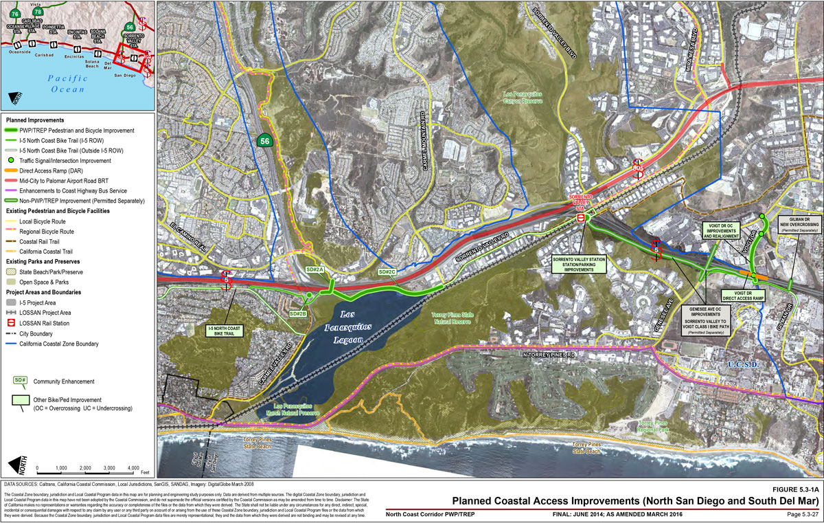
The San Diego segment (Figure 5.3-1A) would connect the University of California, San Diego (UCSD) to the cities of Del Mar and Solana Beach, providing access to COASTER's Sorrento Valley Station, and Los Peñasquitos and San Dieguito Lagoons. This enhancement would connect to multiple regional and local bicycle and pedestrian routes, including the Coastal Rail Trail, the California Coastal Trail, and the Sea-to-Sea Trail.
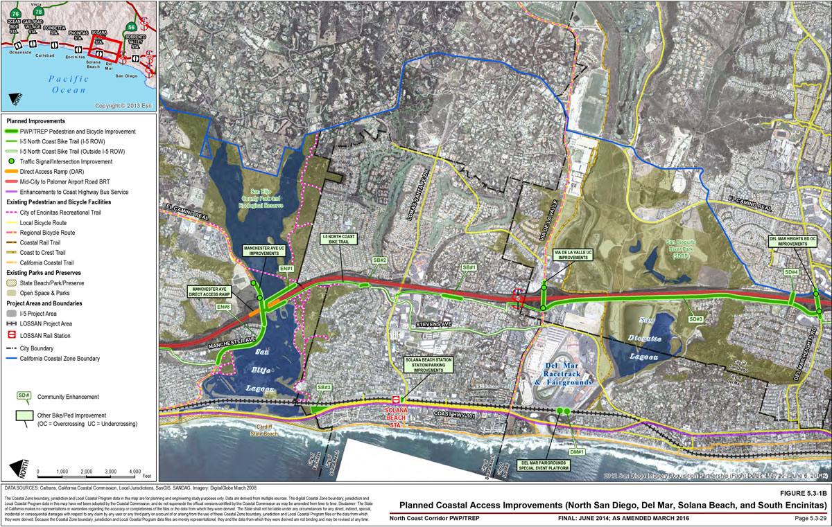
The Solana Beach segment (Figure 5.3-1B) would connect riders to San Diego, Del Mar, and Encinitas. The planned route would share city streets for the majority of its Solana Beach alignment, providing access to several adjacent schools and other activity centers. It would also connect to existing bicycle facilities on Via de la Valle and Lomas Santa Fe Drive, which provide access to and along coastal recreational resources as well as COASTER and Amtrak's Solana Beach Station.
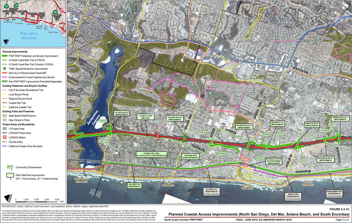
The Encinitas segment (Figures 5.3-1B and 5.3-1C) would connect riders to Solana Beach and Carlsbad. The planned route would share city streets for much of its Encinitas alignment but would utilize several separated trails and over-crossings (Community Enhancement projects EN#1, EN#4, EN#5B, and EN#6A below). The route would connect to existing local bicycle facilities on Santa Fe Drive and Leucadia Boulevard, as well as regional bicycle facilities at Manchester Avenue and Encinitas Boulevard. At Encinitas Boulevard, it would also provide access to rail services at nearby COASTER's Encinitas Station.
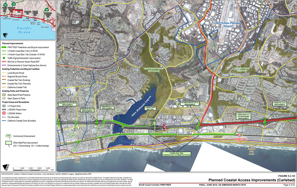
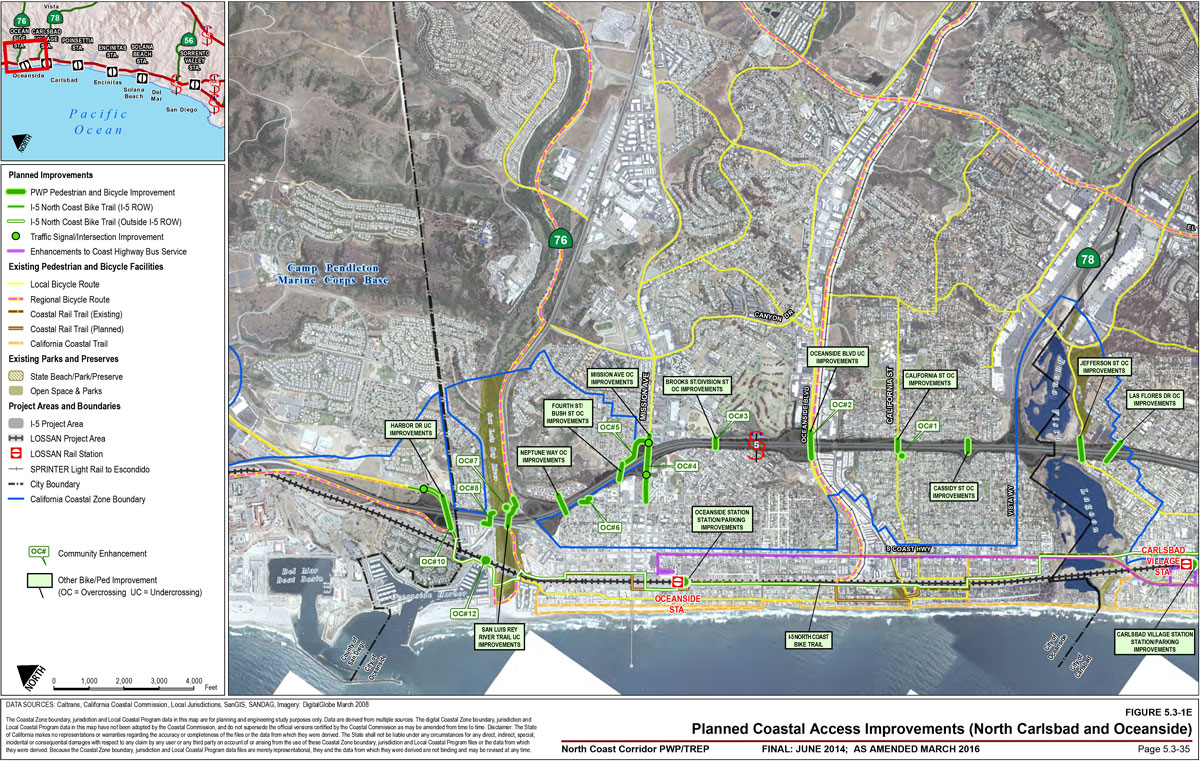
The Carlsbad segment (Figures 5.3-1C through 5.3-1E) would connect riders to Encinitas and Oceanside. The planned route would utilize city streets for some of its Carlsbad alignment– including sharing Class II facilities with the existing Coastal Rail Trail segments along Avenida Encinas and State Street–but would have its own Class I facility in many locations, including both lagoon crossings. It would connect to existing local bicycle facilities on La Costa Avenue, Poinsettia Lane, Cannon Road, and Tamarack Avenue, as well as regional bicycle facilities at Palomar Airport Road and the parallel Coastal Rail Trail. It would also provide adjacent access to COASTER's Carlsbad Poinsettia and Carlsbad Village Stations.
The Oceanside segment (Figure 5.3-1E) would connect Carlsbad to Camp Pendleton and the regional bicycle routes extending north to Orange County. The planned route would feature a mix of Class I, II, and III facilities, and would connect to two east-west regional bicycle routes: the Oceanside-Escondido Inland Rail Trail (at Oceanside Boulevard) and the San Luis Rey River Trail (adjacent to SR 76). By sharing the majority of its Oceanside alignment with the Coastal Rail Trail, the I-5 North Coast Bike Trail would be located closer to the LOSSAN rail corridor than the highway in Oceanside, providing convenient bicycle and pedestrian access to Oceanside Station (COASTER, SPRINTER, Metrolink, and Amtrak), the SPRINTER's Coast Highway Station, and numerous coastal resources.
Planned Improvements: LOSSAN Crossings
Along the LOSSAN rail corridor, the PWP/TREP includes new grade separations that would improve public access to coastal and inland recreation areas for automobiles, pedestrians, and bicycles at major intersections. Grade separations would reduce conflicts between pedestrians, bicycles, and motor vehicles along the rail corridor, which would increase coastal access opportunities as well as the safety of several modes of travel without impairing the speed or the unique travel experience available along the coastal rail corridor. Where possible, these improvements will be constructed concurrently with adjacent track projects to minimize construction impacts. The planned crossing improvements exclusively for bicycles and pedestrians are:
Coast to Crest Trail Crossing (Del Mar): Construct a pedestrian crossing of the LOSSAN rail corridor at the western end of the Coast to Crest Trail, a 55-mile east-west recreational corridor connecting Del Mar with Volcan Mountain near Julian. The partially completed trail is a major feature of the San Dieguito River Park, but it has several gaps, including the lack of a facility for hikers to cross the LOSSAN rail corridor to reach the coast. As part of the PWP/TREP program of improvements, this essential link would be completed, enhancing safety as well as facilitating coastal access between upland recreation areas and the shoreline. This project is also designated as Community Enhancement DM#1 and is included in the list of Community Enhancements later in the section. It does not yet have funding identified.
San Elijo Lagoon Gateway Pedestrian Under-crossing (Solana Beach): Construct a new grade-separated crossing of the LOSSAN rail corridor at San Elijo Lagoon, in the general proximity of Milepost 241. This would allow users of the existing San Elijo Lagoon trails to cross under the railroad tracks, creating new access to both the shoreline and the Gateway Open Space Preservation Site. This project is part of Community Enhancement SB#3 and is included in the list of Community Enhancements later in this section.
Hillcrest Drive Pedestrian Under-crossing (Encinitas): Construct a new grade-separated crossing of the LOSSAN corridor at Hillcrest Drive in Encinitas; unlike the planned grade separation at Leucadia Boulevard, this crossing would be for pedestrians and bicycles only. This project would provide a much-needed access route between residential areas and the beach, as Hillcrest Drive is located in the middle of a 1.3-mile stretch of the rail corridor (between Leucadia Boulevard and La Costa Avenue) that contains no crossings. It would connect to the Coast Highway local bicycle and pedestrian routes, the California Coastal Trail, and the planned Coastal Rail Trail segments between Chesterfield Drive and La Costa Avenue. This project would be part of a package of four grade-separated pedestrian crossings being constructed in Encinitas along the LOSSAN corridor, with the other three permitted prior to the PWP/TREP.
Chestnut Avenue LOSSAN Crossing (Carlsbad): Construct a new grade-separated crossing of the LOSSAN rail corridor at Chestnut Avenue in Carlsbad. Similar to the Hillcrest Drive crossing in Encinitas, this crossing would provide a new access route from the residential areas and parks east of the LOSSAN rail corridor to the beach. It would connect to the Coastal Rail Trail (both existing and planned segments), the bicycle and pedestrian routes on Coast Highway, and the California Coastal Trail. This project is also designated as Community Enhancement CB#6 and is included in the list of Community Enhancements later in the section. It does not yet have funding identified.
Harbor Drive LOSSAN Crossing Bicycle/Pedestrian Improvements (Oceanside): Improve the existing under-crossing of the LOSSAN rail corridor located north of the San Luis Rey River at the west end of the Harbor Drive parking lot. This project would provide bicycle and pedestrian access to coastal resources via an under-crossing that currently accommodates automobiles only. In conjunction with the proposed pedestrian improvements under I-5 north of the San Luis Rey River (Community Enhancement OC#8, described below), this project would provide a connection between the residential areas east of I-5 and the coast. This project is also designated as Community Enhancement OC#12 and is included in the list of Community Enhancements later in the section. It does not yet have full funding identified; however, the City of Oceanside has indicated its intent to use a portion of its annual TransNet allocation to partner and match funds on this project.
In addition to these exclusive crossings for bicycles and pedestrians, three additional grade-separated crossings of the LOSSAN rail corridor are planned at local roadways that will include bicycle and pedestrian improvements:
Leucadia Boulevard Grade Separation (Encinitas): Construct a new grade-separated crossing of the LOSSAN rail corridor at Leucadia Boulevard in Encinitas, to be used by bicycles and pedestrians as well as motorized traffic. This crossing would facilitate safer access to coastal resources, including Leucadia State Beach, for the residential neighborhoods east of the rail corridor; the current crossing is at-grade and contains incomplete sidewalks and no bicycle facilities. In addition, it would provide the first grade-separated crossing in the 2.7-mile stretch of track between Encinitas Station and La Costa Avenue. The new crossing would connect to the Class II bicycle lanes on Leucadia Boulevard, the Coast Highway local bicycle and pedestrian routes, the California Coastal Trail, and the planned Coastal Rail Trail segments between Chesterfield Drive and La Costa Avenue.
Two Additional Roadway Grade Separations: Two additional grade separations between surface streets and the LOSSAN rail corridor are planned in the SANDAG 2050 RTP. The locations of these grade separations have yet to be determined. (As discussed in Chapter 6A, additional project review would be required once more project details become available.)
Planned Improvements: I-5 Local Road and Trail Crossings
Beneficial impacts on coastal access and recreation would also result from highway improvements. Local roads cross I-5 at 32 locations within the NCC, in addition to the San Luis Rey River Trail crossing in Oceanside. Many of these crossings have substandard or incomplete bicycle and pedestrian facilities that inhibit safe crossing of the freeway by non-motorized modes. As over-crossings are rebuilt and under-crossings are widened to accommodate additional lanes on I-5, pedestrian and bicycle facilities will be upgraded. These improvements would address travel-user separations to provide a safer and more comfortable travel environment for pedestrians and bicyclists. Additionally, the majority of the sweeping, "free right" turns for autos that currently exist at I-5 on-ramps will be eliminated and replaced by 90-degree turns with safety signals for bicycles and pedestrians.
These improvements would further encourage the use of bicycle and pedestrian modes between inland and coastal areas, and in many instances, would provide connections to regional corridors and Class I and Class II bicycle facilities.16 Table 5.3-1A and 5.3-1Bsummarizes the planned improvements at I-5 crossings. Specific details on the scope of each crossing project can be found in Chapter 4.
Table 5.3-1A: Pedestrian Improvements Across I-5
Facility Type
Existing Facilities
Future Facilities
No sidewalk
3
0
6-foot sidewalk or smaller
29
4
7- to 9-foot sidewalk
0
1
10-foot sidewalk or larger
1
27
Table 5.3-1: Bicycle Improvements Across I-5
Facility Type
Existing Facilities
Future Facilities
Class III/Shared Use
24
9
Class II
7
21
Class I
2
2
For bicyclists, new Class II lanes are planned for the following highway crossings (projects marked with asterisks [*] are coordinated with adjacent community enhancement projects):
Voigt Drive Over-crossing (San Diego)
Via De La Valle Under-crossing (San Diego)
Manchester Avenue Under-crossing (Encinitas) (part of San Elijo Lagoon bridge replacement)
In addition, pedestrian improvements are planned for the following highway crossings (projects marked with asterisks [*] are coordinated with adjacent community enhancement projects):
Voigt Drive Over-crossing (San Diego)
Del Mar Heights Road Over-crossing (San Diego)
Via De La Valle Under-crossing (San Diego)
Manchester Avenue Under-crossing (Encinitas) (part of San Elijo Lagoon bridge replacement)
Birmingham Drive Over-crossing (Encinitas)
MacKinnon Avenue Over-crossing (Encinitas)*
Santa Fe Drive Under-crossing (Encinitas)
Requeza Street Over-crossing (Encinitas)*
Leucadia Boulevard Over-crossing (Encinitas)
La Costa Avenue Over-crossing (Carlsbad)*
Poinsettia Lane Over-crossing (Carlsbad)
Palomar Airport Road Over-crossing (Carlsbad)
Chinquapin Avenue Over-crossing (Carlsbad)
Tamarack Avenue Over-crossing (Carlsbad)
Chestnut Avenue Under-crossing (Carlsbad)
Carlsbad Village Drive Under-crossing (Carlsbad)
Las Flores Drive Over-crossing (Carlsbad)
Jefferson Street Over-crossing (Carlsbad)
Cassidy Street Over-crossing (Oceanside)
California Street Over-crossing (Oceanside)*
Brooks/Division Street Over-crossing (Oceanside)*
Mission Avenue Over-crossing (Oceanside)*
Fourth Street/Bush Street Over-crossing (Oceanside)*
In addition to the North Coast Bike Trail, Coastal Rail Trail, and corridor crossing improvements, the PWP/TREP also includes community enhancement project concepts that, if implemented, would substantially benefit the corridor's pedestrian, bicycle, and recreational uses. The proposed community enhancement projects were identified and developed in close collaboration with affected communities through coordinating project-development team meetings, developing preliminary design concepts, meeting with city officials and community stakeholders, and hosting community workshops. Pursuant to a cooperative agreement between Caltrans and the affected cities, Caltrans and SANDAG would construct the community enhancement projects throughout the NCC as part of highway and rail construction, and maintenance agreements would be organized with each city that allows future maintenance to become the responsibility of the local jurisdiction.
Generally, community enhancement projects consist of developing and/or enhancing pedestrian and bicycle facilities, community parks and open space buffers, interpretive facilities at lagoons, wetland restoration, enhanced view corridors, and improved scenic vista points within the six affected cities. These improvements would substantially enhance recreational opportunities in the corridor, while improving travel choices, by creating and completing linkages between communities, inland, and coastal areas, and access opportunities to the corridor's regionally significant natural resource and recreation areas.
In addition, parcels that are purchased for highway widening (but not required for use as permanent state right-of-way) could be considered for community pocket parks or public open space at the request of the local jurisdictions. The package of community enhancement projects included in the PWP/TREP, which were selected through a collaborative effort between Caltrans and the corridor cities, includes several such sites. The PWP/TREP also includes a Resource Enhancement and Mitigation Program, discussed in more detail in Sections 5.4 and 5.5 and Chapter 6B, which involves acquisition and habitat creation and enhancement of properties in the corridor that would be maintained as natural open space areas, thereby enhancing resources that would be accessible from travelers in the corridor and from surrounding areas.
As described in Implementation Measure 5.3.3 (Section 5.3.3.4), additional community enhancement projects may be incorporated into the PWP/TREP, if requested by the local government and in consultation with Caltrans/SANDAG, the Coastal Commission, and other affected agencies and stakeholders. Proposed projects must meet the four criteria listed in Implementation Measure 5.3.3, and initial projects may not have funding identified. With a fixed amount of highway-related funds available for community enhancements, one of the most important parts of the collaborative process between Caltrans, SANDAG, and the corridor cities has been the prioritization of projects. While the vast majority of community enhancements projects do fall within funding limits, the unconstrained list of projects exceeds currently available resources. As future funding sources are identified, these unfunded projects–which currently include projects DM#1 and OC#12, listed below–will be ready to advance.
Community Enhancements: City of San Diego (Figure 5.3-1A and Figure 5.3-1B)
SD#2A Carmel Valley Bicycle/Pedestrian Enhanced Trail Connection: Construct a Class I under-crossing just south of Carmel Valley Road, connecting Old Sorrento Valley Road (project SD#2C) to the existing SR 56 bicycle path. This would provide access to Los Peñasquitos Lagoon, the nearby coast, and the proposed Carmel Valley Park-and-Ride trailhead (project SD#2B). It would also allow bicyclists to cross the highway in a Class I facility, without having to ride on either Carmel Valley Road or El Camino Real. Finally, the enhancement would create links between several regional and local trail systems, including the Coastal Rail Trail, the Sea-to-Sea Trail (connecting the Salton Sea to the Pacific Ocean), and the existing local bicycle routes along El Camino Real and Carmel Valley Road).
SD#2B Enhanced Park-and-Ride at Carmel Valley Road: Improve the existing park-and-ride facility on the west side of I-5 to include an improved trailhead, pedestrian amenities, enhanced landscaping including a native plant visual buffer between the trail and parking areas, and a scenic overlook at Los Peñasquitos Lagoon. This would connect to the proposed highway under-crossing (project SD#2A) as well as the proposed Old Sorrento Valley Road trail improvements (project
SD#2C), which would be a shared facility for both the Coastal Rail Trail and I-5 North Coast Bike
Trail.
SD#2C Old Sorrento Valley Road Bicycle/Pedestrian Enhanced Trail Connections from Carmel Valley Road to Carmel Mountain Road: Construct a Class I bicycle and pedestrian facility from Carmel Valley Road/SR 56 to Carmel Mountain Road parallel to I-5, to include interpretive overlooks and trail information stations. In conjunction with projects SD#2A and SD#2B, this enhancement would provide improved connections to existing bicycle and trail systems that lead to both coastal and upland recreation areas and activity centers. Both the Coastal Rail Trail and the I-5 North Coast Bike Trail would share the facility, providing corridor-length mobility for bicycles and pedestrians.
SD#3 Bicycle/Pedestrian Enhanced Trail and Bridge on the West Side of I-5 at San Dieguito Lagoon: Construct a new Class I bicycle and pedestrian facility adjacent to the highway over San Dieguito Lagoon, in conjunction with the highway bridge construction. This would provide a new route for bicycles and pedestrians through San Dieguito Lagoon as well as new connectivity between northern San Diego and the cities of Solana Beach and Del Mar. The I-5 North Coast Bike Trail would share the facility, providing corridor-length mobility for bicycles and pedestrians.
SD#4 Pedestrian Overpass Connection North of Del Mar Heights Road: Construct a new bicycle and pedestrian bridge over I-5 north of Del Mar Heights Road. The bridge would link two adjacent but divided neighborhoods and provide improved access routes to two schools as well as coastal and recreational resources. It would also connect to the proposed I-5 North Coast Bike Trail, providing corridor-length mobility for bicycles and pedestrians.
Community Enhancement: City of Del Mar (Figure 5.3-1B)
DM#1 Coast to Crest Trail LOSSAN Crossing: Construct a pedestrian crossing of the LOSSAN rail corridor at the western end of the Coast to Crest Trail, a 55-mile east-west recreational corridor connecting Del Mar with Volcan Mountain near Julian. As described previously, the partially completed trail is a major feature of the San Dieguito River Park, but it has several gaps, including the lack of a facility for hikers to cross the LOSSAN rail corridor to reach the coast. As part of the PWP/TREP program of improvements–possibly in conjunction with the adjacent San Dieguito Double Track and Platform project (Section 4.1.1)–this essential link would be completed, enhancing safety as well as facilitating coastal access between upland recreation areas and the shoreline. This project does not currently have identified funding.
Community Enhancements: City of Solana Beach (Figure 5.3-1B)
SB#1 Streetscape Enhancements on Ida Avenue: Construct streetscape enhancements including sidewalks, curbs, and landscaping along Ida Avenue from Academy Drive to the south of Genevieve Street. This would provide for safer pedestrian and bicycle circulation in the surrounding community of Eden Gardens. The improvements would be consistent with the Eden Gardens Master Plan and Master Streetscape Plan, thus preserving the unique character of the historic neighborhood.
SB#2 Pedestrian Amenities at Solana Hills Drive: Construct improvements along the northern end of Solana Hills Drive, including improved signs and interpretive displays, near the trailhead at the south entrance to San Elijo Lagoon Ecological Reserve. This would provide improved amenities to users of the San Elijo Lagoon recreational facilities for bicycles and pedestrians. The I-5 North Coast Bike Trail would also share this facility, providing corridor-length mobility for bicycles and pedestrians.
SB#3 Gateway Open Space Preservation Site and Pedestrian Under-crossing: Contribute to the purchase of the Gateway Open Space Preservation Site by the San Elijo Lagoon Conservancy and construct a new grade-separated crossing of the LOSSAN rail corridor near Milepost 241. The 3.2-acre Gateway site, immediately adjacent to San Elijo Lagoon and Cardiff State Beach, will be preserved as open space. The new grade separation will allow users of the existing San Elijo Lagoon trails to cross under the railroad tracks, creating new access to both the Gateway site and the shoreline.
Community Enhancements: City of Encinitas (Figure 5.3-1B and Figure 5.3-1C)
EN#1 Bicycle/Pedestrian Enhanced Trail on Both Sides of I-5 at San Elijo Lagoon With Bridge Connection to Manchester Avenue: Construct new trails and associated sidewalks along the south side of Manchester Avenue, across San Elijo Lagoon under the I-5 bridge structure, and on the south side of the lagoon adjacent to the planned bridge replacement. This would provide important linkages between several heavily used trail segments that exist around the lagoon, which are discontinuous due to the barriers presented by both the lagoon and the highway. The I-5 North Coast Bike Trail would share this facility at the lagoon crossing, providing corridor-length mobility for bicycles and pedestrians. The planned improvements, which are consistent with the city's general plan, would create a unified and effective trail system around this important natural resource. The improvement would also provide connections to the existing Class II bicycle lanes on Manchester Avenue that extend in both directions, providing further links to the Coastal Rail Trail, Cardiff State Beach, LOSSAN rail services, and many inland activity centers.
EN#2A Park & Ride Enhancements at Birmingham Drive: Improve the existing park-and-ride facility to include new parking spaces and a trailhead for the proposed trail along Villa Cardiff Drive (project EN#2B). This would provide new bicycle and pedestrian access routes to the park-and-ride facility, promoting non-motorized travel in the corridor. It would also connect to the I-5 North Coast Bike Trail via the Villa Cardiff Drive trail.
EN#2B Villa Cardiff Drive and MacKinnon Bridge Enhancements: Construct new sidewalks, trails, and landscaping along Villa Cardiff Drive and the rebuilt MacKinnon Avenue over-crossing. This would connect the residential areas east of I-5 to the Hall Property Park on the west side the highway, as well as provide a bicycle and pedestrian link to the proposed park-and-ride facility at Birmingham Drive (project EN#2A). It would also connect to the I-5 North Coast Bike Trail, which would share the MacKinnon Avenue over-crossing and provide corridor-length mobility for bicycles and pedestrians.
EN#3 Hall Property Park Trail Connecting to Santa Fe Drive: Construct a new trail on the west side of I-5 from Santa Fe Drive to the Hall Property Park. This would provide bicycle and pedestrian access to the park from Santa Fe Drive, connecting to the existing Class II bicycle lanes that extend west from the highway to the coast. These existing lanes provide access to the Coastal Rail Trail, the California Coastal Trail, and rail services at Encinitas Station. This project would also connect to the I-5 North Coast Bike Trail via the improved under-crossing at Santa Fe Drive, providing corridor-length mobility for bicycles and pedestrians.
EN#4 Trail Connecting Santa Fe Drive to Requeza Street with Wetland Revegetation: Construct a trail connecting Santa Fe Drive to Requeza Street, including improved drainage and wetland vegetation restoration. In conjunction with the Hall Property Park Trail (project EN#3), the improved under-crossing at Santa Fe Drive, and the proposed trail leading from Requeza Street north to Encinitas Boulevard (project EN#5B), this project would provide a continuous bicycle and pedestrian facility between Encinitas Boulevard and the new Hall Property Park. The I-5 North Coast Bike Trail would also share the facility, providing corridor-length mobility for bicycles and pedestrians.
EN#5A Encinitas Boulevard Bicycle/Pedestrian Enhancements: Construct new 10-foot sidewalks on both sides of the Encinitas Boulevard under-crossing and maintain the existing Class II bicycle lanes. This project would improve pedestrian access across the highway, providing safer connections between the proposed trails on the east side of the I-5 (projects EN#4 and EN#5B), the I-5 North Coast Bike Trail, Cottonwood Creek Park, COASTER's Encinitas Station, and coastal resources including Moonlight State Beach. This segment of Encinitas Boulevard also constitutes the western end of the Encinitas-San Marcos Regional Bicycle Corridor, which continues inland approximately 13 miles to the City of San Marcos.
EN#5B Trail Connecting Requeza Street to Encinitas Boulevard: Construct a new trail along the east side of I-5 connecting Requeza Street with Encinitas Boulevard. In conjunction with the Hall Property Park Trail (project EN#3), the rebuilt over-crossing at Santa Fe Drive, and the proposed trail leading from Santa Fe Drive north to Requeza Street (project EN#4), this project would provide a continuous bicycle and pedestrian facility between Encinitas Boulevard and the new Hall Property Park. The I-5 North Coast Bike Trail would also share the facility, providing corridor-length mobility for bicycles and pedestrians. Finally, this project would connect to the existing Class II bicycle lanes on Encinitas Boulevard, which comprise the western end of the 13mile Encinitas-San Marcos Regional Bicycle Corridor.
EN#6A Union Street Pedestrian Overpass: Construct a new pedestrian and bicycle crossing over I-5, along with a new park on the west side of the bridge in a parcel owned by the City of Encinitas. The I-5 North Coast Bike Trail would share the facility, providing corridor-length mobility for bicycles and pedestrians. At its western end, this project would connect to the proposed recreational trail leading to Cottonwood Creek Park (project EN#6B), which would then connect to an existing local trail leading to Encinitas Boulevard; this would provide a new bicycle and pedestrian route across the highway to Encinitas Station, the Coastal Rail Trail, the Encinitas-San Marcos Regional Bicycle Corridor, and coastal resources including Moonlight State Beach.
EN#6B Cottonwood Creek Park to Union Street Trail Connection with Wetland Revegetation: Construct a new trail connecting Cottonwood Creek Park to Union Street on the west side of I-5. This project would connect the proposed new over-crossing at Union Street (project EN#6A) to the existing City of Encinitas recreational trail leading to Encinitas Boulevard, creating a new bicycle and pedestrian route across the highway to Encinitas Station, several regional bicycle and pedestrian routes, and coastal resources. On the northern end, the project would also connect to the I-5 North Coast Bike Trail at Union Street, which would provide corridor-length mobility for bicycles and pedestrians.
EN#8 Manchester Avenue Trail to Nature Center: Construct a new traffic-separated path/trail along Manchester Avenue connecting the San Elijo Multi-Use Facility to the San Elijo Lagoon Nature Center. A portion of the alignment along Manchester Avenue would be shared with the I-5 North Coast Bike Trail. However, this proposed trail connection would be an enhancement above and beyond the sidewalk improvements and Class III bike route originally proposed for Manchester Avenue. With the full approval of the proposed Manchester Avenue interchange improvements (including the Manchester DAR, San Elijo Multi-Use Facility and associated signalized intersections), this Community Enhancement would be constructed, thereby enabling safer pedestrian crossings under the highway bridge and improved east-west connectivity to the existing trail system. The trail connection could also be pursued as a "below the line" Community Enhancement project if funding were to become available.
Community Enhancements: City of Carlsbad (Figure 5.3-1C, Figure 5.3-1D, and Figure 5.3-1E)
CB#1A Bicycle/Pedestrian Enhanced Trail and Bridge on West Side of Batiquitos Lagoon: Construct a trail along the west side of I-5 from La Costa Avenue to Avenida Encinas, crossing Batiquitos Lagoon as a suspended facility under the I-5 bridge structure (similar to projects EN#1 and CB#3). This would provide a new route for bicycles and pedestrians to cross the lagoon, and in conjunction with the proposed connection to the lagoon's eastern trails (project CB#2), would create a full loop for pedestrians around the lagoon. The I-5 North Coast Bike Trail would share the facility, providing corridor-length mobility for bicycles and pedestrians. At its southern end, the project would also connect to the existing Class II bicycle facility at La Costa Avenue. At the northern end, it would merge with the Class II facilities of the Coastal Rail Trail along Avenida Encinas, which feature direct routes to COASTER's Poinsettia Station as well as South Carlsbad State Beach.
CB#1B Park-and-Ride Enhancement at La Costa Avenue: Improve the existing park-and-ride facility to include new parking spaces and landscaping. By connecting to the existing Class II bicycle route at La Costa Avenue as well as the proposed Batiquitos Lagoon crossing (project CB#1A) and I-5 North Coast Bike Trail, this project would provide improved bicycle and pedestrian access to the park-and-ride facility, promoting non-motorized travel in the corridor.
CB#2 Trail on Northeast Side of I-5 at Batiquitos Lagoon: Construct a trail connection between the proposed lagoon crossing (project CB#1A) and the existing trail on the east side of I-5. In conjunction with the proposed lagoon crossing, this project would complete a full loop for pedestrians around Batiquitos Lagoon. It would also connect to the previously approved Rosalena Trail, to be located along the northwest perimeter of the lagoon atop the lagoon bluffs. Finally, the planned trail would also connect to the I-5 North Coast Bike Trail, providing corridor-length mobility for bicycles and pedestrians.
CB#3 Bicycle/Pedestrian Enhanced Trail and Bridge on East Side of I-5 at Agua Hedionda Lagoon: Construct a trail along the east side of I-5 crossing Agua Hedionda Lagoon as a suspended facility under the I-5 bridge structure (similar to projects EN#1 and CB#1A). The project would also include an east-west crossing under the highway, connecting to existing lagoon trails and the planned Coastal Rail Trail segment from Cannon Road to Tamarack Avenue (described previously). The I-5 North Coast Bike Trail would share the facility, providing corridor-length mobility for bicycles and pedestrians.
CB#5 Chestnut Avenue I-5 Crossing Bicycle/Pedestrian Improvements: Construct new Class
II bicycle lanes and widen sidewalks in both directions. Currently, there are no bicycle lanes and only narrow sidewalks at this under-crossing, which is heavily used by local residents to reach Holiday Park, immediately east of the highway. The improvements would provide continuity with the existing Class II bike lanes that proceed east on Chestnut Avenue, as well as the adjacent Class II lanes located to the west of the interchange on Harding Street.
CB#6 Chestnut Avenue LOSSAN Crossing: Construct a new grade-separated crossing of the LOSSAN rail corridor for bicycles and pedestrians at Chestnut Avenue in Carlsbad. As described previously, this crossing would provide a new access route from the residential areas and parks east of the LOSSAN rail corridor to the beach. It would connect to the Coastal Rail Trail (both existing and planned segments), the bicycle and pedestrian routes on Coast Highway, and the California Coastal Trail. This project does not currently have identified funding.
Community Enhancements: City of Oceanside (Figure 5.3-1E)
OC#1 Pocket Park and Pedestrian Path at California Street: Construct new Class II bicycle lanes and 17-foot sidewalks at the replaced California Street over-crossing, to include landscaping elements and a pocket park at Moreno Way. The project would also enhance pedestrian crossings at the intersection of California and Moreno Street, as well as the intersections of Soto Street with California and Valencia Streets. This project would provide a safer route for pedestrians and bicycles to cross the I-5, connecting several residential neighborhoods, schools, and activity centers on both sides of the highway. The Class II bicycle lanes would connect to existing Class III facilities on California Street in both directions, with the western route connecting to the Coastal Rail Trail and other coastal resources.
OC#2 Oceanside Boulevard Pedestrian Streetscape Enhancement: Construct widened sidewalks and landscaping at the Oceanside Boulevard under-crossing, as well as enhanced safety fencing at the adjacent SPRINTER rail right-of-way. Existing Class II bicycle lanes, which are part of the regional Oceanside-Escondido Inland Rail Trail, would be maintained. This project would provide improved pedestrian safety at the highway crossing, which is within 1 mile of two SPRINTER light rail stations–the Coastal Rail Trail and the California Coastal Trail–and several activity centers.
OC#3 Division Street Bicycle/Pedestrian Enhancements: Construct new 17-foot sidewalks on each side of the rebuilt over-crossing, as well as widened sidewalks on Brooks Street east of the highway. Existing Class III bicycle facilities would be maintained. This project would provide a safer connection between the residential neighborhood west of the highway–which includes Oceanside High School–to Ron Ortega Recreation Park and other significant activity centers to the east.
OC#4 Mission Avenue Bicycle/Pedestrian Enhancements: Construct new widened sidewalks and Class II bicycle lanes at the replaced over-crossing, including realignment of the highway on- and off-ramps to allow for signalized pedestrian crossings. This project would provide safer access for bicyclists and pedestrians crossing the highway to access downtown Oceanside, Oceanside High School, Oceanside Station (COASTER, SPRINTER, Metrolink, and Amtrak), and coastal resources. The new bicycle lanes would connect to the existing Class II bicycle lanes that extend east on Mission Avenue; to the west, the City of Oceanside is preparing to realign Mission Avenue to include enhanced bicycle and pedestrian facilities as well.
OC#5 Bush Street Bicycle/Pedestrian Enhancements and Community Gardens: Construct facilities to connect the existing community gardens at Civic Center Drive and North Weitzel Street (west of I-5) with new community garden plots to the east of I-5. The project would also construct a paved trail and linear park from the east side of the over-crossing to Buena Street, and construct wider sidewalks on Buena and Santa Barbara Streets. In conjunction with the Bush Street over-crossing replacement, this project would provide improved pedestrian and bicycle access across I-5, connecting existing and new community gardens as well as residential neighborhoods on both sides of the highway.
OC#6 Community Open Space Park and/or Community Gardens: Construct a 0.285-acre community open space park and/or community gardens adjacent to the Family Recovery Center on Horne Street. Park design would be determined through other processes and community input but could include meandering paths, water features, detailed native plantings, and public artwork. This project would provide a new recreational area for nearby residents as well as clients and staff of the Family Recovery Center.
OC#7 SR 76 Underpass: New Parking and Trailhead: Construct a new parking area and trailhead east of the highway at the SR 76 interchange, including the removal of an obsolete highway ramp. This project would improve bicycle and pedestrian access to the San Luis Rey River Trail, which is a regional Class I facility along the river, whose watershed the County of San Diego has proposed to designate as a 1,700-acre regional park. Just west of this site, the trail crosses under I-5 in a tunnel (which is also planned for improvement) and connects with the Coastal Rail Trail, I-5 North Coast Bike Trail, and regional bicycle routes leading north to Camp Pendleton and Orange County. To the east, the trail continues along the river for approximately 7 miles and then connects to other local bicycle and pedestrian facilities.
OC#8 Pedestrian Underpass Improvements North of San Luis Rey River: Improve the existing sidewalk under I-5 north of the San Luis Rey River to include new ramps, lighting, and landscaping. The existing crossing is isolated, poorly lighted, and not in compliance with Americans with Disabilities Act requirements. The planned improvements would provide pedestrians–particularly those living in the residential neighborhoods east of the highway–with a safer access route to cross the highway and reach coastal resources.
OC#10 Harbor Drive/Camp Pendleton Bicycle and Pedestrian Enhancements: Construct new Class II bicycle lanes and widen the existing eastbound sidewalk to 8 feet. This would provide safer means for bicycles and pedestrians to cross the highway, providing access to Oceanside Harbor, the San Luis Rey River Trail and the recreation area, and the regional bicycle route extends north to Camp Pendleton and Orange County. The I-5 North Coast Bike Trail also would share the facility, providing corridor-length mobility for bicycles and pedestrians.
OC#12 Harbor Drive LOSSAN Crossing Bicycle/Pedestrian Improvements: Improve the existing under-crossing of the LOSSAN rail corridor located north of the San Luis Rey River at the west end of the Harbor Drive parking lot. This project would provide bicycle and pedestrian access to coastal resources via an under-crossing that currently accommodates automobiles only. In conjunction with the proposed pedestrian improvements under I-5 north of the San Luis Rey River (project OC#8), this project would provide a connection between the residential areas east of I-5 and the coast. This project does not currently have identified funding; however, the City of Oceanside has indicated its intent to use a portion of its annual TransNet allocation to partner and match funds on this project.
Figure 5.3-1A - Planned Coastal Access Improvements (North San Diego and South Del Mar) Figure 5.3-1B - Planned Coastal Access Improvements (North San Diego, Del Mar, Solana Beach, and South Encinitas) Figure 5.3-1C - Planned Coastal Access Improvements (North San Diego, Del Mar, Solana Beach, and South Encinitas). Figure 5.3-1D - Planned Coastal Access Improvements (Carlsbad).
Figure 5.3-1E - Planned Coastal Access Improvements (North Carlsbad and Oceanside).
Coastal Access Improvements Permitted Separately from PWP/TREP
The regional commitment to improving coastal access in the NCC extends beyond the PWP/TREP, with many improvements being permitted separately. The following projects support the PWP/TREP goal of improving coastal and upland access and are already advancing through the stages of planning and delivery:
Genesee Avenue Over-crossing (San Diego): Construct new sidewalks and Class II bicycle lanes, providing connections to existing local bicycle routes and the Sorrento Valley to Voigt Class I Bike Path.
Sorrento Valley to Voigt Class I Bike Path (San Diego): Construct a new dedicated bicycle facility parallel to I-5, which would connect UCSD and Sorrento Valley Station, and eliminate the need for bicyclists to ride on the freeway shoulder. This project would share facilities with the I-5 North Coast Bike Trail.
Gilman Drive Over-crossing (San Diego): Construct a new over-crossing of I-5 at Gilman Drive, to include new auto and bicycle lanes, providing improved access between the two major sides of the campus of the University of California, San Diego.
Santa Fe Drive Pedestrian Under-crossing (Encinitas): Construct new pedestrian rail crossing, providing improved coastal access.
El Portal Street Pedestrian Under-crossing (Encinitas): Construct new pedestrian rail crossing, providing improved coastal access.
Additionally, SANDAG and corridor cities are pursuing the completion of several other Coastal Rail Trail projects (beyond those included in the PWP/TREP) as part of the SANDAG Regional Bicycle Plan EAP. Adopted in September 2013, the EAP allocates funding to numerous bicycle and pedestrian projects of regional significance, including segments of the Coastal Rail Trail in the NCC that are unfinished or need additional improvements. Taken together, the PWP/TREP and EAP projects will nearly complete the Coastal Rail Trail throughout the NCC and the region. Notable NCC Coastal Rail Trail projects in the EAP include the following:
Del Mar to Sorrento via Carmel Valley (San Diego): Improve the existing Coastal Rail Trail segment along Carmel Valley Road between the Del Mar city limit and I-5. This project will be adjacent to Community Enhancement SD#2C, which will also improve an existing Coastal Rail Trail segment.
Coastal Rail Trail Del Mar (Del Mar): Improve the existing Coastal Rail Trail alignment through Del Mar to include improved striping and bike infrastructure.
Chesterfield Avenue to Solana Beach (Encinitas): Improve the existing Coastal Rail Trail alignment in Encinitas from Chesterfield Avenue to the Solana Beach city limit, including the crossing of San Elijo Lagoon via Coast Highway. Improvements may include improved striping and bike infrastructure.
Palomar Airport Road to Cannon Road (Carlsbad): Construct the planned Coastal Rail Trail segment between Palomar Airport Road and Cannon Road in Carlsbad to include the small segment outside the LOSSAN rail right-of-way that is not included in the PWP/TREP.
Oak Avenue to City Limit (Carlsbad): Construct the planned Coastal Rail Trail segment in Carlsbad between Oak Avenue and the Oceanside city limit to include the crossing of Buena Vista Lagoon via Coast Highway.
Oceanside Boulevard to Wisconsin Avenue (Oceanside): Construct the planned Coastal Rail Trail segment in Oceanside between Oceanside Boulevard and Wisconsin Avenue.
Loma Alta Marsh Bridge (Oceanside): Construct a bridge crossing for the Coastal Rail Trail over Loma Alta Marsh in Oceanside.
5.3.3.2 PWP/TREP Policies
Caltrans and SANDAG would implement the following policy to ensure that proposed improvements are designed, implemented, and maintained to provide for maximum protection of public access to and along recreational resources.
Policy 5.3.1:
Maximum public access to and along coastal and inland recreational resources in the PWP/TREP planning area shall be protected and enhanced, consistent with public safety and sensitive coastal resource needs.
5.3.3.3 PWP/TREP Design/Development Strategies
The following design and development strategies provide guidance for siting and designing specific PWP/TREP rail projects, and Caltrans/SANDAG shall utilize the following design and development strategies for all projects subject to NOID procedures, consistent with the public access and recreation policies of PWP/TREP Policy 5.3.1, amended local coastal programs (LCPs), and the Coastal Act:
Project-level analysis for potential coastal access and recreation impacts of infrastructure improvements shall confirm that proposed improvements will minimize, to the maximum extent feasible, substantial impacts to coastal access and recreation resources. Should project-level analysis find that previously unidentified permanent or temporary impacts to coastal access and recreational resources will result from proposed improvements, additional study of feasible avoidance and mitigation measures to ensure project consistency with applicable Coastal Act public access and recreation policies shall be achieved during future, project-specific Federal Consistency review.
To ensure a balanced approach to multimodal transportation system improvements, PWP/TREP project implementation and phasing shall be carried-out consistent with phasing procedures and requirements provided in Chapter 6A - Implementation, and all relevant procedures.
Submittals for individual highway, rail station and pedestrian crossings, community, and resource enhancement projects located within or directly adjacent to an existing public coastal access or recreation area (trail or parkland) shall include a description of features included in the project and shall detail the type and location of mitigation elements included in the project, which avoid and/or minimize potential temporary construction impacts to coastal access and recreation. Submittals for community enhancement projects shall include a cooperative maintenance agreement with the affected city.
To the extent feasible, all new/improved rail and highway facility pedestrian crossings shall be designed and constructed in compliance with applicable state and federal standards, including the Americans with Disabilities Act, and in consultation with the relevant local and state stakeholders, in order to include available safety upgrades at affected pedestrian crossings.
Caltrans/SANDAG will conduct ongoing coordination with the affected local jurisdiction/s regarding project design for each specific development project. Public signage and educational materials will be provided for future public access and community enhancement projects, which will include public educational measures to ensure that users are aware of temporary impacts that may be present due to construction and to identify new public access components that are completed as a part of the PWP/TREP.
Additional community enhancement projects may be incorporated into the PWP/TREP, if requested by the local government and in consultation with Caltrans/SANDAG, Coastal Commission, stakeholders, and resource and regulatory agencies, as applicable, and assuming the project has been identified as meeting the following evaluation criteria:
The project is located within or adjacent to the LOSSAN rail and/or I-5 highway right-of-way.
The enhancement project will provide regionally significant community, public access and/ or coastal resource benefits.
e project will not result in significant environmental impacts beyond the impacts identified and evaluated in the LOSSAN Program EIR/EIS, the I-5 North Coast Corridor EIR/EIS, and/or the NCC PWP/TREP.
Funding is available to complete project planning, design, construction and maintenance of the enhancement.
Additional community enhancement projects may be incorporated into the PWP/TREP pursuant to:
the applicable NOID and/or PWP amendment procedures outlined in Chapter 6A of the PWP/TREP,
the coastal development permit review process, and/or 3) the federal consistency certification process.
5.3.3.4 Implementation Measures
Caltrans/SANDAG would utilize the following implementation measures for all projects subject to Notice of Impending Development (NOID) procedures:
Implementation Measure 5.3.1: NOID submittals for individual highway, rail station and pedestrian crossings, transit, and community enhancement projects should include a final construction schedule identifying dates for project construction which should be scheduled, to the maximum extent feasible, to avoid adverse effects on traffic flow on I-5 and local arterials by closure of no more than one lane in either direction of I-5 during peak travel hours.
Implementation Measure 5.3.2: NOID submittals for individual highway, rail station and pedestrian crossings, transit and community enhancement projects should include a Demolition, Staging, Storage, Fueling, and Debris/Excess Graded Material Disposal Plan which should include provisions and requirements designed to ensure that public access pedestrian and bicycle trails and/or public recreation areas are not adversely affected by these elements of project activities and that the footprint of disturbance associated with these activities is the minimum possible, in accordance with Caltrans' proposal. No fencing or other barriers except as specifically authorized pursuant to an approved NOID should be placed in a location that would limit public access to pedestrian or bicycle trails or other public recreation areas.
5.3.4 Coastal Act Consistency
The Coastal Act contains numerous policies that address the protection and enhancement of public access and recreation opportunities.
Coastal Act Section 30210
In carrying out the requirement of Section 4 of Article X of the California Constitution, maximum access, which shall be conspicuously posted, and recreational opportunities shall be provided for all the people consistent with public safety needs and the need to protect public rights, rights of private property owners, and natural resource areas from overuse.
Coastal Act Section 30211
The development shall not interfere with the public's right of access to the sea were acquired through use or legislative authorization, including, but not limited to, the use of dry sand and rocky coastal beaches to the first line of terrestrial vegetation.
Coastal Act Section 30212
30212(a) provides that in new shoreline development projects, access to the shoreline and along the coast shall be provided except in specified circumstances, where:
it is inconsistent with public safety, military security needs, or the protection of fragile coastal resources.
adequate access exists nearby, or,
agriculture would be adversely affected. Dedicated access shall not be required to be opened to public use until a public agency or private association agrees to accept responsibility for maintenance and liability of the accessway.
Coastal Act Section 30212.5
Wherever appropriate and feasible, public facilities, including parking areas or facilities, shall be distributed throughout an area so as to mitigate against the impacts, social and otherwise, of overcrowding or overuse by the public of any single area.
Coastal Act Section 30213
Lower cost visitor and recreational facilities shall be protected, encouraged, and, where feasible, provided. Developments providing public recreational opportunities are preferred.
Coastal Act Section 30214
The public access policies of this article shall be implemented in a manner that takes into account the need to regulate the time, place, and manner of public access depending on the facts and circumstances in each case including, but not limited to, the following:
Topographic and geologic site characteristics.
The capacity of the site to sustain use and at what level of intensity.
The appropriateness of limiting public access to the right to pass and repass depending on such factors as the fragility of the natural resources in the area and the proximity of the access area to adjacent residential uses.
The need to provide for the management of access areas so as to protect the privacy of adjacent property owners and to protect the aesthetic values of the area by providing for the collection of litter.
It is the intent of the Legislature that the public access policies of this article be carried out in a reasonable manner that considers the equities and that balances the rights of the individual property owner with the public's constitutional right of access pursuant to Section 4 of Article X of the California Constitution. Nothing in this section or any amendment thereto shall be construed as a limitation on the rights guaranteed to the public under Section 4 of Article X of the California Constitution.
In carrying out the public access policies of this article, the commission and any other responsible public agency shall consider and encourage the utilization of innovative access management techniques, including, but not limited to, agreements with private organizations that would minimize management costs and encourage the use of volunteer programs.
Coastal Act Section 30223
Upland areas necessary to support coastal recreational uses shall be reserved for such uses, where feasible.
Coastal Act Section 30252
The location and amount of new development should maintain and enhance public access to the coast by:
facilitating the provision or extension of transit service,
providing commercial facilities within or adjoining residential development or in other areas that will minimize the use of coastal access roads,
providing non-automobile circulation within the development,
providing adequate parking facilities or providing substitute means of serving the development with public transportation,
assuring the potential for public transit for high intensity uses such as high-rise office buildings, and by
assuring that the recreational needs of new residents will not overload nearby coastal recreation areas by correlating the amount of development with local park acquisition and development plans with the provision of onsite recreational facilities to serve the new development.
Coastal Act Section 30254
New or expanded public works facilities shall be designed and limited to accommodate needs generated by development or uses permitted consistent with the provisions of this division; provided, however, that it is the intent of the Legislature that State Highway Route 1 in rural areas of the coastal zone remains a scenic two-lane road. Special districts shall not be formed or expanded except where assessment for, and provision of, the service would not induce new development inconsistent with this division. Where existing or planned public works facilities can accommodate only a limited amount of new development, services to coastal-dependent land use, essential public services and basic industries vital to the economic health of the region, state, or nation, public recreation, commercial recreation, and visitor-serving land uses shall not be precluded by other development.
As planned and designed, the system of proposed PWP/TREP transportation improvements would result in inherent substantial benefits to coastal access and recreation. The proposed corridor design and development strategies ensure that coastal access and recreational resources would be considered in the planning and design for the corridor improvement projects so that maximum public access to and along coastal and inland recreational resources in the PWP/TREP corridor would be protected (and where feasible, enhanced), consistent with public safety and sensitive coastal resources needs. Implementation of the proposed improvements would significantly enhance public access to and along the coast and inland recreational resources; without the proposed project, coastal access is expected to continue to degrade because of projected population growth and constrained facilities, resulting in a substantial increase in congestion on the region's primary access corridor to the coast.
As the primary means for the public to reach shoreline access points and upland recreational destinations in the corridor, I-5 serves as the gateway to the entire San Diego coastal area and provides a unique scenic, recreational traveling experience. As travel demand in the I-5 highway corridor continues to increase, so does the existing coastal access impediment of traffic congestion. Proposed PWP/TREP improvements focusing on Express Lanes would give priority to ride-sharing and public transit (and when capacity allows, SOVs), while reducing overall congestion, protecting and facilitating public access, and funding transit investments. The proposed PWP/TREP program ensures that the corridor's large and varying customer base of HOVs (many of which are seeking access to and along coastal resources) would be provided with a reliable transportation corridor. In addition, rail improvements that increase capacity, reduce travel time, increase reliability, and provide new service area opportunities, such as those proposed, are readily recognized as major contributors to protecting and enhancing coastal access to and along the coast. Proposed PWP/TREP improvements would contribute substantially to enhancing multimodal access throughout the corridor by increasing rail service; providing new rail service at Del Mar Fairgrounds and Racetrack; accommodating better vehicle, pedestrian, and bicycle access to rail stations; and supplementing parking supply at, adjacent to, or in close proximity to rail stations to support access to and along nearby beaches and upland recreational areas.
Proposed improvements would include public transportation infrastructure to support more frequent, attractive, and reliable bus transit services (including BRT and enhanced local bus services), which would result in higher transit ridership and reduced traffic congestion that would otherwise adversely affect the ability of the public to reach the coast along this primary coastal access corridor. Proposed improvements would encourage non-automobile transportation with new and improved multimodal transportation improvements that would provide access to and along the coast and recreation areas via trails, bicycle paths, and transit. Improved bicycle and pedestrian facilities and routes would better connect with public transit centers, thereby promoting carpooling and compatibility rail and bus improvements. Such improvements would not only facilitate multimodal access to and along the coast but would also provide multimodal access to recreational and low-cost visitor-serving recreation areas for transit-dependent populations that may not otherwise have the means to access coastal areas.
Proposed grade separations along the LOSSAN rail corridor would provide new or improved, convenient pedestrian and bicycle crossings over the tracks, better connecting communities to area beaches. Proposed highway improvements would include reconstructing under- and overpasses, which would present an opportunity to connect and improve local and regional bicycle and pedestrian routes to and from the coast. Additionally, new and enhanced access routes across lagoons would be similarly integrated into proposed improvements. These PWP/TREP components would serve to meet one of the primary goals, as articulated in Completing the California Coastal Trail, which is to "Create linkages to other trail systems and to units of the State Park system, and use the Coastal Trail system to increase accessibility to coastal resources from urban population centers."17 PWP/TREP implementation would provide and connect several threads within the coastal trail system between inland and coastal communities access the shoreline, lagoons, and upland recreation, thus helping to achieve the goals of Completing the California Coastal Trail.
PWP/TREP development strategies and implementation measures would require that transportation system improvements be implemented in a balanced manner to ensure that the maximum benefit of the multimodal transportation improvements program is realized. PWP/TREP policies and implementation measures would ensure that maximum public access to and along coastal and inland recreational resources in the NCC be protected and enhanced consistent with public safety and sensitive coastal resources needs. PWP/TREP implementation measures would also address the design criteria of new pedestrian and bicycle amenities to ensure appropriate separation of vehicular, pedestrian and bicycle facilities to provide a more comfortable travel environment for pedestrians and bicyclists to further encourage these modes of travel across I-5 between inland and coastal areas.
PWP/TREP development strategies and implementation measures further require that project-level analysis for corridor improvements evaluate potential coastal access and recreation impacts and confirm that proposed improvements avoid substantial impacts to coastal access and recreation resources, or that additional study and mitigation measures be implemented if potential impacts are identified. In the event that additional study is required to address previously unidentified potential impacts, project consistency with applicable Coastal Act public access and recreation policies would be achieved during future, project-specific federal consistency or NOID review, where applicable.
PWP/TREP project implementation and phasing would be carried out consistent with phasing procedures and requirements provided in Chapter 6A - Implementation to further ensure a balanced approach to multimodal transportation system improvements. These phasing procedures and requirements would identify project phasing and implementation priorities for rail improvements, and provide the mechanism to track the progress of rail corridor project implementation in the context of all other PWP/TREP highway, community, and resource enhancement project implementation. The procedures also provide for maximum flexibility in implementing all PWP/TREP improvements to accommodate opportunities and uncertainties in potential future funding availability and local, state, and federal political and policy decisions, while ensuring that projects are implemented in a way that balances rail and highway improvements, and that community and resource enhancements are implemented prior to, or concurrent with, project implementation.
PWP/TREP development strategies and implementation measures would further address potential public access and recreation impacts associated with construction activities (including construction scheduling) to avoid impacts to access during the summer season and staging to minimize displacement of recreational areas and/or interference with access routes. This would also function to coordinate and minimize construction staging locations were possible among PWP/TREP projects.
As described in Sections 5.1 and 5.2, the proposed PWP/TREP includes improvements to public transportation facilities necessary to serve and support existing and future land uses previously approved by the Coastal Commission pursuant to certified LCPs and/or approved coastal development permits. The proposed transportation improvements would not result in excessive growth-inducing impacts that could result in overburdening the corridor's recreational resources. As such, PWP/TREP improvements would not be growth-inducing, nor would the proposed transportation improvements substantially increase vehicle miles traveled or exacerbate existing congestion problems on I-5.
Additionally, the proposed PWP/TREP improvements are not projected to result in substantial impacts to travel demand and traffic congestion on the NCC's local roads. While highway capacity improvements in other corridors sometimes can induce more travel on local roads, the majority of the NCC is projected to experience the opposite effect: demands for local roads would diminish in many places as a result of the improvements to I-5. As noted in Chapter 3A, the corridor's topographic constraints and circuitous street network make I-5 the most direct north-south route for many trips, but frequent congestion on the highway leads many travelers to attempt their trips on local roads instead. With additional capacity available on I-5, this "spillover traffic" in local communities would be reduced. Caltrans has conducted several evaluations of the I-5 project's impacts on local traffic, with the following results projected between the No-Build and Build scenarios:
Coast Highway and El Camino Real, the two primary north-south alternatives to I-5, were projected to experience reductions in vehicle miles traveled of 17% and 10%, respectively, between the 2030 No-Build and 2030 Build scenarios.18
Coast Highway and El Camino Real were projected to experience overall reductions in Average Daily Traffic (ADT) of 12% and 3%, respectively, between the 2035 No-Build and 2035 Build scenarios.19
In an analysis of 131 roadway segments–including key arterials and intersections selected jointly by Caltrans and corridor cities–the proposed highway improvements were shown to have negligible impacts on local traffic, with 68 of the 131 segments (52%) experiencing either decreases or no change in 2030 ADT between the No-Build and Build scenarios. An additional 51 segments (39%) were projected to experience ADT increases of less than 10%. Only 12 (9%) of the local NCC roadways would experience increases in ADT of over 10%.20
Even with increases in ADT on some roadways, only 3 segments (2%) that were under capacity in the 2030 No-Build scenario were projected to exceed capacity in the 2030 Build scenario. Eighty-five segments that were under capacity in the 2030 No-Build scenario remained under capacity in the 2030 Build scenario and five segments that were overcapacity in the 2030 No-Build scenario are projected to be under capacity in the 2030 Build scenario.21
A study of traffic level of service at 75 key intersections near freeway access points showed either improvement or no change at 73 intersections (97%) in the morning peak period and 68 intersections (91%) in the evening peak period when comparing the 2030 No-Build and 2030 Build scenarios.22
Taken together, these data indicate that the capacity improvements on I-5–by providing a better option for north-south travel than local roads–actually will help to relieve traffic congestion in the NCC's communities.
While the NCC provides unique and varying recreational opportunities, population growth and decades of private development in the region have diminished these opportunities. As the region's population has expanded and open lands, beaches, and historic trails have become developed, more people have sought the use of the corridor's coastal recreation resources. In addition, many critical support facilities for access and recreation have been affected as available transportation, transit, parking, and other amenities have become overburdened and have become difficult to accommodate or expand given the shrinking supply of land available to provide for such facilities. Thus, improving and maintaining overall mobility in the corridor is critical to removing existing transportation impediments to coastal access and meeting future demand for access to and along coastal and upland recreation opportunities. Moreover, coastal access is expected to continue to degrade because of projected population growth and constrained facilities. The PWP/TREP would prevent or reduce significant adverse impacts to coastal access compared to a No-Build Alternative. PWP/TREP improvements would provide a multimodal transportation system, providing reliable access to and from coastal-dependent industry and coastal and upland areas in the corridor and entire San Diego region, and would thereby affirmatively implement Coastal Act policies that require maximum protection and, where feasible, enhancement of coastal access and recreation. Finally, as discussed in Sections 5.4 and 5.5, the PWP/TREP includes improvements and a Resource Enhancement and Mitigation Program (detailed in Chapter 6B) to address water quality, lagoon, and natural habitat deficiencies. These project elements would serve to protect and enhance natural resources at corridor beaches, lagoons, and recreation areas that sustain and support coastal and resource-dependent recreational uses.
5.3.5 Local Coastal Program Consistency
Appendix A includes a detailed policy consistency analysis matrix for each certified LCP area that would be affected by the proposed highway corridor improvements, and by those rail corridor improvements that would be subject to coastal development permit or public works plan requirements. For LOSSAN rail projects included in the PWP/TREP that improve the movement of freight, the LCP policy consistency analysis provides guidance and background information for analyzing rail project consistency with Sections 30210, 30211, 30212, 30212.5, 30213, 30214, 30223, 30252, and 30254 of the Coastal Act, as appropriate and applicable (see Section 1.1.3 for additional discussion of LCP applicability to rail projects that may fall under the exclusive jurisdiction of the Surface Transportation Board). All of the LCPs include policies that mirror, in part, the Coastal Act's policies addressing public access and recreational resources; however, the certified LCPs also include a range of additional, detailed, and site-specific policies and development standards that address protection, enhancement, and potential impacts to public access and recreational resources. As such, the corridor's LCP access and recreation policies are summarized with brief city-specific consistency analyses below, which also integrate and supplement the consistency analysis for Coastal Act sections listed above. A complete list of LCP policies and corresponding consistency analysis is included in the LCP Policy Consistency Analysis matrix for each city (Appendix A).
5.3.5.1 Local Coastal Program Consistency Analysis Summary
Each of the corridor's LCPs has explicit policies and/or development standards that address public access and recreation. Common policies and/or development standards that reflect the provision and enhancement of public access and recreational opportunities throughout all of the corridor's LCPs:
Encourage the preservation, protection, and provision of a full range of recreational areas distributed throughout the area; preferably low-cost visitor and recreational facilities.
Encourage bicycle and pedestrian access to recreation facilities, including providing bicycle racks.
Encourage the use of appropriate public lands and facilities for park and recreation purposes to the maximum extent feasible consistent with the maintenance of natural resources.
Protect and improve existing physical access to and along the shoreline and ocean.
Preserve where possible, open space such as beaches, parks, cliffs, tidepools, coastal waters, and canyons.
Pursue development of a transportation system, including use of the bus, light rail, shuttle service and bicycles that would provide access to and along the ocean, recreational areas, and commercial centers, which would provide alternatives to private automobile use.
Provide and maintain an inter-linking network of trails for horseback riding, hiking, and bicycling compatible with open space goals and the transportation system to allow for commuter and recreation desires.
Provide for the needs of pedestrians in all future design and development decisions (including roadways for pedestrians, bicyclists, and vehicular traffic), including traffic control measures and pedestrian crossings where necessary, thus minimizing areas of conflict between pedestrians, bicycles, and vehicular traffic.
Implement an effective system of signing (including design, construction, and maintenance of signs) for new and existing accessways, specifically shoreline access and parking signing.
Give priority to visitor-serving commercial recreation facilities over private residential, generalindustrial or general-commercial uses.
Provide a network of transportation systems that are integrated, complementary, and compatible with other citywide and regional goals, which would link the entire community to all of its own activity areas and to the San Diego metropolitan area as a whole.
The proposed PWP/TREP's primary goal is to maintain and improve multimodal transportation opportunities in the NCC. Proposed improvements would create and enhance features for an efficient and integrated transportation program by increasing rail, carpooling, and public transit capacity within the corridor, and by providing multimodal linkages for pedestrian and bicycle circulation. The project includes bicycle and pedestrian facilities and routes that connect with public transit centers, link neighborhoods and connect inland and coastal areas and recreation opportunities, including implementation of major elements of the I-5 North Coast Bike Trail and Coastal Rail Trail. PWP/TREP improvements would also include a number of reconfigured interchanges, overpasses, and underpasses that would greatly enhance pedestrian and bicycle circulation opportunities to the coast. Bicycle and pedestrian facilities and routes would also connect with public transit centers, link neighborhoods, and connect inland and coastal areas.
As such, the PWP/TREP is consistent with these policies. Moreover, coastal access is expected to continue to degrade because of projected population growth and constrained facilities. The PWP/TREP would prevent or reduce significant adverse impacts to coastal access compared to a No-Build Alternative.
City of San Diego
The City of San Diego LCP contains specific policies in the North City Land Use Plan, in addition to each of the individual Community Plans, which require protection and enhancement of public access and recreation for particular recreational resources in the city.
North City Local Coastal Program - Land Use Plan
Torrey Pines
Designate and preserve as open space the exceptional topography and ecosystem in this community, including Los Peñasquitos Lagoon, Torrey Pines State Park Reserve areas, Crest Canyon, San Dieguito Valley, and the sandstone cliffs overlooking San Dieguito Valley.
Permit only those recreational activities that do not have a negative impact on lagoon ecosystems or on the environment of the Torrey Pine tree.
Encourage and support the development of a mass transportation system to serve the San Diego region and specifically the Torrey Pines area.
Develop a system of bikeways, pedestrian ways, and horse trails compatible with the open space goals and transportation system to allow for commuter and recreation desires.
Continue the cooperative working relationship with the Metropolitan Transit District Board (MTDB) and SANDAG in the planning and implementation of a fixed bikeway system for San Diego.
North City West
Provide separate systems for pedestrian and bicycle traffic.
Connect individual neighborhoods (via the community mass transit system) with the town center, industrial/office park, and high school.
Establish alternative transportation modes for public access to and along the shoreline, particularly to be considered and implemented during peak-use periods and the summer months, as suggested by the SANDAG Coastal Access Report of 1978.
Pursue development of a system of bicycle trails that will connect major activity areas such as the university to the town center, the proposed commercial center in North City West, and the recreational centers of the area, with a focus on the ocean and natural scenic corridors.
Pursue development of a transportation system (including use of the bus, light rail, shuttle service, and bicycles) that will provide access to and along the ocean, commercial centers, and the university. Parking areas should be identified primarily inland; however, emphasis should not be placed on the automobile.
Pursue development of alternative transportation systems during the earliest stages of development of North City West to eliminate unnecessary traffic congestion and encourage the use of public transit and other transportation modes by future residents.
Pursue expansion of existing bicycle paths to include Cannel Valley Road and Sorrento Valley Road.
University-La Jolla
Provide maximum protection to the Torrey Pines Natural Preserve.
Develop a linkage system to connect recreational and natural open space areas throughout the community.
University Community Plan
Improve accessibility and use relationships within the community by establishing well-defined, multimodal linkage systems.
Establish standards that give physical design direction to private developments and public improvements.
Torrey Pines Community Plan
Require that Transportation Demand Management strategies are implemented within the Sorrento Valley industrial area. Provide bicycle racks/lockers, showers, and locker room facilities for employees who bicycle or walk to work.
PWP/TREP improvements in the City of San Diego would include constructing a trail connection under the highway structures in the Caltrans right-of-way from Peñasquitos Creek to Sorrento Valley Road to create a better linkage between COASTER's Sorrento Valley Station, the residential and commercial developments near Sorrento Valley Road, and the existing trails at Peñasquitos Creek. The proposed Carmel Valley bicycle/pedestrian trail connection would provide a new, paved bicycle/pedestrian trail, providing access to the lagoon and the ocean, and creating a link to the proposed Carmel Valley Park-and-Ride trailhead, which would include improvement of pavement leading to the trailhead with a scenic overlook at Los Peñasquitos Lagoon. Additionally, the PWP/TREP would enhance trail connections from Carmel Valley Road to Carmel Mountain Road, provide enhanced bicycle and pedestrian trail and bridge facilities on the west side of I-5 at San Dieguito Lagoon, provide a new pedestrian overpass North of Del Mar Heights Road, and construct a significant segment of I-5 North Coast Bike Trail within the I-5 right-of-way.
The public access and recreational resource protection policies of the City of San Diego LCP do not present potential policy conflicts for the proposed PWP/TREP improvements and therefore these policies would not need to be amended to implement the proposed transportation improvements. The proposed PWP/TREP is consistent with all relevant City of San Diego LCP public access and recreation policies; no LCP policy amendments are required.
City of Del Mar
The City of Del Mar LCP includes policies that provide guidance in analyzing potential access and recreation issues associated with proposed rail and improvements:
The improvement or establishment of alternative transportation modes shall be designed to assure the protection of sensitive resources and the retention of the small-town scenic qualities of Del Mar.
In regards to recreational opportunities, the City of Del Mar's LCP has established policies that would facilitate a system of public parks and recreational facilities to support the year-round needs of both residents and visitors to the area and encompass a full range of activities for people of all ages, physical conditions, and socioeconomic situations. These policies are as follows:
The City shall implement a comprehensive program to preserve existing open space and recreation lands and where feasible acquire additional lands to meet the long-range needs of residents and visitors. This program shall be developed using the following criteria:
Small "pocket parks," also known as "mini-parks," should be utilized in the largely developed areas of the City where land for larger parks is difficult to obtain.
Park planning should be integrated with planning for open space, conservation, hiking, bicycle, and equestrian trails, regional parks, and scenic highways. Whenever practical, parks should be linked together by a system of trails and/or open space.
The City shall cooperate with other jurisdictions in the acquisition and preservation of open space and recreation lands through the following:
Encourage the expansion of nearby State and County parks, including continued cooperation with other local, State, and Federal agencies to implement the San Dieguito Lagoon Resource Enhancement Program.
Cooperate in the planning and implementation of the San Dieguito River Valley Regional Open Space Park and ensure that said park plan or that for any other park along the San Dieguito River would avoid impacts to resources.
Proposed PWP/TREP improvements would provide for enhanced alternative transportation modes for the community of Del Mar, particularly relating to the rail where a new platform would support access to the Del Mar Fairgrounds and Racetrack and nearby coastal areas. In addition, rail improvements would facilitate increased and efficient alternative transportation, providing for a reduction in private vehicle use to and from Del Mar's coastal areas. The proposed PWP/TREP includes bicycle and pedestrian improvements that would enable safer crossings of I-5 and the LOSSAN rail corridors, improving non-automobile access to and along local coastal resources as well as the Del Mar Fairgrounds and Racetrack. In addition, tunnel options for rail alignments through Del Mar provide an opportunity to remove existing rail facilities from the Del Mar bluffs, the San Dieguito River Valley, and Los Peñasquitos Lagoon, which could ultimately restore these areas as open space and/or passive recreational use areas.
The PWP/TREP would also include an essential link of the Coast to Crest Trail at the LOSSAN corridor within the San Dieguito River Park, helping to complete the 55-mile east-west trail connecting Del Mar with Volcan Mountain near Julian. This trail improvement would facilitate coastal access between upland recreation areas the shoreline.
The public access and recreational resource protection policies of the City of Del Mar LCP do not present potential policy conflicts for the proposed PWP/TREP improvements and therefore these policies would not need to be amended to implement the proposed transportation improvements. The proposed PWP/TREP is consistent with all relevant City of Del Mar LCP public access and recreation policies; no LCP policy amendments are required.
City of Encinitas
The City of Encinitas references Sections 30211, 30212, 30212.5, 30214, 30220, 30223, 30231, 30240, 30252 of the Coastal Act into its LCP, and contains various program-wide policies to provide public access and circulation to the shoreline, to maintain and preserve open space areas, and to provide open spaces for recreational use.
The City has implemented the following LCP policies to facilitate public access and circulation to the shoreline:
The City will encourage continued public vertical access by:
Cooperating with the State in planning for the Cardiff and San Elijo State Beach areas and the South Carlsbad State Beach area to increase the external accessibility and usability of these beaches, as well as enhancing their visitor-serving potential; and
The City will support increased public transportation service to shoreline recreational areas designated for increased visitation, including the following:
Support existing and increased levels of service where needed by the North County Transit
District;
Future Facilities Support low-cost transfers between all transit operators in the Coastal Zone;
Encourage the provision of transit stops and crosswalks at all major beaches; and
When bus transportation to beaches is deemed feasible, inset bus bays at major beach transit stops shall be considered to provide for passenger embarkation/debarkation.
Establish a balance of natural open space and "improved" recreational open space and implement measures to preserve and maintain the natural environment.
Leave appropriate areas of neighborhood and community parks in a natural state, retaining natural topography and vegetation where preservation is feasible.
Provide for early acquisition of park sites to ensure proper location, adequate size, and lower costs through the development of a program that identifies future park needs and possible future sites.
As the City strives to have coastal areas continue to play a dominant role in providing residents with open spaces for recreation, the LCP also contains the following policies:
The City shall continue to support the acquisition and improvement through outright purchase, private donations, the establishment of tax benefits, living trusts, etc., of additional local park sites.
The City recognizes Cardiff Beach State Park, San Elijo Beach State Park, South Carlsbad Beach State Park, and Moonlight Beach (future City) State Park, as the major visitor destination beaches in the Encinitas area. The City will work with the State to upgrade and promote access to and along these State beaches and will act to upgrade and promote access to Moonlight Beach, in order that they may receive an increased proportion of visitor uses.
The proposed PWP/TREP includes a number of recreational trail improvements intended to facilitate and complement the city's trail system. Class, I bicycle facilities would be constructed along 4.6 miles of the LOSSAN right-of-way, closing a major gap in the Coastal Rail Trail and providing connections to several existing local bicycle routes. In addition, the portions of the I-5 North Coast Bike Trail within the I-5 right-of-way also would be constructed, with the remaining segments to be completed via future collaboration with the city.
The PWP/TREP would improve pedestrian access to the San Elijo Lagoon area via a bicycle and pedestrian trail on both sides of I-5, with a bridge connection to Manchester Avenue. The proposed community enhancement features would greatly increase connectivity between neighborhoods east and west of I-5. The project would include public recreational amenities such as trails to facilitate public access from inland to coastal areas of the city.
PWP/TREP improvements would include a number of reconfigured interchanges, overpasses, and underpasses (all of which would be constructed with pedestrian and bicycle facilities) that would greatly enhance pedestrian and bicycle circulation opportunities to the coast. Bicycle and pedestrian facilities and routes would also connect with public transit centers, link neighborhoods, and connect inland and coastal areas.
PWP/TREP improvements would also connect Cottonwood Creek Park to Union Street and would construct a bridge to provide pedestrian access across I-5. A new pocket park would be located at the western end of the pedestrian bridge on a vacant parcel owned by the City of Encinitas. The proposed pedestrian bridge and trail improvements at Manchester Avenue would include adding new trail and associated sidewalk improvements under the I-5 bridge structure across San Elijo Lagoon with paving and guardrails to improve the trail adjacent to the south bridge abutment with connecting trails; constructing a pedestrian walkway structure across San Elijo Lagoon, and improving the streetscape on Manchester and a sidewalk on the south side. The new trail and associated sidewalk improvements would connect existing trail segments that are separated by the lagoon and highway.
PWP/TREP improvements would include sidewalks and trails connecting the Hall Property Park with the east side of the highway across MacKinnon Bridge and south along Villa Cardiff Drive. The PWP/TREP would also improve Birmingham Drive and Villa Cardiff Drive with an enhanced park-and-ride facility, new trees, and a pedestrian connection to the north. The proposed trail connecting Hall Property Park to Santa Fe Drive would provide more direct and attractive access to the park from neighborhoods east of I-5.
In addition, a new trail would connect Santa Fe Drive on the south and Requeza Street on the north and would include improved drainage and wetland vegetation restoration. The improvements would provide pedestrians and bicyclists direct access from Santa Fe Drive to Requeza Street and would create a connection to the trail improvements of the Hall Property Park Trail. A new trail along the east side of I-5 would also connect Requeza Street with Encinitas Boulevard, thereby improving public access to local beach areas.
Additional benefits to public access would result from the development of the proposed Manchester Avenue DAR and San Elijo Multi-Use Facility in Encinitas. This multimodal facility would include a new direct access ramp onto I-5, parking for carpoolers and vanpools, a bus platform, and coastal-access amenities such as trailheads–all of which would facilitate ride-sharing and multimodal transit options through direct access to the uncongested Express Lanes where reduced travel times and reliability for residents, commuters, and recreationists are assured.
The public access and recreational resource protection policies of the City of Encinitas LCP do not present potential policy conflicts for the proposed PWP/TREP improvements and therefore these policies would not need to be amended to implement the proposed transportation facility improvements. The proposed PWP/TREP is consistent with all relevant City of Encinitas LCP public access and recreation policies; no LCP policy amendments are required.
City of Carlsbad
In regards to recreation and visitor-serving facilities within the Mello I land use segment, the City's LCP states: "Several Coastal Act policies require consideration of visitor-serving uses." The Mello Bill highlighted public recreation as one of the Chapter 3 policies to be specifically addressed in this LCP. Other applicable policies of the Act include Sections 30212.5, 30213, 30222, 30223 and 302500(c). Of particular interest is 30222 which states:
The use of private lands suitable for visitor-serving commercial recreational facilities designed to enhance public opportunities for coastal recreation shall have priority over private residential, general industrial, or general commercial development, but not over agriculture or coastal-dependent industry.
Land-use policies for the Mello II land-use segment under the City of Carlsbad LCP that address recreation and visitor-serving uses (including city and regional parks, as well as shoreline access issues) are listed below:
Additional city parks will be required in conjunction with new development. These parks should be a minimum of 5 acres in order to accommodate a wide variety of both active and passive uses. Locations of additional city parks are Altimira Park (12 acres) and North La Costa Park (5 acres); both are listed as proposed parks in the Parks and Recreation Element of Carlsbad's General Plan.
An access trail shall be provided along the southern shoreline of Buena Vista Lagoon to facilitate public awareness of the natural habitat resources of the lagoon. To protect the sensitive resources of this area, access development shall be limited and designed in consultation with the CDFW. In permitted development of properties adjacent to the lagoon, offers of dedication of lateral accessways, irrevocable for a term of 21 years, shall be required to be provided to the City of Carlsbad, State Coastal Conservancy, or other appropriate public agencies. Such access dedications shall be of at least 25 feet in width upland from environmentally sensitive areas and any required buffers thereto. In addition, the City of Carlsbad, State Coastal Conservancy, and Wildlife Conservation Board shall seek to obtain lateral accessways across developed lands.
Public Access Land Use Policies for the West Batiquitos Lagoon/Sammis Properties land use segment under the City of Carlsbad LCP, state that:
A pedestrian walkway shall be provided along the western portion of areas G and H from approximately Avenida Encinas on the north to the San Marcos Creek Bridge on the south. The walkway shall be permanently open to use by the public.
Lagoon accessways, blufftop accessways or equivalent overlook areas, and a bike path/pedestrian walkway, shall be provided if agricultural land on the north shore of Batiquitos Lagoon is developed.
Public Access Land Use Policies for the East Batiquitos Lagoon/Hunt Properties land use segment under the City of Carlsbad LCP, state that:
La Costa Avenue is designated a major arterial providing coastal access from inland areas to the east.
A public access trail system along the north shore of Batiquitos Lagoon with adequate trailhead public parking areas shall be required as a condition of approval for any development along the north shore pursuant to the Pacific Rim Master Plan.
Public access along the south shore shall be provided as part of La Costa Avenue improvements. Access shall include but not be limited to a pedestrian walkway and bicycle lane along the entire south shore length covered by this LCP segment.
Lagoon accessways and overlook areas along the north shore shall be provided.
The proposed PWP/TREP improvements would include a number of the recreational trail, bicycle, and pedestrian improvements intended to facilitate public access and recreation in Carlsbad, including a segment of the Coastal Rail Trail and the I-5 North Coast Bike Trail within the I-5 right-of-way.
Improvements would include an enhanced bicycle and pedestrian trail and bridge at I-5 on the west and east side of Batiquitos Lagoon with trail connections to existing and proposed lagoon perimeter trails. Proposed trails on the east side of I-5 at Agua Hedionda Lagoon would improve access to the lagoon by providing a pedestrian bridge that would connect to the Coastal Rail Trail system currently being developed by the City. The park-and-ride enhancement features at La Costa Avenue would provide additional parking to the existing park-and-ride at La Costa Avenue on the east side of I-5.
The public access and recreational resource protection policies of the City of Carlsbad LCP do not present potential policy conflicts for the proposed PWP/TREP improvements and therefore these policies would not need to be amended to implement the proposed transportation facility improvements. The proposed PWP/TREP is consistent with all relevant City of Carlsbad LCP public access and recreation policies; no LCP policy amendments are required.
City of Oceanside
The City of Oceanside LCP includes the following policies, applicable to the proposed PWP/TREP, to ensure that adequate access to and along the coast would be provided and maintained:
Existing and new public accessways shall not be closed or converted to other uses without approval from the California Coastal Commission.
The City, in conjunction with the CDFW, shall continue its efforts to provide and maintain an adequate buffer zone between Buena Vista Lagoon and development along its shore…Within the buffer zone, only passive recreation uses (such as walking, nature study, photography, small resource interpretive facilities and viewing areas) shall be allowed with no structures other than permitted by this policy and only very minor alteration of natural landforms or conditions for uses permitted by this policy.
The bicycle path along SR 76 shall be extended under I-5 and the railroad track to the river mouth on the south side of the San Luis Rey River if and when funds are available to do so.
The City of Oceanside LCP also includes policies to provide and maintain a wide range of public recreation areas, beach support facilities, and visitor-serving facilities, commensurate with need.
Policies that are applicable to the proposed PWP/TREP include:
The City shall continue to promote coastal tourism through the revitalization of the coastal area and upgrading of visitor amenities.
Since Oceanside beaches serve a recreational function for primarily non-local persons, the City shall seek funding assistance from State or County agencies for the acquisition and construction of new parking facilities.
The City of Oceanside LCP includes policies to maximize public access in the San Luis Rey River and environs consistent with natural resources values. In addition, low-cost recreation and visitor-serving facilities would be a priority land use in the river area under the City's LCP, commensurate with public demand for such facilities:
If and when funds become available, establish a viewing area with interpretive signs on the south side of Capistrano Drive, across from Capistrano Park.
Where appropriate, require developers to participate in the construction of an on- and off-site site bicycle and pedestrian facility improvements.
Require developers to participate in the construction of on- and off-site bicycle and pedestrian facility improvements in the San Luis Rey River area (LUP SLR River policy #1d).
Support the inclusion of a bicycle/pedestrian trail system in conjunction with the development of the SR 76 bypass project (LUP SLR River policy #1e).
The proposed PWP/TREP includes a number of the recreational trail, bicycle, and pedestrian improvements intended to facilitate public access and recreation in Oceanside. Proposed improvements would include a parking/staging area for recreation at SR 76 (consisting of a new parking area, trailhead staging area, and other support amenities) to support improved physical access to the existing Class I San Luis Rey River Trail.
The PWP/TREP improvements would enhance pedestrian overpass connections on Mission Avenue and Bush Street. The Mission Avenue overpass improvements would provide wider and more direct pedestrian routes as well as the realignment of the highway on- and off-ramps to allow for signalized pedestrian crossings and would improve existing pedestrian connections on a popular pedestrian route. The enhanced pedestrian overpass improvements on Bush Street would connect existing community gardens at Civic Center Drive and Witzel Street. Furthermore, improvements would provide enhancements to the Division Street Overpass, which would include the widening of the existing pedestrian overpass (enhanced with special paving and landscaping). The California Street Overpass would also be enhanced with the addition of a pocket park at Moreno Way and I-5, new landscaping, and widened sidewalks.
Pedestrian streetscape enhancement is also proposed at Oceanside Boulevard, which would include sidewalk and landscape improvements under and adjacent to the I-5 overpass, improved fences along the SPRINTER tracks, and enhanced plantings, lighting, and public artwork. A regional gateway feature would be provided at Harbor Drive to reflect regional identity as an entry to Oceanside and the County, and bicycle and pedestrian enhancements provided at Harbor Drive/Camp Pendleton.
The public access and recreational resource protection policies of the City of Oceanside LCP do not present potential policy conflicts for the proposed PWP/TREP improvements and therefore these policies would not need to be amended to implement the proposed transportation facility improvements. The proposed PWP/TREP is consistent with all relevant City of Oceanside LCP public access and recreation policies; no LCP policy amendments are required.
Notes:
San Diego NCC-Corridor System Management Plan (Chapter 3), July 2010.
San Diego NCC-Corridor System Management Plan (Chapter 2), July 2010.
LOSSAN Final Program EIR/EIS (Section 1), September 2007.
NCTD, November 2012. (See Section 3A.1.2.5.)
NCTD, November 2012. (See Section 3A.1.2.5.)
San Diego NCC-Corridor System Management Plan (Chapter 2), July 2010.
Ibid., Chapter 3.
Caltrans I-5 North Coast Freeway Operations Report, June 2010.
I-5 NCC Project Final EIR/EIS (Section 3.1), October 2013.
As detailed in Chapter 3B, Express Lanes (formerly called Managed Lanes) are HOV lanes that, in addition to providing uncongested travel for carpools, vanpools and transit vehicles, allow for excess capacity to be allocated to SOVs through variable pricing. The pricing for SOVs adjusts in real time in response to traffic conditions so as to maintain free-flow speeds for HOVs and transit at all times. Express Lanes are highly efficient for managing highway operations, as they prioritize HOV travel while allowing unused lane space (which would otherwise be wasted) to be occupied.
SANDAG 2050 RTP (Appendix 5), October 2011.
SANDAG 2050 RTP (Chapter 6), October 2011.
Caltrans I-5 North Coast Freeway Operations Report, June 2010.
I-5 NCC Technical Report #5: Traffic Demand Forecasting Report, August 2007. Conducted in support of I-5 NCC Project Draft EIR/EIS.
"Feasibility Study for the San Diego Portion of the California Coastal Trail," SANDAG 2050 RTP (Technical Appendix 14), October 2011.
SANDAG's Draft San Diego Regional Bicycle Plan (March 2010) defines Class I bikeways as "Bike Paths," which are physically separated from vehicular traffic, and Class II bikeways as "Bike Lanes," which include pavement markings and signage used to allocate a portion of the roadway for exclusive or preferential bicycle travel. Class III bikeways are local roads marked with signs and/or arrows for shared use between bicycles and automobiles.
Completing the California Coastal Trail, California State Coastal Conservancy, January 2003.
I-5 NCC Corridor System Management Plan (Chapter 8), August 2010.
SANDAG/Caltrans Series 12 Model, November 2011.
I-5 NCC Technical Report #5: Traffic Demand Forecasting Report (Section 3.3), August 2007. Conducted in support of I-5 NCC Project Draft EIR/EIS.
I-5 NCC Technical Report #6: Freeway Interchange Operations Report (Section 3.6), August 2007. Conducted in support of I-5 NCC Project Draft EIR/EIS.