
Section 5.2 – Promotion of Public Transit and Smart Growth
The North Coast Corridor (NCC) has little remaining developable land, but significant growth in both population and employment are still projected in the coming decades. To accommodate these new residents and workers–along with the accompanying increases in travel demand–the San Diego Association of Governments (SANDAG) and California Department of Transportation (Caltrans) have developed regional policies aimed at better connecting land use and transportation decisions, increasing multimodal transportation options, and encouraging a new pattern of Smart Growth in corridor cities.
This section describes the public transit facilities and Smart Growth policies in the NCC and analyzes the projected impacts of PWP/TREP projects on corridor transit and growth. The section concludes with an analysis of the proposed transportation improvements' consistency with the California Coastal Act.
5.2.1 Public Transit and Smart Growth in the Corridor
After experiencing a steady population and employment growth since 1970, the NCC's transportation facilities have become overcrowded and are unable to efficiently accommodate current travel demand. This growth trend is still active and promises to continue well into the future, meaning that corridor transportation facilities–along with regional travel times, air quality, and quality of life–will continue to degrade without improvements. The vision for the NCC (described in depth in Chapters 3 and 4) seeks to implement a broad multimodal solution to the corridor's transportation problems and to integrate these infrastructure improvements with new Smart Growth policies that will provide for more compact development, less sprawl, and greater options for non-automobile circulation.
5.2.1.1 Public Transit
The NCC's public transit network provides links between the corridor's numerous origins and destinations, as well as access to regional communities, employment, and activity centers. Intercity, commuter, and light rail (along with buses, vanpools, and paratransit) all contribute to the network; however, with current land use patterns and the wide dispersal of residences and jobs throughout the region, public transit is largely unable to compete with the private automobile in meeting transportation demand in the NCC. New and expanded transit services, coupled with the limited amount of remaining undeveloped land in the corridor, have fostered the development of a regional Smart Growth policy intended to integrate land use and regional transportation resources. Corridor public-transit services are illustrated in Figure 5.2-1.
LOSSAN Rail Corridor
The Los Angeles-San Diego-San Luis Obispo (LOSSAN) rail corridor provides north-south commuter and intercity rail service along the coast, reaching north to Los Angeles (and beyond to Santa Barbara and San Luis Obispo) and south to San Diego. Increasing the frequency, and therefore the quality of service is limited by the fact that within the NCC only 54% of the line has a second track. This deficiency causes congestion as trains are forced to wait for oncoming trains to pass before proceeding through single-tracked segments. This congestion is compounded by the four different users of the rail corridor: COASTER commuter rail, Metrolink commuter rail, Amtrak intercity rail, and BNSF freight trains. The three passenger services are described below.
COASTER commuter rail service runs between Oceanside and downtown San Diego and serves eight stations–six of which are within the NCC. The North County Transit District (NCTD), the NCC's primary transit agency, operates COASTER service. A typical weekday includes 22 trips through the corridor (11 in each direction) with four additional trains added on Friday evenings and during special events (such as San Diego Padres or Chargers games). Less-frequent service is provided on Saturdays (10 trains per day) and Sundays (8 trains per day). Travel between Oceanside and San Diego takes an average of 57 minutes. Average weekday ridership is approximately 5,500 passengers (1.6 million passengers per year) with the majority of those customers beginning or ending their trips in the NCC. Parking spaces at COASTER stations constrain ridership; on average, all of the COASTER station parking lots (except Oceanside and Sorrento Valley) are at least 90% full on weekdays with several exceeding 95%.1
Metrolink commuter rail service, which serves the greater Los Angeles area, has a southern terminus at the Oceanside Transit Center. On weekdays, 16 Metrolink trains serve Oceanside (12 trains to and from Los Angeles and 4 trains to and from San Bernardino). Weekend service is limited to 6 daily trains (4 serving Los Angeles and 2 serving San Bernardino). Metrolink boarding from Oceanside average 575 passengers per weekday (approximately 150,000 passengers per year).
Amtrak Pacific Surfliner service operates along the entire LOSSAN rail corridor, conducting intercity rail operations between downtown San Diego, Los Angeles, Santa Barbara, and San Luis Obispo. Surfliner trains stop at the Solana Beach and Oceanside stations in the NCC and operate 22 runs on weekdays (11 in each direction) with an average headway of 60 to 90 minutes. The average travel time between Los Angeles and downtown San Diego is 2 hours and 45 minutes. In the fiscal year 2012, approximately 766,000 passengers boarded the Pacific Surfliner at stations within the NCC with approximately 422,000 boarding at Solana Beach and 344,000 at Oceanside.2
A new ride-sharing agreement between NCTD and Amtrak extends the COASTER service to select Pacific Surfliner trains. Begun in October 2013, the program requires 6 Pacific Surfliner trains per day (3 in each direction) to stop at all COASTER stations in the NCC, rather than just at Oceanside and Solana Beach. Any passenger with a paid COASTER fare can ride these Amtrak trains at no extra cost. This effectively increases the frequency of COASTER service, providing better access to and from the NCC and further maximizing the capacity of the LOSSAN rail corridor.
Other Corridor Transit
The SPRINTER light rail line runs east from the Oceanside Transit Center–the northern terminus of the COASTER–to Escondido. Of the 15 stations on the 22-mile line, 7 are within the NCC, and trains run every 30 minutes in each direction. SPRINTER passenger service was initiated in March 2008 and now attracts over 2 million passengers annually (approximately 7,000 passengers each weekday).3 SANDAG's 2050 Regional Transportation Plan (2050 RTP) contains plans to double-track the SPRINTER corridor by 2030, which will allow for increased frequencies as well as express service.
Most local bus service in the NCC is provided by NCTD. Its local buses (branded "BREEZE") are the principal public-transit option in all five NCC cities, with service reaching as far as the cities of Escondido and San Clemente and the communities of Ramona and Fallbrook. The NCTD operates 34 bus routes, which served 7.7 million riders in the fiscal year 2011. Of those routes, 15 serve the NCC, carrying approximately 4.5 million passengers annually.4 The bus routes include three COASTER Connection shuttles that operate from the Carlsbad Poinsettia Station during peak hours. These shuttle services meet COASTER trains to facilitate convenient passenger transfers, which improves the viability of the COASTER as a commute mode since many employment centers are not within walking distance to rail stations. Several major employers in the area provide shuttles to and from the COASTER stations.
In addition to traditional bus service, NCTD offers two on-demand "FLEX" services that provide door-to-door transportation to and from anywhere within the following designated service areas: southern Carlsbad (including Carlsbad Poinsettia Station) and Encinitas (including Encinitas Station). These services–which are available for an adult fare of $5, or for free to anyone with a COASTER monthly pass–enhance COASTER service by providing the "last mile" connection to homes and employment centers.5
The San Diego Metropolitan Transit System (MTS) provides bus services in the southern portion of the corridor, reaching as far north as the University City neighborhood in San Diego. Four MTS COASTER Connection shuttles operate principally in the NCC, linking the Sorrento Valley COASTER Station to employment sites in Sorrento Valley, Mira Mesa, and University City. As in Carlsbad, these public shuttle services are augmented by several private, employer-operated shuttles serving COASTER passengers. The other eight MTS bus routes in the NCC only operate at the southern edge of the corridor, providing service from University City to downtown San Diego, Old Town, and other major neighborhoods to the south.
Local bus routes in the NCC travel along regional arterials and local streets, with most of the public bus service in the corridor providing local circulation, serving short-distance trips, and acting as a feeder service to COASTER and SPRINTER services as well as local activity centers such as Camp Pendleton, Plaza Camino Real, and the University of California, San Diego (UCSD). With the exception of Route 101, which connects University City with Oceanside via Coast Highway, most bus services do not serve regional and interregional trips.
SANDAG's Regional Vanpool Program provides subsidies to vanpool commuters in order to encourage ridesharing and manage roadway demand during peak travel times. Nearly 800 subsidized vanpools serve approximately 6,000 passengers each weekday across San Diego County, with increasing congestion and faster travel times in carpool lanes leading to growing participation in the program.6 Additionally, nine park-and-ride parking lots are located in the corridor to facilitate carpooling, vanpooling, and regional transit ridership.
While transit carries many trips in the NCC each day, the actual percentage of trips made using public transit (called the transit "mode share") is small. Data from the 2050 RTP show that only 3% of commute trips with at least one end in the NCC are made by bus or rail during the peak periods–the times when the most transit service is provided (typically 6:00 A.M.-9:00 A.M. and 3:00 P.M.-6:00 P.M.).7 When considering all trips, all day, it can be deduced that even fewer than 3% of total trips are made by transit in the corridor.
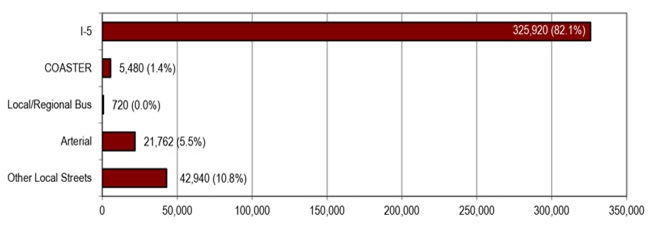
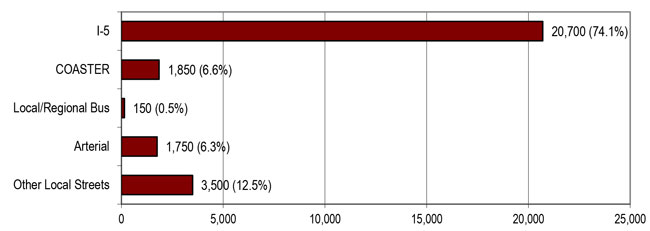
The transit mode share is slightly higher in certain parts of the corridor, reflecting the fact that regular commute trips to major employment centers are the easiest to capture with transit. Figure 5.2-2 and Figure 5.2-3 depict the overall daily and peak-period mode shares for trips across Los Peñasquitos Lagoon, a location where LOSSAN rail, I-5, and Coast Highway all converge in close proximity. Customers using I-5 account for the vast majority of trips with over 80% of the daily mode share and nearly 75% of the AM peak period. During the peak period, the COASTER mode share is much higher (6.6%) than during the overall day (1.4%), reflecting the fact that the COASTER serves two of the region's largest job centers (University City and downtown San Diego). Many other commute destinations for NCC travelers are highly dispersed, making them less conducive to transit ridership.
Source: San Diego NCC - CSMP (Chapter 4), July 2010.
Source: San Diego NCC - CSMP (Chapter 4), July 2010.
5.2.1.2 Smart Growth
The NCC traverses a largely urbanized portion of northwest San Diego County. The coastal areas generally consist of medium-density and small-lot residential developments. Northeastern San Diego County–east of the corridor and away from the coast–has experienced development at a slower (and later) pace, due in part to an early lack of necessary infrastructure and other needs. Recently, the noncoastal areas have been experiencing urbanization in the form of low-density residential developments on larger lots with ample open space.
Most of the NCC is considered nearly fully developed with urban uses. Few vacant, developable parcels of land remain in the immediate vicinity of the LOSSAN rail and I-5 corridors. In general, the coastal area of San Diego County is developed with medium-density residential and other uses, and any new growth would be accommodated by redevelopment and infill development on vacant lots. The eastern parts of the study area, however, have more available vacant developable land, and growth is in the form of larger-scale residential and commercial developments. Table 5.2-1 shows the remaining developable acres in each of the six corridor jurisdictions as well as the portion of that land planned for residential development. All jurisdictions have less than 10% of their land available for future development, with even lower percentages reserved for residential uses.
| Jurisdiction | Total Acres | Remaining Developable Land in Acres (vacant land not identified as constrained by habitat or steep slope) |
Remaining Developable Portion of Total Acres (vacant land not identified as constrained by habitat or steep slope) |
Remaining Planned Residential in Acres (vacant land planned for single-family, multi-family, mobile-home, mixed-use, or other residential uses) |
Remaining Planned Residential Portion of Total Acres (vacant land planned for single-family, multi-family, mobile-home, mixed-use, or other residential uses) |
|---|---|---|---|---|---|
| Oceanside | 26,987 | 2,275 | 8% | 1,118 | 4% |
| Carlsbad | 25,041 | 1,581 | 6% | 851 | 3% |
| Encinitas | 12,529 | 871 | 7% | 697 | 6% |
| Solana Beach | 2,183 | 37 | 2% | 28 | 1% |
| Del Mar | 1,141 | 40 | 3% | 32 | 3% |
| San Diego | 218,388 | 10,285 | 5% | 5,651 | 3% |
| Total | 286,269 | 15,089 | 5% | 8,377 | 56% |
SANDAG is the regional agency responsible for preparing population, housing, and employment projections for San Diego County, with forecasts based on the general and community plans of each of the region's jurisdictions. The 2050 Regional Growth Forecast–adopted in 2010 and used extensively to create the 2050 RTP–is a starting point for regional planning that seeks to anticipate future development patterns. It is based on regional projections and input from local cities. Each of the six municipal jurisdictions in the NCC has its own individual growth management plans or policies. These plans generally focus on managing growth to ensure that new development does not occur at the expense of the natural environment or existing development, nor before adequate infrastructure and services are in place.
Population forecasts by SANDAG and Caltrans suggest that population growth and associated development will continue in the corridor and region. Table 5.2-2 shows population growth estimates for the various jurisdictions in the NCC ranging from 14% to 31% between 2010 and 2040. San Diego, Carlsbad, and Oceanside are expected to grow the most with 31%, 23%, and 20% growth rates, respectively, while Encinitas, Solana Beach, and Del Mar have lower, but still significant, projected growth rates. Compared to the overall growth for the county (29%), most corridor cities are expected to grow more slowly, owing largely to the fact that these coastal cities are constrained by land area and are nearly fully developed already. Higher levels of anticipated growth in Carlsbad and San Diego are due to the amount of available developable land inland away from the coast on the urbanizing fringe.
| Jurisdiction | 1970 | 2010 | 2040 | Percent Change 1970-2010 |
Percent Change 2010-2040 |
|---|---|---|---|---|---|
| Oceanside | 40,494 | 179,105 | 207,237 | 342% | 20% |
| Carlsbad | 14,944 | 103,491 | 127,434 | 593% | 23% |
| Encinitas | 17,210 | 64,599 | 75,446 | 275% | 17% |
| Solana Beach | 5,744 | 13,338 | 15,619 | 132% | 17% |
| San Diego (NCC only) | 23,315 | 160,290 | 209,744 | 587% | 31% |
| Del Mar | 3,956 | 4,455 | 5,059 | 13% | 14% |
| North Coast Corridor | 105,663 | 525,278 | 647,832 | 397% | 23% |
| San Diego Region | 1,357,854 | 3,224,432 | 4,163,688 | 137% | 29% |
Growth is projected to occur not only in the NCC but throughout the neighboring regions accessed by the I-5 highway and LOSSAN rail corridors, including Orange County and Riverside County to the north, Imperial County to the east, and Baja California, Mexico, to the south. Travel demand in the NCC has been driven largely by this population and housing growth as land has become scarce within the corridor, requiring more people to commute farther distances to reach employment. Through 2050, it is forecasted that within the San Diego region 56% of new residences and 42% of new jobs will be located within a 10-minute walk of high-frequency transit stations, indicating that development of new, multimodal transportation facilities is necessary to meet these future demands.8
SANDAG's Regional Comprehensive Plan (RCP)–adopted in 2004 and currently being updated– provides the planning framework upon which local and regional decisions can be made to move the region towards a sustainable future. The RCP served as the basis for the 2050 RTP and its associated programs and provides context for local and regional decisions while balancing the needs and goals of the region. The RCP is shaped by the principles of sustainability and Smart Growth, including a policy approach that connects local and regional transportation and land use plans and develops incentives for Smart Growth planning. As part of implementing the RCP and identifying areas that may be eligible for Smart Growth incentives, SANDAG developed a Smart Growth Concept Map. This map, which is shown in Figure 5.2-1 with current transit facilities overlaid, was updated in 2012 and identifies over 200 existing and future transit-supportive and Smart Growth opportunity areas in the region. The NCC contains over 15 of these areas, the majority of which are located in community cores near COASTER and SPRINTER transit stations.
The map is being used by SANDAG's Board of Directors to prioritize transportation investments and determine eligibility for funds from the Smart Growth Incentive Program (SGIP). Funded by the voter-approved TransNet sales tax, SGIP provides local jurisdictions with funds–$280 million allocated over
40 years, which in recent years has equated to $9 million per biennial funding cycle–for planning and implementing compact, mixed-use development focused around public transit. Smart Growth principles simultaneously improve the regional transportation system's performance and support local economic and development needs. To attract developers, businesses, and residents, Smart Growth communities focus on mixed-use development by using land and infrastructure efficiently, creating pedestrian-oriented neighborhoods that are attractive and distinctive, and providing desirable transportation and housing choices that are less dependent on the automobile.
5.2.2 PWP/TREP Concerns
Transportation investments can lead to reduced travel times, improved accessibility within or among regions, and reduced accidents and air pollution. These effects can contribute to economic growth by allowing time and money previously spent on travel to be used for other purposes. However, these initial accessibility and quality-of-life benefits may be compromised by corresponding increases in population and employment growth, which can contribute to impacts beyond those directly attributable to the changes in the transportation system itself. For these reasons, proposed PWP/TREP improvements support efforts to concentrate development in developed areas with existing public infrastructure and services, including transportation facilities. This discourages sprawl into undeveloped areas–thus limiting the potential negative impacts to air quality and coastal resources, as well as slowing the growth of vehicle miles traveled (VMT)–and saves money by avoiding major expansions of public infrastructure and services into new areas.
Accordingly, SANDAG and local governments have implemented a "Smart Growth" land use strategy that seeks to increase population density to accommodate projected growth, while reducing VMT and curbing greenhouse gas emissions. However, Smart Growth must be supported by sufficient public services, and when it comes to travel, successful Smart Growth efforts depend largely on the availability of a sustainable, multimodal transportation system that is interconnected with supportive development patterns. The corridor needs an improved transportation system that includes cost-effective transit improvements, high-occupancy highway improvements, and expanded bicycle and pedestrian facilities to improve access and mobility within the NCC and beyond. This planned transportation infrastructure is a critical element to supporting Smart Growth efforts to accommodate future development within existing communities by ensuring that roads, bike routes, sidewalks, and other facilities offer safe, appealing, and comfortable travel. Absent adequate public transportation infrastructure to serve the corridor's concentrated development pattern and maintain quality of life and growth, new development could instead occur in undeveloped and rural areas if land use controls and public works allow for it.
5.2.2.1 LOSSAN Rail Corridor Impact Assessment
Public Transit
The improvements to the LOSSAN rail corridor–as well as the planned implementation of new Bus Rapid Transit (BRT) and other transit services in the NCC–would enable improved transit service with higher frequencies, shorter travel times, and more reliability. As such, the improvements would have no negative impact on public transportation. By providing an auto-competitive, public-transit alternative in the corridor, transit demand is expected to increase to more fully utilize the expanded capacity.
The proposed projects would help to accommodate existing and projected travel demand by increasing rail and bus capacity and therefore improving travel times and reliability while reducing congestion; moreover, the identified rail improvements would address potential conflicts between the planned increase in transit services and continuing freight operations in the LOSSAN rail corridor, resulting in more attractive and competitive passenger rail service in the NCC. Table 5.2-3 shows that the number of passenger trains operating in the LOSSAN rail corridor in the NCC is projected to nearly double between today and 2030 (from approximately 65 trains to 119 each weekday). Commensurate increases in frequency are planned for the supporting bus and shuttle routes that serve corridor stations (e.g., the NCTD COASTER Connection shuttles). The number of corridor freight trains is also expected to increase (from between 5 and 7 to 9 each day).
| Existing (2010) |
Near-Term (2015) Service Expansion |
Mid-Term (2020) Service Expansion |
Long-Term (2030) Service Expansion |
|
|---|---|---|---|---|
| Amtrak | 22 | 26 | 36 | 36 |
| COASTER | 22 | 30 | 36 | 54 |
| Metrolink | 16 | 16 | 16 | 20 |
| BNSF | 5-7 | 7 | 9 | 9 |
| Total | 65-67 | 79 | 97 | 119 |
Smart Growth
Regional projections show that growth of the region (and the resultant increased demand for passenger and freight service) will occur with or without the proposed PWP/TREP improvements; therefore, the LOSSAN rail corridor improvements would not have any discernible effect on projected growth in the corridor.9 However, implementing both the rail and bus transit improvements could have some localized effects on the type of development that may occur around LOSSAN rail station areas. Stations along the rail corridor would remain in their existing locations (with parking expansion and other enhancements proposed at some locations). Because the areas surrounding existing stations are mostly developed already, the increased transit service would add value to surrounding parcels and (provided local land-use policies support them) higher-value land uses. Significantly improved transit service could increase the rate of development or change the types of establishments that develop. Overall, the effects of such changes would be small given the existing and planned land uses in these suburban areas. This redevelopment would likely conform to Smart Growth principles, as it would be greater in density and focused on nearby transportation facilities.
5.2.2.2 I-5 Highway Corridor Impact Assessment
Public Transit
Planned improvements to I-5 would expand capacity and improve operations on the highway corridor to meet current and projected travel demand. Because travel times and reliability would improve for higher-occupancy modes, corridor travelers would have a greater incentive to use high-occupancy vehicles (HOV) such as carpools, vanpools, and transit buses to traverse the NCC instead of driving alone. Proposed highway improvements may, individually or cumulatively, encourage increased vehicle trips in the corridor because of improved operating conditions; however, occupancies per vehicle would be higher and therefore would lead to a much higher person throughput and more efficient use of the highway infrastructure. In addition, the Express Lanes would serve as essential enablers of high-intensity transit modes such as BRT, providing the infrastructure necessary to expand transit services in the future as demand warrants.
Smart Growth
Implementing the PWP/TREP improvements on I-5 would enhance an existing highway that serves an existing urban area as opposed to a new highway that could spur new areas of development. The project aims to maintain or improve existing and future traffic operations along I-5 while prioritizing the movement of people over the movement of vehicles.
Due to the urbanized nature of the corridor and limited availability of developable land, there is no known development potential in the corridor that would depend on implementing the proposed highway improvements. As such, growth in the project area and surrounding region is expected to occur with or without the implementation of the proposed project.
As shown in Table 5.2-1, only 5% of the land within the six jurisdictions in the study area is considered available for future development, of which nearly half is planned for residential uses. The few undeveloped, vacant properties surrounding I-5 have been identified as infill redevelopment projects, city-approved projects, or protected open space.
Local jurisdictions along the I-5 highway corridor have identified growth forecasts and anticipated maximum build-outs within their local planning documents and implementing guidelines, including the cities' certified Local Coastal Programs (LCP) discussed in Chapter 2. These plans and policies generally focus on managing growth to ensure that new development does not occur at the expense of the natural environment, coastal resources, or existing development, nor before adequate infrastructure and services are in place.
The existing I-5 highway corridor experiences severe congestion during peak hours; the proposed project is intended to relieve both the existing and anticipated future increases in congestion. The design of the project was coordinated with regional growth forecasts based on approved land use plans. To contain costs and environmental impacts, project design does not provide for excess capacity beyond planned growth. Given the built-out land use pattern in corridor cities (as discussed in Section 5.2.1.2), the limited availability of developable land, local land use and regional policies controlling future growth, and the costs associated with redevelopment, the proposed highway improvements would have minimal potential to result in growth-inducing impacts.
The potential for moderate growth in the project vicinity is inevitable and consistent with local land use plans and current trends. The benefits associated with the proposed project would not substantially affect the location, rate, type, or amount of growth in the project vicinity because of other limits on growth, including land use controls within local and regional plans and policies, and the highly urbanized nature of the existing land use.
Alternatively, without adequate public infrastructure (including transportation facilities) to serve the corridor's concentrated development pattern and maintain quality of life and growth, new development could occur instead in undeveloped and rural areas outside the corridor such as the inland cities and unincorporated areas to the east. Beyond the negative regional effects of increased VMT and greenhouse gas emissions that would result from such sprawling development, coastal resources in the NCC could also be affected by increased vehicle trips to and from rural areas to reach the common public and commercial support services and coastal recreation areas. In addition, whatever development would occur in the coastal areas would likely experience increased traffic congestion and associated degradations in both air quality and quality of life.
5.2.3 PWP/TREP Opportunities, Design/Development Strategies, and Policies/Implementation Measures
While the corridor population and travel are expected to increase over the next 30 years, this growth will occur regardless of whether the PWP/TREP program of improvements is implemented. The regional goals of livability and sustainability require a healthy economy, improved and efficient mobility, and reliability of the transportation systems that serve to connect the local communities. By allowing approved and concentrated growth to occur in the already urban corridor (supported by sufficient public infrastructure and services), additional growth is not forced to spill over into undeveloped or rural areas. Focusing investment on facilities that encourage alternative modes of transportation–such as improving the existing LOSSAN rail corridor, introducing Express Lanes on I-5 that encourage HOVs and allow for transit vehicles, or developing bike lanes and sidewalks–will concentrate future growth in urban areas where corresponding travel demand can be accommodated by a combination of these alternative modes of transportation.
5.2.3.1 Corridor Opportunities
As stated previously, growth within the project area is expected to occur under any circumstance with or without the proposed project. The potential for moderate growth in the project vicinity is inevitable and consistent with local land use plans and current trends. Transportation infrastructure improvements proposed by the PWP/TREP would support new and expanded transit services and improve multimodal travel options, which would facilitate the region's Smart Growth efforts as a sustainable means of accommodating growth in the corridor. The PWP/TREP includes transportation system improvements that address the needs of people who travel on foot and via public transportation and bicycles, ensuring that the transportation system facilitates walking, riding bikes, and riding buses and trains as a safe and easier means of travel–a critical element of successful Smart Growth policies.
Improvements to the corridor's main north-south routes would accommodate existing and future travel demand that results from projected growth in the NCC's population and employment. The proposed project would improve reliability and reduce travel time on both the LOSSAN rail corridor and the I-5 Express Lanes, which would provide incentives to travelers to use rail as well as other transit services (such as buses and carpools) that would utilize the proposed Express Lanes and direct access ramps (DARs). In addition, the proposed infrastructure improvements would provide new opportunities to develop and improve bike lanes, sidewalks, and trails, which would encourage non-vehicular travel in the corridor.
The proposed Manchester Avenue DAR and San Elijo Multi-Use Facility (consisting of a park-and-ride, BRT station, and recreational amenities such as parking and trailheads) would provide direct access to the I-5 Express Lanes for HOVs, carpools/vanpools and transit vehicles, including BRT services that may be added in the future as demand increases. The DAR would prevent these vehicles from having to weave through congestion in the I-5 general-purpose lanes when entering or exiting the highway, which would not only shorten travel time for transit and HOVs but would also reduce travel demand on the highway's general-purpose lanes. The park-and-ride/BRT station would include a new access road, parking for about 150 cars, and a bus platform–all of which would facilitate ridesharing and bus transportation.
Traffic congestion on I-5 inhibits many potential carpool, vanpool, and bus transit options, as these modes of travel are subject to the same traffic congestion on the highway that single-occupancy vehicles (SOVs) experience. The combination of increased support facilities–such as the DAR and the park-and-ride/BRT station–along with the proposed Express Lanes would provide strong incentives for travelers to shift to ridesharing and public transit, as these modes would be easier to access and would possess a major advantage over SOV travel: direct access to the uncongested Express Lanes, where reduced travel times and increased reliability would be assured. Accordingly, the proposed PWP/TREP improvements would encourage alternative transportation modes as viable substitutes for SOV travel.
The LOSSAN rail corridor improvements would lead to shorter travel times and improved reliability, and would enable increased frequencies for inter- and intra-city public transit in the corridor. The improvements would provide a track in each direction in nearly the entire corridor, thereby allowing for an increase to corridor capacity to over 47,000 passengers each day.10 Station facilities and parking improvements at, adjacent to, or in close proximity to LOSSAN rail corridor stations would further increase passenger capacity and enhance the quality of service. LOSSAN rail corridor improvements would also provide enhanced inter- and intra-regional access to coastal-dependent industry and recreation, coastal and upland areas supporting recreation, various tourist destinations, and visitor-serving areas. Providing higher-quality rail service in the LOSSAN rail corridor is one of the public infrastructure elements necessary to fully realize Smart Growth potential in areas around LOSSAN rail corridor stations.
5.2.3.2 PWP/TREP Policies, Design/Development Strategies, and Implementation Measures
The proposed improvements would maintain and enhance public access to the coast by improving public transit in the corridor with reliable, uncongested transit service, Express Lanes, and DARs, and by providing for non-automobile circulation throughout the corridor with new and improved bike lanes, sidewalks, and trails. In addition, implementing the PWP/TREP would limit the expansion of the public works facility to within the established corridor serving existing, permitted, and planned development according to approved land use plans. As the proposed new highway facilities, rail track and station improvements, and pedestrian crossings–as well as the associated community and resource enhancements–inherently address potential transit and growth issues identified by applicable Coastal Act policies, no policies, design/development strategies or implementation measures are necessary to further ensure PWP/TREP consistency with the Coastal Act.
As discussed in Chapter 6, to coincide with the monitoring reports that SANDAG prepares for regularly updated regional transportation and growth plans, a transportation report package will be submitted every four years in order to provide details on improvements to the entire NCC transportation system as described in the PWP/TREP. The report will provide an overall picture of the progress made during the reporting period toward meeting the 30-year transportation goals expressed by the regions within regional plans and the PWP/TREP. The report will consider a variety of factors to track overall enhancements to the transportation system within the corridor, particularly those necessary to ensure that positive steps toward improved connectivity and mass transit are developed to reduce vehicle miles traveled and energy usage as described in the PWP/TREP. It will include updates on capital improvements, an accounting of dollars invested, changes in transportation trends, and information on other transportation strategies implemented through the corridor. The report will also include descriptions of areas where measurable enhancements have been realized as well as areas where the results do not meet expectations, an analysis of the factors behind those results, and potential adaptive management solutions for improvements where necessary. Moreover, the report will provide a reassessment of land-use changes over time and identify new opportunities for improved transit services as a result of those changes.
5.2.4 Coastal Act Consistency
Coastal Act Section 30250 requires new development to occur in already developed areas and areas with adequate public services. This requirement is intended to concentrate development away from undeveloped rural areas and thus avoid significant adverse effects, either individually or cumulatively, on coastal resources:
- (a) New residential, commercial, or industrial development, except as otherwise provided in this division, shall be located within, contiguous with, or in close proximity to, existing developed areas able to accommodate it or, where such areas are not able to accommodate it, in other areas with adequate public services and where it will not have significant adverse effects, either individually or cumulatively, on coastal resources. In addition, land divisions, other than leases for agricultural uses, outside existing developed areas shall be permitted only where 50 percent of the usable parcels in the area have been developed and the created parcels would be no smaller than the average size of surrounding parcels.
- (b) Where feasible, new hazardous industrial development shall be located away from existing developed areas.
- (c) Visitor-serving facilities that cannot feasibly be located in existing developed areas shall be located in existing isolated developments or at selected points of attraction for visitors.
Coastal Act Section 30252 encourages the development of non-automobile public access to the coast to reduce demand on coastal access roads:
The location and amount of new development should maintain and enhance public access to the coast by (1) facilitating the provision or extension of transit service, (2) providing commercial facilities within or adjoining residential development or in other areas that will minimize the use of coastal access roads, (3) providing non-automobile circulation within the development, (4) providing adequate parking facilities or providing substitute means of serving the development with public transportation, (5) assuring the potential for public transit for high-intensity uses such as high-rise office buildings, and by (6) assuring that the recreational needs of new residents will not overload nearby coastal recreation areas by correlating the amount of development with local park acquisition and development plans with the provision of onsite recreational facilities to serve the new development.
Section 30254 limits constructing or expanding public works facilities to the capacity generated by permitted development:
New or expanded public works facilities shall be designed and limited to accommodate needs generated by development or uses permitted consistent with the provisions of this division; provided, however, that it is the intent of the Legislature that State Highway Route 1 in rural areas of the coastal zone remains a scenic two-lane road. Special districts shall not be formed or expanded except where assessment for, and provision of, the service would not induce new development inconsistent with this division. Where existing or planned public works facilities can accommodate only a limited amount of new development, services to coastal dependent land use, essential public services and basic industries vital to the economic health of the region, state, or nation, public recreation, commercial recreation, and visitor-serving land uses shall not be precluded by other development.
5.2.4.1 Public Transit
The planned transit improvements would result in shorter travel times and improved reliability, and would enable increased frequencies for inter- and intra-city public transit in the corridor. With close to half of the LOSSAN rail corridor operating on a single track with no passing track, the improvements
(implemented in multiple projects) would lead to double-track in nearly the entire corridor. These phased projects are required to accommodate the planned increase in LOSSAN rail corridor services over the next several decades (Table 5.2-3). By 2030, COASTER service is planned to nearly double, with the capacity to serve up to 35,000 passengers daily; the overall capacity in the corridor is expected to be 47,000 passengers per day across all rail services.
Station facilities and parking improvements at, adjacent to, or in close proximity to LOSSAN rail corridor stations would increase passenger capacity and enhance the quality of service. The new Del Mar Fairgrounds Special Event Platform would provide for improved non-automobile access to coastal resources, including Cardiff State Beach, San Dieguito River Park, and Lagoon, and the Del Mar Racetrack and Fairgrounds. Parking structures or significant expansions to parking facilities would be planned at, adjacent to, or in close proximity to all NCC stations (Oceanside, Carlsbad Village, Carlsbad Poinsettia, Encinitas, Solana Beach, and Sorrento Valley). Parking at stations is a major capacity constraint and acts as a barrier to many potential rail corridor users. On average, all of the COASTER station parking lots (except Oceanside and Sorrento Valley) are at least 90% full on weekdays, with several exceeding 95%.11 This constraint not only limits the number of people who can access the stations by automobile, but it also creates uncertainty among potential new riders, who might wish to commute via rail but cannot rely on parking being available every day. This lack of parking capacity, therefore, serves as a barrier to increased ridership. Providing additional parking resources at NCC rail stations will be a critical component to supporting increased rail use in the future.
The I-5 highway corridor improvements would prioritize access by HOVs and transit vehicles, thus incentivizing their use. The corridor's two Express Lanes in each direction would provide reliably uncongested travel to HOVs, vanpools, buses, and other transit vehicles using I-5. Any additional capacity in the Express Lanes would be available to SOVs for a fee, which would ensure that excess capacity in the lanes is not wasted and that the benefits of overall decreased traffic congestion for all trip types are realized. The price for SOVs would vary in real-time (based on the use of the Express Lanes) to ensure that they remain uncongested. Revenues collected would be allocated to further improve corridor transportation services. Compared to the No-Build Alternative, adding Express Lanes to the I-5 corridor for the 2030 Build Alternative would nearly double HOV volumes during peak periods in the peak direction (Table 5.2-4).
| From / To | AM Peak Existing (includes current baseline information) |
AM Peak 2030 No Build (includes ongoing operations and maintenance and separate projects in the corridor through 2030) |
AM Peak 2030 Build |
PM Peak Existing (includes current baseline information) |
PM Peak 2030 No Build (includes ongoing operations and maintenance and separate projects in the corridor through 2030) |
PM Peak 2030 Build |
|---|---|---|---|---|---|---|
| Northbound I-5/I-805 Junction to Carmel Valley Road |
300 | 1,920 | 2,000 | 1,100 | 1,620 | 2,540 |
| Northbound Carmel Valley Road to Lomas Santa Fe Drive |
300 | 1,580 | 1,640 | 1,100 | 1,230 | 2,130 |
| Southbound Lomas Santa Fe to Carmel Valley Road |
1,200 | 1,030 | 2,400 | 350 | 1,010 | 2,030 |
| Southbound Carmel Valley Road to I-5/I-805 Junction |
1,200 | 1,030 | 2,800 | 350 | 1,480 | 2,430 |
The 2050 RTP includes plans for a "reverse commute" BRT service on I-5 that would serve the peak-period commute trip between the high-density Mid-City residential area in central San Diego and the Palomar Airport Road business park in the NCC. Other transit services utilizing the Express Lanes– several of which were evaluated during the 2050 RTP planning process–could be added as travel demand increases in the corridor.
The LOSSAN rail corridor is used mostly for commuter and intercity travel, but with improvements in the frequency and span of service, it could serve other types of trips, including recreation and leisure trips for local users. All six LOSSAN rail stations in the NCC are within blocks of a major coastal resource–either a public beach or lagoon. The reliability and travel times of the highway Express Lanes and corresponding facilities would provide users of the highway system with a similar incentive to use higher-occupancy modes of transportation in the corridor, including bus transit services that are planned for future implementation. These facilities would allow for the provision of public transportation to coastal areas–which are underserved, including those areas of the NCC less accessible to LOSSAN rail corridor stations–as well as trips with origins or destinations that could not be served easily by the rail corridor. These corridor improvements would provide enhanced inter- and intraregional access to coastal-dependent industry and recreation, coastal and upland areas supporting recreation, various tourist destinations, and visitor-serving areas, which would maintain and enhance critical public transport services for industries vital to the economy of the region, state, and nation.
Proposed community enhancements would further support non-automobile transportation. Bike and hiking trails, including components of the Coastal Rail Trail, pedestrian corridor crossings, adding and widening of overpass sidewalks and bike lanes, upgraded and expanded parking facilities at, adjacent to, or in close proximity to rail stations, grade separations, and other improvements would create stronger links in the corridor. Many of these new links would significantly improve non-vehicular public access to and within the Coastal Zone and to recreation areas, making access by alternative transportation modes more desirable. These enhancements are discussed in detail in Section 4.4.1.
The proposed PWP/TREP multimodal program focuses on implementing transportation improvements that would meet the region's varied transportation needs, including rail, bicycle, and pedestrian facilities. While each of these non-highway improvements would increase corridor capacity, collectively, they would still not accommodate expected corridor travel growth or avoid highway improvements that will be critical to maintaining an efficient transportation system in the NCC that meets the travel demands of residents, commuters, visitors, and goods movement.
Planned improvements to the NCC would help provide coastal public-transit access and would provide for greater non-automobile circulation within the corridor. I-5's Express Lanes and DARs would provide priority service for buses and other transit vehicles as well as HOVs. Future bus routes using this infrastructure would enable direct access to coastal resources. Additionally, trips otherwise made by private automobile could use these new services and thereby provide additional capacity for other vehicles to access the coast. Reduced LOSSAN rail travel times, increased frequencies, and improved weekend and off-peak service would make rail more competitive with the automobile as an access mode for coastal resources. Many of the corridor's bicycle and pedestrian routes are disjointed because of topographical and infrastructure barriers. The proposed project improvements would create or materially improve many of these necessary connections, including 26 highway over- and under crossings that would be rebuilt with the improved bike and pedestrian facilities. By developing pedestrian bridges and corridor bike and hiking trails (and adding and enhancing sidewalks and bike lanes), safe, non-automobile-dependent routes to and within the Coastal Zone would be provided. As such, the proposed NCC improvements are consistent with Section 30252 of the Coastal Act.
5.2.4.2 Growth
Providing higher-quality rail service in the LOSSAN rail corridor is one of the public infrastructure elements necessary to fully realize Smart Growth opportunities around LOSSAN rail corridor stations. Developing a transportation system that facilitates riding bicycles and walking as safe and easy means of travel to and from transit opportunities is also a critical component of successful Smart Growth policies. Accordingly, the PWP/TREP incorporates several pedestrian and bicycle improvements identified during the development of the Safe Access to Transit and Coastal Resources (SATCR) study, which is included as Appendix A of the PWP/TREP. As described in Chapter 2 and Section 5.3, SANDAG and Caltrans conducted the SATCR study during the PWP/TREP planning process to identify gaps or barriers within the regional and local bicycle and pedestrian networks that limit bicycle and pedestrian access to transit services and coastal resources in the NCC. During the study, the identified gaps and deficiencies–particularly those that inhibit east-west crossing of the highway and rail corridors–informed the NCC planning process and resulted in the incorporation of many pedestrian and bicycle improvements into the PWP/TREP (to be implemented concurrently with the highway and rail projects).
These pedestrian and bicycle improvements would improve safety and accessibility for mass transit riders who walk or bike to transit facilities and would also increase overall community walkability in areas surrounding transit stations that are planned for Smart Growth. During its development, the SATCR study identified the needs of pedestrians and cyclists that extend beyond the corridor's transit stations to and from the surrounding neighborhoods and then identified adjacent PWP/TREP elements that presented opportunities to address these needs. By influencing the selection and design of project elements, the SATCR process contributed to the broad suite of the pedestrian, bicycle, and community enhancements that are included in the PWP/TREP (described in more detail in Chapter 3B, Chapter 4, and Section 5.3). These transit-friendly pedestrian and bicycle improvements, combined with the LOSSAN rail projects and other investments in corridor transit, will collectively support Smart Growth in the NCC, which will, in turn, ensure that future growth can be accommodated with a mix of uses that enable nonauto-oriented development. With a mix of uses in a concentrated area, many trips can be made on foot or bicycle. Destinations farther away could be reached by using regional transit systems. An improved rail corridor would support Smart Growth development.
Improvements to the corridor's main north-south highway would accommodate existing and future travel demand resulting from projected population and employment growth. Accommodating some of this travel demand in the I-5 highway corridor would have multiple benefits. As facility improvements focus on non-SOV travel, growth in travel could be accommodated by a higher percentage of transit options and HOVs, meaning that each individual person-trip would have a smaller impact as the ratio of people to vehicles increases. Addressing future I-5 congestion would alleviate the need to accommodate existing and future vehicles on the Coast Highway and other arterial streets that could otherwise require widening or other improvements, resulting in significant impacts to coastal communities and to public recreational areas. Providing corridor access by addressing congestion on I-5 would allow infrastructure to support planned growth in the already developed corridor as infill and redevelopment. If public services in the corridor are insufficient to accommodate existing or additional development, growth would likely encroach into rural and undeveloped areas as people seek to improve quality of life. By enabling growth in already developed areas, significant impacts on natural areas are averted.
Growth within the project area is projected to occur with or without the proposed improvements.12 Growth is considered to have an indirect relationship to the proposed project that cannot be directly minimized through alternate project features or design. However, by improving public services, especially transit, in an already developed corridor planned to absorb regional growth, growth would occur in these areas–instead of in further sprawling land-use patterns that develop natural or rural areas–therefore limiting impacts to natural resources. SANDAG estimates that nearly 80% of future job and housing growth will occur within the region's already developed urbanized areas, which include the coastal cities of the NCC.13 The regionally projected growth in the NCC supported by the proposed infrastructure improvements would mostly be infill or redevelopment. Previous Coastal Commission decisions have found that concentrating development in already developed areas supports transit services and opportunities. Capacity enhancements in the NCC would ensure that the corridor is able to support the regionally planned growth. The potential for moderate growth in the project vicinity is inevitable and consistent with local land use plans and current trends; therefore, no adverse effects associated with growth are anticipated by implementing the PWP/TREP.
5.2.4.3 Coastal Act Consistency Analysis Summary
The proposed rail, highway, and community enhancement projects would increase travel capacity in the corridor, thereby reducing travel times and improving the quality of service. Although such improvements could induce growth in other regions or corridors, the NCC is almost entirely built-out and contained by natural and jurisdictional borders including the Pacific Ocean to the west, Camp Pendleton to the north, dense University City and downtown San Diego to the south, and the I-15 travel shed to the east. By providing improved public services to an existing corridor, the development would be concentrated and supported by existing public services and thereby would limit development sprawl into undeveloped areas. Any new development in the corridor would be located within, contiguous with, or in close proximity to existing development and public infrastructure. Any growth that would occur in the NCC and that would be served by the proposed infrastructure improvements would be infill or redevelopment. This growth would actually replace growth that otherwise would occur outside the corridor at the urban fringe or beyond, leading to the development of rural lands. As unplanned growth would not be induced by these improvements (and therefore the increase in capacity would not have any indirect impacts on other public services), the improvements would be consistent with Coastal Act Section 30250.
Proposed planned improvements to the LOSSAN rail corridor and the I-5 highway corridor would also improve rail and traffic operations. To be found consistent with Coastal Act Section 30254, the proposed program must serve existing development, or if it accommodates new development, such development must be at planned and approved densities. The proposed LOSSAN rail and I-5 highway corridors' improvements would be located within a developed urban area and would provide safe and adequate travel circulation for growth that is already planned and anticipated. The regionally projected growth that would occur in the NCC would be supported by the proposed infrastructure improvements. These regional growth projections concentrate and maintain anticipated development growth within and/or contiguous to the existing developed corridor and reduce development pressure on rural or undeveloped lands. Proposed improvements would not induce new or unplanned growth within the Coastal Zone. As such, the LOSSAN rail corridor and I-5 highway corridor development are consistent with Section 30254.
Based on available project and environmental data and policies and implementation measures included herein, the proposed PWP/TREP improvements would concentrate development in already developed areas, encourage the development of non-SOV access to the coast, and limit the capacity of the proposed public works facilities to serve only permitted development; therefore, the PWP/TREP is consistent with Sections 30250, 30252 and 30254 of the Coastal Act.
5.2.5 Local Coastal Program Consistency
For LOSSAN rail corridor projects included in the PWP/TREP that improve the movement of freight, the LCP policy consistency analysis provides guidance or background information for analyzing rail project consistency with Sections 30250, 30252 and 30254 of the Coastal Act, as appropriate and applicable (see Chapter 1 for additional discussion of LCP applicability to rail projects that may fall under the exclusive jurisdiction of the Surface Transportation Board). The corridor's LCP transit and Smart Growth policies are summarized with brief city-specific consistency analyses below. These integrate and supplement Sections 30250, 30252 and 30254 of the Coastal Act.
5.2.5.1 Local Coastal Program Consistency Analysis Summary
Some of the certified LCPs in the corridor include policies that mirror the requirements of Sections 30250, 30252, and 30254 of the Coastal Act; however, the LCPs for San Diego, Encinitas, Carlsbad, and Oceanside also include additional and specific policies and development standards that support a multimodal approach to transportation and ensure that new growth is supported by adequate public infrastructure.
City of San Diego
The City of San Diego LCP contains Smart Growth and public-transit policies in the North City Land Use Plan, in addition to some of the individual community plans affected by the proposed PWP/TREP improvements. The City's LCP includes several policies that address concentrating development in already developed areas where infrastructure, transportation, commercial, and recreational options exist. The LCP policies also focus on improving access to public transit and providing a balanced transportation system that serves multiple modes. The LCP, with its collective plan components, includes Smart Growth and transit policies that are particularly unique to this portion of the corridor as follows:
-
North City Land Use Plan
- Improve public transportation between La Jolla and the rest of metropolitan San Diego.
-
Torrey Pines Community Plan
- Public mass transit services, including bus, light rail, and commuter rail should be provided to and through the Torrey Pines community.
-
Torrey Hills Community Plan
- Support the provision of secure park-and-ride facilities in the vicinity of access points to the major regional transportation facilities.
- Expand transit services to Torrey Hills.
-
University Community Plan
- Encourage alternative modes of transportation by requiring developer participation in transit facility improvements, the Intra-Community Shuttle Loop and the light rail transit (LRT) line.
- Encourage the development of a high-speed, LRT system to serve the university community and other northern communities.
-
North City Future Urbanizing Area (NCFUA) Framework Plan
- The community cores should contain dedicated transit rights-of-way for BRT or LRT service, providing access to the regional transit system. Where feasible, local feeder-bus or shuttle service should be provided to connect the residential areas with the community core. Development of a local transit center where trunk-line and feeder-bus service connect is encouraged and should be located in the community core.
- Create a land use and circulation pattern that supports multimodal travel habits for people living and working in the NCFUA. Give preference to transit on congested road segments.
- The North City West Community Plan designates a regional transit terminal at El Camino/Del Mar Heights Road. The NCFUA transit service should connect with this and other links to the regional transit network.
- Practical and convenient alternatives to the automobile should be provided at the time of need by providing transit stops, buses, signage, and other improvements.
PWP/TREP improvements would improve public transit access (directly or indirectly) to all of the community plan areas in San Diego's North City. Although not all of the proposed services would be provided with the program of projects included in the PWP/TREP, the LOSSAN rail corridor improvements, the addition of Express Lanes that enable BRT, and the provision of a continuous bike and pedestrian routes would enhance the public-transit network in the corridor. As such, these policy requirements do not present potential policy conflicts and would not require that policies be amended to ensure consistency of the PWP/TREP improvements with the certified LCP.
City of Encinitas
The City of Encinitas LCP encourages an integrated, convenient, diverse transportation system, including expanding public transit and emphasizing it in future development while preserving community values and character. This includes promoting other modes of transport to reduce dependence on the personal automobile, encouraging shuttle service and park-and-ride facilities, and cooperating with San Diego County and SANDAG to help plan and implement a regional multimodal transportation system that is accessible to residents in the city.
The City of Encinitas LCP also indicates that the land occupied by the LOSSAN rail and I-5 highway corridors is to be reserved and protected for transportation purposes, and will not allow development or encroachment of any other private use, structure or facility. Compatible public uses, facilities and support spaces such as landscaping, localized street widening or realignment, development of a "linear park," public automobile parking or shared parking in a public district, and pedestrian, bicycle, or trail facilities may be considered. Additionally, the areas adjoining the highway corridor are to remain as low-density residential while preserving the best natural features–thus avoiding the creation of a completely urbanized landscape–and maintaining I-5 interchange areas to conform to the specifications of this overall goal.
PWP/TREP improvements would encourage a multimodal transportation system. The DAR included at Manchester Avenue and the adjacent San Elijo Multi-Use Facility would enable the development and efficient use of park-and-ride facilities by auto travelers as well as any future bus services that are added as travel demand grows. The lands used by the LOSSAN rail and I-5 highway corridors would remain as transportation facilities, and adjacent projects would be compatible public uses, including the provision of parallel and complementary bike and pedestrian paths that connect to important coastal resource areas. Smart Growth is anticipated to occur around the LOSSAN rail corridor station–one of the regional Smart Growth areas identified by SANDAG–and not along the low-density residential I-5 highway corridor. As such, these policy requirements do not present potential policy conflicts and would not require that policies be amended to ensure consistency of the PWP/TREP improvements with the certified LCP.
City of Carlsbad
Although the Agua Hedionda Lagoon segment of the City of Carlsbad's LCP remains an area of deferred certification, the City of Carlsbad's certified Agua Hedionda Land Use Plan (LUP) provides guiding policy to address development therein, including Policy 7.12, which states:
Public transit availability shall be provided as follows:
- As land within the Specific Plan area develops, the North County Transit Company bus system should be expanded to provide optimum levels of service.
- Future street systems within the Specific Plan area shall be constructed in a manner that can accommodate the public bus system.
- Accessory facilities, such as bus turnouts, shelter and benches shall be provided at key locations along the existing and future bus routes.
PWP/TREP improvements would provide for increased public-transit availability through the provision of a multimodal transportation system that accommodates increased bus, carpool/vanpool, HOV, and rail activity in accordance with the regional vision identified within the 2050 RTP. As such, this policy does not present a potential conflict, and would not require an amendment to ensure consistency of the PWP/TREP improvements with the certified LCP.
City of Oceanside
The City of Oceanside LCP has as an objective to "endorse infilling and revitalization of the Coastal Zone for the purpose of creating an attractive, balanced and economically sound urban environment." Supporting policies include promoting the development of a high level of transportation facilities, public services, and amenities, such as supporting continued high levels of NCTD service and supporting expansion and upgrades of Amtrak service, commensurate with travel demand. Additionally, new development is conditional on essential public facilities being able to serve the demands of the growth.
PWP/TREP improvements would provide public services in the form of transportation, which could enable infill development in Oceanside. Improvements to the LOSSAN rail corridor would provide the capacity necessary to increase NCTD, Metrolink, Amtrak, and freight services. As such, these policy requirements do not present potential policy conflicts and would not require that policies be amended to ensure consistency of the PWP/TREP improvements with the certified LCP.
Summary
Based on available project and environmental data and the policies and implementation measures included herein, the proposed PWP/TREP improvements would focus any induced development in already developed areas, enhance non-automobile public access to the coast, and limit the expansion of the proposed public works facilities to the capacity generated by permitted development through the programming and design of improvements and the application of reasonable mitigation measures; therefore, the PWP/TREP is consistent with applicable Smart Growth and public transportation policies of the corridor LCPs, and policies would not need to be amended to implement the proposed transportation facility improvements.
Notes:
- NCTD, November 2012. See Section 3A.1.2.5.
- SANDAG, January 2013.
- SANDAG Coordinated Plan 2012-2016 (Appendix C), July 2012.
- SANDAG Coordinated Plan 2012-2016 (Appendix C), July 2012.
- The "last mile" (or "first mile") refers to the access gap between transit services and a trip's origin or destination. This is often cited as a reason more people do not ride transit: It can get riders close, but not close enough, for many trips.
- "iCommute Vanpool Program Hits Record-High Participation," Region (SANDAG's e-newsletter), October 2011. http://www.sandag.org/enewsletter/archives/october2011/feature_2.html. Accessed April 27, 2012.
- SANDAG 2050 RTP (Technical Appendix 7), October 2011.
- SANDAG 2050 Regional Growth Forecast, February 2010.
- LOSSAN Final Program EIR/EIS (Section 3-15), September 2007.
- SANDAG, May 2012.
- NCTD, November 2012. See Section 3A.1.2.5.
- LOSSAN Final Program EIR/EIS (Section 3-15), September 2007.
- SANDAG 2050 RTP (Chapter 3), October 2011.