
PWP/TREP Overview
North Coast Corridor Public Works Plan/Transportation and Resource Enhancement Program
Prepared by:
- Caltrans, District 11
- San Diego Association of Governments
- With support from:
- Parsons Brinckerhoff
- Dudek
Draft Amendment #1 December 2015
PWP/TREP Overview
Table of Contents
- Introduction
- Why A Public Works Plan - Chapter 1
- Existing Conditions, Programs, Policies, and Strategies - Chapter 2
- Corridor Deficiencies - Chapter 3A
- The Corridor Solution - Chapters 3B and 4
- Movement of People Rather Than Vehicles
- Enhancing Coastal
- Preserving and Enhancing Community & Coastal Character
- Preserving, Restoring and Enhancing Sensitive Coastal Habitat
- Coastal Development Policies and Resources - Chapter 5
- Project Implementation - Chapter 6
- Conclusion and Next Steps
- California Coastal Act Policy Conflict Resolution
- Next Steps
North Coast Corridor Public Works Plan/Transportation and Resource Enhancement Program Overview
Introduction
The Northern San Diego County coastal communities were established around the coastal rail line nearly 125 years ago. As transportation options increased with the introduction of the automobile and the region's population continued to grow, the North Coast Corridor (NCC) took on added importance as a pathway to adventure and prosperity in the region. As one of only two north-south transportation corridors in Northern San Diego County, the NCC is a critical lifeline for the San Diego region, providing internal mobility as well as a connection to neighboring counties. This is especially important given San Diego's location in the southwest corner of the United States, which makes it the "front door" to the state of California and the nation (Figure 1). The NCC also extends along and provides primary access to, 27 miles of coastline that contains some of the largest remaining coastal wetlands in California. In addition to coastal wetlands, the NCC boasts many other scenic and heavily used coastal resources such as sandy beaches, offshore reefs, marinas, and a number of other recreational facilities that support sport fishing, picnicking, boating, swimming, and natural resource and education centers.
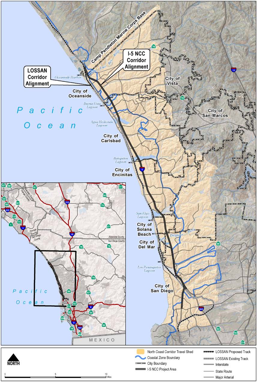
Figure 1: Regional and North Coast Corridor Map
The coastal resources, regional attractions, and vital connections in the NCC generate a variety of transportation needs that put a significant strain on the corridor. In fact, on an average day, Interstate 5 (I-5) alone serves more than 700,000 trips, including commuters, goods movement, local trips, visitors, and recreational users. Unfortunately, these users typically encounter significant congestion, increased travel times, decreased reliability, and limited travel choices. As San Diego and California continue to grow, these problems will get worse, affecting the region's quality of life and inhibiting coastal access and economic growth in the San Diego region and beyond.
The challenge is how to address these critical transportation improvements and how to do so in a way that protects and enhances the coastal resources and coastal character of the NCC–the very qualities that make the corridor an attractive place to live, work, visit, and recreate. Additionally, given the rapidly evolving world, transportation improvements need to be flexible enough to address future changes in technology, land use, and funding, and should be implemented through a balanced approach that ensures that the improvements are consistent with California law. In addition, the necessary transportation improvements in the NCC will cross numerous jurisdictional boundaries, adding an additional level of complexity to implementation. Given their scope, cost, and complexity, the transportation improvements will need to be implemented in phases.
To meet this challenge, the San Diego Association of Governments (SANDAG) and the California Department of Transportation (Caltrans) have been collaborating with the California Coastal Commission (Coastal Commission), local cities, resource agencies, and the public to develop the NCC Public Works Plan/Transportation and Resource Enhancement Program (PWP/TREP), which lays out a blueprint for implementing a $6-billion 40-year program of rail, highway, transit, bicycle, pedestrian, and coastal resource improvements that span 27 miles of the Northern San Diego County coastline from La Jolla to Oceanside.
Consistent with the 2050 Regional Transportation Plan (2050 RTP), the NCC PWP/TREP improvements would create a balanced multimodal system and enhanced coastal environment through three main components:
- Significant rail and highway infrastructure improvements.
- Enhanced and newly established bicycle and pedestrian coastal access routes.
- Preserved, restored and enhanced sensitive coastal habitat through significant water quality, lagoon, and natural habitat improvements.
By looking at the NCC's rail, highway, coastal access, and environmental deficiencies holistically, new opportunities are provided that will significantly benefit public access and sensitive coastal resources in the corridor. The PWP/TREP would improve conditions for coastal resources by enhancing public transit and non-motorized transportation alternatives to reduce energy consumption and air emissions (resulting in improved air quality), and would implement improvements to the existing transportation system that eliminate existing impediments and enhance coastal access opportunities for residents and visitors. The PWP/TREP improvements will foster healthy and sustainable coastal communities further by limiting traffic congestion on local streets, minimizing energy consumption and air and greenhouse gas (GHG) emissions related to travel and improving the transportation system in a way that supports the concept of Smart Growth as a means of accommodating anticipated future growth in the NCC.
Why A Public Works Plan - Chapter 1
In 1972, the United States Congress passed the Coastal Zone Management Act (CZMA) with the overall goal to "preserve, protect, develop, and where possible, restore or enhance the resources of the nation's coastal zone." In 1976, the California State Legislature adopted the California Coastal Act (Coastal Act) to implement the CZMA. The Coastal Act is the foundation of the California Coastal Management Program, which includes the basic policies for managing and balancing the use of resources for state and national interests in California's Coastal Zone. Development activities requiring a coastal development permit in the Coastal Zone are regulated by the Coastal Commission and local governments through their respective coastal development permit processes. A PWP is an entitlement for approval of public works projects, which remains under the authority of the Coastal Commission irrespective of coastal permit jurisdictional boundaries, and is an alternative to project-by-project review for public works that could otherwise require multiple coastal development permits for different components of a public works project.
The NCC PWP/TREP, jointly prepared by SANDAG and Caltrans, is a single integrated document that establishes a framework for comprehensively planning, reviewing, and permitting of the NCC's transportation, community, and resource enhancement projects. The PWP/TREP allows these improvements to be analyzed as an integrated system, to optimize the suite of improvements so that transportation goals are met in a manner that maintains and enhances public access to coastal resources and recreational facilities and sensitive coastal resources are protected and enhanced wherever feasible. The PWP/TREP also serves as the regulatory document that provides a comprehensive mechanism for conducting a federal consistency review under the CZMA for all of the NCC improvements, and for coastal development permitting and processing of applicable local coastal program (LCP) amendments pursuant to the Coastal Act for those elements of the PWP/TREP subject to PWP requirements. In addition, the PWP/TREP links and identifies mitigation measures for project elements within lagoon areas that are subject solely to the Coastal Commissions' coastal development permit review process. The NCC PWP/TREP has been prepared for the following purposes:
- Plan for and implement a series of rail, highway, transit, bicycle, pedestrian, and community enhancement projects to improve and maintain mobility and access to coastal recreational resources in the NCC.
- Plan for and implement a comprehensive program to protect, restore, and enhance sensitive coastal resources in the NCC and mitigate potential resource impacts caused by the implementation of the transportation and community enhancement projects.
- Meet the various requirements for approval of the transportation, community, and resource enhancement projects included in the PWP in accordance with Senate Bill 468 (Kehoe), LCP and Chapter 3 of the Coastal Act, as applicable.
- Provide a coordinated TREP to function as a master federal consistency certification document for the transportation, community, and resource enhancement projects included in the PWP/TREP consistent with California's Coastal Management Program/Chapter 3 policies of the Coastal Act.
California Senate Bill 468 (Kehoe)
On September 9, 2011, the California State Legislature approved Senate Bill 468 (SB 468)–introduced by Senator Christine Kehoe (San Diego)–which details certain requirements of the NCC PWP. SB 468 is the result of a collaborative effort–involving representatives of SANDAG, Caltrans, and the Coastal Commission–to ensure project design and mitigation measures are included in the NCC PWP to address (among other things) coastal public access, habitat restoration projects, environmental mitigation measures, and community enhancements. The bill requires consultation with the Coastal Commission and other stakeholders on the PWP stipulates PWP procedures for addressing improvements within areas of the Coastal Commission's retained permit jurisdiction as part of PWP implementation, and authorizes the Coastal Commission to use Section 30515 of the Public Resources Code as it relates to filing a third-party initiated LCP amendment with the Coastal Commission for the NCC PWP. In addition, several elements of the PWP/TREP have been shaped by the specific requirements of SB 468 for the NCC, including the following:
- A key provision of SB 468 requires SANDAG to recommend that Caltrans select the 8+4 Buffer Alternative as the preferred alternative for I-5, and that the determination of the preferred alternative is documented in the update to the RTP and the I-5 EIR/EIS. In October 2011, SANDAG adopted the 2050 RTP confirming that the 8+4 Buffer Alternative would be expected to address transportation planning for I-5 through the close of the current RTP planning period, and Caltrans released the I-5 NCC Project Supplemental Draft EIR/EIS in August 2012, documenting and analyzing the 8+4 Buffer Alternative as the Locally Preferred Alternative for the NCC.
- As part of the PWP process, SB 468 requires SANDAG to establish a "safe routes to transit" program to integrate the adopted regional bike plan with transit services. Accordingly, SANDAG and Caltrans undertook a Safe Access to Transit and Coastal Resources (SATCR) study, included as Appendix A of the PWP/TREP, to identify various gaps or barriers within the regional and local bicycle and pedestrian networks that limit bicycle and pedestrian access to transit services and coastal resources in the NCC. A major focus of the PWP is closing those gaps through completing and enhancing bicycle and trail connections that will increase the safety and accessibility of nonmotorized travel in the NCC.
- Pursuant to SB 468, the NCC Project is defined as a 27-mile long series of projects within the coastal zone that includes improvements to a segment of I-5 and the Los Angeles-San Diego-San Luis Obispo (LOSSAN) rail corridor. The NCC PWP/TREP includes the 27-miles of regional mobility, community, and resource enhancement projects and the specific phasing requirements for the phasing requirements for multimodal transportation improvements and mitigation projects for the NCC as prescribed by SB 468 to achieve a balance of rail, highway, transit, and environmental improvements in the corridor. Chapter 6 of the PWP/TREP provides the Implementation Framework and Phasing Plan for the NCC's rail, highway, community, and resource enhancement improvements to ensure that a balanced, multimodal solution for the corridor's transportation needs is implemented in conjunction with community enhancement and natural resource restoration plans. The PWP/TREP Implementation Framework and Phasing Plan was prepared with representatives of the Coastal Commission, local governments, resource agencies, and lagoon foundations to identify the appropriate suite of projects to include in the NCC PWP/TREP and to phase the specified rail, highway, community and resource-enhancement projects so that highway projects do not outpace other multimodal transportation improvements for the corridor, and so that proposed transportation projects do not outpace natural resources restoration and enhancement projects.
- SB 468 requires SANDAG to dedicate a portion of the TransNet Regional Habitat Conservation Fund for acquiring, managing and monitoring regional habitat activities for the NCC PWP/TREP and requires that mitigation for identified transportation-project impacts be described with sufficient detail. The PWP/TREP's Resource Enhancement Mitigation Program (REMP) has been prepared in close coordination with representatives of the Coastal Commission, U.S. Fish, and Wildlife Service, California Department of Fish and Wildlife, U.S. Environmental Protection Agency, U.S. Army Corps of Engineers, Regional Water Quality Control Board, and other resource and regulatory agencies. The program identifies a package of natural resource establishment, restoration, and preservation/enhancement opportunities to mitigate potential resource impacts caused by the implementation of the NCC mobility and community enhancement projects. Pursuant to the REMP, funding is directed to those resource enhancements identified as addressing the most critical ecological needs in the NCC while respecting the phasing of project development and mitigation needs identified in the PWP/TREP and the voter-adopted TransNet Expenditure Plan's Environmental Mitigation Program (EMP) budget for the NCC. In addition, the REMP allocates EMP funds to regionally significant lagoon restoration opportunities, endowments for long-term resource maintenance needs, the formation of a Scientific Advisory Committee, and long-term monitoring of REMP implementation and success.
- SB 468 includes provisions to reduce environmental impacts to the NCC's coastal lagoons by constructing rail and highway bridges over lagoons concurrently unless it is determined that phased construction of lagoon bridges would be an environmentally superior alternative. In response, SANDAG and Caltrans have planned the I-5 highway and LOSSAN rail bridge optimization projects in the first phase of the PWP/TREP Phasing Plan to ensure concurrent implementation with the San Elijo Lagoon Restoration Plan. In addition, the region funded planning and design to advance the Batiquitos Lagoon I-5 highway bridge optimization into the first phase of the PWP/TREP Phasing Plan, and has funded the Batiquitos Lagoon LOSSAN rail bridge optimization (through the environmental phase) with the goal of constructing these bridges concurrently (subject to available revenue). Additional REMP opportunities for Buena Vista Lagoon involve advancing funds to replace its lagoon bridges in the first phase of the PWP/TREP Phasing Plan, which would reduce the overall bridge widths required for staging the replacement structures, thus reducing wetland impacts within the lagoon.
- SB 468 authorizes SANDAG to conduct, administer, and operate a value pricing high-occupancy toll (HOT) lane program on I-5. The revenues from this program would be used in the NCC to offset the costs of the HOT lane program, to improve transit services, and to create high-occupancy vehicle facilities. The PWP/TREP I-5 Express Lanes (accommodated entirely within the smallest 8+4 Buffer Alternative) will provide a revenue-generating source for transit and transportation improvements, while facilitating a shift from single-occupancy vehicle (SOV) drivers to carpools and transit with the incentive of free-flow travel on the Express Lanes.
- SB 468 further directs SANDAG/Caltrans (in consultation with local jurisdictions) to evaluate the traffic impacts of the highway project on streets and roads within the Coastal Zone. As discussed in Section 5.3 of the PWP, Caltrans conducted such an evaluation during the environmental review process for the I-5 project, with the following results projected between the No-Build and Build scenarios:
- Coast Highway and El Camino Real, the two primary north-south alternatives to I-5, were projected to experience reductions in vehicle miles traveled of 17% and 10%, respectively, between the 2030 No-Build and 2030 Build scenarios.1
- Coast Highway and El Camino Real were projected to experience overall reductions in Average Daily Traffic (ADT) of 12% and 3%, respectively, between the 2035 No-Build and 2035 Build scenarios.2
- In an analysis of 131 roadway segments–including key arterials and intersections selected jointly by Caltrans and corridor cities–the proposed highway improvements were shown to have negligible impacts on local traffic, with 68 of the 131 segments (52%) experiencing either decreases or no change in 2030 ADT between the No Build and Build scenarios. An additional 51 segments (39%) were projected to experience ADT increases of less than 10%. Only 12 (9%) of the local NCC roadways would experience increases in ADT of over 10%.3
- Even with increases in ADT on some roadways, only 3 segments (2%) that were under capacity in the 2030 No Build scenario were projected to exceed capacity in the 2030 Build scenario. Eighty-five segments that were under capacity in the 2030 No Build scenario remained under capacity in the 2030 Build scenario and five segments that were over capacity in the 2030 No Build scenario are projected to be under capacity in the 2030 Build scenario.4
- A study of traffic level of service at 75 key intersections near freeway access points showed either improvement or no change at 73 intersections (97%) in the morning peak period and 68 intersections (91%) in the evening peak period, when comparing the 2030 No Build and 2030 Build scenarios.5
Taken together, these data indicate that the capacity improvements on I-5–by providing a better option for north-south travel than local roads–actually will help to relieve traffic congestion in the NCC's communities.
1 I-5 NCC Corridor System Management Plan (Chapter 8), August 2010.
2 Caltrans/SANDAG Series 12 Model, November 2011.
Existing Conditions, Programs, Policies, and Strategies - Chapter 2
To evaluate the transportation and environmental needs of the NCC, it is important to understand the corridor's existing conditions by identifying the corridor's communities, land uses, transportation facilities, and natural resources. It is also essential to consider the regional planning and policy context into which the NCC fits. The corridor is only one part of the larger San Diego region, and the scarcity of funding for both transportation and environmental projects requires planners to balance the needs, opportunities, and constraints of the region's many communities.
Existing Transportation Facilities
The entire NCC is approximately 27 miles long and is home to about 0.5 million people. The NCC PWP/TREP addresses improvements to the following regional transportation network located in the Coastal Zone:
- The LOSSAN rail corridor runs parallel to the coast and connects the major metropolitan areas of Southern California and the Central Coast, serves some of the most populous areas of the state and runs through six counties: San Luis Obispo, Santa Barbara, Ventura, Los Angeles, Orange, and San Diego. The LOSSAN rail corridor provides daily passenger service for both regional commuters (via COASTER commuter rail) and interregional travelers going to or from Los Angeles and points north (via Amtrak intercity and Metrolink commuter services). The rail corridor also hosts nightly freight operations. It is the second busiest intercity rail corridor in the nation. Amtrak's Pacific Surfliner service, Metrolink, SPRINTER and COASTER commuter rail services, and BNSF Railway and Union Pacific (UP) freight services all operate along with parts of the corridor. Within the
NCC, much of the LOSSAN rail corridor remains a single-track facility that must be shared by its many users.
As a precursor to the PWP/TREP, SANDAG and Caltrans participated in the development of the LOSSAN Final Program EIR/EIS (September 2007) and the San Diego - LOSSAN Corridor Project Prioritization Analysis (July 2009). These efforts quantified operational improvements and other benefits and impacts of potential rail projects and then prioritized implementing these projects to optimize phased improvements. The primary improvements on the LOSSAN rail facility focus on increasing capacity by double-tracking the segments of the corridor that are currently single-tracked, which amount to nearly half of the corridor's length. These improvements will greatly increase the corridor's capacity for passenger trains and eliminate scheduled delays in which trains must stop to allow opposing trains to pass. The results of this study informed the scope and priorities of improvements presented in the PWP/TREP.
- The I-5 highway is the principal north-south transportation corridor in the western U.S. and extends from the U.S./Mexico border to the U.S./Canada border. The federal government has named I-5 as one of six "Corridors of the Future" based on its essential role in interstate and international commerce. In Southern California, I-5 connects San Diego County with Orange County and the Los Angeles metropolitan area. At the north edge of the corridor, I-5 provides the primary access to Camp Pendleton, which is the country's second-largest U.S. Marine Corps base. Twenty miles south of the corridor, I-5 ends at the San Ysidro Port of Entry, the world's busiest international border crossing. Within the NCC, I-5 consists of four general-purpose lanes in each direction, plus an additional high-occupancy vehicle (HOV) lane in the 10-mile span south of Manchester Avenue. With the exception of this HOV lane, few capacity enhancements have been added to I-5 since its construction in the 1960s, despite the corridor's significant growth.
In addition to these regional facilities, Coast Highway and El Camino Real are the two main north-south arterials that supplement some of the local circulation provided by I-5. In the case of Coast Highway, the coastal cities in the corridor are working toward returning the facility to a community main street-type facility by prioritizing non-motorized and local trips over regional through trips. Numerous east-west arterials also provide access to and from I-5 to the NCC's residential areas, employment and retail sites, beaches, and other destinations of the corridor. However, capacity expansions or extensions of these local arterials are constrained by existing development and sensitive environmental resources.
Within the corridor, SANDAG subsidizes about 800 vanpools, which serve approximately 6,000 people each day. SANDAG also provides ride-matching services to encourage carpooling. Additionally, nine park-and-ride parking lots are located in the corridor to facilitate carpooling, vanpooling, and regional transit ridership. The NCC also offers local bus service (operated primarily by the North County Transit District), which provides numerous connections to the NCC's activity centers, recreational resources, and rail stations. Public and private buses operate within the corridor.
Existing Coastal Access and Recreation Facilities
The corridor includes about 27 miles of Pacific Ocean coastline with world-renowned public beaches, coastal sandstone bluffs, and six lagoons that are part of river valley systems. Scenic public beaches include La Jolla Shores, Torrey Pines State Beach, Del Mar Beach, Cardiff State Beach, San Elijo State Beach, Moonlight State Beach, Leucadia State Beach, Carlsbad State Beach, and Oceanside State Beach. The beaches are used for surfing, swimming, tide-pooling, camping, hiking, fishing, sports, and relaxation. Over 15 million trips to NCC beaches are made each year and attendance at corridor attractions such as Legoland, the Del Mar Racetrack and the annual San Diego County Fair (held at the Del Mar Fairgrounds) exceeds 3.5 million a year. Existing primary access to these coastal areas is by private automobile. Of the 28 interchanges on I-5 in the travel shed, 19 provide direct access to the corridor's beaches and harbors. While the majority of access to the corridor's coastal areas is provided by vehicle, all of the travel shed's north-south passenger rail services also support access to these coastal beaches and/or lagoons, with some circulation and local access obtained by foot and bicycle.
The lagoons in the corridor have varying levels of recreational and educational facilities, including trails and interpretive facilities. Many of the corridor lagoons provide coastal and upland recreation opportunities. Additional upland recreation areas within the corridor include San Luis Rey River Trail, Los Peñasquitos Canyon Preserve, Torrey Pines State Reserve, and San Dieguito River Park–in addition to several other smaller community parks and open spaces.
Within the NCC there is an existing bicycle and pedestrian network that provides access to and along the coast and other upland recreation areas–most notably the Coastal Rail Trail, a partially completed north-south bicycle route that spans the entire corridor that is mostly adjacent to the LOSSAN rail tracks. Each city also maintains its own network of bicycle and pedestrian facilities, including many arterial routes that connect to the Coastal Rail Trail, California Coastal Trail and other regionally significant routes. Like the corridor's arterial network, gaps and barriers in the routes prevent fulfilling many local and longer-distance trip needs.
Existing Natural Resources
The coastal watersheds, lagoons and upland areas in the NCC consist of a range of diverse habitats and ecosystems that support a variety of plant and wildlife species. The corridor's coastal lagoons, in particular, provide habitat for sensitive animals and plants, stopping points for migratory birds, natural water treatment and flood prevention, and scenic beauty; the lagoons also support some of the region's most significant passive and active coastal recreational opportunities for San Diego residents and visitors. Previously filled portions of the lagoons, coupled with build-out of their respective watersheds, have modified each lagoon's function to varying degrees. Ongoing lagoon resource planning, restoration, and management have been implemented at varying levels for the corridor's lagoons and will continue to be essential in ensuring that the many flood, water quality, habitat, and recreational benefits unique to each lagoon system are maintained and enhanced.
Existing Land Use Patterns
The NCC has experienced significant growth in both population and employment over the last four decades. Historic development trends in the corridor have not supported transit services as the majority of land in the NCC was developed when local land-use decisions supported low-density, single-use development. This land use configuration requires an extensive highway and arterial network to connect people and goods to their destinations. While SANDAG and local jurisdictions are reexamining land use policies and development patterns–and have developed some policies to promote Smart Growth development clusters into the corridor to accommodate future growth with higher density, mixed-use development served by transit–the pervasiveness of the existing land use patterns will continue to make private vehicles the dominant mode of travel in the NCC over the 40-year period under study.
Regional Planning and Sustainability Efforts
SANDAG and Caltrans utilize and promote several sustainability programs, policies, and strategies to develop an integrated approach to solving potentially conflicting transportation, community, and natural resource needs both within and outside the NCC. Improved mobility and the protection and enhancement of natural resources are necessary to achieve transportation system objectives, to improve the quality of life in the region's communities, and to ensure sustainable growth into the future.
SANDAG's 2050 Regional Transportation Plan and Sustainable Communities Strategy (2050 RTP/SCS) provide the planning process and venue for SANDAG's elected leaders to evaluate and strike a careful balance among the many factors affecting the region's transportation, community, and natural resource needs, including among others, the many requirements of state and federal law (including mandates to reduce pollution and protect sensitive resources), the tight constraints of revenue, and the wide-ranging opinions of the public and other stakeholders. The goals of 2050 RTP/SCS are to improve mobility across the region while maintaining social equity, a healthy environment, and a prosperous economy. The 2050 RTP/SCS recognizes that the San Diego region features a large amount of automobile-oriented development, and therefore the private automobile is the dominant mode of transportation. While fewer than 5% of regional commuters travel to work via public transit, the 2050 RTP/SCS establishes a goal to increase this proportion–across the region as well as within the NCC–to 10-15%. Related to these goals, the region is pursuing several transportation projects that will benefit the NCC but are being permitted separately from the PWP/TREP, including several light rails, rapid bus, and Express Lane highway projects.
In addition to the 2050 RTP/SCS, the region implements several other concurrent efforts to reduce energy consumption and preserve natural resources, such as SANDAG's Climate Action Strategy, Regional Energy Strategy, the TransNet Smart Growth Incentive Program, and Transportation Demand Management Program. In September 2013, SANDAG completed the NCC Transportation Demand Management Implementation Plan to support the NCC infrastructure and environmental program by reducing single-occupancy occupant vehicle (SOV) trips and encouraging the use of more sustainable modes of travel to alleviate congestion both during the construction of NCC rail, transit, highway and roadway projects and over the long term to reduce capacity issues on I-5. Ongoing efforts to preserve natural resources include the regional EMP, which allocates funding to mitigate habitat impacts of regional transportation projects. The EMP provides for proactive, large-scale acquisition and management of habitat lands for future mitigation before individual transportation projects cause habitat impacts. This program creates a reliable approach for funding the required mitigation for future transportation improvements while reducing overall costs and accelerating resource enhancement activities and project delivery. For the NCC PWP/TREP, the EMP has funded 1) the purchase of parcels to mitigate the impacts of transportation projects, and 2) the initial stages of restoration projects at San Elijo and Buena Vista Lagoons.
SANDAG's 2050 RTP also contains $2.6 billion for an Active Transportation Program that seeks to improve bicycle and pedestrian facilities across the region, including the NCC. The program includes a Regional Bicycle Plan that encourages the development of a unified bicycle system throughout the San Diego region that serves the diverse needs of bicycle riders by providing connections between activity centers, transit facilities, and regional trail systems.
Regional and corridor economic viability and sustainability also depend on providing and maintaining efficient access to and through the corridor. The NCC is a critical corridor for movement and access for the region's significant tourist and freight economic sectors. Tourism is the second-largest traded sector in San Diego, and the tourism industry plays a vital role in the regional and NCC economy. Over 19 million locals and tourists visit the many tourist destinations in the NCC each year, including state and local beaches, Legoland, the Del Mar Racetrack and Fairgrounds, local community downtowns, over 9,000 hotel rooms, and many restaurants and other entertainment venues. The transportation facilities in the NCC also provide the direct conduit to the region's most prominent visitor destinations including downtown San Diego, Balboa Park, Old Town State Park, and Coronado. The PWP/TREP improvements will reduce travel times and improve accessibility within and through the corridor, supporting and enhancing the tourism economy through increased total visitation to attractions in the NCC from both tourists and residents, and broader positive impacts for the region. These NCC improvements are also projected to provide similar economic benefits for the regional freight industry due to primarily to shipper cost savings resulting from travel- time improvements.
Corridor Deficiencies - Chapter 3A
SANDAG and Caltrans have identified the constraints and growing deficiencies within the NCC that adversely affect not only mobility in the corridor, but also public access to and enjoyment of the NCC's shoreline and coastal recreation areas, the quality and sustainability of the NCC's coastal communities, and the ability to preserve and enhance the unique natural resources in the NCC. NCC's existing constraints and deficiencies can be summarized as follows:
- Existing transportation facilities focus primarily on moving cars, not people, through the corridor.
- Forty-six percent of the LOSSAN rail corridor in San Diego County is single-tracked, which creates chokepoints when trains traveling in opposite directions meet. Passenger rail capacity and performance are constrained by these deficiencies.
- Parking demand at LOSSAN rail stations and park-and-rides exceeds capacity, limiting access to the rail corridor. In addition, as the majority of rail stations in the NCC are located just blocks from the beach, constrained parking resources result in overflow parking by train passengers onto adjacent streets.
- I-5 was originally built as an eight-lane freeway in the late 1960s and 1970s and has not had any major improvements to keep pace with the significant population, employment, and travel-demand growth in the corridor over the last 40 years.
- Highway demand exceeds capacity, resulting in traffic congestion, delays, and long travel times in the corridor, particularly for commute trips during peak periods and recreational trips on weekends.
- Highway congestion and delays result in unreliable and unpredictable trips for travelers.
- Because of topographic constraints, there are few arterial street alternatives to I-5 for local trips, which forces more trips onto the highway.
- The bicycle and pedestrian transportation network contains barriers, gaps, and substandard facilities, which discourages local bike and walk trips and inhibits access to and along coastal areas.
- Population, employment, and coastal recreational use are projected to continue to grow, placing even larger demands on the highway, rail, and trail systems in the corridor.
- Highway congestion often causes regional and interregional trips to "spillover" onto local streets, resulting in through traffic using coastal access routes and local streets in attempts to bypass congestion, which negatively affects the character of coastal communities as well as access to coastal resources.
- Traffic conditions on I-5 and parallel local streets in the NCC will continue to degrade and will experience increased congestion and travel times coupled with reductions in fuel efficiency, impacts to air quality, and increased GHG emissions.
- A robust multimodal transportation system is needed in the NCC to support Smart Growth efforts.
- Previous urbanization and construction of existing transportation facilities in the corridor have resulted in significant incremental cumulative impacts to open space areas, lagoon and inland waterways, transitional and upland habitats, and the numerous special-status plant and animal species they support.
The Corridor Solution - Chapters 3B and 4
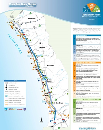
In response to the corridor constraints and deficiencies discussed above, SANDAG and Caltrans have identified a comprehensive corridor vision that includes a suite of multimodal solutions and community and resource enhancements projects that address the NCC's existing deficiencies and improve mobility, coastal access, quality of life, and natural resources. Figure 2 illustrates the suite of improvements proposed for the NCC.
Movement of People Rather than Vehicles
While population and travel are expected to increase over the next 40 years, the 2050 RTP focuses investment on facilities that encourage alternative modes of transportation–such as improving the existing LOSSAN rail corridor, introducing Express Lanes on I-5 that allow for express buses, bus rapid transit (BRT), and HOVs, and developing bicycle lanes, sidewalks, and trails. Collectively, proposed transportation improvements would reduce traffic congestion and encourage alternative modes of travel to SOVs, which would lead to more efficient use of fuel, reduced idling times, and corresponding energy and air pollution reductions. The PWP/TREP's investments in LOSSAN rail improvements, Express Lanes, transit services, and non-motorized travel directly contribute to regional GHG reduction objectives and are key components of SANDAG's overall strategy to achieve compliance with the mandates of California Senate Bill 375.
In addition to addressing traditional mobility goals, these types of improvements concentrate future growth into identified Smart Growth and other urban areas where corresponding travel demand can be accommodated by a combination of these alternative modes of transportation. These effects could contribute to economic growth by allowing time and money previously spent on travel to be used for other purposes, by attracting businesses and residents to places with increased accessibility and improved quality of life, and by reducing overall costs to society. These improvements also inherently serve to minimize energy consumption and air emissions, while protecting, promoting and enhancing a variety of public access and recreational resources in the corridor as mandated by the Coastal Act.
Many modal alternatives have been studied over the last 20 years. The mix of transportation improvements proposed in the PWP/TREP provides the most mobility, more efficiently, and with minimal facility expansion (footprint) when compared to other transportation alternatives that have been studied.
LOSSAN Rail and Transit Improvements
The LOSSAN rail corridor is part of the most heavily traveled rail corridor in the country. The PWP/TREP makes a $2.2 billion investment in rail and transit improvements to make travel by transit faster and more accessible. The LOSSAN rail program in the NCC includes several double-tracking projects ranging in length from 0.6 to 2.7 miles (totaling approximately 10 miles of new track). More than any other rail improvement, this would do the most to increase capacity, increase reliability, and reduce travel time.
Beyond double-tracking, many other infrastructure enhancements are planned for the LOSSAN rail corridor. The installation of various stub tracks, layover tracks, and track crossovers would improve operations for all four rail operators (COASTER, Amtrak, Metrolink, and BNSF) in the corridor. Like double-tracking, these projects would increase capacity and decrease conflicts, which would result in better reliability and shortened travel times. In addition, the program features enhanced pedestrian crossings, vehicle crossing improvements, and rail bridge replacements to improve safety and accessibility. Beyond track improvements, the LOSSAN projects also include station and parking enhancements, within, adjacent to, or in close proximity to existing stations, that will increase access to rail services for current and potential riders at each of the 6 NCC stations. There are also eight grade separations (three local roads and five bicycle/pedestrian facilities) planned that will increase the safety and performance of both the LOSSAN corridor and the facilities that cross it. Finally, a tunnel is planned that would move the rail alignment away from the fragile Del Mar bluffs, which cannot be double-tracked because of structural and environmental concerns. The planned LOSSAN rail corridor enhancements would allow for much greater capacity on the rail corridor than is needed today, ensuring that the rail infrastructure would be able to accommodate demand growth for many decades.
Additional transit improvements planned for the NCC and supported by the PWP/TREP transportation infrastructure improvements include the enhancements to local bus service along Coast Highway to provide higher-speed, limited-stop service to the Coast Highway arterial road that runs the length of the corridor. Additionally, the Mid-City to Palomar Airport Road BRT service, which is planned to operate in the I-5 Express Lanes (discussed below), is a "reverse commute" service that would connect San Diego's Mid-City residential neighborhoods to employment centers in Carlsbad.
I-5 Highway and Related Improvements
I-5 has gone more than 40 years without major capacity improvements. To keep up with evolving transportation options, the freeway must be improved to accommodate efficient HOV use and lessen travel times. The primary I-5 improvements in the NCC include the addition of two Express Lanes in each direction beginning at La Jolla Village Drive in San Diego and extending northward approximately 27 miles to Harbor Drive in Oceanside. These lanes would maximize the person-carrying capacity of the highway by prioritizing HOVs such as carpools, vanpools, and transit buses, with SOVs allowed to enter the lanes (for a fee) only when excess capacity exists. During peak conditions, one Express Lane is able to carry nearly 70% more people than one general-purpose lane. Express Lanes would accommodate future demand on I-5 by getting the most person-carrying capacity out of the least amount of highway footprint expansion, thereby reducing overall congestion on I-5 for all users, protecting and facilitating public access, and minimizing impacts to adjacent communities and sensitive coastal resources. The proposed Express Lanes would result in the following:
- A reduction of 25-35% in peak-period corridor travel times on I-5
- A reduction of 4% in VHT on I-5
- A reduction of 47% in VHD on I-5
- Reductions of 17% and 10% in VMT on Coast Highway and El Camino Real, respectively
- Reductions of 12% and 3% in ADT on Coast Highway and El Camino Real, respectively
- A decrease in the duration of daily peak-period congestion on I-5 from a range of 12 to 13 hours to a range of 5 to 6 hours.
In addition, the Express Lanes would also serve as an essential enabler of public transportation, by giving priority to buses and other HOVs. Express Lanes make public transit possible and attractive because this new infrastructure would support reliable, congestion-free trips, allowing I-5 to accommodate transit services such as express buses and BRT in the future as demand increases, further reducing congestion on I-5 and local arterials. The ability to manage these new highway lanes to meet changing travel behavior and demand–by variable pricing when capacity allows, changing vehicle occupancy requirements, or even creating a truck route during certain times of day– guarantees that there would always be free-flow access to coastal resources and communities.
Beyond the Express Lanes, several other highway-related improvements are planned including improvements to the I-5/SR 56 and I-5/SR 78 interchanges to provide better connectivity with adjacent facilities. Additionally, most over- and under-crossings of local streets will be replaced or widened, and new bridge structures will be built in several locations to improve multimodal connectivity between east and west sides of the highway. New auxiliary lanes are also planned in several locations, which would allow for greater capacity and safety on the highway by providing additional space for weaving, merging, and acceleration. Finally, the highway would benefit from the installation of several Intelligent Transportation System elements, including fiber-optic cable, changeable message signs, highway advisory radio channels, ramp meters, and vehicle detection systems. Additionally park-and-ride facilities in the corridor would be provided with charging-station infrastructure to support "zero-emission" vehicles.
Strategies to Minimize Highway Expansion
SANDAG and Caltrans understand that the region cannot build its way out of congestion and therefore have adopted several strategies to focus on managing demand. Population and travel demand will continue to grow in the NCC with or without highway or transit improvements, and SANDAG's goal is to accommodate the growth in the most efficient way possible, minimizing costs as well as environmental impacts.
In the absence of major highway expansion in the corridor, the region has focused on a variety of strategies that work together to manage the growth in demand and address the multiple needs of travelers. Without these ongoing strategies, many more freeway lanes than currently planned would be required to meet future forecasted travel demand. Instead, the ongoing and future approach includes the following major components:
-
Transportation Demand Management (TDM)
Strategies have been and would continue to be an important method to reduce travel demand in the corridor by encouraging the use of the bus, carpooling, and other alternative modes. TDM strategies take advantage of (and help build a customer base for) alternative modes by removing obstacles and providing information and incentives to travelers to make it easy for them to reduce trips, reduce travel at the most congested times, or shift altogether from SOV driving.
On a regional level, SANDAG implements TDM through its iCommute program. The program assists commuters by providing free carpool and ride-matching services, a subsidized vanpool program, transit solutions, regional support for bicycling, the Guaranteed Ride Home program for regular transit commuters, and the SchoolPool carpooling program for parents. iCommute also provides free assistance to local businesses, helping them develop and implement customized employee commuter benefit programs that lower costs, increase productivity, and help the environment. In addition to the regionwide emphasis of the iCommute program, the 2050 RTP also requires the development of corridor-specific TDM plans to address the varied needs and demands of the region's distinct corridors and communities. Together, SANDAG and Caltrans have developed a comprehensive TDM plan for the NCC that seeks to 1) manage congestion during construction of NCC rail, transit-highway, and roadway projects; and 2) act as a foundation for continued travel behavior changes in the corridor once construction is complete. The first phase in development of this plan was extensive market research and analysis of existing conditions– including all trip markets–through surveys and interviews of employers, commuters, schools, cities, and major institutions to identify the best opportunities for TDM programs and services in the corridor. Based on the market research, TDM measures and strategies were developed for the NCC and were tailored to reflect the propensity of NCC residents, commuters, and others to shift their modes of travel from SOV to non-SOV alternatives such as transit, walking, cycling, carpooling/vanpooling and teleworking. Implementation strategies include programs and services geared toward employers, agencies, schools and commuters, financial incentives to encourage alternative travel behavior, public outreach to corridor residents and institutions, and performance monitoring to measure the program's effectiveness.
-
Transportation Systems Management (TSM) and Operational Improvements
TSM is a strategy to increase highway capacity without major capital investment, by enacting various operational improvements that increase system efficiency. These include the construction of new auxiliary lanes on the outside of the freeway that would connect on- and off-ramps and allow for acceleration, deceleration, and merging–often the causes of traffic bottlenecks and congestion. Other improvements include Intelligent Transportation System (ITS) features (such as variable message signs) that provide real-time information for drivers to make informed decisions on travel routes and corridor-wide ramp meters at highway entrances to help regulate the flow of incoming traffic. Various corridor interchange improvements help eliminate or minimize bottlenecks in the transportation system. Additional detection, monitoring, and communications infrastructure would allow for incident response and active management of the highway.
Enhancing Coastal Access
The Coastal Act recognizes the necessity and benefit of providing varied transportation choices for all people, including alternative transportation modes that are not reliant on the automobile. These choices include not only transit but also active transportation modes such as walking and biking. Well-planned, non-motorized transportation networks can bridge the gap between origins or destinations and the transit system, facilitating more transit use. In addition, pedestrian and bicycle facilities create attractive transportation links between land uses that draw travelers out of their automobiles when making short, local trips and when seeking access to coastal resources. Providing pedestrian and bicycle access to the shoreline and upland recreation areas is one of the highest priorities of the Coastal Act.
In addition, the Coastal Commission Public Access Action Plan recognizes roadway congestion as one of the greatest impediments to public access in coastal areas and specifically notes that, among other things, traffic congestion and poor traffic circulation are significant problems where residents and visitors compete to use the same transportation system.
The presence of adequate parking facilities in coastal areas to serve residents, commercial uses, and visitors who travel by car is another important variable that influences public access and recreation opportunities in the Coastal Zone. Transit services must be supported by ample parking, walking, and bicycle facilities in order to ensure maximum accessibility of the NCC's coastal resources via alternative modes of travel.
In support of these objectives, the PWP/TREP proposes a number of improvements designed to improve coastal access by reducing traffic congestion and providing travelers new transportation options. These improvements would be integrated or implemented concurrently with the highway and rail projects and would effectively eliminate east-west bicycle and pedestrian barriers along the I-5 highway and LOSSAN rail corridors. Coastal access improvements in the PWP/TREP include the following:
- Improving bicycle and pedestrian network east-west connectivity by providing links to the region's major bicycle facilities–including the Coastal Rail Trail as well as the future I-5 North Coast Bike Trail in the NCC.
- Reducing traffic congestion on I-5 to alleviate the pressure on local communities to address and accommodate "cut-through" traffic on Coast Highway and other arterial streets that may otherwise be affected as highway travelers search for alternate routes.
- Improving public transportation infrastructure to support more frequent, attractive, and reliable rail, BRT and rapid bus service, resulting in increased transit ridership and reduced traffic congestion that would otherwise adversely affect the ability of the public to reach the coast along this primary coastal access corridor.
- Improving and integrating transit services with other non-automobile modes of travel within the corridor to increase ridership and reduce traffic congestion that would otherwise adversely affect public coastal access.
- Constructing several missing links of the Coastal Rail Trail within, adjacent to, or in close proximity to the LOSSAN rail corridor right-of-way. These projects would construct more than 7 miles of the Coastal Rail Trail in the cities of Encinitas and Carlsbad.
- Constructing a new facility–the I-5 North Coast Bike Trail–running the entire length of the corridor roughly parallel to the highway that would complement the existing Coast Highway, Coastal Rail Trail, and the Coastal Trail. The trail would consist of separated and shared bicycle facilities and would be located partially in the Caltrans right-of-way (adjacent to I-5) and partially on adjacent city right-of-way. These would link communities and provide access across lagoons.
- Enhancing and providing bike and trail staging areas, including support facilities such as parking, which would be distributed throughout the corridor.
- Creating and enhancing pedestrian access to other natural resources, including lagoons and adjacent upland areas via trail and bicycle improvements throughout the corridor.
- Providing new or enhanced pedestrian and bicycle connectivity at freeway interchanges.
- Expanding parking areas at, adjacent to, or in close proximity to the corridor's transit stations, which would support passenger rail service and reduce the possibility of conflicts between rail passenger and coastal access parking resources on adjacent streets.
- Constructing four Express Lanes to provide a congestion-free facility for visitors and families on the weekend.
Preserving and Enhancing Community & Coastal Character
Community Enhancement Program
Caltrans and SANDAG have coordinated with the NCC's communities to identify community enhancement opportunities that would benefit from simultaneous construction and improve how the LOSSAN rail and I-5 highway projects interface with adjacent communities. The community enhancement projects were identified and developed in close coordination with affected communities and included coordinating project development team meetings, developing preliminary design concepts, meeting with city officials and staff, and developing the I-5 NCC Project Design Guidelines.
The PWP/TREP includes a package of 33 additional community enhancements that would create new trails and trail connections, open space parks, community gardens, and park-and-ride facilities in or near the I-5 highway right-of-way. Enhancements would also include widened sidewalks, bike lanes, street trees, slope and parkway plantings, enhanced pedestrian crossings, and other amenities intended to enhance the visual experience for pedestrians and bicyclists. These improvements would protect and enhance coastal community character, while improving travel choices by creating and completing linkages between communities, inland and coastal areas, and enhancing access opportunities to the corridor's regionally significant natural resource and recreation areas.
Preserving and Enhancing Community and Coastal Character
The PWP/TREP provides unique opportunities to preserve the coastal character of the corridor, which is largely defined by the natural open space areas associated with the NCC lagoons. The PWP/TREP includes acquiring, preserving, and restoring lands within and adjacent to the lagoon systems, resulting in the parallel benefits of preserving visual open space for public enjoyment and protecting and enhancing natural resources. The PWP/TREP bicycle and pedestrian trail improvements would further provide new opportunities for public access to the NCC's significant open space areas for passive recreation and extensive coastal resource viewing opportunities, including views to and along the coastline and within the corridor's large open space and natural resource areas. In this regard, the PWP/TREP would contribute to and expand the corridor's visual open space resources, while providing continuous public viewing opportunities of the corridor's most significant natural features.
In addition, Caltrans has worked with the NCC communities to develop a set of design guidelines, which are included as Appendix C to the PWP/TREP. The I-5 NCC Project Design Guidelines include corridor-wide and local design themes to preserve the natural and community visual characteristics of the existing corridor and create a unifying visual thread. These guidelines protect coastal views, incorporate community and regional identity into architectural features, and implement a conversion of existing ornamental freeway landscaping to sustainable, non-invasive native planting.
Preserving, Restoring and Enhancing Sensitive Coastal Habitat
The NCC is recognized for its varied, unique, and significant marine and environmentally sensitive resource areas. The coastal watersheds, lagoons, and upland areas in the corridor consist of a range of diverse habitats and ecosystems that support a variety of plant and wildlife species. The region's natural resources warrant protection and enhancement in light of increasing population demands and development pressures to ensure long-term viability of natural resources in accordance with regional sustainability measures.
Consistent, comprehensive, and proactive resource planning and management is necessary to effectively restore and preserve habitat areas throughout the NCC. Such an approach addresses individual project-specific habitat impacts at the local level, as well as corridor- and regionwide cumulative resource impacts. The PWP/TREP provides a coordinated, strategic, and comprehensive program for mitigation that will exceed the value provided by traditional and often fragmented project-specific mitigation. The PWP/TREP commits significant resources to preserving, restoring, or establishing hundreds of acres of sensitive coastal habitat in the NCC–to include 220 acres of wetland and upland mitigation, as well as the potential restoration of two lagoon systems covering over nearly 700 acres–ensuring a healthy future for the corridor's valuable coastal resources. This commitment is shown through the acquisition of transitional habitat and buffer areas and restoring habitat areas by purchasing land areas adjacent to corridor lagoons and by supporting comprehensive lagoon restoration that optimize transportation facility infrastructure improvements and fund major restoration efforts. These PWP/TREP commitments will help address the water quality and habitat needs of the NCC's special-status and wildlife species and will achieve the overall goal of enhancing biodiversity and habitat value throughout the corridor. Additionally the region has advanced a significant amount of local funds that allow for land acquisition, preservation, restoration, protection and enhancement in advance of the transportation-project impacts. This comprehensive approach to mitigating transportation impacts offers a rare opportunity to achieve large-scale, coordinated environmental benefits tailored to the specific needs and opportunities of the NCC.
Resource Enhancement and Mitigation Program (REMP)
The PWP/TREP includes the REMP (described in more detail in Chapter 6B) as part of the phased implementation plan for transportation improvements. The REMP provides for mitigation planning and implementation through the NCC PWP/TREP process to effectively mitigate project impacts in a manner that addresses regionally significant resource enhancement and preservation needs. The REMP includes the following mitigation activities: strategic acquisition of habitat parcels that protect and enhance NCC lagoon system and watershed functions and services and meet no net loss requirements through establishment and restoration; acquisition, preservation and potential enhancement of parcels that contribute to regionally significant resources, including upland habitat areas; planning and implementing regionally significant lagoon restoration projects; providing long-term non-wasting endowments for two regionally significant lagoons to fill funding gaps for maintenance and management activities; and funding a Scientific Advisory Committee to provide technical support for the design, implementation, and monitoring of these REMP activities.
Water Quality
The NCC PWP/TREP would implement a comprehensive, corridor-wide program to restore water quality and wetland habitat. The PWP/TREP would maximize the treatment of surface water runoff through existing surfaces and new impermeable surfaces, incorporation of storm-water Best Management Practices (BMPs) within the project footprint, and reducing the pollutant burden in storm-water runoff along I-5. The program analyzes the entirety of the corridor from a water quality perspective in relation to the impaired receiving water bodies in the NCC and provides for a more comprehensive approach to analyzing the hydrology of the entire project area for purposes of improving water quality. The proposed PWP/TREP improvements would implement treatment BMPs for both the new and existing impervious pavement as each portion of the corridor project is designed to meet all the requirements of the Project Planning and Design Guide including implementing LID, Design Pollution Prevention, construction and approved treatment BMPs. The project will be in compliance with the 2013 Caltrans Statewide Storm Water Permit issued by the State Water Resources Control Board. To further support water quality treatment within the corridor, Caltrans would implement a pilot program to assess the use of porous pavement at the park-and-ride at the San Elijo Multi-Use Facility (near Manchester Avenue) and enhanced vista point within the San Elijo Lagoon watershed. The functionality of the porous pavement at these locations would be assessed to help determine the feasibility of its use at other highway-owned facilities in the corridor.
Capital improvement activities that improve hydraulic functions in lagoon systems are another critical enhancement feature proposed in the PWP/TREP. With the guidance from a number of resource agencies, SANDAG and Caltrans conducted optimization studies for the corridor's lagoons to ensure that the design of bridge crossings maximizes hydraulic functions, minimizes fill, improves wildlife connectivity and improves tidal circulation in the corridor's lagoon systems. These improvements at currently constrained bridge crossings would significantly improve water quality and the ecological value of the lagoons and adjacent areas to better support ESHAs, special-status species, and wildlife. Lengthened bridges and reduced footprints from structural supports would restore water and tidal circulation of lagoons, improve conveyance of streamflow and sediment transport from inland areas, facilitate passage of fish and other aquatic species, and restore natural shoreline processes, thereby enhancing the biological productivity of marine resources. In total, three of the I-5 bridges (San Elijo, Batiquitos, and Buena Vista Lagoons) and the San Elijo Lagoon LOSSAN Bridge would be lengthened to improve tidal flows.
Coastal Development and Resources - Chapter 5
The PWP/TREP evaluates the NCC improvements for consistency with applicable coastal development policies of the Coastal Act, and where applicable, LCP policies for each affected, certified city in the NCC. The policy consistency assessment builds on the discussion of identified mobility and resource deficiencies, and the vision and goals for the corridor, since these issues directly relate to potential coastal resource concerns and opportunities presented by the following scope of improvements:
- Energy Conservation and Emissions Reduction
- Promotion of Public Transit and Smart Growth
- Public Access and Recreation
- Marine Resources: Water Quality and Wetlands
- Environmentally Sensitive Habitat Areas (ESHAs) and Special-Status Species
- Archaeological and Paleontological Resources
- Coastal Visual Resources
- Site Stability and Management
- Agricultural Resources
Each of the Coastal Act issue area sections addressed in the PWP/TREP includes a setting description of existing coastal resources in the NCC that could be affected by the scope of improvements. A discussion of potential coastal resource concerns, developed in consultation with Coastal Commission staff as general guidance in identifying potential resource issues to help frame the PWP/TREP impact analysis is also provided, which is followed by an impact analysis for the proposed rail and highway corridor improvements. The resource area impact analyses reflect those discussions contained within the LOSSAN Final Program EIR/EIS (September 2007) and the I-5 NCC Project Final EIR/EIS (October 2013), where applicable. The PWP/TREP further identifies resource opportunities and benefits presented by the scope of improvements followed by a series of Policies, Design/Development Strategies and Implementation Measures for the proposed PWP/TREP improvements.
The Coastal Act consistency analysis lists Coastal Act policy directives addressed in the PWP/TREP and evaluates proposed rail and highway corridor improvements for consistency with the applicable policy requirements, including in the context of the Coastal Act directive to resolve potential Coastal Act policy conflicts in a manner that, on balance, is the most protective of significant coastal resources. The PWP/TREP also provides a consistency analysis with LCP policies for each certified city in the corridor affected by the scope of highway and community enhancement improvements, and includes a preliminary assessment of where specific LCP policies present potential conflicts for the improvements that could require amendment of the certified LCPs to ensure consistency.
Project Implementation - Chapter 6
The PWP/TREP provides the Implementation Framework and Phasing Plan for rail, highway, community and resource enhancement improvements to ensure that a balanced, multimodal solution for the corridor's transportation needs is implemented in conjunction with community enhancement and natural resource restoration plans. The PWP/TREP phasing plan coordinates the timing of LOSSAN rail, I-5 highway, and community- and resource-enhancement project components to ensure highway projects do not outpace other multimodal transportation improvements for the corridor, and that proposed transportation projects do not outpace natural resource restoration and enhancement. The implementation framework considers a range of priorities, constraints, and other factors that shape the baseline phasing plan, which includes the following:
- Available revenue and project cost (both capital and operations)
- Regional growth and transportation need
- Transportation system performance
- Minimization of construction impacts to the public and the environment
- Requirements of SB 468
- Safety and rehabilitation needs
- Coastal access and promotion of alternative modes
- Ensuring the most valuable, high quality mitigation opportunities in the NCC are identified, secured, and prioritized for implementation
The PWP/TREP also includes a comprehensive monitoring and reporting requirement over the life of the program to track progress toward meeting the goals outlined in the PWP/TREP and phasing plan. The indicators used in ongoing monitoring have been selected to illustrate those areas in which the region appears to be moving in the right direction and those in which improvement is needed. The indicators provide stakeholders with assurances that the program is being implemented in a timely and balanced manner, and also serve to assess if requested project-specific scope or schedule changes to future improvements in the program are consistent with commitments made in the PWP/TREP.
Reporting on the performance of PWP/TREP implementation recognizes that the success of the improvements go beyond the initial capital investment and assess how the capital investment made in the corridor has resulted in tangible improvements to PWP/TREP objectives. The PWP/TREP includes a Transportation Report Package to be submitted every four years in order to provide detail on improvements to the entire transportation system located within the NCC. The Transportation Report Package would include updates on capital improvements, an accounting of dollars invested, changes in transportation trends, and information on other transportation strategies implemented through the corridor. In particular, the report will provide an overall picture of the progress made during the past four years toward meeting the 40-year transportation goals expressed within regional plans and the PWP/TREP, and will be presented to the Coastal Commission as an informational item.
Conclusion and Next Steps
California Coastal Act Policy Conflict Resolution
Though carefully planned and designed, the PWP/TREP acknowledges that proposed mobility improvements would result in impacts to wetlands, ESHAs, and agricultural resources. However, balanced against the coastal resource impacts of the PWP/TREP improvements is the competing fact that denying or modifying the PWP/TREP to eliminate these impacts would create a conflict with Coastal Act policies that mandate protection of coastal resources by 1) minimizing energy consumption and vehicle miles traveled and protecting air quality; 2) concentrating new development in or adjacent to areas able to accommodate growth; 3) providing and enhancing transit and non-automobile circulation, and ensuring that the potential for public transit is provided for high-intensity uses; and 4) protecting and enhancing public access to the coast and enhancing shoreline and upland recreation areas in the Coastal Zone.
Without the proposed PWP/TREP improvements, continued degradation of regional mobility and coastal public access and natural resources would occur. As with most other significantly populated coastal communities in California, unmet transportation demand results in conflicts between community residents, commuters, and visitors competing for limited capacity on existing transportation systems for various uses. The PWP/TREP improvements would implement a multimodal transportation system– providing safe and reliable access within and beyond the NCC to coastal-dependent industry and shoreline and upland recreation areas in the corridor–and would thereby affirmatively implement Coastal Act policies that require maximum protection and enhancement of coastal access and recreation. The PWP/TREP would improve public transit and non-motorized transportation alternatives that reduce energy consumption and air emissions, resulting in improved air quality and supporting Smart Growth efforts to sustainably accommodate future growth in the corridor. In addition, although PWP/TREP improvements would result in impacts to wetlands and ESHAs, the impacts would be minimized and mitigated with a REMP that would both offset impacts and substantially enhance water quality, wetlands, and sensitive resources in the corridor as compared to existing conditions.
Accordingly, the PWP/TREP is the approach that, on balance, is the most protective of significant coastal resources.
Next Steps
The PWP/TREP is the result of more than 10 years of collaboration and public input about how to comprehensively improve the NCC. The Preliminary Draft PWP/TREP, first released to the public in June 2010, was updated to reflect input from the public, local cities, resource agencies, and the Coastal Commission. Release of the Updated Draft PWP/TREP in March 2013 initiated the public review and comment period on the PWP/TREP, which continues throughout the Coastal Commission review process. The draft document was distributed for initial public review and comment for 60 days, during which time it was presented at two public workshops to solicit feedback and to answer questions. The Updated Draft PWP/TREP was revised based on comments received during the comment period and resubmitted to the Coastal Commission for formal consideration and conduct of additional environmental analysis pursuant to its certified regulatory program under the California Environmental Quality Act (CEQA) in November 2013. Since that time, additional revisions and updates were made to reflect new or additional input received from the public, local cities, resource agencies, and the Coastal Commission, with the Final PWP/TREP provided to the Coastal Commission for further consideration in June 2014. Members of the public are invited to review and provide comments on how the Final PWP/TREP affects coastal access and other coastal resources in the corridor, which will be considered by the Coastal Commission for consistency with applicable LCPs and the Coastal Act at a local, public hearing, anticipated to be held in late summer/early fall 2014.