
Section 6B – Resource Enhancement and Mitigation
6B.1 Introduction
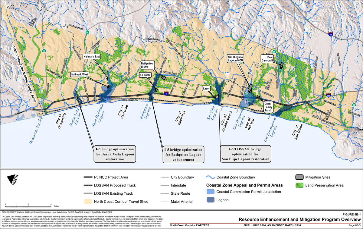
The North Coast Corridor (NCC) includes approximately 30 miles of coastline that is recognized for a number of unique and significant marine and environmentally sensitive habitat areas (ESHA). The Public Works Plan (PWP)/Transportation Restoration Enhancement Program (TREP) planning area has been delineated as the Coastal Zone boundary to the east with the Pacific Ocean as the western boundary, and extending from La Jolla Village Drive in San Diego as the southern boundary to Harbor Drive in Oceanside/Camp Pendleton Marine Corps Base as the northern boundary (Figure 6B-1). The coastal watersheds, lagoons, and upland areas in the corridor provide a range of diverse habitats and ecosystems that support a variety of plant and wildlife species. Due to the location of the proposed PWP/TREP improvements, the sensitive habitats traversed by the planned corridor improvements, and the sensitive species living along the corridors, all impacts to coastal resources cannot be avoided. The San Diego Association of Governments (SANDAG) and the California Department of Transportation (Caltrans) have coordinated with the regulatory and resource agencies for many years through the I-5 NCC environmental review processes, as well as applicable permit processes for each agency with jurisdictional oversight over resources within the PWP/TREP planning area. The PWP/TREP Resource Enhancement and Mitigation Program (REMP) has been developed to identify compensatory mitigation opportunities to address these unavoidable impacts and to implement projects that benefit existing natural resources, which exceed standard ratio-based compensatory mitigation programs. The PWP/TREP planning area has been defined as the Service Area for compensatory mitigation opportunities needed to offset impacts associated with approved PWP/TREP transportation infrastructure and community enhancement projects.1
6B.1.1 Definitions
Compensatory mitigation is defined by the U.S. Army Corps of Engineers (USACE) and the U.S. Environmental Protection Agency (EPA) as the "restoration (re-establishment or rehabilitation), establishment (creation), enhancement, and/or in certain circumstances preservation of aquatic resources for the purposes of offsetting unavoidable adverse impacts which remain after all appropriate and practicable avoidance and minimization has been achieved" (2008).
Throughout this chapter, the term "enhancement" serves different purposes as it pertains to the regulatory needs of the California Coastal Commission (Coastal Commission) and the USACE. In regards to the Coastal Commission process, enhancement is used in a broad sense akin to resource improvement or benefit. This includes compensatory mitigation projects that would result in varying levels of functional lift to the coastal resources located within the NCC and includes large-scale lagoon-enhancement restoration projects, endowments for lagoon inlet maintenance, and preservation of high-quality habitat from the threat of future development.
The following terms are used throughout the chapter but are defined differently for the USACE:
- Wetlands for the Coastal Commission is defined as land where the water table is at, near, or above the land surface long enough to promote the formation of hydric soils or to support the growth of hydrophytes and includes those types of wetlands where vegetation is lacking and soil is poorly developed or lacking as a result of frequent and drastic fluctuations of surface water levels, wave action, water flow, turbidity or high concentration of salts or other substances in the substrate. The upland limit of a wetland is defined as
- A) the boundary between land with predominantly hydrophytic cover and land with predominantly mesophytic or xerophytic cover,
- B) the boundary between soil that is predominantly hydric and soil that is predominantly non-hydric, or
- C) in the case of wetlands without vegetation or soils, the boundary between land this is flooded or saturated at some time during years of normal precipitation, and land that is not.
For the purposes of the USACE and EPA, the following definitions of compensatory mitigation approaches are being utilized in the REMP:
- Establishment (creation): Manipulation of the physical, chemical, or biological characteristics present to develop an aquatic resource that did not previously exist at an upland site. Establishment results in an increase in aquatic resource area and functions.
- Restoration: For the purpose of tracking net gains in the aquatic resource area, restoration is divided into two categories:
- Re-establishment: Manipulation of the physical, chemical, or biological characteristics of a site with the goal of returning natural/historic functions to a former aquatic resource. Reestablishment results in rebuilding a former aquatic resource and results in an increase in aquatic resource areas and functions.
- Rehabilitation: Manipulation of the physical, chemical, or biological characteristics of a site with the goal of repairing the natural/historic functions to a degraded aquatic resource. Rehabilitation results in an increase in aquatic resource function but does not result in an increase in the aquatic resource area.
- Enhancement: Manipulation of the physical, chemical, or biological characteristics of an aquatic resource to heighten, intensify, or improve a specific aquatic resource function(s). Enhancement results in the gain of selected aquatic resource function(s), but may also lead to a decline in other aquatic resource function(s). Enhancement does not result in an increase in the aquatic resource area.
For other resource agencies, the following definitions apply for upland habitat mitigation:
- Establishment in uplands is the manipulation of the physical, chemical, or biological characteristics of a site with no existing native habitat to create native habitat. This generally requires grading and planting or could be extensive clearing, removal of thatch, weeding, and planting.
- Restoration is the manipulation of the physical, chemical, or biological characteristics of degraded upland habitats to a native habitat through extensive clearing, exotic control, and planting.
- Enhancement is the manipulation of the physical, chemical, or biological characteristics that result in improvements to degraded native habitats through weeding and some seeding.
The proposed REMP employs a combination of measures to mitigate coastal resource impacts resulting from the implementation of the PWP/TREP transportation infrastructure and community enhancement projects. The constrained, primarily built-out condition of the NCC leaves few opportunities for land acquisition typically necessary to implement traditional, ratio-based compensatory mitigation. However, the NCC is home to six major lagoon systems, which represent some of southern California's most significant natural resource areas. These lagoon systems, associated upland habitat, and riparian wetland interface and their contributing watersheds provide large, contiguous areas that support sensitive habitats for a variety of plant and wildlife species, and that provide water quality, flood control, groundwater recharge, and recreational benefits. The NCC's lagoon systems and their habitats are biologically unique and cannot be replicated. As such, the REMP focuses on opportunities to protect the NCC's lagoon systems from potential future degradation and to expand, restore, and/or enhance habitat within these systems. This approach requires comprehensive solutions with efforts focused on ecosystem-wide enhancements, including preservation, restoration, and long-term management. The REMP approach to evaluating and implementing compensatory mitigation projects at the regional scale and in advance of PWP/TREP project impacts, and designing lagoon bridges to avoid and minimize project impacts, results in greater benefits to coastal resources throughout the corridor than if only ratio-based, and project- and site-specific compensatory mitigation were employed.
The REMP includes options for allocating funds from SANDAG's Environmental Mitigation Program (EMP) for a variety of regionally significant mitigation opportunities, including the establishment, restoration (re-establishment or rehabilitation), enhancement, preservation, and long-term management of coastal wetlands and adjacent riparian areas, other transitional habitats, and upland habitat areas. These mitigation activities include the following"
- Acquisition of habitat parcels for the REMP because of the sites' contribution to protecting and enhancing NCC lagoon system and watershed functions and services and meeting no net loss requirements through establishment and restoration
- Acquisition, preservation, and if necessary, enhancement, of parcels which contribute to regionally significant resources, including upland habitat areas
- Planning and implementation of regionally significant lagoon restoration projects
- Providing long-term non-wasting endowments for two regionally significant lagoons to fill funding gaps for maintenance and management activities
- Funding a Scientific Advisory Committee to provide technical support for the design, implementation, and monitoring of the suite of mitigation activities described in this REMP (see Figure 6B-1).
6B.1.2 Program Overview
For the Coastal Commission, the REMP provides for mitigation planning and implementation through the NCC PWP/TREP process to effectively mitigate PWP/TREP impacts in a manner that addresses regionally significant resource needs. For the USACE, the REMP is being utilized as a Planning Level
Compensatory Mitigation Plan for permitting individual projects within the NCC that are authorized to use one of the described compensatory mitigation sites. In addition, the REMP is being utilized to guide the development of detailed site-specific Habitat Mitigation and Monitoring Plans (HMMPs) for each of the compensatory mitigation sites in order to support permittee-responsible advance mitigation. For the U.S. Fish and Wildlife Service (USFWS), California Department of Fish and Wildlife (CDFW), National Marine Fisheries Service (NMFS), and the San Diego Regional Water Quality Control Board (RWQCB), the REMP is being utilized as the overall compensatory mitigation package for the covered projects. However, pursuant to each agency's jurisdictional authority and purview, agency-specific permits or consultations may result in additional requirements or procedures to be followed for project impacts and mitigation sites. Overall, the REMP provides the planning and implementation framework to ensure that the most valuable, high-quality compensatory mitigation opportunities in the NCC are identified, secured, and prioritized for implementation in a manner that cost-effectively utilizes available mitigation funding to maximize benefits to the natural resources with the NCC.
6B.1.3 Funding
The TransNet Extension Ordinance approved by the San Diego voters in November 2004 established an EMP for the advancement of mitigation for resource impacts associated with regional and local transportation projects. The REMP is structured to support the region's efforts to develop a comprehensive regional mitigation strategy utilizing the TransNet EMP, to be implemented as an integrated element of the PWP/TREP Implementation Plan and to be utilized by the resource and regulatory agencies in permitting transportation projects within the NCC. The REMP prioritizes expenditure of EMP funds on a corridor-wide level, with an emphasis on the establishment, restoration, enhancement, and preservation, and improving the ecological functions and services of sensitive NCC habitats in advance of impacts through funding systemwide restoration plans, endowments, and a Scientific Advisory Committee.
6B.1.4 Working Group
The PWP/TREP includes the formation of a REMP Working Group that would include SANDAG, Caltrans and resource and regulatory agency personnel directly involved in permitting of transportation projects, including but not limited to the USFWS, USACE, EPA, NMFS, CDFW, California Wildlife Conservation Board, RWQCB, Coastal Conservancy, and the Coastal Commission. The Working Group will provide oversight and advisory assistance for purposes of prioritizing compensatory mitigation timing and implementation, developing and reviewing of the site-specific HMMPs, and ensuring that specific REMP requirements are achieved. The Working Group will also prioritize and coordinate the disbursement of REMP funds for the San Elijo or Buena Vista Lagoon Restoration Projects. The Working Group may advise SANDAG and Caltrans on potential resource benefits of new compensatory mitigation opportunities that may be determined necessary as contingency measures and/or warranting consideration for incorporation into the REMP given their unique value. See Section 6B.9 for a detailed discussion of the REMP Working Group structure and responsibilities.
6B.2 Goals and Process Overview
6B.2.1 Goals
The overall goal of the REMP is to enhance and restore the biodiversity and habitat functions and services of critical ecological coastal resources within the NCC as compensatory mitigation in advance of unavoidable impacts associated with planned PWP/TREP transportation projects and community enhancement projects. This goal is being achieved through the following:
- The acquisition of habitat mitigation parcels for the PWP/TREP in consideration of the sites' contributions to protecting and enhancing the NCC lagoon system and watershed functions and services and meeting no net loss requirements through establishment and restoration.
- The acquisition, preservation, and if necessary, the enhancement of parcels that contribute to regionally significant resources, including upland habitat areas.
- Planning and implementation of regionally significant lagoon restoration projects.
- Providing long-term non-wasting endowments for two regionally significant lagoons to fill funding gaps for maintenance and management activities.
- Funding a Scientific Advisory Committee to provide technical support during the design, implementation, and monitoring of the suite of mitigation activities described in this REMP.
All compensatory mitigation sites include long-term non-wasting endowments to fund management in perpetuity. Funding for projects included within the REMP is directed to those sites identified as addressing the most critical ecological needs in the NCC while respecting the project phasing, the mitigation needs identified in the PWP/TREP, anticipated compensatory mitigation requirements by regulatory agencies, and the voter-adopted TransNet Expenditure Plan's EMP budget for the NCC. The resource mitigation program is intended to be flexible and adapt to future changes in opportunities while promoting mitigation in advance of impacts.
The opportunities identified within this REMP, including the early acquisition of sites containing high-value habitat for long-term preservation, will be phased ahead of or concurrent with unavoidable impacts from planned PWP/TREP transportation infrastructure and community enhancement projects. Implementing the REMP and individual compensatory mitigation sites in advance of unavoidable impacts will serve to reduce typically required mitigation ratios by reducing the uncertainty of location, type, and quantity of mitigation and reducing the temporal loss of habitat acreage, functions, and services from construction-related impacts. In addition, phasing transportation facility infrastructure at sensitive locations has been specifically designed to avoid and minimize impacts, protect existing lagoon system functions and services, and allow for future large-scale lagoon restoration projects.
6B.2.2 Stakeholder and Agency Participation
REMP opportunities and asset evaluations were identified and developed in coordination with various NCC natural resource stakeholders and resource and regulatory agencies. In consultation with these entities, SANDAG and Caltrans have identified several categories of mitigation opportunities (described in the following section), as well as a variety of resource protection options to address regionally significant needs. In some cases, the opportunity to implement site-specific compensatory mitigation efforts has already been secured via the land acquisition of suitable restoration sites.
In coordination with stakeholder groups and resource and regulatory agencies, SANDAG and Caltrans have identified two large-scale lagoon restoration and enhancement projects (San Elijo and Buena Vista lagoons) and one large-scale lagoon establishment project (San Dieguito W-19 property). Technical studies and environmental documents for these projects are being developed and the various stakeholder groups and resource and regulatory agencies are considering implementation of these projects, depending on the alternative chosen, for compensatory mitigation for the NCC transportation projects. SANDAG and Caltrans have been assisting through participation in project planning and provision of funds for technical and environmental studies. In coordination with resource and regulatory agencies, SANDAG and Caltrans funded hydraulic and sediment transport studies to analyze I-5 and Los Angeles–San Diego–San Luis Obispo (LOSSAN) bridge designs at the corridor lagoons to maximize avoidance and minimization of impacts, reduce tidal muting, and restore/improve wildlife movement. These optimized bridge designs in concert with expanded channel dimensions allow for the possible future establishment, restoration, and enhancement of tidal wetlands and improved water quality within the lagoons.
6B.2.3 Resource Impacts and Mitigation Opportunities
Table 6B-1 includes the total anticipated permanent impacts resulting from the NCC transportation infrastructure and community enhancement projects to be authorized by the PWP/TREP under the Coastal Act and other regulatory permit mechanisms, such as Clean Water Act Sections 401 and 404 and/or Rivers and Harbors Act Section 10 permit authorization. Table 6B-1 also includes a summary of the compensatory mitigation opportunities (and cost estimates) by type and acreage in order to satisfy regulatory agency permitting requirements. To ensure impacts can be adequately mitigated in advance and to provide contingency mitigation, the mitigation opportunities have been categorized into three "pools." Combined, these compensatory mitigation opportunities are expected to enhance regionally significant resources beyond traditional project-by-project ratio-based mitigation requirements. In addition, the REMP includes funding for the formation of an independent Scientific Advisory Committee made up of scientists charged with providing scientific-technical support through the design, implementation, and monitoring of the suite of compensatory mitigation activities described in the REMP.
6B.2.3.1 Temporary Impacts
Temporary impacts to natural resources (e.g., vegetation clearing, access road construction, staging, diversions, etc.) will occur to enable access and construction at PWP/TREP transportation infrastructure and community enhancement project sites. For purposes of adequately addressing potential temporary impacts, disturbances resulting in impacts to natural resources lasting more than 12 months are defined as long-term temporary impacts and must be mitigated beyond same-site restoration. An estimate of long-term temporary impacts associated with the implementation of the NCC infrastructure projects is provided in Table 6B-2. The LOSSAN temporary impacts are reflected within the permanent impact estimates for the rail improvements, based on the use of a conservative 50-foot-from-centerline footprint within the rail right-of-way.
Long-term temporary impact areas will be returned to pre-construction elevations and contours and revegetated with appropriate native species. Unless restricted due to weather, re-establishing elevations and contours should occur within one month following construction. Revegetation with native species will commence within three months after the restoration of preconstruction elevations and contours and be completed within one growing season. If revegetation cannot start due to seasonal considerations, exposed earth surfaces will be stabilized immediately with jute netting, straw matting, or other applicable best management practices to minimize any interim erosion. Restoration plans for all long-term temporary impact areas over 0.5 acres will be prepared for approval by resource and regulatory agencies.
Table 6B-1: PWP/TREP Project Impacts and Mitigation Opportunities Summary
Establishment (No Net Loss Pool)
Los Peñasquitos
- Deer Canyon II
- 14 Upland Habitat Acres Established
- $1,600,000.00 Cost Estimate (Including Right-of-Way & Construction Costs)
San Dieguito
- Dean Family Trust
- 20.8 Upland Habitat Acres Established
- $2,650,000.00 Cost Estimate (Including Right-of-Way & Construction Costs)
- San Dieguito W19
- 47.3 Coastal Wetland Acres Established
- 9.6 Upland Habitat Acres Established
- 19.8 Upland Habitat Acres Restored
- $48,600,000.00 Cost Estimate (Including Right-of-Way & Construction Costs)
Batiquitos
- Batiquitos Bluffs
- 2.5 Coastal Wetland Acres Restored
- 3.7 Upland Habitat Acres Restored
- Cost to be determined. Contingent upon a willing seller and reasonable cost.
Agua Hedionda
- Hallmark (East and West)
- 4.37 Coastal Wetland Acres Established
- 0.97 Coastal Wetland Acres Restored
- 3.5 Upland Habitat Acres Established
- 6.6 Upland Habitat Acres Restored
- $9,600,000.00 Cost Estimate (Including Right-of-Way & Construction Costs)
Corridor Wide Establishment (No Net Loss) Sub Total
- 51.67 Coastal Wetland Acres Established
- 3.47 Coastal Wetland Acres Restored
- 27.1 Upland Habitat Acres Established
- 50.9 Upland Habitat Acres Restored
- $62,450,000.00 Cost Estimate (Including Right-of-Way & Construction Costs)
Restoration, Enhancement & Preservation – "Enhancement" Pool
San Dieguito
- Dean Family Trust
- 1.5 Upland Habitat Acres Preserved/Enhanced
- Costs identified, above.
San Elijo
- Laser
- 0.02 Coastal Wetland Acres Preserved/Enhanced
- 4.1 Upland Habitat Acres Preserved/Enhanced
- $1,610,000.00 Cost Estimate (Including Right-of-Way & Construction Costs)
Batiquitos
- La Costa
- 18.8 Upland Habitat Acres Preserved/Enhanced
- $1,430,000.00 Cost Estimate (Including Right-of-Way & Construction Costs)
- Batiquitos Bluffs
- 39.9 Upland Habitat Acres Preserved/Enhanced
- Cost to be determined. Contingent upon a willing seller and reasonable cost.
Agua Hedionda
- Hallmark (East and West)
- 0.44 Coastal Wetland Acres Preserved/Enhanced
- 1.8 Upland Habitat Acres Preserved/Enhanced
- Costs identified, above.
San Elijo / Buena VistaLagoons Restoration Projects
- $90,000,000.00 Cost Estimate – Including Right-of-Way & Construction Costs (These restoration planning efforts are in process, and final cost estimates are not available at this time. However, it is acknowledged that at least one large-scale lagoon restoration project will be funded in full through the REMP).
Corridor Wide Preservation & Enhancement Sub Total
- 0.46 Coastal Wetland Acres Preserved/Enhanced
- 66.1 Upland Habitat Acres Preserved/Enhanced
- $93,040,000.00 Cost Estimate (Including Right-of-Way & Construction Costs)
Bridge Optimization
Batiquitos I-5 Bridge Lengthening
- Included for project avoidance and minimization purposes.
- $8,000,000.00 Cost Estimate (Including Right-of-Way & Construction Costs)
San Elijo I-5 Bridge Lengthening
- Included for project avoidance and minimization purposes.
- $16,000,000.00 Cost Estimate (Including Right-of-Way & Construction Costs)
San Elijo LOSSAN Bridge Lengthening (Assumes San Elijo Lagoon Restoration Project Alt 2A)
- Included for project avoidance and minimization purposes.
- $25,100,000.00 Cost Estimate (Including Right-of-Way & Construction Costs)
Buena Vista I-5 Bridge Lengthening
- Included for project avoidance and minimization purposes.
- $7,000,000.00 Cost Estimate (Including Right-of-Way & Construction Costs)
Bridge Optimization Sub Total
- $56,100,000.00 Cost Estimate (Including Right-of-Way & Construction Costs)
Lagoon Inlet Management Endowments – Contingency Pool
Regional Lagoon Maintenance Program
- Batiquitos – $9.50/ cy [est.]
- Peňasquitos – $3.90/ cy [actual]
- 20.7 Coastal Wetland Acres Established (Caltrans and SANDAG find that establishing an endowment should either be credited 20.7 acres based on hydraulic improvement and habitat creation as a result of maintaining the lagoon mouths at Batiquitos and Los Peňasquitos Lagoons, or it is understood that this endowment would address any potential no-net-loss deficits between credit release and when impacts would occur, as well as any temporal impacts).
- $10,000,000.00 Cost Estimate (Including Right-of-Way & Construction Costs)
Corridor Wide Lagoon Management Endowments Subtotal
- 20.7 Coastal Wetland Acres Established (Caltrans and SANDAG find that establishing an endowment should either be credited 20.7 acres based on hydraulic improvement and habitat creation as a result of maintaining the lagoon mouths at Batiquitos and Los Peňasquitos Lagoons, or it is understood that this endowment would address any potential no-net-loss deficits between credit release and when impacts would occur, as well as any temporal impacts).
- $10,000,000.00 Cost Estimate (Including Right-of-Way & Construction Costs)
Corridor-wide Project Impact vs. Habitat Establishment, Preservation, Enhancement & Lagoon Management Endowment Totals
- 72.37 Coastal Wetland Acres Established
- 3.47 Coastal Wetland Acres Restored
- 0.46 Coastal Wetland Acres Preserved/Enhanced
- 39.28 – 40.04 Total Impacts (LOSSAN & I-5) – Corridor-wide impacts identified for the I-5 Locally Preferred Alternative (8+4 with Buffer) combined with LOSSAN Project impacts. See Tables 6B-5 and 6B-6 for detailed project impacts by phase.
- 35.8 – 36.56 No-Net-Loss Wetland Balance (for purposes of Coastal Commission mitigation do not include preservation acreage).
- 27.1 Upland Habitat Acres Established
- 50.9 Upland Habitat Acres Restored
- 66.1 Upland Habitat Acres Preserved/Enhanced
- $165,490,000.00 Cost Estimate (Including Right-of-Way & Construction Costs)
Project Prioritization/Lagoon Management Technical Support
A REMP Working Group to include resource and regulatory agencies will be formed to evaluate, prioritize, and oversee the implementation of the potential compensatory mitigation sites identified in this REMP.
Scientific Advisory Committee
- Included to ensure mitigation site success.
- $1,000,000.00 Cost Estimate (Including Right-of-Way & Construction Costs)
Technical Support Subtotal
- $1,000,000.00 Cost Estimate (Including Right-of-Way & Construction Costs)
Table 6B-2: Long-term Temporary Impacts for I-5 NCC Improvements
| Habitat Type | Long-term Temporary Impacts* (acres) |
|---|---|
| Sensitive Upland Habitats | |
| Baccharis scrub | 0.14 |
| Baccharis scrub (disturbed) | 1.01 |
| Coastal sage scrub | 4.06 |
| Coastal sage scrub (disturbed) | 9.20 |
| Maritime succulent scrub | 0.22 |
| Native grassland | 0.15 |
| Southern maritime chaparral | 0.47 |
| Southern maritime chaparral (disturbed) | 1.37 |
| Total Temporary Upland Impacts | 16.62 |
| Wetland and Riparian Habitats | |
| Arundo scrub | 0.21 |
| Coastal brackish marsh | 0.58 |
| Coastal brackish marsh (disturbed) | 1.54 |
| Drainage ditch | 0.66 |
| Disturbed wetland | 0.73 |
| Freshwater marsh | 1.36 |
| Freshwater marsh (disturbed) | 0.38 |
| Mudflat | 0.44 |
| Mulefat scrub | 0.00 |
| Open water | 2.69 |
| Salt flat | 0.04 |
| Coastal salt marsh | 2.33 |
| Salt marsh transition | 0.21 |
| Southern willow scrub | 0.15 |
| Southern willow scrub (disturbed) | 1.38 |
| Southern willow scrub/freshwater marsh | 0.80 |
| Tidal riprap at bridge abutments | 0.03 |
| Waters of the U.S. (unvegetated channel) | 0.08 |
| Total Temporary Impacts to Aquatic Habitats | 13.59 |
Compensatory mitigation for these long-term temporary impacts to uplands would include either revegetation with native species of other nonnative habitat temporary impact areas (at a 1:1 ratio of replacement to impacts) or the preservation of high-quality native habitat under the threat of development (a 2:1 ratio of preservation to impacts). The suite of activities proposed in the "Enhancement Pool" listed previously in Table 6B-1 and described below, would be used to mitigate any additional compensatory mitigation requirements for long-term temporary impacts to wetlands and other aquatic habitats. Nearly all construction activities will require access and staging for greater than 12 months; therefore, most temporary impacts addressed through this REMP will be considered long-term temporary impacts. Short-term temporary impacts, or impacts lasting less than 12 months in duration that do not have significant impacts on native habitats or wildlife, will be restored to pre-existing conditions (contours and vegetated condition) immediately following construction.
The "Enhancement Pool" of opportunities includes large-scale habitat restoration and enhancement projects, as well as the preservation of high-quality upland habitats. The "Enhancement Pool" will mitigate for long-term temporary impacts by ensuring long-term protection of natural resources in advance of construction impacts at the regional (PWP/TREP project area) scale. See additional discussion in Section 6B.4.
Implementation of the REMP, as outlined in this NCC PWP/TREP, will also result in some temporary impacts to low-quality wetlands, such as disturbed wetlands and non‐tidal salt marsh, to re-establish, restore, and enhance high-quality tidal and freshwater wetlands. Any potential impacts resulting from the re-establishment, restoration, and enhancement will be identified in the site-specific HMMPs. No credit would be given and no additional mitigation would be required for these temporary impacts as long as there is a net benefit or a significant increase in quality and function of the reestablished/restored/enhanced wetlands. If any portion of the mitigation site fails to meet its success criteria under the HMMP, no credits would be released, and mitigation for temporary impacts may be required at that time.
6B.2.3.2 "No-Net-Loss Pool" – Establishment and Restoration (Re-establishment and Rehabilitation)
The No-Net-Loss Pool of opportunities includes compensatory mitigation sites that have a significant establishment and/or restoration components, and would generally result in a net gain in habitat area and/or functions and services. This net gain would directly offset permanent wetland and/or upland ESHA impacts at a 1:1 ratio, provided that the subject mitigation plans are implemented and performing at identified standards ahead of construction impacts associated with PWP/TREP transportation infrastructure and community enhancement projects.
For waters of the U.S., waters of the state, or other aquatic habitats, the establishment is the manipulation of the physical, chemical, or biological characteristics to create an aquatic resource that did not previously exist at an upland site resulting in an increase in aquatic resource area and functions. For both wetland and upland habitats, restoration involves the manipulation of the physical, chemical, or biological characteristics of a site with the goal of returning natural/historic functions to a former or degraded resource. Restoration efforts result in an increase in habitat function and habitat area. For the purpose of tracking net gains in the aquatic resource area, the USACE and the EPA divide restoration activities into two categories: re-establishment and rehabilitation.
Each establishment or restoration opportunity included in the REMP has a detailed Mitigation Site Assessment (MSA) that describes existing site conditions and potential opportunities for an establishment or significant restoration available on the site. MSAs can be located in Appendix H.
6B.2.3.3 "Contingency Pool" – Endowments and Restoration Infrastructure
The "Contingency Pool" of opportunities is provided to ensure that there is no mitigation (no-net-loss) deficits that could not be adequately addressed in advance of project impacts. Ideally, the Contingency Pool would not be required because impacts would be avoided by careful site planning, implementation, monitoring and management of the sites in the "No-Net-Loss Pool" and "Enhancement Pool." However, the Contingency Pool can be used for no-net-loss purposes to address any unforeseen circumstance, such as delays in achieving ecological performance standards at mitigation sites within the "No-Net-Loss Pool" or PWP/TREP project impacts occurring prior to release of adequate compensatory mitigation credits.
Lagoon Inlet Management Endowments. The REMP includes an endowment component that is intended to increase the capacity for long-term management of the Batiquitos and Los Peňasquitos Lagoons and support stewardship of these resources in perpetuity. This includes, but may not be limited to, funding for maintenance of lagoon inlets and channels deemed necessary to sustain tidal and fluvial flows and reduce sedimentation within these lagoon systems. To ensure that endowment funding is effectively managed, a Long-Term Management Plan indicating the ecological priorities and associated endowment contributions would be created, reviewed, and approved by the resource agencies and the lagoon manager. The Long-Term Management Plan would be created in association with the lagoon manager and be a living document, reflecting current conditions and needs of the lagoon ecosystem. Development of a Long-Term Management Plan for use of the funds at Batiquitos and Los Peñasquitos Lagoons would identify specific tasks covered by the proposed endowment, and would support establishment of long-term goals to ensure appropriate triggers (e.g., likely annually for Los Peňasquitos, every 3 years for Batiquitos, or imminent closure of the lagoon mouth) for when dredging activities would occur and funds would be released. Performance evaluation of the endowment would be evaluated at the end of the first phase of the PWP/TREP Implementation Phasing Plan (approximately 10 years) to ensure that adequate financial resources are in place to cover activities in perpetuity.
Absent the need for financial supplementation to ensure stability, the lagoon management endowments are to be considered supplemental to the enhancement component of the REMP. This endowment would not be applied to the other no-net-loss mitigation, enhancement, and preservation projects included in this REMP, as funding for those sites, already reflect a separate, site-specific long-term management endowment in their project costs.
Lagoon Restoration. As discussed previously, the REMP measures that contribute to large-scale lagoon restoration opportunities are considered a substantial mitigation element for all PWP/TREP project impacts. Enhancement efforts within San Elijo and/or Buena Vista Lagoons that may result in a change from current upland or freshwater dominated conditions to tidally influenced habitats may also be used for contingency mitigation, as necessary. Design alternatives for the environmental review of these large-scale lagoon restorations are ongoing, so specific acreage amounts are not presently available. The determination of acreage amounts for these potential future habitat changes that would qualify for contingency mitigation credit, as well as performance standards to measure and monitor the success of the restoration efforts, would occur pursuant to future Notice of Impending Development (NOID) or Coastal Development Permit (CDP) submittals and in discussions with the REMP Working Group. Other Contingency Opportunities. Modifications to Coast Highway, possibly including replacement of the culverts with a bridge or larger culverts, or other NCC transportation infrastructure currently representing a significant constraint to a lagoon system, could be considered by the Working Group in the future to offset potential no-net-loss deficits, as needed. However, these facilities are not within the LOSSAN or I-5 right-of-way and therefore are not included in the scope of PWP/TREP improvements.
6B.2.3.4 "Enhancement Pool" – Restoration, Enhancement, & Preservation
The preservation and Enhancement Pool of compensatory mitigation opportunities includes sites where permanent preservation of existing and/or potentially enhanced habitat can be achieved. It also includes large-scale lagoon restoration activities intended to improve corridor-wide lagoon system function and services and would serve to mitigate indirect impacts, temporal, and long-term temporary impacts resulting from PWP/TREP transportation infrastructure project and community enhancement project impacts, given the resulting benefits to wetland and other aquatic habitats and upland resources, water quality, tidal range, flood control, groundwater recharge, plant and wildlife habitat, and recreation. Habitat Preservation. Additional PWP/TREP project impact mitigation will be fulfilled by the acquisition of parcels containing high-quality upland ESHA, wetland or other aquatic resources, or parcels where enhancement of habitat can occur within the NCC Coastal Zone area, which can be permanently preserved. Habitat preservation would mitigate temporal resource losses and long-term temporary impacts resulting from PWP/TREP project impacts by ensuring the long-term preservation of upland ESHA, wetland, or other aquatic resources in advance of construction impacts occurring.
Lagoon Restoration. In recognition of the unique opportunities and value of comprehensive lagoon restoration activities for corridor lagoons, the REMP includes large-scale lagoon ecosystem restoration and enhancement mitigation opportunities, which will result in significant ecological lifts to the San Elijo Lagoon and/or Buena Vista Lagoon systems. The mitigation opportunity includes funding a large-scale lagoon restoration program in full for either San Elijo or Buena Vista Lagoons, which would be in addition to funds already contributed to previous and ongoing planning and technical evaluation activities necessary to facilitate and implement these lagoon restoration programs. Large-scale lagoon restoration in either San Elijo or Buena Vista Lagoons may include, but is not limited to, enhancement and restoration (both types) of wetland and other aquatic resources in the associated lagoons.
In the context of the regional lagoon systems of the NCC and their proximity to the ocean, the intent of the large-scale lagoon restoration funding is to improve the ecological health and hydrological connectivity and to enhance critical coastal resources and habitats. Potential San Elijo and Buena Vista Lagoons' restoration will be eligible for inclusion in the REMP, provided it results in a restored coastal wetland ecosystem that is in alignment with the regulatory agency and resource needs in the NCC (and impacts caused by the PWP/TREP transportation project improvements). The REMP measures that contribute to large-scale lagoon restoration opportunities, including funding and critical transportation infrastructure improvements, will be considered a substantial mitigation element for all PWP/TREP project impacts (including temporary long-term impacts) given the resulting wide range of benefits to sensitive habitat for plant and wildlife species, tidal range, water quality, flood control, groundwater recharge, and recreation.
6B.2.3.5 Bridge Optimization
Bridge optimization projects are specifically funded through capital expenditures and are designed to avoid and minimize project impacts and protect existing lagoon system functions and services. At several crossings, the optimized bridges will also allow for large-scale lagoon restoration projects that are needed as compensatory mitigation within the "Enhancement Pool." Bridge optimization projects involve lengthening lagoon bridges and expanding lagoon channel dimensions along the I-5 highway and LOSSAN rail corridors to improve existing tidal and fluvial flows, which will enhance wetland habitats, water quality within the lagoons, and wildlife movement.
6B.2.3.6 Lagoon Management Technical Support
Scientific Advisory Committee. The REMP provides funding for a Scientific Advisory Committee made up of independent scientists. The committee will provide technical advice, as necessary, regarding the design, implementation, and monitoring of mitigation projects described in this REMP. Funding for the committee would cover the time, expenses, and materials needed by scientists to complete their tasks. The committee will be directed by the REMP Working Group and will oversee the development or modification of ecological performance standards, monitoring methodology (techniques and timing), and actual monitoring of site performance. The REMP Working Group will recommend adaptive management measures to ensure site success and review monitoring reports, as necessary.
6B.3 Evaluation Framework
SANDAG and Caltrans have developed a suite of REMP evaluation classifications to assist in matching the various mitigation opportunities identified for the PWP/TREP with the type and/or level of impact and timing of implementation.
Table 6B-3 lists the proposed suite of mitigation opportunities and their associated REMP funding and capital costs. Table 6B-3 and Table 6B-4 aim to depict the differences in opportunities, exhibiting those that sustain a stronger nexus for meeting the most critical ecological needs while respecting the phasing requirements for transportation project development identified in the PWP/TREP, and greater feasibility and flexibility for timely resource mitigation project implementation.
The list below defines the criteria used to assess the various types of mitigation opportunities available to meet the needs of the PWP/TREP. The mitigation opportunity assets have been broken down into categories to clearly demarcate and define the suite of opportunities that are available to mitigate for the various types of impacts that are expected with the implementation of the PWP/TREP transportation infrastructure and community enhancement projects. Table 6B-4 lists each REMP opportunity by site name outlines the type of associated mitigation anticipated on-site and identifies the evaluated assets that are provided by that particular opportunity.
Table 6B-3: Mitigation Projects and Estimated Funding Allocations
| Mitigation Site | Funding (Millions $2012)1 | Capital Cost (Millions $2012) |
|---|---|---|
| No-Net-Loss Pool | ||
| San Dieguito W19 Restoration Site | $48.62 | – |
| Hallmark East and West Mitigation Site | $9.6 | – |
| Batiquitos Bluffs Mitigation Site | TBD3 | – |
| Dean Parcel Mitigation Site | $2.65 | – |
| Deer Canyon II Mitigation Site | $1.6 | – |
| Subtotal | $62.45 | – |
| Enhancement Pool | – | |
| Laser Parcel Preservation Site | $1.61 | – |
| La Costa Parcel Preservation Site | $1.43 | – |
| San Elijo Lagoon Restoration Project | $90.004 | – |
| Buena Vista Lagoon Restoration Project | – | |
| Subtotal | $93.04 | – |
| Bridge Optimization | ||
| Batiquitos I-5 Bridge Lengthening | – | $8.0 |
| San Elijo I-5 Bridge Lengthening | – | $16.0 |
| San Elijo LOSSAN Bridge Lengthening Assumes SELRP Alt 2A | – | $25.1 |
| Buena Vista I-5 Bridge Lengthening | – | $7.0 |
| Subtotal | – | $56.1 |
| Contingency Pool | ||
| Lagoon Inlet Management/Endowment for Los Peňasquitos & Batiquitos Lagoons | $10.0 | – |
| Subtotal | $10.0 | – |
| Lagoon Management Technical Support5 | ||
| Scientific Advisory Committee | $1.0 | – |
| Subtotal | $1.0 | – |
| Program Total | $166.49 | $56.1 |
Table 6B-4: Assessment of Potential Mitigation Projects
| Mitigation Site | No-Net Loss Establishment & Re-Establishment Mitigation Type | Restoration (Rehabilitation) Mitigation Type | Preservation & Enhancement Mitigation Type |
Hydraulic Lift Mitigation Type | "Shovel Ready" Mitigation Status | Stakeholder Support Mitigation Status | Watershed-Focused Ecosystem Enhancement Mitigation Status | High Ecological Benefit to Cost Ratio Mitigation Status | Long-term Maintenance & Management Mitigation Status | Provides a Unique Value or OpportunityMitigation Status |
|---|---|---|---|---|---|---|---|---|---|---|
| Establishment / No Net Loss – No-Net-Loss Pool | ||||||||||
| San Dieguito Lagoon W19 | Upland (9.6 ac Re-Establishment wetland (47.3 ac) establishment | Upland (19.8) enhancement | Site secured and planning underway | SANDAG/CT/resource agencies in discussions to move forward with conceptual plans | Provides connectivity to adjacent lagoon system enhancement efforts (SONGS) | 76.7 acres establishment (wetland & upland) & enhancement at approx. $634K per acre | SANDAG/CT will provide management endowment to be managed by San Dieguito JPA | Supports ongoing enhancement efforts & improves tidal function | ||
| Hallmark (East/West) | Upland (3.5 ac) & wetland (4.37 ac) establishment | Upland (6.6 ac) & wetland (0.97 ac) restoration | Upland (1.8 ac) & wetland (0.44 ac) preservation | Sites purchased and planning underway; I-5 NCC Project EIR/EIS underway | SANDAG/CT/resource agencies in discussions to move forward with conceptual plans | Provides connectivity to adjacent lagoon system | 17.68 acres establishment, enhancement & preservation (upland & wetland ) at approx. $543K per acre | SANDAG/CT will provide management endowment | Extinguishes development potential near Agua Hedionda & preserves high quality habitat | |
| Dean Family Trust | Upland restoration (20.8 ac) | Upland preservation (1.5 ac) | Site purchased and planning underway; I-5 NCC Project EIR/EIS underway | SANDAG/CT/resource agencies in discussions to move forward with conceptual plans | Provides connectivity to adjacent lagoon system enhancement efforts (SONGS) | 22.3 acres establishment & preservation (upland) at approx. $119K per acre | SANDAG/CT will provide management endowment | Extinguishes development potential near San Dieguito & preserves high quality habitat | ||
| Batiquitos Bluffs | Upland (3.7 ac) & wetland (2.5 ac) restoration | Upland preservation (39.9 ac) | Site contingent on willing seller; planning underway | SANDAG/CT/resource agencies in discussions to move forward with conceptual plans | Provides connectivity to adjacent lagoon system | 46.1 acres restoration (upland & wetland) & preservation (upland) with a cost ratio TBD | SANDAG/CT will provide management endowment | Extinguishes development potential near Batiquitos & preserves high quality habitat | ||
| Deer Canyon II | Upland re-establishment (14 ac) | Site in escrow for purchase and planning underway | SANDAG/CT/resource agencies in discussions to move forward with conceptual plans | Provides connectivity to adjacent Pardee/Deer Canyon enhancement efforts in Peňasquitos watershed | 14 ac establishment (upland) at approx. $110K per acre | SANDAG/CT will provide management endowment after site is restored and turned over to City of San Diego | Expands establishment of uplands in the Carmel Creek drainage of the Peňasquitos watershed & supports ongoing enhancement efforts | |||
| Restoration & Preservation/Enhancement – Enhancement Pool | ||||||||||
| Laser | Upland (4.1 ac) & wetland (0.02) preservation | Site purchased; I-5 NCC Project EIR/EIS underway | SANDAG/CT/resource agencies in discussions to move forward with long-term management | Provides connectivity to adjacent lagoon system and future enhancement efforts (SELRP) | 4.12 acres preservation (upland & wetland) at approx. $322K per acre | SANDAG/CT will provide management endowment to San Elijo Lagoon Conservancy for management | Extinguishes development potential near San Elijo & preserves high quality habitat | |||
| La Costa | Upland preservation (18.8 ac) | Site purchased; I-5 NCC Project EIR/EIS underway | SANDAG/CT/resource agencies in discussions to move forward with long-term management | Provides connectivity to adjacent lagoon system and ongoing enhancement/ maintenance efforts | 18.8 ac preservation (upland) at approx. $72K per acre | SANDAG/CT will provide management endowment | Extinguishes development potential near Batiquitos & preserves high quality habitat | |||
| San Elijo Lagoon Restoration Project (SELRP) | Offers large-scale upland and wetland establishment & enhancement at San Elijo Lagoon | Environmental permit review processes underway (pending selection of alternative) | Strong support associated with SELRP | Facilitates systemwide improvements associated with SELRP | Pending selection of alternative & approval of conceptual plans by resource agencies | SANDAG/CT will provide management endowment as part of SELRP | Supports ongoing enhancement efforts & provides new hydraulic connections and halts loss of mudflat habitat | |||
| Buena Vista Lagoon Restoration Project | Offers large-scale wetland establishment & enhancement at Buena Vista Lagoon | Environmental permit review processes underway (pending selection of alternative) | Strong support associated with BVLRP | Facilitates systemwide improvements (pending selection of alternative) | Pending selection of alternative & approval of conceptual plans by agencies | SANDAG/CT will provide management endowment as part of BVLRP | Supports ongoing enhancement efforts | |||
| Bridge Optimization | ||||||||||
| Batiquitos I-5 Bridge Lengthening | Meets optimization goals for lagoon | Optimization study complete; I-5 NCC Project EIR/EIS underway | Strong support among resource agencies & lagoon foundations | Provides new intertidal habitat, reduces tidal muting/lag times & reduces historic wetland fill | Based on current and ongoing maintenance & dredging programs | SANDAG/CT will provide management endowment to support ongoing maintenance | Supports ongoing enhancement efforts & provides new hydraulic connections | |||
| San Elijo I-5 Bridge Lengthening (See Lagoon Restoration Above) | Supports establishment efforts within San Elijo through increasing hydrology east of I-5 | Supports enhancement efforts within San Elijo through increasing hydrology east of I-5 | Meets optimization goals for lagoon restoration alternatives | Optimization study complete; I-5 NCC Project EIR/EIS and SELRP EIR/EIS underway | Strong support among resource agencies & lagoon foundations | Facilitates SELRP, reduces tidal muting/lag times & reduces historic wetland fill | Pending selection of SELRP alternative; proposed bridge length same for all alternatives | SANDAG/CT will provide management endowment to support ongoing maintenance | Supports ongoing enhancement efforts & provides new hydraulic connections | |
| San Elijo LOSSAN Bridge Lengthening (Assumes SELRP Alt 2A) | Supports establishment efforts within San Elijo through increasing hydrology | Supports enhancement efforts within San Elijo through increasing hydrology | Meets optimization goals for lagoon restoration alternatives | Optimization study complete; SELRP EIR/EIS underway | Strong support among resource agencies & lagoon foundations | Facilitates SELRP, reduces tidal muting/lag times & reduces historic wetland fill | Pending selection of SELRP alternative | SANDAG/CT will provide management endowment to support ongoing maintenance | Supports ongoing enhancement efforts & provides new hydraulic connections | |
| Buena Vista I-5 Bridge Lengthening | Meets optimization goals for potential future enhancement project alternatives | Optimization study complete; I-5 NCC Project EIR/EIS underway | Strong support among resource agencies | Facilitates Buena Vista Lagoon enhancement and fluvial flows | Supports potential future lagoon enhancement efforts | |||||
| Lagoon Management Endowments – Contingency Pool | ||||||||||
| Lagoon Management/ Endowment for Los Peňasquitos and Batiquitos Lagoons | Offers restoration and enhancement through inlet maintenance/ dredging in accordance with agency requirements | Meets optimization goals for lagoons for long-term maintenance and enhancement | An endowment account and an oversight committee to be established | Strong support among resource agencies & lagoon foundations | Facilitates systemwide improvements through ongoing maintenance | Based on current and ongoing maintenance & dredging programs | SANDAG/CT will provide management endowment to support ongoing maintenance | Supports ongoing enhancement efforts & provides continued funding to assure uninterrupted hydraulic connections |
6B.3.1 Mitigation Types
- Opportunities that are "shovel ready." A project is considered "shovel ready" if the site has been secured, purchased, or is in escrow, and planning, design and permitting are underway.
- Opportunities with strong stakeholder support. Mitigation projects that have stakeholder support are those that have a willing landowner, are supported by elected officials and community members, and have the funding or expressed support from other stakeholders potentially affected by the proposed actions.
- Opportunities that provide significant watershed-focused ecosystem improvements. Within the watersheds of the NCC, several watershed-focused mitigation opportunities exist. These projects serve to substantially restore, enhance, and protect different habitat types within the lagoon watershed where the impacts occur. Such projects improve the habitat and functions typically provided by the affected aquatic resource.
- Opportunities with high ecological benefit for a given cost.
- Opportunities with guaranteed funding for long-term maintenance and management.
- Opportunities that provide unique value, which would not likely be available or would be more costly in the future (e.g., a lost opportunity). Several mitigation projects extinguish development potential through preservation efforts and/or conservation easements post-mitigation implementation efforts thereby preserving the unique habitat values that persist on the site.
6B.3.2 Potential Mitigation Opportunities
It is recognized that new opportunities for various types of resource improvements may become available in the corridor after approval of the PWP/TREP and authorization by other resource and regulatory agencies, due to factors such as additional funding availability, completed habitat restoration plans, or land acquisition options. In addition, some mitigation opportunities that would promote largescale resource protection may be considered more critical for the region, while others that would contribute to improving a smaller area within the corridor may be considered less necessary for achieving regional goals. Widespread improvements to natural resources in the NCC require a unique, comprehensive approach with input from multiple resources and regulatory agencies and stakeholders. These factors make it necessary to maintain flexibility when considering the most appropriate mitigation opportunities.
The REMP is the framework used to describe the corridor-wide compensatory mitigation opportunities available at this time. The REMP framework provides flexibility for supplementing the mitigation opportunities package when new opportunities arise, such as at Los Peňasquitos Lagoon, which could be authorized by amending the REMP to include new mitigation opportunities associated with future Coastal Commission approvals (project-specific NOIDS, CDPs or federal consistency review as applicable) and for authorization by other resource and regulatory agencies (see Section 6B.3.3, below).
6B.3.3 Implementation Framework
The REMP Implementation Framework includes, as an integral element of the PWP/TREP Implementation Phasing Plan, advance compensatory mitigation to ensure no net loss of resource functions and services at any time within the NCC by avoiding temporal losses during construction activities. In addition, the implementation of multiple transportation projects requires consideration of their synergy with other planned improvements in the corridor. For example, replacement of the I-5 highway bridge at San Elijo Lagoon should be installed concurrently with the replacement of the LOSSAN rail bridge at the new inlet, if needed, and with implementation of the San Elijo Lagoon Restoration Project, to avoid unnecessary impacts in the lagoon, limit temporary impacts by sharing access and staging areas, and better ensure restoration project success.
The REMP Implementation Framework is designed to achieve the overall goal of the REMP to enhance and restore the biodiversity and habitat functions and services of critical ecological coastal resources within the NCC as compensatory mitigation in advance of unavoidable impacts associated with planned transportation and community enhancement projects by focusing on meeting six primary objectives:
- To provide a Planning Level Compensatory Mitigation Plan to facilitate the review and authorization of individual PWP/TREP projects by regulatory agencies that have maximized avoidance and minimized resource functions and services.
- To provide a framework for developing site-specific HMMPs and Long Term Management Plans (LTMPs) for each REMP mitigation project (except HMMPs are not required for pure preservation projects, as discussed later in this chapter).
- To provide phasing that appropriately balances PWP/TREP transportation infrastructure and community enhancement project impacts with compensatory mitigation projects that achieve no net loss of natural resource acreage or functions and services within the NCC at any time.
- To initiate the implementation of the identified mitigation opportunities immediately upon REMP approval to achieve advance mitigation.
- To establish a track record of effective project implementation and stewardship.
- To provide the basis for monitoring and adaptive management that will inform the long-term implementation of the REMP and the effectiveness of specific infrastructure improvements and mitigation efforts.
Tables 6B-5 and 6B-6 identify the PWP/TREP Implementation Phasing Plan for transportation infrastructure and community enhancement project impacts and corresponding compensatory mitigation. The Implementation Phasing Plan was developed to allow for resource credits to be available in advance of each phase of the PWP/TREP projects. As described previously, each phase of PWP/TREP projects and associated mitigation will be submitted to the applicable agencies for their review and approval as part of their permit processes. The agencies would issue authorizations to proceed prior to the final PWP/TREP project submittal to the Coastal Commission for approval as a part of a NOID, CDP, or federal consistency review submittal (see Figure 6B-2 for a summary overview of the Coastal Commission approval processes). Overall PWP/TREP project impact and REMP accounting will be tracked with a single-credit ledger that tracks project implementation timing, permanent and temporary impacts, and credit establishment and release. Post-construction reports would be submitted to resource and regulatory agencies for every authorized PWP/TREP project to include as-built reports, final delineation of permanent and temporary impacts, and a summary of the initial activities required to restore temporary impact areas. The PWP/TREP credit ledger will be updated according to the final post-project construction reports. The accounting system will ensure that the overall program implementation is consistent with approved impacts and that it meets required compensatory mitigation requirements and overall resource benefits within the NCC.
Compensatory mitigation site maintenance and monitoring will be tracked and reported pursuant to final, site-specific HMMPs and annual site monitoring reports submitted to the REMP Working Group and resource and regulatory agencies as appropriate to ensure that the overall program implementation is consistent with agency-approved impacts and that it meets the required mitigation and resource benefits identified in the PWP/TREP Implementation Phasing Plan. Each compensatory mitigation site will have independent funding and an HMMP. If recommendations for adaptive management and remedial measures are made by the restoration or resource manager, or by the REMP Working Group, they will occur within the first appropriate season following recommendation, thus ensuring REMP compensatory mitigation sites meet established performance standards. In most cases, problems on a mitigation site can be corrected through additional grading, planting, weeding, or soil amendment. However, if a site develops a fatal flaw that cannot be corrected on-site, SANDAG and Caltrans (with consultation and direction from the REMP Working Group and resource and regulatory agencies, as appropriate) will coordinate to identify and implement alternate mitigation.
Figure 6B-2: TREP, PWP/NOID, and CDP Coastal Commission Approval Process
Develop Public Works Plan (PWP)/ Transportation and Resource Enhancement Program (TREP)
TREP Federal Consistency Review
LCP Amendments for Affected Corridor Cities
Coastal Development Permit (Areas of Retained CCC Jurisdiction)
- Resource Enhancement (Lagoons)
- Project Specific Review
- Commission Approval of Project Coastal Development Permit, as Applicable
- Lagoon Resource Enhancement, Rail Project and Highway Lagoon Bridge Replacement Project Implementation
- TREP/PEP Monitoring & Reporting Program
- Rail Projects (Determined Case-by-Case)
- Resource Enhancement (Lagoons)
- Project Specific Review
- Commission Approval of Project Coastal Development Permit, as Applicable
- Lagoon Resource Enhancement, Rail Project and Highway Lagoon Bridge Replacement Project Implementation
- TREP/PEP Monitoring & Reporting Program
- Highway Lagoon Bridge Replacements
- Resource Enhancement (Lagoons)
- Project Specific Review
- Commission Approval of Project Coastal Development Permit, as Applicable
- Lagoon Resource Enhancement, Rail Project and Highway Lagoon Bridge Replacement Project Implementation
- TREP/PEP Monitoring & Reporting Program
Public Works Plan (Notice of Impending Development [NOID])
Highway Improvements
- If the Project is NOT consistent with:
- Scope of Improvements (Chapter 4)
- Protection Policies (Chapter 5)
- "Active" Phase of Implementation Plan (Chapter 6)
- The Project Change/Phase Shift is NOT Permitted per Implementation Plan
- Potential PWP Amendment
- Habitat Mitigation is NOT required
- Commission Approval of Project NOID with Mitigation, as Applicable
- Multimodal, Community and Resource Enhancement Project Implementation
- TREP/PWP Monitoring & Reporting Program
- Habitat Mitigation IS required
- If the Mitigation Credit is NOT Available
- Additional Resource Enhancements Approved & Implemented via NOIDs, Federal Consistency & CDPs
- TREP/PWP Monitoring & Reporting Program
- If the Mitigation Credit IS Available
- Commission Approval of Project NOID with Mitigation, as Applicable
- Multimodal, Community and Resource Enhancement Project Implementation
- TREP/PEP Monitoring & Reporting Program
- If the Mitigation Credit is NOT Available
- The Project Change/Phase Shift IS Permitted per Implementation Plan
- Habitat Mitigation is NOT required
- Commission Approval of Project NOID with Mitigation, as Applicable
- Multimodal, Community and Resource Enhancement Project Implementation
- TREP/PWP Monitoring & Reporting Program
- Habitat Mitigation IS required
- If the Mitigation Credit is NOT Available
- Additional Resource Enhancements Approved & Implemented via NOIDs, Federal Consistency & CDPs
- TREP/PWP Monitoring & Reporting Program
- If the Mitigation Credit IS Available
- Commission Approval of Project NOID with Mitigation, as Applicable
- Multimodal, Community and Resource Enhancement Project Implementation
- TREP/PEP Monitoring & Reporting Program
- Habitat Mitigation is NOT required
- If the Project IS consistent with:
- Scope of Improvements (Chapter 4)
- Protection Policies (Chapter 5)
- "Active" Phase of Implementation Plan (Chapter 6)
- NOID Review
- Habitat Mitigation is NOT required
- Commission Approval of Project NOID with Mitigation, as Applicable
- Multimodal, Community and Resource Enhancement Project Implementation
- TREP/PWP Monitoring & Reporting Program
- Habitat Mitigation IS required
- If the Mitigation Credit is NOT Available
- Additional Resource Enhancements Approved & Implemented via NOIDs, Federal Consistency & CDPs
- TREP/PWP Monitoring & Reporting Program
- If the Mitigation Credit IS Available
- Commission Approval of Project NOID with Mitigation, as Applicable
- Multimodal, Community and Resource Enhancement Project Implementation
- TREP/PEP Monitoring & Reporting Program
- If the Mitigation Credit is NOT Available
- Habitat Mitigation is NOT required
- The Project Change/Phase Shift IS Permitted per Implementation Plan
- Habitat Mitigation is NOT required
- Commission Approval of Project NOID with Mitigation, as Applicable
- Multimodal, Community and Resource Enhancement Project Implementation
- TREP/PWP Monitoring & Reporting Program
- Habitat Mitigation IS required
- If the Mitigation Credit is NOT Available
- Additional Resource Enhancements Approved & Implemented via NOIDs, Federal Consistency & CDPs
- TREP/PWP Monitoring & Reporting Program
- If the Mitigation Credit IS Available
- Commission Approval of Project NOID with Mitigation, as Applicable
- Multimodal, Community and Resource Enhancement Project Implementation
- TREP/PEP Monitoring & Reporting Program
- Habitat Mitigation is NOT required
Community Enhancement
- If the Project is NOT consistent with:
- Scope of Improvements (Chapter 4)
- Protection Policies (Chapter 5)
- "Active" Phase of Implementation Plan (Chapter 6)
- The Project Change/Phase Shift is NOT Permitted per Implementation Plan
- Potential PWP Amendment
- Habitat Mitigation is NOT required
- Commission Approval of Project NOID with Mitigation, as Applicable
- Multimodal, Community and Resource Enhancement Project Implementation
- TREP/PWP Monitoring & Reporting Program
- Habitat Mitigation IS required
- If the Mitigation Credit is NOT Available
- Additional Resource Enhancements Approved & Implemented via NOIDs, Federal Consistency & CDPs
- TREP/PWP Monitoring & Reporting Program
- If the Mitigation Credit IS Available
- Commission Approval of Project NOID with Mitigation, as Applicable
- Multimodal, Community and Resource Enhancement Project Implementation
- TREP/PEP Monitoring & Reporting Program
- If the Mitigation Credit is NOT Available
- The Project Change/Phase Shift IS Permitted per Implementation Plan
- Habitat Mitigation is NOT required
- Commission Approval of Project NOID with Mitigation, as Applicable
- Multimodal, Community and Resource Enhancement Project Implementation
- TREP/PWP Monitoring & Reporting Program
- Habitat Mitigation IS required
- If the Mitigation Credit is NOT Available
- Additional Resource Enhancements Approved & Implemented via NOIDs, Federal Consistency & CDPs
- TREP/PWP Monitoring & Reporting Program
- If the Mitigation Credit IS Available
- Commission Approval of Project NOID with Mitigation, as Applicable
- Multimodal, Community and Resource Enhancement Project Implementation
- TREP/PEP Monitoring & Reporting Program
- Habitat Mitigation is NOT required
- If the Project IS consistent with:
- Scope of Improvements (Chapter 4)
- Protection Policies (Chapter 5)
- "Active" Phase of Implementation Plan (Chapter 6)
- NOID Review
- Habitat Mitigation is NOT required
- Commission Approval of Project NOID with Mitigation, as Applicable
- Multimodal, Community and Resource Enhancement Project Implementation
- TREP/PWP Monitoring & Reporting Program
- Habitat Mitigation IS required
- If the Mitigation Credit is NOT Available
- Additional Resource Enhancements Approved & Implemented via NOIDs, Federal Consistency & CDPs
- TREP/PWP Monitoring & Reporting Program
- If the Mitigation Credit IS Available
- Commission Approval of Project NOID with Mitigation, as Applicable
- Multimodal, Community and Resource Enhancement Project Implementation
- TREP/PEP Monitoring & Reporting Program
- If the Mitigation Credit is NOT Available
- Habitat Mitigation is NOT required
- The Project Change/Phase Shift IS Permitted per Implementation Plan
- Habitat Mitigation is NOT required
- Commission Approval of Project NOID with Mitigation, as Applicable
- Multimodal, Community and Resource Enhancement Project Implementation
- TREP/PWP Monitoring & Reporting Program
- Habitat Mitigation IS required
- If the Mitigation Credit is NOT Available
- Additional Resource Enhancements Approved & Implemented via NOIDs, Federal Consistency & CDPs
- TREP/PWP Monitoring & Reporting Program
- If the Mitigation Credit IS Available
- Commission Approval of Project NOID with Mitigation, as Applicable
- Multimodal, Community and Resource Enhancement Project Implementation
- TREP/PEP Monitoring & Reporting Program
- Habitat Mitigation is NOT required
Rail Projects (Determined Case-by-Case)
- If the Project is NOT consistent with:
- Scope of Improvements (Chapter 4)
- Protection Policies (Chapter 5)
- "Active" Phase of Implementation Plan (Chapter 6)
- The Project Change/Phase Shift is NOT Permitted per Implementation Plan
- Potential PWP Amendment
- Habitat Mitigation is NOT required
- Commission Approval of Project NOID with Mitigation, as Applicable
- Multimodal, Community and Resource Enhancement Project Implementation
- TREP/PWP Monitoring & Reporting Program
- Habitat Mitigation IS required
- If the Mitigation Credit is NOT Available
- Additional Resource Enhancements Approved & Implemented via NOIDs, Federal Consistency & CDPs
- TREP/PWP Monitoring & Reporting Program
- If the Mitigation Credit IS Available
- Commission Approval of Project NOID with Mitigation, as Applicable
- Multimodal, Community and Resource Enhancement Project Implementation
- TREP/PEP Monitoring & Reporting Program
- If the Mitigation Credit is NOT Available
- The Project Change/Phase Shift IS Permitted per Implementation Plan
- Habitat Mitigation is NOT required
- Commission Approval of Project NOID with Mitigation, as Applicable
- Multimodal, Community and Resource Enhancement Project Implementation
- TREP/PWP Monitoring & Reporting Program
- Habitat Mitigation IS required
- If the Mitigation Credit is NOT Available
- Additional Resource Enhancements Approved & Implemented via NOIDs, Federal Consistency & CDPs
- TREP/PWP Monitoring & Reporting Program
- If the Mitigation Credit IS Available
- Commission Approval of Project NOID with Mitigation, as Applicable
- Multimodal, Community and Resource Enhancement Project Implementation
- TREP/PEP Monitoring & Reporting Program
- If the Mitigation Credit is NOT Available
- Habitat Mitigation is NOT required
- If the Project IS consistent with:
- Scope of Improvements (Chapter 4)
- Protection Policies (Chapter 5)
- "Active" Phase of Implementation Plan (Chapter 6)
- NOID Review
- Habitat Mitigation is NOT required
- Commission Approval of Project NOID with Mitigation, as Applicable
- Multimodal, Community and Resource Enhancement Project Implementation
- TREP/PWP Monitoring & Reporting Program
- Habitat Mitigation IS required
- If the Mitigation Credit is NOT Available
- Additional Resource Enhancements Approved & Implemented via NOIDs, Federal Consistency & CDPs
- TREP/PWP Monitoring & Reporting Program
- If the Mitigation Credit IS Available
- Commission Approval of Project NOID with Mitigation, as Applicable
- Multimodal, Community and Resource Enhancement Project Implementation
- TREP/PEP Monitoring & Reporting Program
- If the Mitigation Credit is NOT Available
- Habitat Mitigation is NOT required
- The Project Change/Phase Shift IS Permitted per Implementation Plan
- Habitat Mitigation is NOT required
- Commission Approval of Project NOID with Mitigation, as Applicable
- Multimodal, Community and Resource Enhancement Project Implementation
- TREP/PWP Monitoring & Reporting Program
- Habitat Mitigation IS required
- If the Mitigation Credit is NOT Available
- Additional Resource Enhancements Approved & Implemented via NOIDs, Federal Consistency & CDPs
- TREP/PWP Monitoring & Reporting Program
- If the Mitigation Credit IS Available
- Commission Approval of Project NOID with Mitigation, as Applicable
- Multimodal, Community and Resource Enhancement Project Implementation
- TREP/PEP Monitoring & Reporting Program
- If the Mitigation Credit is NOT Available
- Habitat Mitigation is NOT required
Resource Enhancement Sites
- If the Project is NOT consistent with:
- Scope of Improvements (Chapter 4)
- Protection Policies (Chapter 5)
- "Active" Phase of Implementation Plan (Chapter 6)
- The Project Change/Phase Shift is NOT Permitted per Implementation Plan
- Potential PWP Amendment
- Habitat Mitigation is NOT required
- Commission Approval of Project NOID with Mitigation, as Applicable
- Multimodal, Community and Resource Enhancement Project Implementation
- TREP/PWP Monitoring & Reporting Program
- Habitat Mitigation IS required
- If the Mitigation Credit is NOT Available
- Additional Resource Enhancements Approved & Implemented via NOIDs, Federal Consistency & CDPs
- TREP/PWP Monitoring & Reporting Program
- If the Mitigation Credit IS Available
- Commission Approval of Project NOID with Mitigation, as Applicable
- Multimodal, Community and Resource Enhancement Project Implementation
- TREP/PEP Monitoring & Reporting Program
- If the Mitigation Credit is NOT Available
- The Project Change/Phase Shift IS Permitted per Implementation Plan
- Habitat Mitigation is NOT required
- Commission Approval of Project NOID with Mitigation, as Applicable
- Multimodal, Community and Resource Enhancement Project Implementation
- TREP/PWP Monitoring & Reporting Program
- Habitat Mitigation IS required
- If the Mitigation Credit is NOT Available
- Additional Resource Enhancements Approved & Implemented via NOIDs, Federal Consistency & CDPs
- TREP/PWP Monitoring & Reporting Program
- If the Mitigation Credit IS Available
- Commission Approval of Project NOID with Mitigation, as Applicable
- Multimodal, Community and Resource Enhancement Project Implementation
- TREP/PEP Monitoring & Reporting Program
- If the Mitigation Credit is NOT Available
- Habitat Mitigation is NOT required
- If the Project IS consistent with:
- Scope of Improvements (Chapter 4)
- Protection Policies (Chapter 5)
- "Active" Phase of Implementation Plan (Chapter 6)
- NOID Review
- Habitat Mitigation is NOT required
- Commission Approval of Project NOID with Mitigation, as Applicable
- Multimodal, Community and Resource Enhancement Project Implementation
- TREP/PWP Monitoring & Reporting Program
- Habitat Mitigation IS required
- If the Mitigation Credit is NOT Available
- Additional Resource Enhancements Approved & Implemented via NOIDs, Federal Consistency & CDPs
- TREP/PWP Monitoring & Reporting Program
- If the Mitigation Credit IS Available
- Commission Approval of Project NOID with Mitigation, as Applicable
- Multimodal, Community and Resource Enhancement Project Implementation
- TREP/PEP Monitoring & Reporting Program
- If the Mitigation Credit is NOT Available
- Habitat Mitigation is NOT required
- The Project Change/Phase Shift IS Permitted per Implementation Plan
- Habitat Mitigation is NOT required
- Commission Approval of Project NOID with Mitigation, as Applicable
- Multimodal, Community and Resource Enhancement Project Implementation
- TREP/PWP Monitoring & Reporting Program
- Habitat Mitigation IS required
- If the Mitigation Credit is NOT Available
- Additional Resource Enhancements Approved & Implemented via NOIDs, Federal Consistency & CDPs
- TREP/PWP Monitoring & Reporting Program
- If the Mitigation Credit IS Available
- Commission Approval of Project NOID with Mitigation, as Applicable
- Multimodal, Community and Resource Enhancement Project Implementation
- TREP/PEP Monitoring & Reporting Program
- If the Mitigation Credit is NOT Available
- Habitat Mitigation is NOT required
Rail Project Phaces Federal Consistency (Determined Case-by-Case)
- Project-Specific Environmental Determination
- Project-Specific Federal Consistency Review
- Habitat Mitigation is NOT required
- Additional Resource Enhancements Approved & Implemented via NOIDs, Federal Consistency & CDPs
- TREP/PWP Monitoring & Reporting Program
- Habitat Mitigation IS required
- Commission Concurrence with Project Federal Consistency Review with Mitigation, as Applicable
- Rail Project Implementation
- TREP/PWP Monitoring & Reporting Program
In addition, the PWP/TREP Implementation Phasing Plan ensures that all PWP/TREP compensatory mitigation projects are reviewed and monitored as a part of the development review process for all transportation infrastructure and community enhancement projects included in the PWP/TREP, regardless of the specific Coastal Commission approval process required for each REMP project. The PWP/TREP Implementation Phasing Plan also includes a monitoring and reporting program that will provide a yearly "checklist"-type assessment and summary of information and updates to the Implementation Phasing Plan framework in order to document projects and associated mitigation requirements completed, and to assess cumulative PWP/TREP phase impacts, benefits and available resource mitigation credits for future project and/or phase implementation as identified in the compensatory mitigation credit ledger. This annual report will be submitted to the REMP Working Group and the Scientific Advisory Committee for large-scale no-net-loss wetland mitigation and restoration projects, as defined in approved site-specific HMMPs, for review and written approval.
6B.4 Credit Establishment and Release
A compensatory mitigation "credit" is a unit of measure (e.g., an acre, linear foot, functional or conditional measure or other suitable metrics) representing the accrual or attainment of the aquatic or terrestrial area and functions at a mitigation site. The REMP credits will be further defined in the site-specific HMMPs by the mitigation type (establishment, re-establishment, rehabilitation, enhancement, or preservation), the resource type (non-wetland waters of the U.S., wetlands waters of the U.S., aquatic resource buffer (i.e., riparian and uplands), and habitat type (tidal wetlands, freshwater wetlands, riparian, sage scrub, etc.).
Mitigation credit availability is based on the timing of site-specific HMMP approval, mitigation project implementation, and attainment of specific site protections and project performance criteria. The REMP coordinates with the larger PWP/TREP Implementation Phasing Plan to ensure mitigation credits are available when PWP/TREP projects are implemented to ensure resource protections are in advance to the maximum extent possible while achieving a balance of transportation infrastructure and community enhancement projects in each phase. Under these procedures, a percentage of mitigation credits will be released at the time the final site-specific HMMP and LTMPs (draft and/or final) are approved by resource and regulatory agencies and both site protections and funding mechanisms are secured. Additional percentages of mitigation credits will be released after site grading and planting is complete (as-builts), and interim performance standards are achieved. If PWP/TREP projects were scheduled to occur in advance of release of adequate mitigation credits (i.e., a mitigation credit deficit would result from project implementation that could not be fully covered by the contingency mitigation credit available from the lagoon management/endowments), traditional mitigation ratios would be triggered and applied as follows: 2:1 (mitigation to impact) for uplands and 4:1 (mitigation to impact) for wetlands. See the specific credit release schedules described below.
The following credit release is for pure preservation mitigation sites (for Coastal Commission purposes to be utilized as mitigation for temporal losses associated with long-term temporary impacts; an HMMP is not required for a pure preservation mitigation site):
- Release 1: 25% of the total anticipated waters of the U.S., state wetland, transitional habitat, and upland habitat credits upon resource and regulatory agency approval of the site for compensatory mitigation, written proof the site was purchased in full, and submission of a Draft LTMP.
- Release 2: 25% of the total anticipated waters of the U.S., state wetland, transitional habitat, and upland habitat credits (50% cumulative total) upon resource and regulatory agency approval of the Final LTMP and draft site protection mechanism.
- Final Release: 50% of the total anticipated waters of the U.S., state wetland, transitional habitat, and upland habitat credits (100% cumulative total) upon identification of the resource and regulatory agency-approved land manager and 100% of the Endowment Fund has been provided. If an agency-approved land manager has not been determined at the time of the Final Release, Caltrans will assume the role of the land manager in perpetuity or until such time as an agency-approved land manager can be determined. Release 2 is a prerequisite for the Final Release.
The following credit release is for tidal wetland compensatory mitigation sites based on a 10-year monitoring schedule (for Coastal Commission purposes to be utilized for permanent impacts to wetland resources):
- Release 1: 15% of the total anticipated waters of the U.S. and state wetland credits upon resource and regulatory agency approval of the final HMMP, final LTMP, draft site protection mechanism, and 100% of the Endowment Fund.
- Release 2: Up to an additional 15% of the total anticipated waters of the U.S. and state wetland credits (30% cumulative total) when construction and plantings are completed and as-built drawings have been reviewed by resource and regulatory agencies and approved by the USACE and Coastal Commission in writing. Release 1 is a prerequisite for Release 2.
- Release 3: Up to an additional 10% of the total anticipated waters of the U.S. and state wetland credits (40% cumulative total) when the Third Year Performance Standards have been attained, as documented in an annual monitoring report. Release 2 is a prerequisite for Release 3.
- Release 4: Up to an additional 10% of the total anticipated waters of the U.S. and state wetland credits (50% cumulative total) when the Fifth Year Performance Standards have been attained as documented in an annual monitoring report. Release 3 is a prerequisite for Release 4.
- Release 5: Up to an additional 25% of the total anticipated waters of the U.S. and state wetland credits (75% cumulative total) when the Seventh Year Performance Standards have been attained as documented in an annual monitoring report and water of the U.S. and the state jurisdictional determination and delineation has been submitted. Release 4 is a prerequisite for Release 5.
- Final Release: Up to an additional 25% of waters of the U.S. and state wetland credits (100% cumulative total) when:
- The Final Monitoring Report as required by the final HMMP has been submitted.
- Final Performance Standards have been attained.
- Any required remedial actions are completed and deemed successful.
- Any additional performance standards required as a result of required remedial actions have been attained.
- The site has been successfully transferred to the resource and regulatory agency-approved long-term manager.
If an agency-approved long-term land manager has not been determined at the time of the Final Release, Caltrans will assume the role of the land manager in perpetuity or until such time as an agency-approved land manager can be determined. Release 5 is a prerequisite for the Final Release.
The following credit release is for all upland and nontidal wetland and other aquatic resource compensatory mitigation sites (for Coastal Commission purposes to be utilized for permanent impacts to upland habitats):
- Release 1: 15% of the total anticipated waters of the U.S. and state upland credits upon resource and regulatory agency approval of the final HMMP, final LTMP, draft site protection mechanism, and 100% of the Endowment Fund.
- Release 2: Up to an additional 15% of the total anticipated waters of the U.S. and state upland credits (30% cumulative total) when as-built drawings have been reviewed by resource and regulatory agencies and approved by the USACE and Coastal Commission in writing. Release 1 is a prerequisite for Release 2.
- Release 3: Up to an additional 10% of the total anticipated waters of the U.S. and state upland credits (40% cumulative total) when the Second Year Performance Standards have been attained as documented in an annual monitoring report. Release 2 is a prerequisite for Release 3.
- Release 4: Up to an additional 10% of the total anticipated waters of the U.S. and state upland credits (50% cumulative total) when the Third Year Performance Standards have been attained as documented in an annual monitoring report. Release 3 is a prerequisite for Release 4.
- Release 5: Up to an additional 25% of the total anticipated waters of the U.S. and state upland credits (75% cumulative total) when the Fourth Year Performance Standards have been attained as documented in an annual monitoring report, and a waters of the U.S. and the state jurisdictional determination and delineation for wetland mitigation sites have been submitted. Release 4 is a prerequisite for Release 5.
- Final Release: Up to an additional 25% of waters of the U.S. and state upland credits (100% cumulative total) when:
- The Final Monitoring Report as required by the final HMMP has been submitted.
- Final Performance Standards have been attained.
- Any required remedial actions are completed and deemed successful.
- Any additional performance standards required as a result of required remedial actions have been attained.
- A resource and regulatory agency-approved long-term manager has been identified.
If an agency-approved land manager has not been determined at the time of the Final Release, Caltrans will assume the role of the land manager in perpetuity or until such time as an agency-approved land manager can be determined. Release 5 is a prerequisite for the Final Release.
6B.4.1 Ecological Performance Standards
Ecological performance standards are benchmarks to be used as indicators of the relative progress towards achieving site-specific habitat establishment, restoration, and enhancement goals and ecosystem types. Performance standards will be developed for each compensatory mitigation site and provided in the site-specific HMMPs for review and approval by the REMP Working Group and resource and regulatory agencies, as appropriate. Performance standards will be developed for a 10year monitoring schedule for tidal wetlands and a 5-year monitoring schedule for all upland habitats and other aquatic resource types.
The interim performance standards will be based on realistic benchmarks anticipated based on the design of the site, reference site data, and best professional judgment of experts in the field of restoration for the specific ecosystem. Reference sites will be used where appropriate and will be within close proximity or adjacent to the compensatory mitigation site unless otherwise justified (i.e., lagoons) and represent the physical, hydrological, and biological functions or conditions anticipated for the mitigation site. The REMP Working Group, as needed for significant wetlands or uplands no-net-loss mitigation sites, shall select appropriate reference site locations. Performance standards will either be fixed standards or relative standards compared to the selected reference sites. One or more performance standards will be developed in each of five categories: Physical, Hydrology, Water Quality, Flora, and Fauna unless otherwise approved by the REMP Working Group and resource and regulatory agencies, as appropriate. Performance standards will be assessed based on the results of quantitative and qualitative sampling.
Performance standards must be assigned with the intent to provide resource and regulatory agencies with a high level of confidence that, once performance standards are achieved, the restored habitat is providing the desired ecological functions and will be self-sustainable under a long-term management program. Once the mitigation areas are established, restored, and/or enhanced, a comparative analysis of pre- and post-mitigation site conditions will demonstrate the improvements in ecological functions. Reference sites will be utilized and will be monitored pre- and post-construction of the mitigation site to account for regional trends in the habitat type. The continued success of the restored habitat, without supplemental irrigation or significant remedial actions, must be demonstrated for three consecutive years prior to regulatory agency sign-off and release of the final credits.
Caltrans and SANDAG will be fully responsible for any failure to meet assigned performance standards. The REMP Working Group can modify performance standards based on site conditions if modified performance standards are equal to or superior to the originally approved standards. If approved performance standards are not achieved, the REMP Working Group shall prescribe remedial measures with guidance from the Scientific Advisory Committee, which shall be immediately implemented by the permittee. If Caltrans and SANDAG do not agree that remediation is necessary, the matter may be set for hearing and disposition by the Coastal Commission.
In measuring the performance of wetland or other aquatic compensatory mitigation sites, the following physical and biological standards will be utilized as appropriate. The following list includes all performance standards available for inclusion within each individual HMMP. The Biological Opinion issued by the USFWS already identifies specific information that must be contained in each HMMP, and other conditions may be identified in permits issued by other agencies. The REMP Working Group will determine what suite of the described performance standards will be utilized as a component of the final HMMP review process.
- Topography. The wetland/and or aquatic habitat will not undergo major topographic degradation
- (such as excessive erosion or sedimentation) and will maintain a specified final wetland acreage amount.
- Water Quality. Water quality variables (to be specified) will be similar to reference wetlands or aquatic habitat.
- Tidal Prism. The designed tidal prism will be maintained, and tidal flushing will not be interrupted.
- Habitat Areas. The area of different habitats will not vary by more than 10% from the area indicated in the final HMMP.
- Biological Communities. Community composition and the total densities and number of species of fish, macroinvertebrates, and birds will be similar to that in similar habitats in the reference wetlands.
- Vegetation. The proportion of total vegetative cover and open space and plant species diversity in the marsh will be similar to those proportions and diversity found in the reference sites. The percentage cover of algae will be similar to the percent cover found in the reference sites.
- Spartina Canopy Architecture. The restored wetland will have a canopy architecture that is similar in distribution to the reference sites, with an equivalent proportion of stems over 3 feet tall.
- Reproductive Success. Certain plant species, as specified in the HMMP, will have demonstrated reproduction at least once in three years.
- Food Chain Support. The food chain support provided to birds will be similar to that provided by the reference sites, as determined by the feeding activity of the birds.
- Exotics. The important functions of the wetland will not be impaired by exotic species, including 0 percent coverage will be maintained for California Invasive Plant Council's "Invasive Plant Inventory" species and no more than 5 percent coverage for other exotic/weed species.
In measuring the performance of upland habitat mitigation sites, the following physical and biological standards will be utilized. The following list includes all performance standards available for inclusion within each individual HMMP. The Biological Opinion issued by the USFWS already identifies specific information that must be contained in each HMMP, and other conditions may be identified in permits issued by other agencies. The REMP Working Group will determine what suite of the described performance standards shall be utilized as a component of the final HMMP review process.
- Vegetation Cover. The proportion of total vegetative cover of shrubs, subshrubs, herbaceous and open space in the upland habitat will be similar to those proportions found in the reference sites.
- Species Diversity. Community composition and species diversity for both perennial and annual plant species will be similar to that in similar upland habitats found in the reference sites.
- Exotics The important functions of the upland habitat will not be impaired by exotic species, including 0 percent coverage will be maintained for California Invasive Plant Council's "Invasive Plant Inventory" species and no more than 5 percent coverage for other exotic/weed species.
Table 6B-5: Permanent Wetland Impacts vs. No-Net-Loss Mitigation (by Year/Phase)
Phasea 2010-2020
Year 2013
- Total Impact (2013) = 0 Acres
- Total Available Mitigation (2013) = 0 Acres
- Total Rollover Mitigation Available (After Impacts Subtracted) = 0 Acres
Transportation Improvements Impactsc (Acres) Mitigation Site Wetland Establishment (Acres) Wetland Restoration (Acres) Available No-Net-Loss Mitigation (Releases 1 & 2 @ 30%) Oceanside Through Track (2013) 0 None underway 0 0 0 Poinsettia Station Improvements (2013) 0 None underway 0 0 0 Year 2014
- Total Impact (2014) = 0
- Total Available Mitigation (2014) = 3.38
- Total Rollover Mitigation Available (After 2013 + 2014 Impacts subtracted) = 3.38
Transportation Improvements Impacts (Acres) Mitigation Site Wetland Establishment (Acres) Wetland Restoration (Acres) Available No-Net-Loss Mitigation (Releases 1 & 2 @ 30%) No improvements scheduled for 2014. 0 Hallmark (Agua Hedionda) 4.37 0.97 1.31 No improvements scheduled for 2014. 0 Regional Lagoon Maintenance Program (Endowment Established; *10% Proposed for Release Upon Establishment, Contingency Pool project) 20.7 0 2.07* Year 2015
- Total Impact (2015) = 5.09 Acres
- Mitigation Released by Year (2015)
- Available No-Net-Loss Mitigation (Releases 1 & 2 @ 30%) = 7.1 Acres
- Available No-Net-Loss Mitigation (Release 3 @ 10%) = 0.53 Acres
- Total Available Mitigation (2015) = 7.63 Acres
- Available Mitigation Subtotal (2014 Rollover + 2015) = 11.01 Acres
- Total Rollover Mitigation Available (After 2015 Impacts Subtracted) = 5.92 Acres
Transportation Improvements Impacts (Acres) Mitigation Site Wetland Establishment (Acres) Wetland Restoration (Acres) Available No-Net-Loss Mitigation (Releases 1 & 2 @ 30%) Available No-Net-Loss Mitigation (Release 3 @ 10%) 2 HOV lanes from Lomas Santa Fe to Birmingham Dr, including San Elijo Bridge Replacement, Manchester direct access ramp (DAR), bike paths/trails & ultimate grading (Phase 1- Unit 1) 0 Hallmark (Agua Hedionda) Ongoing; year 1 monitoring Ongoing; year 1 monitoring Ongoing; year 1 monitoring 0.53 San Elijo Lagoon Double Track, includes San Elijo Bridge Replacement (2014) 4.47 Regional Lagoon Maintenance Program Ongoing; credit released when adequate funds established in escrow account and/or contingencies required Ongoing; credit released when adequate funds established in escrow account and/or contingencies required Ongoing; credit released when adequate funds established in escrow account and/or contingencies required CP Eastbrook to CP Shell Double Track (2015) 0.36 San Dieguito W19 (San Dieguito) (Release 1 only)* 47.3 0 7.1* Carlsbad Village Double Track, includes Buena Vista Bridge Replacement (2015) 0.26 San Dieguito W19 (San Dieguito) (Release 1 only)* Years 2016–2020
- Total Impact (2016-2020) = 7.43 Acres
- Mitigation Released by Year (2016-2020)
- Available No-Net-Loss Mitigation (Release 3 @ 10%) = 11.83 Acres
- Available No-Net-Loss Mitigation (Release 4 @ 10%) = 0.53 Acres
- Total Available Mitigation (2016-2020) = 12.36 Acres
- Available Mitigation Subtotal (2015 Rollover + 2016-2020) = 18.28 Acres
- Total Rollover Mitigation Available (After 2016-2020 Impacts Subtracted) = 10.85 Acres
Transportation Improvements Impacts (Acres) Mitigation Site Wetland Establishment (Acres) Wetland Restoration (Acres) Available No-Net-Loss Mitigation (Releases 1 & 2 @ 30%) Available No-Net-Loss Mitigation (Release 3 @ 10%) Available No-Net-Loss Mitigation (Release 4 @ 10%) 1 HOV/Managed Lane (ML) from Birmingham Dr to Palomar Airport Rd (Phase 1 – Units 2 and 3: 2016) 1.32 Hallmark (Agua Hedionda) Ongoing; year 2 monitoring 0.53 2 HOV/Managed Lanes from La Jolla Village Dr to I-5/I-805 merge, includes Voigt DAR & I-5/I-805 HOV Flyover Connector (Phase 1 – Units 4 and 5: 2017-2020) 0.13 Hallmark (Agua Hedionda) Advanced Batiquitos Lagoon Bridge Replacement 3.62 Regional Lagoon Maintenance Program Ongoing; credit released when adequate funds established in escrow account and/or contingencies required Batiquitos Lagoon Double Track, includes Batiquitos Bridge Replacement (2016) 0.01 San Dieguito W19 (San Dieguito) Ongoing; year 1 monitoring (Release 2 + Release 3)* 11.83* Encinitas Station Parking 0 Solana Beach Station Parking 0 San Dieguito Double Track and Platform, includes San Dieguito Bridge Replacement (2016) 2.35 Phase 2021–2030
- Mitigation Site
- Hallmark (Agua Hedionda)
- San Dieguito W19 (San Dieguito)
- Regional Lagoon Maintenance Program
- Wetland Establishment/ Restoration (Acres): Ongoing
- Full mitigation/sign-off anticipated by 2021
- Mid-Term Total Impact = 4.51
- Mid-Term Total Available Mitigation = 60.29 Acres
- Total Mid-Term Rollover Mitigation Available (After Impacts Subtracted) = 55.78 Acres
Transportation Improvements Impacts (Acres) 2 Managed Lanes (ML) from I-5/I-805 to SR 56, including new Sorrento Valley Road bike/maintenance vehicle bridge, trails under I-5 at Carmel Creek, widening of I-5 at Carmel Creek, and trail under merge (Phase 2A: 2020-2022) +0.41 (creation) 2 ML from SR 56 to Lomas Santa Fe Dr, including San Dieguito River Bridge Widening and bike paths/trails (Phase 2B: 2020-2025) 3.59 2 ML from Union St to Palomar Airport Rd (Phase 2C: 2025-2030) 1.33 Oceanside Station Parking 0 Carlsbad Village Station Parking 0 Carlsbad Poinsettia Station Parking 0 CP Moonlight to CP Swami Double Track 0 Phase 2031–2040
- Mitigation Site
- Hallmark (Agua Hedionda)
- San Dieguito W19 (San Dieguito)
- Regional Lagoon Maintenance Program
- Wetland Establishment/ Restoration (Acres): Ongoing
- Full mitigation/sign-off anticipated by 2021
- Long-Term Total Impact = 6.87
- Long-Term Total Available Mitigation = 55.78 Acres
- Total Rollover Mitigation Available (After Impacts Subtracted) = 48.91 Acres
- NCC Totals (All Phases Excluding Vision Phase)
- Impacts (Acres) = 23.9 Acres
- Wetland Establishment (Acres) = 71.84
- Wetland Restoration (Acres) = 0.97
- Available No-Net-Loss Mitigation = 72.81
Transportation Improvements Impacts (Acres) 2-4 ML from Palomar Airport Rd to SR 76, includes Agua Hedionda & Buena Vista Lagoon Bridge Replacements (Phase 3A-3C: 2030-2035) 5.76 Braided Ramps from Roselle to Genesee (Phase 3D: 2030-2035) 1.11 Phase 2041–2050
- Mitigation Site
- Hallmark (Agua Hedionda)
- San Dieguito W19 (San Dieguito)
- Regional Lagoon Maintenance Program
- Wetland Establishment/ Restoration (Acres): Ongoing
- Full mitigation/sign-off anticipated by 2021
- Visionb Phase Total Impact = 15.38-16.14 Acres
- Vision Phase Total Available Mitigation = 48.91 Acres
- Total "Enhancement" Following Program Implementation = 32.77-33.53 Acres
Transportation Improvements Impacts (Acres) Leucadia Blvd Grade Separation 0 Del Mar Tunnel
- Camino Del Mar / Peñasquitos Double Track Option
- I-5 / Peñasquitos Option
2.01-2.77 Peñasquitos Double Track 9.87 I-5/SR 78 3.5 Notes:
- a) Phasing presented in this table is for general mitigation accounting purposes only. The reader is referred to Chapter 6A for the RTP-approved project phasing plan and maps.
- b) “Vision” Phase projects are programmatic in nature and currently scheduled for implementation in years 2041 to 2050. At a future date and prior to their implementation, project-specific information would be made available to further refine the impact estimates presented herein.
- c) Impacts presented within this column have been (conservatively) calculated and rounded to the nearest acre. Specifically, net acreage amounts currently depicted for bridge replacement projects at San Elijo Lagoon, Batiquitos Lagoon, and Buena Vista Lagoon reflect both the creation of new wetlands from the removal of roadbed fill, as well as any new roadbed fill required for widening and/or related construction. For example, proposed I-5 bridge construction across San Elijo Lagoon with a 261-foot channel bottom width during the year 2015 would result in creation of 1.1 acres of new wetland; however, the project would require placement of 1.01 acres of additional fill within state wetlands, resulting in a net creation of +0.09 acre, which was rounded to 0-acre impact.
Table 6B-6: Permanent Upland Habitat Impacts vs. No-Net-Loss Mitigation (By Year/Phase)
Phasea 2010-2020
Year 2013
- Total Impact (2013) = 0 Acres
- Total Available Mitigation (2013) = 10.44 Acres
- Total Rollover Mitigation Available (After Impacts Subtracted) = 10.44 Acres
Transportation Improvements Impactsc (Acres) Mitigation Site Upland Habitat Establishment (Acres) Upland Habitat Restoration (Acres) Available No-Net-Loss Mitigation (Releases 1 & 2 @ 30%) Oceanside Through Track (2013) 0 Deer Canyon II (Los Peňasquitos) 14 0 4.2 Poinsettia Station Improvements (2013) 0 Dean Family Trust (San Dieguito) 20.8 0 6.24 Year 2014
- Total Impact (2014) = 0
- Mitigation Release by Year (2014)
- Total Available No Net Loss Mitigation (Releases 1 & 2 @ 30%) = 3.03
- Total Available No Net Loss Mitigation (Release 3 @ 10%) = 3.48
- Total Available Mitigation (2014) = 6.51
- Available Mitigation Subtotal (2013 Rollover + 2014) = 16.95
- Total Rollover Mitigation Available (After 2013 + 2014 Impacts subtracted) = 3.38
Transportation Improvements Impacts (Acres) Mitigation Site Upland Habitat Establishment (Acres) Upland Habitat Restoration (Acres) Available No-Net-Loss Mitigation (Releases 1 & 2 @ 30%) Total Available No Net Loss Mitigation (Release 3 @ 10%) No improvements scheduled for 2014. 0 Deer Canyon II (Los Peñasquitos) Ongoing; year 1 monitoring Ongoing; year 1 monitoring Ongoing; year 1 monitoring 1.4 No improvements scheduled for 2014. 0 Dean Family Trust (San Dieguito) Ongoing; year 1 monitoring Ongoing; year 1 monitoring Ongoing; year 1 monitoring 2.08 No improvements scheduled for 2014. 0 Hallmark (Agua Hedionda ) 3.5 6.6 3.03 Year 2015
- Total Impact (2015) = 22.08 Acres
- Mitigation Released by Year (2015)
- Total Available No Net Loss Mitigation (Release 3 @ 10%) = 1.01 Acres
- Total Available No Net Loss Mitigation (Release 4 @ 10%) = 3.48 Acres
- Total Available Mitigation (2015) = 4.49 Acres
- Available Mitigation Subtotal (2014 Rollover + 2015) = 21.44 Acres
- Total Rollover Mitigation Available (After 2015 Impacts Subtracted) = -0.64b Acres
Transportation Improvements Impacts (Acres) Mitigation Site Upland Habitat Establishment (Acres) Upland Habitat Restoration (Acres) Available No-Net-Loss Mitigation (Releases 1 & 2 @ 30%) Total Available No Net Loss Mitigation (Release 3 @ 10%) Total Available No Net Loss Mitigation (Release 4 @ 10%) 2 HOV lanes from Lomas Santa Fe to Birmingham Dr, including San Elijo Bridge Replacement, Manchester direct access ramp (DAR), bike paths/trails & ultimate grading (Phase 1 – Unit 1) 22.08 Deer Canyon II (Los Peñasquitos) Ongoing; year 2 monitoring Ongoing; year 2 monitoring Ongoing; year 2 monitoring Ongoing; year 2 monitoring 1.4 San Elijo Lagoon Double Track, includes San Elijo Bridge Replacement (2014) 0 Dean Family Trust (San Dieguito) Ongoing; year 2 monitoring Ongoing; year 2 monitoring Ongoing; year 2 monitoring Ongoing; year 2 monitoring 2.08 CP Eastbrook to CP Shell Double Track (2015) 0 Hallmark (Agua Hedionda ) Ongoing; year 1 monitoring Ongoing; year 1 monitoring Ongoing; year 1 monitoring 1.01 Carlsbad Village Double Track, includes Buena Vista Bridge Replacement (2015) Years 2016–2020
- Total Impact (2016-2020) = 10.47 Acres
- Mitigation Released by Year (2016-2020)
- Total Available No Net Loss Mitigation (Releases 1 & 2 @ 30%) = 8.82 Acres
- Total Available No Net Loss Mitigation (Release 4 @ 10%) = 1.01 Acres
- Total Available No Net Loss Mitigation (Release 5 @ 25%) = 5.2
- Total Available Mitigation (2016-2020) = 15.03 Acres
- Available Mitigation Subtotal (2015 Rollover + 2016-2020) = 14.39 Acres
- Total Rollover Mitigation Available (After 2016-2020 Impacts Subtracted) = 3.92 Acres
Transportation Improvements Impacts (Acres) Mitigation Site Upland Habitat Establishment (Acres) Upland Habitat Restoration (Acres) Available No-Net-Loss Mitigation (Releases 1 & 2 @ 30%) Total Available No Net Loss Mitigation (Release 3 @ 10%) Total Available No Net Loss Mitigation (Release 4 @ 10%) Total Available No Net Loss Mitigation (Release 5 @ 25%) 1 HOV/Managed Lane (ML) from Birmingham Dr to Palomar Airport Rd (Phase 1 – Units 2 and 3: 2016) 1.06 Deer Canyon II (Los Peñasquitos) Ongoing; year 3 monitoring 3.5 Advanced Batiquitos Lagoon Bridge Replacement 8.8 2 HOV/Managed Lanes from La Jolla Village Dr to I-5/I-805 merge, includes Voigt DAR & I-5 /I-805 HOV Flyover Connector (Phase 1 – Units 4 and 5: 2017-2020) 0.57 Dean Family Trust (San Dieguito) Ongoing; year 3 monitoring 5.2 Batiquitos Lagoon Double Track, includes Batiquitos Bridge Replacement (2016) 0.03 Hallmark (Agua Hedionda ) Ongoing; year 2 monitoring 1.01 Encinitas Station Parking 0 San Dieguito W19 (San Dieguito) (Release 1 anticipated 2016; Release 2 anticipated 2017)* 9.6 19.8 8.82* Solana Beach Station Parking 0 San Dieguito Bridge Double Track and Platform , includes San Dieguito Bridge Replacement (2016) 0.01 Phase 2021–2030
- Mitigation Site
- Deer Canyon II (Los Peñasquitos)
- Dean Family Trust (San Dieguito)
- Hallmark (Agua Hedionda)
- San Dieguito W19 (San Dieguito)
- Upland Habitat Establishment/ Restoration (Acres): Ongoing
- Full mitigation/sign-off anticipated by 2021
- Mid-Term Total Impact = 24.87
- Mid-Term Total Available Mitigation = 41.75 Acres
- Total Mid-Term Rollover Mitigation Available (After Impacts Subtracted) = 16.88 Acres
Transportation Improvements Impacts (Acres) 2 Managed Lanes (ML) from I-5/I-805 to SR 56, including new Sorrento Valley Road bike/maintenance vehicle bridge, trails under I-5 at Carmel Creek, widening of I-5 at Carmel Creek, and trail under merge (Phase 2A: 2020-2022) 0.99 2 ML from SR 56 to Lomas Santa Fe Dr, including San Dieguito River Bridge Widening and bike paths/trails (Phase 2B: 2020-2025) 20.6 2 ML from Union St to Palomar Airport Rd (Phase 2C: 2025-2030) 3.28 Oceanside Station Parking 0 Carlsbad Village Station Parking 0 Carlsbad Poinsettia Station Parking 0 CP Moonlight to CP Swami Double Track 0 Phase 2031–2040
- Mitigation Site
- Deer Canyon II (Los Peñasquitos)
- Dean Family Trust (San Dieguito)
- Hallmark (Agua Hedionda)
- San Dieguito W19 (San Dieguito)
- Upland Habitat Establishment/ Restoration (Acres): Ongoing
- Full mitigation/sign-off anticipated by 2021
- Long-Term Total Impact = 6.34
- Long-Term Total Available Mitigation = 16.88 Acres
- Total Rollover Mitigation Available (After Impacts Subtracted) = 10.54 Acres
- NCC Totals (All Phases Excluding Vision Phase)
- Impacts (Acres) = 63.76 Acres
- Upland Habitat Establishment (Acres) = 27.1
- Upland Habitat Restoration (Acres) = 47.2
- Total Available No-Net-Loss Mitigation = 74.3
Transportation Improvements Impacts (Acres) 2-4 ML from Palomar Airport Rd to SR 76, includes Agua Hedionda & Buena Vista Lagoon Bridge Replacements (Phase 3A-3C: 2030-2035) 0.77 Construct Braided Ramps from Roselle to Genesee (Phase 3D: 2030-2035) 5.57 Phase 2041–2050
- Mitigation Site
- Deer Canyon II (Los Peñasquitos)
- Dean Family Trust (San Dieguito)
- Hallmark (Agua Hedionda)
- San Dieguito W19 (San Dieguito)
- Upland Habitat Establishment/ Restoration (Acres): Ongoing
- Full mitigation/sign-off anticipated by 2021
- Visionb Phase Total Impact = 0.03-10.13 Acres
- Vision Phase Total Available Mitigation = 10.54 Acres
- Total "Enhancement" Following Program Implementation = 0.41-10.51 Acres
Transportation Improvements Impacts (Acres) Leucadia Blvd Grade Separation 0 Del Mar Tunnel
- Camino Del Mar / Peñasquitos Double Track Option
- I-5 / Peñasquitos Option
0.03-10.13 Peñasquitos Double Track 0 I-5/SR 78 0 Notes:
- a) Phasing presented in this table is for general mitigation accounting purposes only. The reader is referred to Chapter 6A for the RTP-approved project phasing plan and maps.
- b) “Vision” Phase projects are programmatic in nature, and currently scheduled for implementation in years 2041 to 2050. At a future date and prior to their implementation, project-specific information would be made available to further refine the impact estimates presented herein.
- c) Impacts presented within this column have been (conservatively) calculated and rounded to the nearest acre. Specifically, net acreage amounts currently depicted for bridge replacement projects at San Elijo Lagoon, Batiquitos Lagoon, and Buena Vista Lagoon reflect both the creation of new wetlands from the removal of roadbed fill, as well as any new roadbed fill required for widening and/or related construction. For example, proposed I-5 bridge construction across San Elijo Lagoon with a 261-foot channel bottom width during year 2015 would result in creation of 1.1 acres of new wetland; however, the project would require placement of 1.01 acres of additional fill within state wetlands, resulting in a net creation of +0.09 acre, which was rounded to 0 acre impact.
6B.4.2 Habitat Establishment and Restoration
Mitigation credits available for no-net-loss compensatory mitigation are based on the number of acres available for each established (created) or restored habitat type on the proposed mitigation sites, and are to be finalized pursuant to final site-specific HMMPs to be reviewed through subsequent agency reviews, and final PWP/TREP project submittals to the Coastal Commission (NOIDs, CDPs, or federal consistency submittals, as applicable). The REMP includes a performance-based crediting and release system to ensure mitigation credits can be available for PWP/TREP project impact mitigation at incremental and measurable stages. The performance-based crediting and release system will ensure that resource establishment/restoration/enhancement activities occur in advance of transportation infrastructure and community enhancement impacts to the maximum extent possible while achieving a balance of transportation infrastructure and community enhancement projects in each phase. Under these procedures, a percentage of mitigation credits will be released at the time the final site-specific HMMP and LTMPs (draft and/or final) are approved by resource and regulatory agencies and site protections and funding mechanisms are secured. Additional percentages of mitigation credits will be released after site grading and planting is complete (as-builts) and when annual performance standards, identified in the HMMP, have been successfully met on an annual basis.
6B.4.3 Habitat Preservation/Enhancement
Long-term temporary (>12 months) impact areas will be revegetated and returned to pre-existing conditions or better at a 1:1 ratio. Short-term temporary construction-related impact areas will be returned to pre-existing conditions (grades and vegetated condition). Mitigation credits for the temporal loss of habitat from long-term temporary impacts are based, in part, on the acquisition of parcels containing existing high-value habitat areas within the coastal zone area and where permanent preservation of habitat is ensured. Compensatory mitigation for these long-term temporary impacts to uplands would include either revegetation with the native habitat of other nonnative temporary impact areas (at a 1:1 ratio of replacement to impacts) or the preservation of high-quality habitat under the threat of development (a 2:1 ratio of preservation to impacts). The suite of activities proposed in the "Enhancement Pool" listed previously would be used to mitigate any additional compensatory mitigation requirements for long-term temporary impacts to wetlands. The credits will be finalized pursuant to final HMMPs to be reviewed through subsequent NOID, CDP or federal consistency submittals, as applicable, and the credits released for mitigation once the sites are deeded to an approved local land management agency that is acceptable to the resource and regulatory agencies. Habitat preservation credits will mitigate for long-term temporary impacts resulting from PWP/TREP project impacts by ensuring longterm preservation of upland ESHA and/or wetland and other aquatic resources in advance of construction impacts occurring.
6B.4.4 Lagoon Restoration
Additional mitigation credits available for no-net-loss compensatory mitigation for permanent and temporary wetland and other aquatic habitat impacts are based on the number of acres potentially available for wetland and other aquatic habitat re-establishment as part of the San Elijo Lagoon and Buena Vista Lagoon Restoration Projects. The mitigation credits available to compensate for impacts to wetlands, other waters, and riparian habitat will be finalized pursuant to final restoration plans for San Elijo Lagoon and/or Buena Vista Lagoon, to be reviewed through subsequent CDPs and the federal consistency review process. These wetlands and other aquatic habitat mitigation credits will be released through the performance-based crediting and release system identified above to ensure mitigation credits can be available for PWP/TREP project impact mitigation at incremental and measurable stages.
In addition to establishing credits for compensatory mitigation for permanent and temporary wetland and other aquatic impacts, the REMP projects will also facilitate and achieve an ecological lift of corridor lagoon systems through the identified large-scale restoration plans. Therefore, the lagoon restoration projects included in the REMP are considered appropriate for mitigating PWP/TREP project impacts. The ecological lift that will occur as a result of implementing one of these large-scale lagoon restoration plans will serve as additional mitigation for all PWP/TREP project impacts, including long-term temporary impacts, shading impacts, and indirect and potential temporal wetland and other aquatic habitat impacts.
6B.4.5 Bridge Optimization (Achieving Hydraulic Lift in Lagoons)
REMP projects involving lagoon bridge lengthening and lagoon channel dimension expansion through optimized designs will result in benefits to wetland resources, water quality, tidal range, flood control, groundwater recharge, and recreation. Lagoon optimization studies were completed for San Elijo, Batiquitos, and Buena Vista Lagoons to inform the design of the I-5 and LOSSAN railroad bridges and lagoon channel dimensions to optimize tidal flow, fluvial flow, and sediment transport. Optimized bridge lengths and lagoon channel dimensions were also identified for Coast Highway and inlets within San Elijo and Buena Vista Lagoons to maximize system benefits. The studies conclude that constructing longer bridges and/or deeper channels at these lagoon locations will improve water quality, increase the quality of coastal wetland habitat, increase tidal range, decrease flood impacts, and improve the overall health and function of the lagoon systems. These REMP projects are not subject to a specific credit calculation; however, because optimized bridge lengths have been identified as necessary for the success of proposed lagoon restoration projects at San Elijo and Buena Vista Lagoons, and construction of identified optimized bridges is intended to specifically avoid and minimize impacts and enhance coastal resources and will result in a significant additional cost to the PWP/TREP program, they are a contributing enhancement element for all PWP/TREP project impacts. These REMP projects will offset water quality, shading, and eelgrass impacts, and potential temporal impacts associated with areas impacted by temporary construction activities.
6B.4.6 Lagoon Inlet Management/Endowments – Contingency Mitigation Credit
The resource agencies have indicated that an endowment for dredging to maintain the openings at the mouths of Batiquitos and Los Peñasquitos Lagoons is an important resource protection measure within the NCC. Ten million dollars has been determined to be adequate to maintain these lagoon mouths in perpetuity if set aside in a non-wasting endowment with a reasonable rate of return (approximately 5% annually). Development of LTMPs for use of the funds at Batiquitos and Los Peñasquitos Lagoons would identify specific tasks covered by the proposed endowment and would support the establishment of long-term goals to ensure appropriate triggers for dredging activities such that adequate funds are released from the endowment at appropriate times. Performance evaluation of the endowment would also occur at the end of the first phase of the PWP/TREP Implementation Phasing Plan (approximately 10 years) to ensure adequate financial contingencies are in place to cover activities in perpetuity. It is anticipated that the $10 million endowments would need to accrue interest for at least 1 year prior to the use of funds.
Los Peñasquitos Lagoon has 25 years of maintenance dredging operation information, and the numbers have remained relatively consistent with a cost of approximately $150,000 per year for the project.
Batiquitos Lagoon has more varied costs for its maintenance over the last 15 years (see Table 6B-7). The CDFW identified that mobilization and demobilization were not included in the overall cost and that the 1998 and 1999 costs were anomalies. If those two years are removed, the average annual cost per year was $308,854. Of note, Batiquitos Lagoon also has a $5.5 million dollar endowment for maintenance, which is not generating enough interest (1%) because of how the state invests the monies.
Table 6B-7: Costs for Previous Dredging Projects at Batiquitos Lagoon
Annual Average Cost
- Volume (cy) = 22,868
- Cost-not including Mobilization/ Demobilization ($) = 214,381
- Mobilization/ Demobilization ($) = 69,643
- Total Cost ($) = 284,024
Average Cost from 2000-2012
- Volume (cy) = 25,444
- Cost-not including Mobilization/ Demobilization ($) = 240,104
- Mobilization/ Demobilization ($) = 68,750
- Total Cost ($) = 308,854
Cycle Mobilizations Disposal Locations Volume (cy) Cost-not including Mobilization/ Demobilization ($) Mobilization/ Demobilization ($) Total Cost ($) 98/99 1 South Ponto 10,562 98,187 75,000 173,187 99/00 1 South Ponto 4,268 21,910 75,000 96,910 00/01 2 South Ponto, W2 50,374 322,877 75,000 397,877 02/04 2 W1, E2 and E3 77,378 1,165,582 150,000 1,315,582 06/07 1 North & South Ponto 65,574 342,784 150,000 492,784 11/12 1 South Ponto 112,000 1,050,000 450,000 1,500,000
If $350,000 annual cost for maintenance dredging is assumed for Batiquitos Lagoon and $150,000 annual cost for maintenance dredging of Los Peñasquitos Lagoon, there should be adequate funds, $500,000 annually, from a non-wasting endowment originally established with a $10 million fund.
SANDAG proposes to work with a community investment foundation to establish an endowment that will generate on average $500,000 a year. The endowment will be non-wasting and only the interest will be available for use. The REMP Working Group will meet annually to discuss the interest generated over the year and the distribution of any funds from the accumulated interest.
Caltrans and SANDAG will work with resource and regulatory agencies to establishment compensatory mitigation credits for this endowment to help offset PWP/TREP project impacts. The following is an estimation of potential credits for maintenance of the lagoon mouths, similar to the 35 acres allotted to the San Onofre Generating Station (SONGS) mitigation for maintenance of the San Dieguito Lagoon mouth.
Batiquitos Lagoon comprises approximately 581 acres of coastal wetlands, with approximately 107 acres in the central basin, 450 acres in the eastern basin and the remainder (24 acres) in the western basin. Based on modeling of tidal ranges of the shoaled versus dredged condition in each basin, there will be an increase in the tidal range between 1 and 9 percent. When the percentage increase in tidal range in each basin is multiplied by the acreage in each basin, there is a change of 0.24 acres in the western basin, 6.42 acres in the central basin, and 40.5 acres in the western basin. The total percentage change is equal to 47.2 acres immediately following a dredging event, but the benefits will be reduced as the sediments redeposit and mute the tides until the next cycle. Once dredging is completed, sediment will again begin to settle out in the lagoon inlet. Over time this sediment will accumulate until significant shoaling requires that another dredging be initiated (approximately 3 years for Batiquitos Lagoon). To adjust for the muting that occurs during the 3 years between dredging events, the percentage change will be reduced by one-third (see Table 6B-8). Therefore, the amount of credit available for the Batiquitos Lagoon endowment would be 15.7 acres. SANDAG and Caltrans propose that funding an endowment for lagoon mouth maintenance at Batiquitos Lagoon should qualify for credit, or it should be agreed that it will serve as contingency credits for any deficits of credit release between beginning construction of the wetland mitigation sites and impacts from the LOSSAN and I-5 PWP/TREP projects, as necessary.
Table 6B-8: Batiquitos Lagoon Tidal Range Percentage Change Following a Dredging Event
* Acreage X Percent Change = Percent Change in Acres Basin Acreage
Tidal RangeExisting Shoaled (ft)
Tidal RangeExisting Dredged (ft)
Tidal RangeDifference
(ft)
Tidal RangePercent Change
Tidal Range0.33% Change
Tidal Range0.33% Change* (Acres)
Tidal RangeWest Basin (WB2) 24 7.15 7.24 0.09 0.01 0.003 0.07 Central Basin (CB2) 107 6.8 7.23 0.43 0.06 0.02 2.14 East Basin (EB1) 450 6.47 7.12 0.65 0.09 0.03 13.5 Los Peñasquitos Lagoon is located along the northwest border of San Diego, just south of Del Mar. There are approximately 463 acres of tidal wetlands within the lagoon, and it extends inland approximately 2.04 miles. One of the major issues facing the lagoon is the rate of increased sedimentation from the alteration of the existing tidal prism (with the construction of the railroad bridge) and the urbanization of the watershed. Additionally, due to the increase in freshwater runoff from landscaping, wastewater treatment and hardpan (cement lining), far more freshwater and associated sediment enters the lagoon year-round than it did historically, causing sedimentation and the salt marsh to convert to a freshwater marsh. Because of these issues, the lagoon mouth began to close seasonally. This can reduce the health of an estuary by limiting the amount of sediment it can remove from the system and causes significant changes in salinity levels. Evaporation reduces the amount of water within the closed lagoon and increases the concentration of salt, which can rise to lethal levels for many of the organisms that live within the water and mudflats of the lagoon, and thereby affect the entire area's food web. In an effort to mitigate this, the Los Peñasquitos Lagoon Enhancement Plan was developed in 1985 by the Coastal Commission. Adaptive management included monitoring of the lagoon water quality and of the mechanical opening of the mouth of the lagoon before water quality became poor enough to kill organisms (PERL 2004)2.
Future restoration activities for the Los Peñasquitos Lagoon have focused on reducing sediment to the system, curtailing freshwater input, and maintaining the opening of the lagoon mouth. Therefore, maintenance of the Los Peñasquitos Lagoon mouth has been identified as a compensatory mitigation opportunity within the REMP. There are no modeling data for Los Peñasquitos Lagoon; however, since the mouth closes completely, the tidal range is eliminated at certain times of the year. A 4.6-acre credit would result if a 1 percent benefit (least benefit seen at Batiquitos) is assumed to the tidal wetlands of the lagoon.
Maintenance of the mouths of both of these lagoons is important to estuary functions and services. Quantifying the benefits of maintenance is a difficult thing to do. However, with some lag time between the sign-off on all wetland mitigation sites and some first-phase impacts to the lagoons, Caltrans and SANDAG propose that establishing the $10 million endowment either should be granted compensatory mitigation credit, or it should be agreed to that it will serve as contingency credits for any deficits of credit release between beginning construction of the wetland mitigation sites and impacts from the PWP/TREP improvements, as necessary. SANDAG and Caltrans also propose that 10 percent of this mitigation credit (0.46 acre for Los Peňasquitos Lagoon and 1.57 acres for Batiquitos Lagoon of the respective 4.6 and 15.7 acres identified previously) would be available upon the establishment of the endowment and the funding strategy. The remaining balance of the available credits for each lagoon would be available when the interest of the endowment exceeds $500,000, and when the first dredging activities have been completed at each lagoon system.
6B.5 Mitigation Phasing
Advance resource enhancement activities are assigned specific no-net-loss mitigation credits based on the type of habitat established and/or restored from the implementation of individual REMP projects, and/or for establishing the endowment for maintenance activities that sustain lagoon functions and services. Once established, mitigation credits are available to mitigate any PWP/TREP transportation infrastructure and/or community enhancement project impacts included in an active phase of the PWP/TREP Implementation Phasing Plan (i.e., 2010–2020, 2021–2030, 2031–2040, or 2041–2050). Where habitat mitigation credit exceeds the cumulative project impacts of any particular project phase, habitat mitigation credit would be made available to mitigate impacts associated with project implementation of the following phases.
Advance resource enhancement activities also include projects that provide enhancement and/or preservation of sensitive coastal resources and facilitate and achieve an ecological lift of corridor lagoon systems, specifically large-scale restoration plans for San Elijo and Buena Vista Lagoons and hydraulic lift associated with bridge optimization projects for San Elijo, Batiquitos, and Buena Vista Lagoons. The San Elijo Lagoon and Buena Vista Lagoon Restoration Plans would potentially establish a specific amount of wetland/other aquatic habitat mitigation credits dependent on the final alternative design selected. The REMP projects that would facilitate and achieve ecological/hydraulic lift of corridor lagoon systems through large-scale restoration plans are generally not subject to a specific credit calculation by the Coastal Commission, but nevertheless will result in significant enhancement of corridor resources and are considered appropriate for mitigating PWP/TREP project impacts. The USACE will determine specific compensatory mitigation credits based on acreage and functional lift for San Elijo Lagoon and Buena Vista Lagoon Restoration Projects if the final restoration alternatives were chosen by the REMP Working Group meet the standards set forth by the USACE and EPA in the 2008 Wetlands Compensatory Mitigation Rule (Mitigation Rule).
6B.6 Habitat Mitigation and Monitoring Plans
Site-specific HMMPs are required for all REMP compensatory mitigation sites, with the exception of purely preservation sites, whereas LTMPs are required for all mitigation sites. The MSAs (see Appendix H) have been developed for resource and agency approval prior to developing detailed HMMPs and associated grading, planting, irrigation, and other implementation plans, as appropriate. The HMMPs will be developed in compliance with the USACE and EPA Mitigation Rule, but also include sections and supplemental documents that will allow for use of the 2012 Advance PermitteeResponsible Mitigation Guide3 or comparable approaches by the USACE Los Angeles District and meet Coastal Commission and other resource agency permitting needs. These HMMPs will include the information agreed upon in this REMP for determination of a Service Area (the NCC), defining the number and type of credits and methodology used to determine crediting, a credit release schedule based on performance standards, a credit ledger to track PWP/TREP project implementation, and the projected permanent and temporary impacts from PWP/TREP transportation infrastructure and community enhancement projects intended to be mitigated by the compensatory mitigation site.
Each site-specific HMMP will include an itemized cost estimate for implementing the mitigation site activities. In accordance with 33 CFR §332.3(n) of the Mitigation Rule, prior to initiating impacts for each PWP/TREP project phase, the permittee(s) will post financial assurance ("financial assurance") in an amount and form approved by the USACE and other agencies as appropriate. The cost estimate will be the basis for providing the required financial assurance until the site achieves its ecological performance standards and other site protection requirements have been achieved. The financial assurance amount will include the estimated cost for replacement mitigation, including costs for land acquisition, planning and engineering, legal fees, mobilization, construction, monitoring, maintenance, and adaptive management for the required 5- to 10-year short-term monitoring period and a 20% contingency. The purpose of this financial assurance is to guarantee the successful implementation, maintenance, and monitoring of the wetland and non-wetland waters preservation, establishment, restoration, and enhancement work. The financial assurance may be in the form of a performance bond, irrevocable letter of credit, or escrow agreement.
A draft LTMP will be prepared along with a final HMMP for each mitigation site for review and approval by the resource and regulatory agencies. Per 33 CFR §332.4 (c)(11) of the Mitigation Rule, the LTMP will be based on the habitats approved in the final site-specific HMMP and developed to ensure the long-term sustainability of the site, describing how the compensatory mitigation site will be managed and monitored after performance standards have been achieved and mitigation credits have been released. The LTMP will include a description of the baseline environmental conditions of the site, protection, signage, and other management and monitoring activities anticipated to maintain the current ecological condition (preservation only) or projected ecological condition (establishment, restoration, and enhancement sites) and the estimated cost of implementing the annual maintenance and management activities set forth in the LTMP. The LTMP will include a description of the long-term site protection mechanism, the financing mechanism, and the proposed third-party responsible for LTMP. The final LTMP must be updated and approved by the resource and regulatory agencies prior to the final credit release for each compensatory mitigation site. This allows for modification of the management needs and associated financing mechanism, as necessary if compensatory mitigation site needs are different from those originally anticipated prior to implementation and short-term monitoring period.
Once secured, mitigation credits for preservation-only sites will be formalized with the development and approval of a final LTMP, which includes all the information as described above.
Long-term protection mechanisms must be described in the final HMMP and are required for every REMP compensatory mitigation site. The long-term protection mechanism must be provided for review and approval by the applicable agencies prior to the implementation of the final HMMP. Protection mechanisms can include a conservation easement, restrictive covenant, or other regulatory agency-approved mechanisms. The mechanism must ensure that the permittee, its successors, and assigns, are required to protect and maintain the compensatory mitigation site in perpetuity. The conservation mechanism will preclude the establishment of fuel modification zones, additional road crossings or outfalls, paved or unpaved public trails beyond what is approved in the final HMMP and LTMP, maintenance access roads, and/or future easements. The conservation mechanism must provide for the long-term management of the compensatory mitigation site. Written approval (by letter or e-mail) from all applicable agencies of the final conservation mechanism must be received prior to it being executed and recorded. A recorded copy of the mechanism must be provided to the USACE and Coastal Commission prior to mitigation credit release, the release of final mitigation obligations, and the release of the financial assurance.
The HMMPs will formalize how the habitat establishment, restoration, and enhancement activities proposed for each of the compensatory mitigation sites conform to the REMP. Each site-specific HMMP will be submitted to the REMP Working Group for review and approval to ensure fulfillment of requirements with agency permits and consultations prior to any formal submittal to the USACE and Coastal Commission (the Coastal Commission's submittal process is further detailed in Chapter 6A of the PWP/TREP).
The MSAs serve to formalize how the habitat establishment, restoration, enhancement and/or preservation activities proposed for each of the compensatory mitigation sites conform to the REMP goals and criteria described previously. The MSAs also provide preliminary information to estimate mitigation credits available for each project and to assist in the preparation of final HMMPs that will be subject to further review through subsequent Coastal Commission review (NOIDs, CDPs or federal consistency submittals, as applicable). Initial MSAs for the current package of REMP compensatory mitigation opportunities are included in Appendix H. These will be used to develop final site-specific HMMPs. The MSAs include the following preliminary information, as applicable:
- Overall Mitigation Goals and Objectives
- Mitigation Site Service Area and Credits
- Baseline Conditions
- Historic and Current Ecological Context
- Drainage and Hydrology
- Soils
- Vegetation (Including Existing Vegetation Map)
- Wildlife
- Prior and Current Land Use
- Existing Utilities/Infrastructure/Easements
- Site Contaminants
- Mitigation Program
- Schedule
- Hydrology
- Topographic Modification
- Soils
- Target Plant Communities
- Supportive Measures
- Performance Standards
- Adaptive Management Plan
- Cost Estimate and Financial Assurances
- Site Protection Instrument
- Long-Term Management Plan
- Additional Studies Required
- Required Permits/Approvals
6B.7 Program Phasing
The REMP is an integral component of the PWP/TREP Implementation Phasing Plan, in which stakeholders and resource and regulatory agencies can track the progress and success of the PWP/TREP. The Implementation Phasing Plan reflects the regional priorities relative to identifying resource protection opportunities and implementing REMP projects that address the most significant natural resource needs of the NCC while respecting the phasing requirements for transportation infrastructure and community enhancement project development further specified in the PWP/TREP. Consistent with Senate Bill 468 (Kehoe), the REMP and the larger PWP/TREP Implementation Phasing Plan collectively provide the framework for the region to allocate TransNet EMP funds for regional habitat acquisition, management, and monitoring activities based on the estimated economic benefits derived from permitting and approval efficiencies accomplished through the NCC PWP/TREP process. The funding will be released by SANDAG in phases based on the proportion of PWP/TREP projects that have been issued NOIDs, CDPs and/or federal consistency reviews, as applicable.
The PWP/TREP Implementation Phasing Plan includes specific measures to ensure that REMP projects will be implemented prior to, or concurrent with, PWP/TREP transportation infrastructure and community enhancement projects according to the approved phasing plan. The USACE and Coastal Commission submittals (NOIDs, CDPs and/or federal consistency review, as applicable) for transportation infrastructure and community enhancement projects provide the primary mechanism for the regulatory agencies to continuously ensure adequate compensatory mitigation is provided by PWP/TREP phase. Chapter 6A, Implementation requires Coastal Commission submittals (NOIDs, CDPs and/or federal consistency review, as applicable) to provide the following project details (among others) before a submittal will be filed as complete and reviewed by the Coastal Commission for consistency with the approved PWP/TREP:
- The expected date of commencement of construction.
- A description of the proposed development that is sufficient to understand its size, location, type, and intensity (including but not limited to site plans, grading plans, and elevations/renderings showing the proposed development, where applicable) sufficient to determine the development is contained in the PWP/TREP.
- A discussion of the proposed development consistent with the PWP/TREP Implementation Phasing Plan detailed in Section 6A.2.1 including details regarding the following:
- The project phase in which the development is included.
- The status of implementation of other rails, highway, community, and resource enhancement projects included in the same phase.
- A brief summary of the proposed development's contribution to the mobility and resource benefits of the project phase.
- Description of any project-specific resource impacts and status of corresponding mitigation requirements for the project phase.
- A detailed discussion and justification for any proposed project shift between project phases as provided in the Implementation Phasing Plan.
- Environmental documentation for the proposed development prepared pursuant to the California Environmental Quality Act (CEQA) and/or NEPA.
- All technical reports associated with the proposed development (such as biological reports, geotechnical reports, traffic analyses, etc.), including all reports, studies, and/or project-specific plans required pursuant to applicable Chapter 5 implementation measures.
- The results, including supporting documentation, of consultation with persons and agencies interested in, with jurisdiction over, and/or affected by the proposed development, including consultations with federal and state resource agencies (such as the USFW, CDFW, RWQCB, etc.)
- All implementing mechanisms associated with the proposed development including, but not limited to Cooperative Maintenance agreements with affected cities for Community Enhancement Projects, CEQA mitigation monitoring reports, legal documents, lease agreements, etc.
6B.8 Supplementing REMP Opportunities – Mitigation Contingencies And Future Opportunities
In the event that there are permanent or temporary impacts to resources beyond those authorized by resource and regulatory agencies either on a whole or by phase, available mitigation credits will be used or additional compensatory mitigation opportunities from the suite in this REMP will be utilized. In the unlikely event a previously identified compensatory mitigation opportunity is no longer feasible or available, SANDAG and Caltrans will be responsible for identifying and advancing additional projects through the REMP Working Group and applicable resource and regulatory agencies to amend the REMP and obtain permit modifications if necessary, pursuant to 1) the applicable NOID and/or PWP amendment procedures outlined in Chapter 6A of the PWP/TREP; 2) the CDP review process; and/or 3) the federal consistency certification process. The REMP allows for the flexibility necessary to sufficiently balance program impacts and benefits prior to initiating PWP/TREP transportation and community infrastructure projects by phase. Compensatory mitigation opportunities and funding can be moved between phases to account for shortfalls as necessary. Also, if needed, new compensatory mitigation sites can be added to the REMP in consultation with stakeholders and resource and regulatory agencies, if the site has been identified as meeting the category and evaluation criteria identified in the REMP and funds are available.
6B.9 REMP Working Group Structure
6B.9.1 Responsibilities
The primary responsibility of the Resource Enhancement and Mitigation Program (REMP) Working Group is to provide guidance to the California Coastal Commission and other resource/regulatory agencies regarding the coastal resource establishment, restoration, and enhancement opportunities included within the North Coast Corridor Public Works Plan/Transportation and Resource Enhancement Program (NCC PWP/TREP). The REMP Working Group will review and prioritize the enhancement and mitigation opportunities identified in the REMP based on the projected phasing of the transportation infrastructure projects identified in the PWP/TREP and the available funding under the TransNet Environmental Mitigation Program. More specifically, the REMP Working Group will be tasked with the following:
- Providing input on REMP mitigation project design alternatives
- Reviewing reports for individual REMP mitigation projects and evaluating their success
- Adding new establishment, restoration, and enhancement projects to the REMP as needed through the implementation of the NCC PWP/TREP
- Evaluating any requested changes to the NCC PWP/TREP Phasing Plan
- Providing direction to Caltrans and SANDAG regarding REMP mitigation project implementation
- Reviewing recommendations for credit release based on NCC PWP/TREP mitigation requirements
- Identifying new mitigation needs associated with NCC PWP/TREP projects or associated amendments
6B.9.2 Line of Reporting
The REMP Working Group will be an informal collaboration among governmental agencies responsible for implementing or permitting actions identified in the NCC PWP/TREP, as well as other agencies involved in the protection of sensitive coastal resources within the NCC PWP/TREP project area. Its decisions will result in a non-binding agreement between the participating federal and state agencies, and Caltrans and SANDAG, which are the implementing entities of the PWP. Participation in this working group will not alter or diminish the existing statutory authorities of the respective agencies. Caltrans and SANDAG will still be required to obtain the necessary approvals and permits from all the applicable agencies. In this regard, the REMP Working Group will function as a continuation of the Caltrans NEPA/404 group that was convened as a part of the development of the I-5 NCC highway project.
The REMP Working Group will review establishment, restoration, and enhancement projects described within the REMP and transportation infrastructure projects included within the NCC PWP/TREP. Review by the REMP Working Group will aid and facilitate Coastal Commission review and approval of individual projects included within the NCC PWP/TREP. Individual projects will require analysis in the context of either a Coastal Development Permit, federal consistency review, or Notice of Impending Development. Review by the REMP Working Group will ensure that these projects are consistent with the requirements contained within the REMP and NCC PWP/TREP Phasing Plan.
6B.9.3 Membership
The REMP Working Group will consist of a staff member4 from each of the following entities:
- California Coastal Commission
- Caltrans
- SANDAG
- U.S. Army Corps of Engineers
- U.S. Fish and Wildlife Service
- California Department of Fish and Wildlife
- Regional Water Quality Control Board
- U.S. Environmental Protection Agency
- NOAA National Marine Fisheries Service
- Coastal Conservancy
Agency Responsibility Action California Coastal Commission Review for consistency with PWP and alignment with phasing between capital improvements and environmental enhancements. A Coastal Development Permit, Federal Consistency Review, or Notice of Impending Development will be required for each restoration project. Caltrans Review for consistency with PWP and alignment with mitigation needs of capital improvements and environmental enhancements. None if the proposal is consistent. SANDAG Review for consistency with PWP and funding capacity of program. Board certification of environmental document and authorization to fund project. U.S. Army Corps of Engineers Review for consistency with PWP and compliance with all Corps regulatory requirements, including the 2008 Mitigation Rule. A Corps Permit will be required for each project. U.S. Fish and Wildlife Service Review for consistency with PWP and impacts to endangered species and other USFWS trust resources. Section 7 consultation to federal lead agency. California Department of Fish and Wildlife Review for consistency with PWP and impacts to endangered species and impacts to stream bed and bank. 2081 permit.
Stream bed alteration agreements.Regional Water Quality Control Board Impact to water quality. 401 certification. NOAA National Marine Fisheries Service Review for consistency with PWP, impacts to endangered species, essential fish habitat, and other NOAA trust resources. Section 7 ESA consultation, EFH consultation, and IRT member. California Coastal Conservancy Provide input on regional wetland restoration planning and project design. Review and Comment. 6B.9.4 Meeting and Location
The REMP Working Group will meet at the California Department of Transportation – District 11 Offices or if necessary, at an off-site location. The REMP Working Group meeting will be an interagency meeting not subject to the Brown Act. Minutes will be taken during all REMP Working Group meetings to provide a record of discussions. Other agencies and/or members of the public may be invited upon request. A Scientific Advisory Committee as identified under the PWP/TREP will be available to the REMP Working Group to discuss technical matters. Information from outside stakeholders may also be provided to or solicited by members of the REMP Working Group.
6B.9.5 Duration of Existence
The REMP Working Group will meet quarterly or more or less frequently as dictated by workload. The meetings will then be held on an annual basis for the duration of the implementation of the PWP/TREP. The PWP/TREP is expected to be implemented over a 30-year period.
6B.9.6 Discussion
Each of the agencies involved in the implementation of the REMP will continue to individually implement and administer their respective authorities, including the processing of any required approvals and permits. These authorizations cannot be delegated. The collaboration of these agencies upfront will allow each agency to submit a coordinated proposal to its respective decision-makers. Since there are public hearings or actions required related to future California Coastal Commission review, the public will have an opportunity to be involved with these actions. Additionally, required public hearings before the Coastal Commission will continue, providing opportunities for the public to participate in the overall regulatory review of the REMP mitigation projects as part of the NCC PWP/TREP implementation.
6B.9.7 Scientific Advisory Committee
The PWP/TREP REMP Working Group will select a team of scientific advisors (3) to help support the recommendations made by the REMP Working Group. The Scientific Advisory Committee (SAC) will be on-call to address specific issues that arise and will review wetland/waters restoration monitoring plans and reports submitted by Caltrans and/or SANDAG, as needed. The SAC will be required to prepare annual reports on the status of the various lagoon and upland enhancement, re-establishment, and restoration mitigation projects under the REMP, and provide recommendations to meet specific performance standards and adaptive management requirements, as well as any other areas of concern. If the REMP Working Group decided that there were specific issues or deficiencies related to upland habitat mitigation sites, the SAC would also have the ability to enlist the assistance of experts on an as-needed basis.
6B.9.7.1 Composition of the SAC
- A scientist with knowledge and experience with sampling design and with salt marsh and brackish marsh restoration and habitats.
- A scientist with knowledge of light-footed clapper rail and other salt marsh wildlife species and their habitat requirements.
- A scientist with knowledge and experience in tidal and fluvial hydrology and hydraulics, fluvial geomorphology, and coastal processes to review and evaluate the functioning/condition and services of the established, restored, and/or enhanced salt and/or brackish marsh in relation to the entire San Dieguito Lagoon system.
6B.9.7.2 Responsibility and Reporting Structure
SANDAG will fund the SAC, and the SAC will report directly to the REMP Working Group in general and SANDAG specifically. Reports and assessments made by the SAC will be used by the REMP Working Group to direct remedial measures to be taken at the REMP sites.
Notes:
- Throughout this chapter, the term "community enhancements" refers to the suite of bicycle, trail, park, and other pedestrian amenities included within the larger list of PWP/TREP specific projects.
- Pacific Estuarine Research Laboratory, The Physical, Chemical and Biological Monitoring of Los Peñasquitos Lagoon, 1987-2004.
- Interagency Regulatory Guide, Advance Permittee-Responsible Mitigation by U.S. Army Corps of Engineers Seattle District, Department of Ecology State of Washington, and Washington Department of Fish and Wildlife, December 2012, Ecology Publication no. 12-06-015.
- For the U.S. Army Corps of Engineers, a different staff member will be involved depending on whether an action pertains to Caltrans or pertains to another entity.