
Chapter 4 - Scope of Planned Improvements
4.0 Scope of Planned Improvements
To address the corridor's needs and vision, a balanced approach is necessary. This chapter describes the comprehensive program of North Coast Corridor (NCC) improvements, including those to the Los Angeles-San Diego-San Luis Obispo (LOSSAN) rail line; Interstate 5 (I-5); other corridor transportation facilities; community, pedestrian, bicycle, and recreational infrastructure; and the corridor's natural and environmental resources. Corridor projects have been developed in response to existing infrastructure deficiencies, the need for both coastal resource protection, and enhancement, and transportation improvements. Several improvements in the PWP/TREP are phased for implementation beyond 2040 (as shown in Chapter 6), but their status is uncertain due to lack of project detail at this time. These rail related projects are identified as "Unconstrained Vision" projects according to the "San Diego - LOSSAN Corridor Project Prioritization Analysis "(July 2009).
A balanced, integrated approach to addressing these issues would enable implementation of solutions for both the I-5 highway corridor and LOSSAN rail corridor facilities, commensurate with unique resource enhancement opportunities. Protecting and enhancing coastal resources and improving mobility are necessary to maintain and improve quality of life of the coastal communities in the corridor, and to ensure the continued use and enjoyment of coastal resources for the millions of people who visit the corridor each year.
The coastal resource and mobility visions for the NCC represent ongoing efforts of the region and state to balance the needs of a large metropolitan area with the protection, enhancement, and accessibility of some of the region's and state's most valued resources. Residents, elected officials, businesses, and environmental stewards expect that such a balance would be maintained. As a result, the corridor program addresses and integrates the vision, goals, and needs of the region's transportation system and the coastal resources present within the corridor.
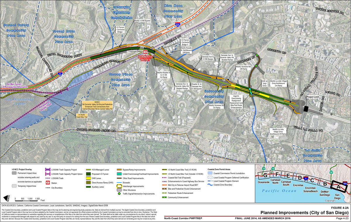
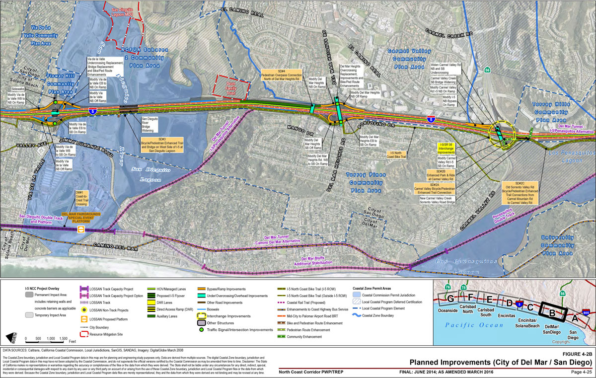
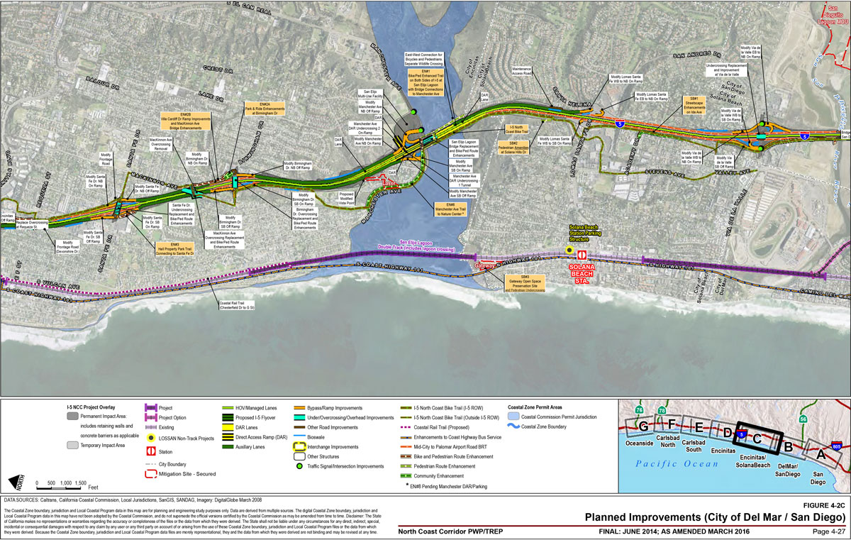
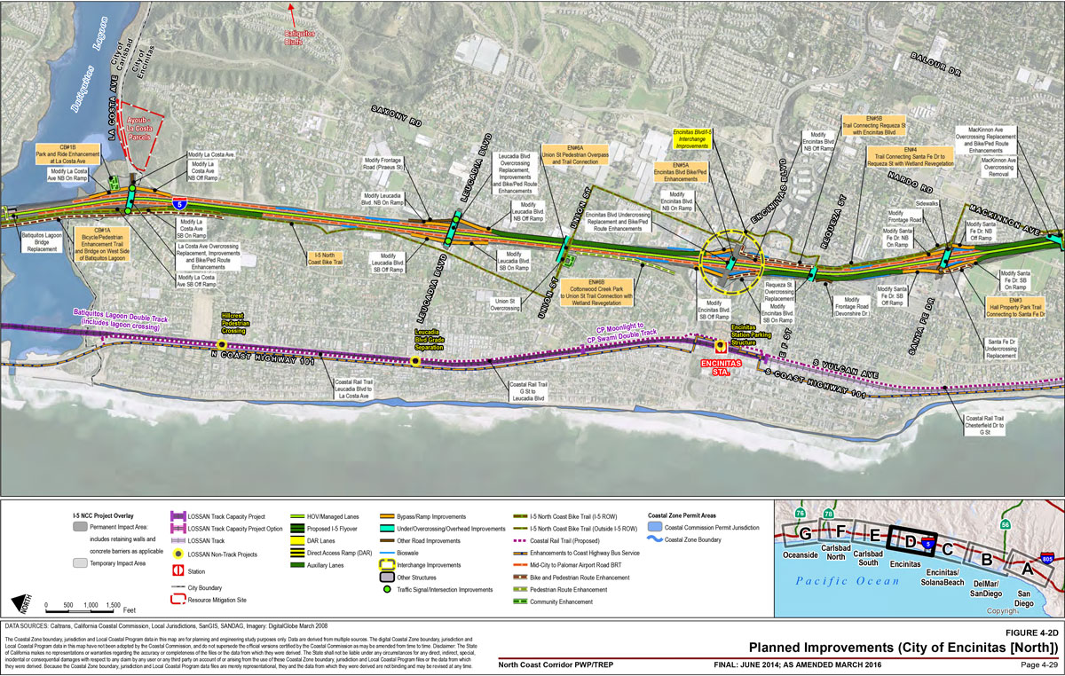
The program of improvements is described in the following sections and illustrated in Figure 4-2A through Figure 4-2G. This chapter includes only physical descriptions of the improvements. Potential benefits and impacts are described further in Chapter 5.
4.1 LOSSAN Rail Improvements
The "LOSSAN Final Program EIR/EIS "(September 2007) included programmatic level plans for rail in the NCC. The "San Diego - LOSSAN Corridor Project Prioritization Analysis "(July 2009) further defined potential rail projects, including operational improvements and other benefits and impacts. Projects are described in Table 4-1. These rail projects include a mix of double-tracking, other track capacity enhancements, rail bridge replacement, vehicle crossing improvements, parking expansion, new platform locations, and other station enhancements. Generally, track projects improve capacity directly and, therefore, improve reliability, reduce travel times, and provide the opportunity for increased service levels. Other improvements may increase access to rail services or improve the passenger experience, which may lead to increased ridership.
Given the program level of detail available for rail projects that the PWP/TREP indicates will be handled solely through federal consistency review, it is expected that federal consistency review for such rail improvements will be conducted in a phased manner. Similarly, rail projects that may be processed through the PWP may be subject to future PWP amendment and NOIDs to ensure consistency with the approved PWP; SANDAG/Caltrans may choose (in consultation with the Coastal Commission) to submit a coastal development permit application to the appropriate permitting agency.
4.1.1 Track Capacity
Just less than half of the LOSSAN rail corridor within the NCC is single track, which creates choke points when trains traveling in opposite directions meet.1 These conflicts create most of the delays in the corridor and corridor-wide double-tracking is necessary to sufficiently increase capacity and service. The LOSSAN rail program in the NCC includes double-tracking projects ranging in length from 0.6 to 2.7 miles. Other track improvements similarly increase capacity and decrease conflicts, which improves rail reliability and decreases travel times.
4.1.1.1 Double-Tracking
- Peñasquitos Double Track (San Diego): Construct 1.7 miles of a second main track and replace bridges through Peñasquitos Lagoon from Control Point (CP) Torrey to a new CP Carmel Mountain.2 This project would depend on the ultimate alignment of the Del Mar Tunnel (Section 4.1.4). (This project is identified in the "Unconstrained Vision" phase in Chapter 6).
- San Dieguito Double Track and Platform (Del Mar): Construct 1.1 miles of second main track from CP Valley to CP Crosby, replace the San Dieguito River Bridge, and construct a new special-event platform adjacent to the Del Mar Racetrack and Fairgrounds (platform discussed further in Section 4.1.2). This project would result in a 2.8-mile stretch of double-track from CP Craven to CP Del Mar.3
- San Elijo Lagoon Double Track (Encinitas): Construct 1.5 miles of double-track between CP Cardiff and CP Craven, modify the existing at-grade crossing at Chesterfield Drive, and replace the San Elijo Lagoon Bridge with a new 500-foot-long double-track bridge at MP 240.4. The project would result in 4.2 miles of double-track from CP Swami to CP Valley.
- CP Moonlight to CP Swami (Encinitas): Add a second main track for the 0.8-mile stretch between CP Moonlight and CP Swami, resulting in a 2.4-mile stretch of double-track from CP Moonlight to CP Cardiff.
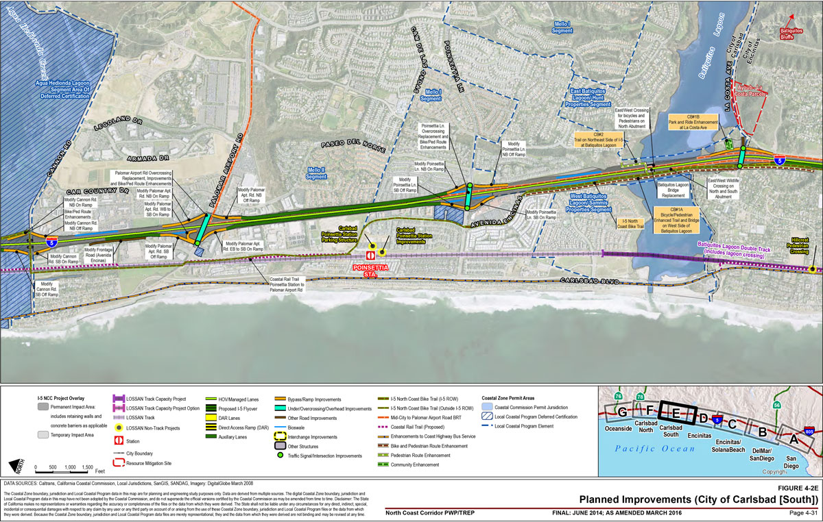
- Batiquitos Lagoon Double Track (Encinitas/Carlsbad): Construct 2.7 miles of a second main track between CP Ponto and CP Moonlight, replace the Batiquitos Lagoon Bridge, and expand the La Costa Avenue grade separation. This would result in 5.8 miles of double-track from CP Farr to CP Moonlight.
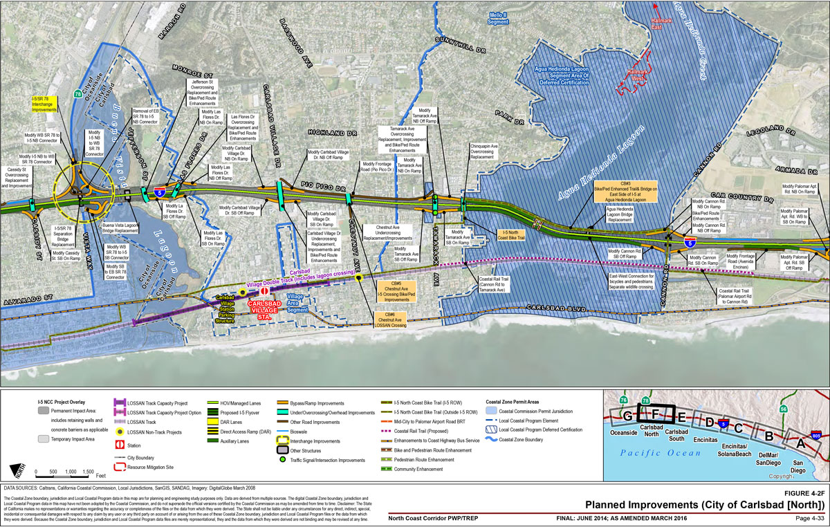
- Carlsbad Village Double Track (Carlsbad): Construct a 1.1-mile second main track and straighten a curve from Mile Post (MP) 228.4 to MP 229.5 including through the Carlsbad Village Station. This would lead to an 8.6-mile stretch of double-track from CP Shell to CP Ponto. The existing single-track bridge across Buena Vista Lagoon would be replaced with a new double-track bridge.4
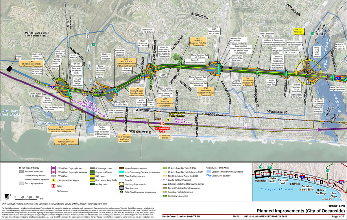
- East Brook to Shell Double Track: Add a second main track and replace the San Luis Rey River Bridge in the 0.6-mile segment from CP East Brook to CP Shell. This would result in a 3.6-mile stretch of double-track from CP Westbrook to CP Escondido Junction. The improvements would increase on-time performance for Metrolink and northbound Amtrak and reduce delays for southbound Metrolink trains.5
| Project | Location | Description | Extent (miles) | Phase |
|---|---|---|---|---|
| East Brook to Shell Double Track (includes San Luis Rey River Bridge) | Oceanside | Double-track; San Luis Rey River Bridge replacement. | 0.6 | Preliminary Engineering and Environmental Clearance |
| Oceanside Through Track | Oceanside | Addition of a third track and crossover to south of station to accommodate COASTER and Metrolink trains. | 0.3 | Design |
| Oceanside Transit Center Parking Structure | Oceanside | Addition of a parking structure. | – | Planning |
| Carlsbad Village Double Track | Carlsbad | Double-track; curve straightening on existing alignment. Buena Vista Lagoon Bridge replacement. | 1.1 | Preliminary Engineering and Environmental Clearance |
| Carlsbad Village Station Parking Structure | Carlsbad | Addition of a parking structure. | – | Planning |
| Carlsbad Poinsettia Station Parking Structure | Carlsbad | Addition of a parking structure. | – | Planning |
| Batiquitos Lagoon Double Track | Carlsbad/Encinitas | Double-track; Batiquitos Lagoon Bridge replacement; grade crossing expansion. | 2.7 | Preliminary Engineering and Environmental Clearance |
| Leucadia Boulevard Grade Separation | Encinitas | Grade separation at Leucadia Boulevard. | – | Preliminary Engineering and Environmental Clearance |
| Hillcrest Drive Pedestrian Crossing | Encinitas | Grade-separated pedestrian crossing at Hillcrest Drive (3 other crossings permitted prior to PWP/TREP). | – | Preliminary Engineering and Environmental Clearance |
| Encinitas Station Parking Structure | Encinitas | Addition of a parking structure. | – | Planning |
| CP Moonlight to CP Swami Double Track | Encinitas | Double-track. | 0.8 | Planning |
| San Elijo Lagoon Double Track | Encinitas | Double-track; replacement of San Elijo Lagoon Bridge, grade crossing at Chesterfield Drive. | 1.5 | Design |
| Solana Beach Station Parking Structure | Solana Beach | Addition of a parking structure. | – | Planning |
| San Dieguito Double Track and Platform | Del Mar | Double-track; replacement of San Dieguito Lagoon Bridge; construction of new platform for fairgrounds special events. | 1.1 | Preliminary Engineering and Environmental Clearance |
| Del Mar Bluffs Additional Stabilization | Del Mar | Replacement of eroded track bed support, protection of bluff face and reinforcement of bluff toe. | – | Planning |
| Del Mar Tunnel - Camino Del Mar or I-5/Peñasquitos | Del Mar | Alignment of tunnel and double-track beneath City of Del Mar or alignment of tunnel and double-track beneath I-5. | 2.7 / 4.6 | Planning |
| Peñasquitos Lagoon Double-Track | Del Mar | Double-track between CP Torrey and CP Carmel Mountain and replacement of Los Peñasquitos bridges. | 1.7 | Planning |
| Poinsettia Station Improvements | Carlsbad | Reconstruct tracks, realign platform and grade-separate pedestrian crossing at Carlsbad Poinsettia station. | – | Design |
4.1.1.2 Other Track Improvements
- Oceanside Through Track (Oceanside): Expand the rail portion of the station to the north and south, and add a third rail track to the southern end of the station. The existing boarding platform would be extended to the north. The southern end of the existing Platform 1 would be removed, and a new walkway would lead passengers to a new southern boarding platform. A series of turnouts and crossovers would be installed to enable trains to move laterally from track to track as they approach the platforms. Platform improvements would also be implemented. The improvements would allow for more simultaneous passenger train boarding of multiple train services, thus reducing travel times and facilitating future expansions of rail service. Freight trains, which now wait outside the station when passenger trains are present, would be able to pass through the station unimpeded.
- Del Mar Bluffs Additional Stabilization (Del Mar): Replace eroded track bed support, protect bluff face and reinforce bluff toe in order to provide continued operation of the rail service.
4.1.1.3 Bridge Replacement
Bridges throughout the corridor would be replaced in order to accommodate double-tracking. Additionally, many bridges have been in service for multiple decades and are structurally degraded, compounding the need for replacement. Other existing bridges would need a parallel bridge built to support corridor double-tracking. In some situations, bridge spans would be lengthened–and their footprints would be reduced–due to changes in bridge design and construction materials, including replacing creosote piles with longer spans and concrete piles. All new bridge structures would be designed to avoid and minimize impacts to adjacent sensitive resources. This analysis has been conducted as a part of the associated bridge optimization studies and would result in improved water quality, hydrologic connectivity and decreased sedimentation.
Track improvements that cross lagoons and therefore include bridge replacements are the following (additional information about each project is provided in Section 4.5):
- Peñasquitos Double Track: Includes bridge replacements through Peñasquitos Lagoon (dependent upon the selection of a tunnel alignment through Del Mar).
- San Dieguito Double Track and Platform: Includes San Dieguito River Bridge.
- San Elijo Lagoon Double Track: Includes San Elijo Bridge.
- Batiquitos Lagoon Double Track: Includes Batiquitos Lagoon Bridge.
- Carlsbad Village Double Track: Includes Buena Vista Lagoon Bridge.
- East Brook to Shell Double Track: Includes San Luis Rey River Bridge.
4.1.2 Station and Parking Improvements
The following station and parking improvements at LOSSAN corridor rail stations would increase passenger capacity, improve service, and enhance quality of service. (Parking improvements adjacent to I-5, such as park-and-ride lots, are listed in Section 4.2.6.) These improvements are all in the planning stage with the exception of Poinsettia Station Improvements, which are being designed.
- Solana Beach Station Parking (Solana Beach): Additional spaces at, adjacent to, or in close proximity to the COASTER Solana Beach Station.
- Encinitas Station Parking (Encinitas): Additional spaces at, adjacent to, or in close proximity to the COASTER Encinitas Station.
- Poinsettia Station Parking (Carlsbad): Additional spaces at, adjacent to, or in close proximity to the COASTER Carlsbad Poinsettia Station.
- Poinsettia Station Improvements (Carlsbad): Installation of an inter-track fence and a grade-separated pedestrian crossing at Carlsbad Poinsettia Station. New station platforms would be constructed to accommodate these improvements. The project is in the design stage and requires environmental approval.
- Carlsbad Village Station Parking (Carlsbad): Additional spaces at, adjacent to, or in close proximity to the COASTER Carlsbad Village Station.
- Oceanside Station Parking (Oceanside): Additional spaces at, adjacent to, or in close proximity to the existing Oceanside Transit Center to accommodate additional riders who access the station by private automobile.
Beyond the parking improvements planned at LOSSAN rail stations, several improvements to park-and-ride facilities on I-5 are also planned in the PWP/TREP. They are described in Section 4.2.6 with the other highway projects.
Some station platform projects improve access from special activity centers to the corridor's passenger rail services. Within the corridor, one station platform project is included:
- Del Mar Fairgrounds Special Event Platform (Del Mar): Part of the San Dieguito Double Track and Platform project (Section 4.1.1) is a new special events platform for the Del Mar Racetrack and Fairgrounds, to be located along the existing railway adjacent to the fairgrounds. The 1,000-foot platform with access to both main line tracks would provide seasonal access for special events. Ramps and steps would provide a direct link to the fairgrounds' parking lot. The platform and track would be elevated to be higher than the floodplain.
4.1.3 Roadway Grade Separations
Grade separations at crossing points between rail tracks and roadways improve safety and performance for all modes. The following roadway grade separations are planned for the corridor and identified in the "Unconstrained Vision" phase in Chapter 6:
- Leucadia Boulevard Grade Separation (Encinitas): An undercrossing of Leucadia Boulevard (MP 236.5) in Encinitas.
- Two Additional Roadway Grade Separations: Two additional grade separations between surface streets and the LOSSAN rail corridor are planned in the San Diego Association of Governments (SANDAG) 2050 Regional Transportation Plan (2050 RTP). The locations of these grade separations will be determined as part of the regional planning process and may be in the NCC. As discussed in Chapter 6A, additional project review would be required once more project details become available.
In addition to these roadway grade separations, five additional grade-separated crossings of the LOSSAN rail corridor are planned exclusively for bicycle and pedestrian users. They are listed below, and discussed in greater detail in Section 4.4 with the other bicycle and pedestrian improvements:
- Coast to Crest Trail Crossing (Del Mar): Also listed as Community Enhancement DM#1.
- San Elijo Lagoon Gateway Pedestrian Undercrossing (Solana Beach): Part of Community Enhancement SB#3.
- Hillcrest Drive Pedestrian Undercrossing (Encinitas)
- Chestnut Avenue LOSSAN Pedestrian Crossing (Carlsbad): Also listed as Community Enhancement CB#6.
- Harbor Drive LOSSAN Crossing Bicycle/Pedestrian Improvements (Oceanside): Also listed as Community Enhancement OC#12.
4.1.4 Tunnels
The SANDAG 2050 RTP includes a rail tunnel to move the existing rail alignment away from the Del Mar bluffs, which are susceptible to failure and unable to accommodate double-tracking due to significant excavation, stabilization and ongoing maintenance needs of such a facility. The alignment of the tunnel is undecided and will be determined through an alternatives analysis.
There are two alternatives included in the LOSSAN Final Program EIR/EIS. The first would run underneath Camino Del Mar where tracks would then connect with the existing LOSSAN alignment across Los Peñasquitos and San Dieguito Lagoons. The second alternative tunnel would run under I-5 and daylight along the southern bluffs of the San Dieguito Lagoon. Tracks would reconnect with the existing LOSSAN rail corridor at-grade near the Del Mar race track. Should either of these tunnel options be selected, the existing rail track on the Del Mar bluffs would be removed from service. SANDAG is conducting a summary-level planning study of these alternatives in order to determine their influence on the design of the San Dieguito Bridge Replacement and Double-Track project. Further study is needed before an ultimate alignment is chosen and these tunnel alternatives are identified in the "Unconstrained Vision" phase in Chapter 6.
- Del Mar Tunnel, Camino Del Mar Option: Construct a tunnel and second main track beneath Camino Del Mar from MP 243.6 to MP 245.5.
- Del Mar Tunnel, I-5/Peñasquitos Option: Construct a tunnel and second main track beneath I-5, bypassing Peñasquitos Lagoon and surfacing south of San Dieguito Lagoon.
4.2 I-5 Highway Improvements
The I-5 NCC improvements would maintain or improve existing and future traffic operations on the existing I-5 freeway from La Jolla Village Drive in San Diego to Harbor Drive in Oceanside/Camp Pendleton, extending approximately 27 miles. In July 2011, Caltrans identified the 8+4 Buffer alternative as the Locally Preferred Alternative (LPA). The LPA consists of two high-occupancy vehicle (HOV)/Express Lanes in each direction, separated by a buffer from the existing four general-purpose lanes in each direction. This configuration is shown in Figure 4-1. The project includes the following elements:
- One new HOV/Express Lane in each direction from La Jolla Village Drive to just north of Lomas Santa Fe Drive. There is already one existing HOV/Express Lane in each direction from the I-5/I-805 merge to Lomas Santa Fe Drive, resulting in two total HOV/Express Lanes in each direction.
- Two HOV/Express Lanes in each direction would be added from just north of Lomas Santa Fe Drive to Harbor Drive/Vandegrift Boulevard.
- A buffer separating general-purpose lanes and HOV/Express Lanes varying in width up to 5 feet from near La Jolla Village Drive to Harbor Drive/Vandegrift Boulevard.
- Provision of a continuous HOV lane in each direction through the I-5 / I-805 junction with a freeway-to-freeway connector (flyover), crossing over the I-5 / I-805 merge and connecting the proposed project HOV/Express Lanes to existing HOV lanes just north of that merge.6
Additional project elements, including direct access ramps (DARs), auxiliary lanes, lagoon bridges, crossings, gateway features, park-and-ride facilities, ramp and interchange improvements, and Intelligent Transportation Systems (ITS) are discussed in the following sections.
4.2.1 Express Lanes and Direct Access Ramps
Express Lanes enable the more efficient use of highway lanes and reduced travel times for the HOVs and fee-paying single-occupancy vehicles using the lanes. Conditions in Express Lanes can be controlled through real-time monitoring and traffic operations adjustments in order to achieve free-flow speeds and reliable travel times. Express Lanes operate as HOV lanes with transit vehicles, carpools and other HOVs traveling at free-flow speeds. Any additional capacity in the lanes, while still ensuring they are freely moving, can be used by single-occupancy vehicles (SOV) paying a fee. The fee varies in order to keep travel times reliable. A higher premium is therefore paid to use the uncongested Express Lanes when the general-purpose lanes are congested. Revenue from the lanes is invested in corridor transportation, specifically HOV facilities and transit service and operations. In the future as needs, priorities and demand changes, the facility is operationally flexible to adjust through changes to pricing, vehicle eligibility, and access control. Future transit service, including corridor bus rapid transit (BRT) service (see Section 4.3.1), has prioritized infrastructure to operate on. Additionally, Express Lanes allow for a large investment in HOV and transit capacity to be smoothed by providing managed access to SOVs. As HOV use grows, the percentage of SOVs using the lanes would decrease. The Express Lanes create a facility that focuses on moving people, not vehicles through the corridor. Express Lanes provide reliability to transit users, carpoolers and others who need reliability in their trips.
Express Lanes would be separated from the general-purpose lanes by a buffer that would vary in width (by up to 5 feet) and would be indicated with striping. Access and egress points would be limited to DAR and Intermediate Access Points (IAP). DARs allow direct access into the Express Lanes from overcrossings or tunnels at or near Voigt Drive (San Diego) and Manchester Avenue (Encinitas). The Manchester Avenue DAR would feature a park-and-ride facility and provide direct access not only to the Express Lanes for HOVs, but also to the San Elijo Multi-Use Facility, recreational facilities near San Elijo Lagoon (Section 4.2.6). The Manchester DAR also offers future opportunities for a BRT/transit station with access to the Express Lanes for potential future BRT along El Camino Real. DARs reduce congestion and improve reliability because they provide a dedicated access route from a grade-separated interchange into Express Lanes for users and do not require drivers to weave across multiple general-purpose lanes. DARs are compatible with carpools, bus transit, and value pricing, and would support HOV/Express Lanes.
DAR locations were determined to best serve corridor travel needs. The locations provide direct access to the corridor's major activity centers, transit centers, origins, and destinations and while ensuring appropriate spacing. DAR locations and the activity centers they would provide links to are outlined in Table 4-2. Additionally, the Manchester Avenue DAR is located where parallel arterials end and therefore is a major access and egress point for I-5.
| Direct Access Ramps Locations | Activity Center |
|---|---|
| Voigt Drive - San Diego | UCSD, hospitals, employment center, shopping, hotels, future transit hub. |
| Manchester Avenue - Encinitas | Public beach, future transit hub, community college, town centers. |
Additionally, Express Lane users are able access the lanes at specific access and egress points, also known as IAPs. Charged tolls would be posted and those who wanted to use the Express Lanes could merge into the facility from the general-purpose lanes. Fees for SOVs would be charged at access/egress points when the vehicles pass under overhead suspended scanners. In addition to suspended scanners, access points would have electronic signs displaying the current toll of various segments in the corridor. Ingress and egress locations are shown in Table 4-3.
| Northbound Ingress/Egress | Southbound Ingress/Egress | |
|---|---|---|
| La Jolla Village Drive | X | X |
| Carmel Mountain Road (IAP) | X | X |
| Del Mar Heights Road/Via de la Valle (IAP) | X | X |
| Lomas Santa Fe Drive (IAP) | X | X |
| Santa Fe Drive (IAP) | X | X |
| Poinsettia Lane (IAP) | X | X |
| Tamarack Avenue (IAP) | X | X |
| Oceanside Boulevard (IAP) | X | X |
| Harbor Drive | X | X |
Note: Intermediate Access Points (IAP) where noted. La Jolla Village Drive and Harbor Drive are access points at ends of HOV/Express Lanes.
Violations in the HOV/Express Lanes law would be enforced by California Highway Patrol (CHP) based on an agreement with SANDAG similar to existing operations on the I-15 Express Lanes. This would include a combination of routine and special enforcement to ensure only HOV and vehicles with valid transponders are using the lanes.
4.2.2 Auxiliary Lanes
Auxiliary lanes are lanes on the outside of the freeway that typically connect on-/off-ramps and allow for weaving, acceleration, deceleration, merging, truck climbing, and other purposes supplementary to through traffic. These lanes maximize the capacity of a facility by reducing congestion caused by weaving and variable travel speeds. In the NCC, where access to local streets from I-5 (ramp volume) is high due to local trips using the freeway, the distances between interchanges is short, and freeway volumes are high, merging movements create greater levels of congestion. As such, 12-foot-wide auxiliary, acceleration, and deceleration lanes with shoulders up to 12 feet wide are planned for certain segments within the corridor. Auxiliary lanes improve the efficiency of the highway facility by moving disruptive merging out of the main travel lanes.
I-5 has, and would retain auxiliary lanes in the following segments:
- Genesee Ave to Sorrento Valley Road (Roselle Street) (NB deceleration lane)
- Genesee Ave to NB I-5 Bypass Lanes (NB weaving lanes)
- Carmel Mountain Road to Carmel Valley Road (NB weaving lane)
- Carmel Valley Road to Del Mar Heights Road
- Del Mar Heights Road to Via de la Valle (SB weaving lane; NB deceleration lane terminating at the Via de la Valle NB off-ramp would be extended to begin at the Del Mar Heights Road NB on-ramp)
- Via de la Valle to Lomas Santa Fe Drive
- Lomas Santa Fe Drive to Manchester Avenue
- La Costa Avenue to Poinsettia Lane (NB deceleration lane; SB acceleration lane)
- Palomar Airport Road to Cannon Road (NB weaving lane; SB acceleration lane beginning at the Cannon Road SB on-ramp would be extended to terminate at the Palomar Airport Road SB off-ramp)
- Cannon Road to Tamarack Avenue (NB acceleration lane beginning at the Cannon Road NB on-ramp would be extended to terminate at the Tamarack Avenue NB off-ramp)
- Carlsbad Village Drive to Las Flores Drive
- Las Flores Drive to Vista Way/State Route (SR) 78
- Vista Way/SR 78 to Cassidy Street
- Cassidy Street to California Street (NB only)
- California Street to Oceanside Boulevard (NB only)
- Mission Avenue to SR 76 (SB only)
- SR 76 to Harbor Drive
New or modified auxiliary lanes are proposed for the following segments:
- La Jolla Village Drive to Genesee Avenue (NB and SB weaving lanes)
- Genesee Avenue to Roselle Street (SB acceleration lane only)
- Del Mar Heights Road to Via de la Valle (extension NB as stated above)
- Lomas Santa Fe to Manchester Avenue (NB acceleration lane)
- Manchester Avenue to Birmingham Drive (NB and SB weaving lanes)
- Birmingham Drive to Santa Fe Drive (NB and SB weaving lanes)
- Santa Fe Drive to Encinitas Boulevard (SB weaving lane only)
- Encinitas Boulevard to Leucadia Boulevard (NB weaving lane only)
- Leucadia Boulevard to La Costa Avenue (SB acceleration lane only)
- Poinsettia Lane to Palomar Airport Road (NB and SB weaving lanes)
- Palomar Airport Road to Cannon Road (extension SB only as stated above)
- Cannon Road to Tamarack Avenue (extension NB only as stated above; SB weaving lane)
- Carlsbad Village Drive to SR 78 (extension SB only)
- Las Flores Drive to SR 78 (NB deceleration lane only)
- SR 78 to Cassidy Street (SB weaving lane; an existing SB auxiliary-weaving-lane would extend to the new SB auxiliary-weaving-lane that would begin at Oceanside Boulevard SB on-ramp)
- Cassidy Street to Oceanside Boulevard (extension of NB; SB weaving lane)
- Oceanside Boulevard to Mission Avenue (NB and SB weaving lanes)
- Mission Avenue to SR 76 (NB weaving only)
- SR 76 to Harbor Drive (NB deceleration lane, extension SB)
4.2.3 Lagoon Bridges
As I-5 passes through the NCC, it crosses five coastal lagoons. As such, the bridges that cross these lagoons would need to be upgraded or replaced as part of the project. This includes the replacement of some lagoon bridges and the lengthening of the I-5 bridges crossing San Elijo, Batiquitos and Buena Vista Lagoons. Lagoon bridge project descriptions are provided in the I-5 NCC Project Final EIR/EIS (October 2013).
One of the five existing lagoon bridges (crossing San Dieguito Lagoon) is relatively new with minor changes that do not require replacing the existing bridge. The remaining four lagoon bridges, including the I-5 crossings at San Elijo, Batiquitos, Agua Hedionda, and Buena Vista Lagoons, would be replaced due to the age of the existing bridge and increased width required for the project. Bridges would have a minimum width of 188 feet. The proposed bridge dimensions are summarized in Table 4-4 and additional project elements for these lagoons and their related waterways are identified below.
| Bridge Structures | Bridge Existing Length Dimensions |
Bridge Existing Width Dimensions |
Bridge Proposed Project Length |
Bridge Proposed Project Width |
Notes |
|---|---|---|---|---|---|
| Los Peñasquitos Lagoon | – | – | – | – | – |
| Soledad Canyon Creek (Flyover Bridge) |
N/A | N/A | 863 | 60 | HOV Connector flyover bridge across the creek.
The HOV Connector consists of two bridges connected in the center by a portion of roadway that lies on an embankment outside of the creek. The flyover bridges directly above the Soledad Creek and Los Peñasquitos Creek, respectively, are noted above. The total length of the HOV Connector would approximately be 4,459 feet, while the two bridges combined would approximately be 4,239 feet. |
| Los Peñasquitos Creek (Flyover Bridge) |
N/A | N/A | 3,376 | 60 | HOV Connector flyover bridge across the creek.
The HOV Connector consists of two bridges connected in the center by a portion of roadway that lies on an embankment outside of the creek. The flyover bridges directly above the Soledad Creek and Los Peñasquitos Creek, respectively, are noted above. The total length of the HOV Connector would approximately be 4,459 feet, while the two bridges combined would approximately be 4,239 feet. |
| Carmel Creek (Main I-5 Bridge) |
421 | 179-209 | 421 | 188-225 | Bridge would be widened to the west. |
| Sorrento Valley (Bicycle Bridge) |
N/A | N/A | 443 | 15 | – |
| San Dieguito Lagoon | 650 | 179 | 650 | 258 | Bridge would be widened to the west and east. |
| San Elijo Lagoon | 340 | 176-188 | 560 | 303-388 | Width in bridge varies due to Manchester Avenue on- and off-ramps. Bridge supports would include 3 rows of approximately 12 or 13 columns each. |
| Batiquitos Lagoon | 219 | 2-68ft bridges w/ 19.2ft gap | 282 | 2-101ft bridges w/ 19.2ft gap | Bridge supports would include 2 rows of 10 columns each. |
| Agua Hedionda Lagoon | 191 | 157.5 | 191 | 269 | – |
| Buena Vista Lagoon | 102.4 | 184 | 197 | 310 | Bridge supports would include 2 rows of 32 columns each. |
Minimal changes are proposed to the I-5 bridges in the vicinity of Los Peñasquitos Lagoon because the majority of the widening for HOV/Express Lanes was completed in the 1990s and early 2000s as part of the I-5/I-805/SR 56 interchange projects. Additionally, I-5 does not cross Los Peñasquitos Lagoon but instead creeks that feed into it. As a result, the proposed I-5 bridge over Carmel Creek needs to be widened by only 15 feet on the western side of the bridge to accommodate the second southbound HOV/Express Lane. Los Peñasquitos Creek and Soledad Creek would be crossed by two HOV/Express Lanes flyover bridges (3,376 feet long by 60 feet wide over Los Peñasquitos Creek; and 836 feet long by 60 feet wide over Soledad Creek) added to I-5 at the I-5/I-805 merge. In addition to these I-5 bridges, the Old Sorrento Valley Road crossing of Carmel Creek would be replaced with an upgraded bicycle and pedestrian trail, new bioswales and removal of the box culverts that convey Carmel Creek would be replaced with a bridge.
Across San Dieguito Lagoon, the project proposes to maintain the existing auxiliary lanes and widen the existing lagoon bridge to accommodate the LPA configuration rather than replace the bridge. The bridge width would be expanded from 179 to 258 feet; an increase of 79 feet. A short retaining wall would be placed on the east side of I-5 south of the San Dieguito River to avoid encroachment into a wetland at the base of the I-5 slope. A new bike/pedestrian path is proposed on the western freeway slopes across San Dieguito Lagoon. This would cross the lagoon in an area where no crossing exists, and would provide a possible connection to the Coast to Crest Trail. The bicycle/pedestrian path would be cut into a large fill slope south of the river. Where actually crossing the lagoon, the bicycle/pedestrian path would be suspended from the existing I-5 bridge.
At Agua Hedionda Lagoon, the proposed bridge would retain the existing 191-foot length, but would be approximately 269 feet wide with auxiliary lanes in both directions, an increase of 111.5 feet over the existing structure. The new bridge would be similar in design to the existing I-5 bridge designs at Batiquitos Lagoon. Specifically, it would have two rows of 16 four-foot diameter columns (cast-in-place drilled hole footings). Fewer columns would also result in less obstruction in the channel, and therefore, lower potential to slow flow through the bridge. The proposed bridge would have a channel bottom width of 76 feet, equal to the existing bridge cross section, with 2:1 channel slopes. A 16-foot-wide bench for crossings would be placed on both the northern and southern abutments; and a north/south bicycle/pedestrian path across the lagoon is proposed on the eastern side of I-5.
The I-5 bridge over San Elijo Lagoon is proposed to be 560 feet long. Construction of the new bridge would require a width of 303 to 388 feet to accommodate the construction area. The bridge width would vary due to the widening required for the on- and off-ramps to Manchester Avenue. A 265-foot channel bottom width is proposed, pursuant to lagoon optimization analysis. A 12-foot-wide bench to facilitate wildlife movement would be provided on the I-5 southern abutment, below a proposed 12-foot-wide fenced pedestrian path. In addition to the pedestrian path on the southern abutment and along the eastern fill slopes (similar to existing conditions), a proposed bicycle/pedestrian path connection would be provided on the western side of I-5 from Lomas Santa Fe to Manchester Avenue. The connection would be on a secondary bridge suspended from the I-5 structure.
The I-5 bridge over Batiquitos Lagoon is proposed to be 282 feet long, broken into north- and southbound bridges–each 127 feet wide with a 19.2-foot gap between them. The channel bottom would be 183.5 feet wide with a depth of -7 (National Geodetic Vertical Datum [NGVD]). The new channel would be a trapezoid with a level bottom between the abutments. The dimensions of the bottom would result in the same overall cross section as the modeled optimized bridge with a variable sloped bottom and the same width at -1.0 foot elevation (NGVD). The existing riprap within the channel bottom would be removed. The new I-5 bridge configuration would be similar to the existing bridge (i.e., two bridge structures with a gap separating the north- and southbound lanes). New abutments would be built with 16-foot benches (for wildlife movement on the southern abutment, and for use as a pedestrian path and a wildlife corridor on the northern abutment).
The current enhanced I-5 bridge over Buena Vista Lagoon is proposed to be 197 feet long and 310 feet wide. Channel bottom width is estimated to be 105 feet wide and -6.0 feet (NGVD). Sixteen-foot benches for wildlife crossings would be built at both north and south I-5 abutments to accommodate use by small- and medium-sized mammals.7
4.2.4 Over and Undercrossing Replacement and Upgrading
To accommodate widening, most corridor overcrossings (Table 4-5) and undercrossings would need to be replaced or widened. This is in addition to the lagoon bridges identified in Section 4.2.3. Structure rehabilitation and upgrading presents the opportunity to upgrade and reconfigure local interchanges to improve pedestrian and bicycle circulation. The bicycle and pedestrian improvements are discussed further in Section 4.4.
The following undercrossings would be replaced:
- Carmel Valley Road Undercrossing would be widened (NB and SB directions)
- Via De La Valle
- Manchester Avenue
- Santa Fe Drive
- Encinitas Boulevard
- Cannon Road
- Chestnut Avenue
- Carlsbad Village Drive
- Oceanside Boulevard Overhead
- I-5/SR 76 Separation
- Harbor Drive/Camp Pendleton
In addition to over- and undercrossing replacements and bridges required to cross lagoons, the project would include additional new bridge structures as follows:
- Voigt Drive DAR
- Genesee Northbound Braided Ramp
- Genesee Southbound Braided Ramp
- I-5 HOV Flyover Connector I & II - at I-805 merge8
- Carmel Creek - Sorrento Valley Road
- Manchester DAR Undercrossing Tunnel (I-5 Northbound)
- Manchester DAR Undercrossing at Northbound On-Ramp
- Oceanside Boulevard Overhead (NB Off-Ramp)
- Harbor Drive Undercrossing (I-5 Northbound Off-Ramp)
4.2.5 Regional and Local Gateway Features
Along the I-5 highway corridor, several key interchanges serve as the primary entryways to the region as well as local communities. The planned highway improvements include gateway features at these locations, which would contain artistic elements and other design treatments to enhance views, increase natural light, and create an inviting multimodal atmosphere around the interchange crossing.
| Location | Improvement |
|---|---|
| Carmel Valley Creek Bridge | Southbound Widening |
| San Dieguito River Bridge | Northbound/Southbound Widening |
| San Elijo Lagoon Bridge and Manchester Avenue Undercrossing | Replaced |
| Birmingham Drive Overcrossing | Replaced |
| Mackinnon Avenue Overcrossing | Replaced |
| Requeza Street Overcrossing | Replaced |
| Leucadia Blvd. Overcrossing | Replaced |
| La Costa Avenue Overcrossing | Replaced |
| Batiquitos Lagoon Bridge | Replaced |
| Poinsettia Lane Overcrossing | Replaced |
| Palomar Airport Road Overcrossing | Replaced |
| Aqua Hedionda Lagoon Bridge | Replaced |
| Chinquapin Avenue Overcrossing | Replaced |
| Tamarack Avenue Overcrossing | Replaced |
| Las Flores Drive Overcrossing | Replaced |
| Jefferson Street Overcrossing | Replaced |
| Buena Vista Creek Bridge | Replaced |
| SR 78/I-5 Separation | Replaced |
| Cassidy Street Overcrossing | Replaced |
| California Street Overcrossing | Replaced |
| Loma Alta Creek Bridge | Replaced |
| Brooks Street Overcrossing | Replaced |
| Mission Avenue Overcrossing | Replaced |
| Fourth St/Bush Street Overcrossing | Replaced |
| Neptune Way/8th Street Overcrossing | Replaced |
| San Luis Rey River Bridge |
Replaced |
There is one gateway feature of regional significance planned:
- Regional Gateway Feature at Harbor Drive (Oceanside): Construct an art feature to serve as an entryway to Oceanside and the San Diego region. The design, which has not yet been decided, would be developed with input from the community and could include creative paving, evocative landscaping, and iconic structures that represent the region.
In addition, local gateway features are planned at several interchanges that would provide access to the corridor's town centers. As described in the Interstate 5 North Coast Corridor Project Design Guidelines (included as Appendix A to the PWP/TREP), these crossings are intended to "visually communicate their role as gateways to freeway drivers as well as those using local surface streets."9 They would provide bicycle and pedestrian-friendly improvements on the local streets and integrate human-scale elements such as lighting and material textures. The local gateway interchanges are:
- Via De La Valle (San Diego): Provide primary access to Del Mar.
- Encinitas Boulevard (Encinitas): Provide primary access to downtown Encinitas.
- Carlsbad Village Drive (Carlsbad): Provide primary access to downtown Carlsbad.
- Mission Avenue (Oceanside): Provide primary access to downtown Oceanside.
The Interstate 5 North Coast Corridor Project Design Guidelines also note that gateway interchanges exist at Genesee Avenue (gateway to San Diego) and Lomas Santa Fe Drive (gateway to Solana Beach). While the improvements to these interchanges have been permitted separately from the PWP/TREP, they are expected to include gateway elements similar to the interchanges listed above. Coordination with the affected cities is underway to determine the preferred features at each location.
4.2.6 Park-and-Ride Improvements
The I-5 highway corridor contains several park-and-ride lots that facilitate carpooling and other ride-sharing activities. Many also serve as parking and staging areas for corridor recreational facilities such as lagoon trails and upland resources. By providing transportation options beyond single-occupant driving, these park-and-ride lots encourage alternative transportation modes and contribute to improved traffic conditions on I-5. In addition, they will help facilitate future transit services, such as BRT, that could be planned for the corridor (Section 4.3.1).
Parking is provided at four existing park-and-ride facilities along I-5 in the NCC (Carmel Valley, Birmingham, La Costa, and at the 5/78 interchange). Three of these existing park-and-ride facilities are planned for improvement, including maximization of available space for parking, and are classified as community enhancement projects and described further in Section 4.4.5. The three facilities are:
- Carmel Valley Road Park-and-Ride (San Diego): Also known as community enhancement SD#2B.
- Birmingham Drive Park-and-Ride (Encinitas): Also known as community enhancement EN#2A.
- La Costa Avenue Park-and-Ride (Carlsbad): Also known as community enhancement CB#1B.
Additionally, one new park-and-ride facility is planned: - Manchester Avenue DAR and San Elijo Multi-Use Facility (Encinitas): Parking for approximately 150 cars, along with a BRT platform and an access road connecting to the DAR (described in Section 4.2.1).
Altogether, the number of park-and-ride spaces available for HOV commuters along I-5 will increase by at least 43% with implementation of these planned new and enhanced park-and-ride facilities, and could increase by even more depending on the ultimate design of each facility. Beyond the park-and-ride improvements planned at I-5, improvements to the parking facilities at, adjacent to, or in close proximity to LOSSAN rail stations are also planned in the PWP/TREP. They are described in Section 4.1.2 with the other LOSSAN projects.
4.2.7 Ramp and Interchange Improvements
To accommodate widening and improve vehicular, pedestrian and bicycle circulation, local interchange ramps would undergo modifications. While the basic configuration would generally remain, the number of lanes and alignment would be modified to ensure that they accommodate expected traffic volumes and conform to current design standards. At some interchanges, ramps would be modified to address expected increases in local traffic and resulting accessibility needs. Most ramps would have HOV bypass lanes. Interchange improvements are shown in Table 4-6 and Table 4-7.
4.2.8 Intelligent Transportation System Features
The corridor already has ITS elements in place that would be supplemented by further improvements as part of the Transportation Managements System improvement plan for the corridor and region. These elements manage congestion using historical data, real-time information, and control and advanced communication networks to provide information about system operations to users and operators so they can make informed travel decisions. Additionally, ITS features improve the efficiency of existing infrastructure and reduce the need for major capacity increasing projects. Within the corridor, multiple ITS components are planned, including:
- Twenty-seven miles of new fiber-optic cable - Relaying real-time traffic information to highway operators and to signage along the corridor.
- Five new changeable message signs - Conveying information to motorists, including traffic conditions, alternate routes, special event, or traffic incident information. For Express Lanes, these signs would display tolls.
- Between 15 and 20 new closed circuit television cameras - Providing visual analysis of the freeway and congestion and security surveillance.
- Two new highway advisory radio channels - Providing drivers with real-time information about highway conditions to allow for educated travel decisions.
- New vehicle detection systems at five locations (nine total) - Detection devices provide traffic managers real-time information about how the freeway is operating.
- Arterial interconnect signals on El Camino Real - Maximizing the capacity of an existing facility.
- Ramp meters - Creating consistent and even flow - and a coordinated corridor-wide ramp metering system - Ultimately metering at all 58-on-ramps at buildout.
- Arterial signal timing enhancements.
4.2.9 Sound Walls, Retaining Walls, and Other Elements
Where feasible and reasonable, sound walls, or other forms of noise abatement, would be used based on the Caltrans Noise Protocol. Noise walls may be recommended as described in the I-5 NCC Project Final EIR/EIS (Section 3.15, October 2013). That document describes sound walls required under a different highway footprint (10+4 with Buffer Alternative) and would therefore be revised and confirmed during final design. Following the final noise studies and prior to the Notice of Impending Development process, the location and size of sound walls and retaining walls will be reevaluated for feasibility, reasonableness, and impacts to coastal character.
Multiple retaining walls have been proposed along the I-5 alignment. Retaining walls would be used to reduce property acquisition needs, stabilize slopes, minimize impacts and accommodate engineered structures. In general, Caltrans' standard retaining walls (Type 1 through Type 5) or crib walls may be used without special design. Non-standard retaining walls may be utilized in suitable locations, but would require additional support work and design during the project design phase.
Design for safety devices, guard rails, end treatments, crash cushions, bridge rails, signs, and drainage improvements would all be designed consistent with Caltrans best practices and applicable mandatory design standards. Existing overhead and underground utilities (water, sewer, gas, electricity telephone, and other communications) would be relocated, as needed and within existing utility easements, where possible.
4.3 Other Transportation Improvements
In order to fully understand and analyze the program of improvements in the NCC, the PWP/TREP includes other transportation enhancements planned for the corridor. Inclusion of these projects provides a comprehensive understanding of the mobility and resource benefits and impacts planned for the corridor. Each of these additional projects would be analyzed through separate environmental processes and are not addressed in the LOSSAN or I-5 environmental documents discussed in Sections 4.1 or 4.2, respectively. These enhancements are included in Figures 4-2A through 4-2G.
4.3.1 Bus Rapid Transit (BRT)
A BRT route would use the new I-5 Express Lane facility as identified in the SANDAG 2050 RTP. BRT combines stations, enhanced vehicles, ITS, and priority running ways into a premier rubber-tire transit alternative with fast, frequent, and high-quality service. The first planned service for I-5, known in the 2050 RTP as Route 653, is a reverse-commute BRT that targets the peak-period commute trip between the high-density Mid City residential area in central San Diego and the Palomar Airport Road business park in the NCC. It would travel via Kearny Mesa/I-805 and the I-5 HOV/Express Lanes. Buses are planned to run at 15-minute intervals during the peak period by 2035. Although other routes have not been planned yet, additional BRT or traditional bus routes could use the Express Lanes and reap the same travel-time and reliability benefits. Such operations would be facilitated by the proposed DARs at Voigt Drive and Manchester Avenue, the new park-and-ride facilities planned at Manchester Avenue (San Elijo Multi-Use Facility) and SR 76, and enhanced park-and-ride facilities at other locations.
4.3.2 Enhancements to Coast Highway Bus Service
The PWP/TREP and 2050 RTP include improvements to existing bus service along Coast Highway. These enhancements would be integrated and coordinated with multimodal improvements planned for Coast Highway by the cities along the corridor, creating vibrant coastal communities that are accessible by transit, bicycle, foot, and auto. The envisioned enhancements to Coast Highway bus service include increased service frequencies and a menu of potential roadway features to facilitate transit operations, such as fewer stops, dedicated transit lanes, traffic-signal priority and intersection queue jumps (short, dedicated lanes approaching intersections that would allow buses to advance to the intersection ahead of other vehicles stopped at traffic signals). The improvements also could include overlay rapid service with fewer stops than the parallel local service to decrease total trip time for longer-distance passenger trips. Ongoing coordination among SANDAG, NCTD and the coastal cities will define the optimum transit service and infrastructure enhancements within the Coast Highway multimodal corridor.
| Interchange | Location | Existing SOV Number of Lanes |
Existing HOV Number of Lanes |
Existing TOTAL Number of Lanes |
I-5 Build Scenario SOV Number of Lanes |
I-5 Build Scenario HOV Number of Lanes |
I-5 Build Scenario TOTAL Number of Lanes |
|---|---|---|---|---|---|---|---|
| Genesee Avenue | Genesee Avenue to SB I-5 | 1 | 0 | 1 | 2 | 1 | 3 |
| Genesee Avenue | Genesee Avenue to NB I-5 | 1 | 0 | 1 | 2 | 1 | 3 |
| Roselle Street | Roselle Street to SB I-5 | 1 | 0 | 1 | 2 | 1 | 3 |
| Del Mar Heights Road | EB Del Mar Heights Road to SB I-5 | 1 | 1 | 2 | 2 | 1 | 3 |
| Del Mar Heights Road | WB Del Mar Heights Road to SB I-5 | 2 | 0 | 2 | 2 | 1 | 3 |
| Del Mar Heights Road | Del Mar Heights Road to NB I-5 | 2 | 0 | 2 | 2 | 1 | 3 |
| Via de la Valle | WB Via de la Valle to SB I-5 | 2 | 0 | 2 | 2 | 0 | 2 |
| Via de la Valle | EB Via de la Valle to SB I-5 | 1 | 1 | 2 | 2 | 1 | 3 |
| Via de la Valle | EB Via de la Valle to NB I-5 | 2 | 0 | 2 | 2 | 0 | 2 |
| Birmingham Drive | Birmingham Drive to SB I-5 | 2 | 0 | 2 | 2 | 1 | 3 |
| Birmingham Drive | Birmingham Drive to NB I-5 | 1 | 1 | 2 | 2 | 1 | 3 |
| Santa Fe Drive | Santa Fe Drive to SB I-5 | 1 | 1 | 2 | 2 | 1 | 3 |
| Santa Fe Drive | Santa Fe Drive to NB I-5 | 1 | 0 | 1 | 2 | 1 | 3 |
| Encinitas Boulevard | Encinitas Boulevard to SB I-5 | 1 | 1 | 2 | 2 | 1 | 3 |
| Encinitas Boulevard | Encinitas Boulevard to NB I-5 | 1 | 1 | 2 | 2 | 1 | 3 |
| Leucadia Boulevard | Leucadia Boulevard to NB I-5 | 1 | 1 | 2 | 2 | 1 | 3 |
| La Costa Avenue | La Costa Avenue to NB I-5 | 1 | 1 | 2 | 2 | 1 | 3 |
| Palomar Airport Road | WB Palomar Airport Road to SB I-5 | 1 | 1 | 2 | 2 | 1 | 3 |
| Tamarack Avenue | Tamarack Avenue to NB I-5 | 1 | 0 | 1 | 2 | 0 | 2 |
| Carlsbad Village Drive | Carlsbad Village Dr to SB I-5 | 1 | 0 | 1 | 2 | 0 | 2 |
| Carlsbad Village Drive | Carlsbad Village Dr to NB I-5 | 1 | 0 | 1 | 2 | 0 | 2 |
| Las Flores Drive | Las Flores Drive to SB I-5 | 1 | 0 | 1 | 2 | 0 | 2 |
| SR 78 | SR 78 to SB I-5 | 1 | 0 | 1 | 2 | 0 | 2 |
| SR 78 | Remove EB SR 78 to NB I-5 Connector | ||||||
| Oceanside Boulevard | Oceanside Boulevard to SB I-5 | 1 | 1 | 2 | 2 | 1 | 3 |
| Oceanside Boulevard | Oceanside Boulevard to NB I-5 | 2 | 0 | 2 | 1 | 1 | 2 |
| Mission Avenue | Mission Avenue to SB I-5 | 1 | 1 | 2 | 2 | 1 | 3 |
| Mission Avenue | Remove EB Mission Ave to SB I-5 Ramp | ||||||
| Mission Avenue | Mission Avenue to NB I-5 | 1 | 0 | 1 | 2 | 1 | 3 |
| SR 76 | SR 76 to SB I-5 | 2 | 0 | 2 | 2 | 1 | 3 |
| SR 76 | SR 76 to NB I-5 | 2 | 0 | 2 | 2 | 1 | 3 |
| SR 76 | Remove NB I-5 to WB SR 76 Connector (closed to traffic) | ||||||
| Harbor Drive | Harbor Drive to SB I-5 | 2 | 1 | 3 | 2 | 1 | 3 |
| Harbor Drive | Harbor Drive to NB I-5 | 1 | 0 | 1 | 2 | 0 | 2 |
| Interchange | Location | Lane Geometry Modifications |
|---|---|---|
| Del Mar Heights Road | I-5 SB Ramps | Ramp adjustments to remove free right-turn capabilities. |
| Del Mar Heights Road | I-5 NB Ramps | Convert NB left/through/right lane to a shared through right-turn lane, add a second left-turn lane (creating dual right and dual lefts). |
| Via de la Valle | I-5 SB Ramps | Ramp adjustments to remove free right-turn capabilities. Widen Via de la Valle to add an exclusive WB right-turn lane. |
| Via de la Valle | I-5 NB Ramps | Ramp adjustments to remove free right-turn capabilities. Widen Via de la Valle to add an exclusive EB right-turn lane. |
| Manchester Avenue | I-5 SB Ramps | Ramp adjustments to remove free right-turn capabilities. Widen WB Manchester Avenue to add a second right-turn lane (creating dual right-turn lanes). |
| Birmingham Drive | I-5 SB Ramps | Proposed roundabout at intersection, otherwise standard signalized intersection. |
| Birmingham Drive | I-5 NB Ramps | Proposed roundabout at intersection, otherwise standard signalized intersection. |
| Santa Fe Drive | I-5 SB Ramps | Convert SB through lane to a shared through left-turn lane. Extend exclusive right-turn lane. Widen Santa Fe Drive to add a second WB left-turn lane (creating dual left-turn lanes). |
| Santa Fe Drive | I-5 NB Ramps | Widen Santa Fe Drive to add a second EB left-turn lane (creating dual left-turn lanes). |
| Encinitas Boulevard | I-5 SB Ramps |
|
| Encinitas Boulevard | I-5 NB Ramps |
|
| Palomar Airport Road | I-5 SB Ramps/ Palomar Airport Road | Ramp adjustments to remove free right-turn capabilities. |
| Tamarack Avenue | I-5 SB Ramps/ Tamarack Avenue | Addition of a WB left-turn lane (creating dual lefts). |
| Tamarack Avenue | I-5 NB Ramps/ Tamarack Avenue | Addition of a right-turn lane (creating dual right-turn lanes). |
| Carlsbad Village Drive | I-5 SB Ramps/ Carlsbad Village Drive |
|
| Carlsbad Village Drive | I-5 NB Ramps/ Carlsbad Village Drive |
|
| Oceanside Boulevard | I-5 SB Ramps/ Oceanside Blvd |
|
| Oceanside Boulevard | I-5 NB Ramps/ Oceanside Blvd | Widen Oceanside Boulevard to extend EB left-turn lane storage. |
| Mission Avenue | I-5 SB Ramps/ Mission Avenue |
|
| Mission Avenue | I-5 NB Ramps/ Mission Avenue | Remove NB to EB free right-turn lane, add a second EB left-turn lane (creating dual lefts), add SB dual left-turn lanes. |
| SR 76 | I-5 NB Ramps/ SR 76 | Addition of a second NB left-turn lane (creating dual lefts). |
| Harbor Drive | I-5 SB Ramps/ Harbor Drive |
|
| Harbor Drive | I-5 NB On-Ramps/ Harbor Drive |
|
The multimodal components of Coast Highway improvements would facilitate access to transit through implementation of sidewalk improvements, bicycle lanes, and traffic-calming techniques, and would promote the attractiveness of transit through landscaping, urban design, and amenities at bus stops such as embellished shelters and real-time next-vehicle arrival signs. Coast Highway bus transit improvements could include overlay rapid service with fewer stops than the parallel local service to decrease total trip time for longer-distance passenger trips. Ongoing coordination among SANDAG, NCTD and the coastal cities will define the optimum transit service and infrastructure enhancements within the Coast Highway multimodal corridor context.
4.3.3 I-5/SR 56 Interchange10
The Interstate 5/State Route 56 Interchange Project proposes to improve the traffic operations on I-5 between north of Del Mar Heights Road and south of Carmel Valley Road, and on SR 56 between El Camino Real and east of Carmel Country Road. Local streets and the surrounding communities experience increased demand and congestion during peak hours from I-5 and SR 56 traffic. Currently, drivers must exit the freeway to travel between southbound I-5 to eastbound SR 56 and westbound SR 56 to northbound I-5. This causes congestion at the El Camino Real and Carmel Valley Road intersection. Drivers use alternative routes, including El Camino Real, Carmel Valley Road, and Carmel Creek Road, which causes additional congestion on surface streets and through neighborhoods.
Given that a preferred alternative has not yet been selected for the Interstate 5/State Route 56 Interchange Project, this project may be subject to future PWP amendment and a NOID to ensure consistency with the approved PWP, or Caltrans may choose (in consultation with the Coastal Commission and the city) to submit a coastal development permit application to the city. Project alternatives include improvements to local streets, adding auxiliary lanes along I-5 and SR 56, interchange improvements, or southbound-to-eastbound and westbound-to-northbound freeway connector ramps. An environmental document analyzing the alternatives was released in May 2012. The No Build Alternative is described below:
- No Build Alternative - Assumes the existing configuration for the I-5/SR 56 interchange with the improvements proposed as part of the PWP/TREP.
Four Build Alternatives have been selected for consideration. Features common to all the Build Alternatives include the following:
- Reconfigure Del Mar Heights Road interchange.
- Remove eastbound SR 56 slip-off-ramp to Carmel Creek Road.
- Construct auxiliary lane along southbound I-5 from Del Mar Heights Road to Carmel Valley Road.
- Widen northbound I-5 off-ramp at Carmel Valley Road from three to four lanes.
- Widen Carmel Valley Road from six to eight lanes between I-5 and El Camino Real.
- Widen westbound SR 56 between Carmel Country Road and El Camino Real from two to a minimum of three general-purpose lanes.
- Install ramp meters at Carmel Country Road and Carmel Creek Road westbound SR 56 on-ramps.
Construct soundwalls, retaining walls, barriers, guard rails/end treatments, crash cushions, bridge rails, drainage improvements, detention basins, and signage at specific locations along the I-5 and SR 56 corridors.
- Relocate the AT&T-owned transcontinental fiber-optic line that parallels I-5 between Carmel Valley Road and Del Mar Heights Road to within High Bluff Drive and El Camino Real.
The four Build Alternatives are described as follows:
- Direct Connector Alternative - Proposes constructing direct freeway-to-freeway connectors in the west-to-north and south-to-east directions. Each connector ramp would have two general-purpose lanes. Additionally, this alternative includes extending the local bypass in both the northbound and southbound directions to the Del Mar Heights Road interchange, a separation barrier on westbound SR 56, auxiliary lanes along eastbound and westbound SR 56 between Carmel Creek Road and Carmel Country Road, and along the northbound and southbound local bypasses between Carmel Valley Road and Del Mar Heights Road, improvements to ramps, reconstructing the Del Mar Heights Road overcrossing, widening the El Camino Real undercrossing, the construction of 17 retaining walls, and other associated operational improvements. Additionally, the I-5 freeway widening associated with the proposed extension of the southbound I-5 local bypass would require modifications to Portofino Circle and portions of the common area for the Del Mar Villas condominium development.
Among the ramp improvements, the northbound and southbound off-ramps at Carmel Valley Road would be widened to four lanes at the intersections. The northbound on-ramp at Carmel Valley Road would be realigned to accommodate the west-to-north direct connector. The interchange ramps at Carmel Creek Road would be realigned to accommodate the proposed direct connectors, and the eastbound off-ramp at Carmel Creek Road would be widened to two lanes at the exit and four lanes at the intersection. The eastbound on- and off-ramps and westbound loop on-ramp at Carmel Country Road would be realigned to accommodate the widened SR 56 freeway mainline. Ramp meters and CHP pull-out pads would be included for on-ramps at the Carmel Valley Road, Del Mar Heights Road, Carmel Creek Road, and Carmel Country Road interchanges. Carmel Valley Road would be widened to eight lanes east of I-5, and the Carmel Valley Road/SR 56 on-ramp intersection would be widened to accommodate higher traffic volumes.
- Auxiliary Lane Alternative - Proposes constructing an auxiliary lane along southbound I-5 between the southbound on-ramp at Del Mar Heights Road and southbound off-ramp at Carmel Valley Road, to help facilitate merging traffic. The southbound off-ramp would be widened to a two-lane freeway exit and the northbound on and off-ramps would be widened at Carmel Valley Road. Additionally, the Carmel Valley Road/eastbound SR 56 on-ramp intersection would be widened to accommodate higher traffic volumes and westbound SR 56 would be widened to the north. The alternative would include the construction of seven retaining walls.
- Hybrid Alternative - The proposed westbound-to-northbound configuration from Carmel Country Road to Del Mar Heights Road featured in the Direct Connector Alternative would be combined with the proposed southbound-to-eastbound improvements featured in the Auxiliary Lane Alternative. The Hybrid Alternative would involve construction of a westbound SR 56 to northbound I-5 direct connector having two general-purpose lanes and an auxiliary lane along southbound I-5 between the southbound on-ramp at Del Mar Heights Road and the southbound off-ramp at Carmel Valley Road to reduce merging traffic. Widening also would occur at the southbound I-5 off-ramp (to a two-lane freeway exit) and northbound I-5 off-ramp at Carmel Valley Road. The Hybrid Alternative would include the extension of the I-5 local bypass in the northbound direction to the Del Mar Heights Road interchange, a separation barrier on westbound SR 56, auxiliary lanes along westbound SR 56 between Carmel Creek Road and Carmel Country Road and along the northbound local bypass between Carmel Valley Road and Del Mar Heights Road, and the construction of 13 retaining walls.
Among ramp improvements, the southbound I-5 off-ramp at Carmel Valley Road would be widened to two lanes at the exit, and the northbound and southbound I-5 off-ramps at Carmel Valley Road would be widened to four lanes at the intersections. The northbound I-5 on-ramp at Carmel Valley Road would be realigned to accommodate the west-to-north direct connector. The westbound loop on-ramp at Carmel Creek Road would be realigned to accommodate the proposed west-to-north direct connector, and the eastbound off-ramp at Carmel Creek Road would be widened to two lanes at the exit and four lanes at the intersection. The westbound loop on-ramp at Carmel Country Road would be realigned to accommodate the widened SR 56 freeway mainline. Ramp meters and CHP pull-out pads would be included for on-ramps at the western segment of Carmel Valley Road, Del Mar Heights Road, Carmel Creek Road, and Carmel Country Road interchanges. Carmel Valley Road would be widened to eight lanes east of I-5 and the Carmel Valley Road/SR 56 on-ramp intersection would be widened to accommodate higher traffic volumes.
- Hybrid with Flyover Alternative - The Hybrid with Flyover Alternative is a variation of the Hybrid Alternative. It would include a proposed flyover structure that would connect eastbound Carmel Valley Road to the eastbound SR 56 fast lane, in addition to the Hybrid Alternative features (west SR 56 to north I-5 connector, a southbound I-5 auxiliary lane between the Del Mar Heights Road on-ramp and the Carmel Valley Road off-ramp, and the widening of the northbound and southbound off-ramps at Carmel Valley Road). This alternative would require non-standard lane and shoulder widths along Carmel Valley Road and tunneling behind the Carmel Valley Road undercrossing abutments to provide pedestrian/bicycle access. The alternative would also include the extension of the I-5 local bypass in the northbound direction to the Del Mar Heights Road interchange, a separation barrier on westbound SR 56, along eastbound and westbound SR 56 between Carmel Creek Road and Carmel Country Road, and along the northbound local bypass between Carmel Valley Road and Del Mar Heights Road, and the construction of 21 retaining walls.
Among ramp improvements, the southbound I-5 off-ramp at Carmel Valley Road would be widened to two lanes at the exit, and both the northbound and southbound I-5 off-ramp intersections at Carmel Valley Road would be widened to four lanes. The northbound on-ramp at Carmel Valley Road would be realigned to accommodate the west-to-north direct connector. The interchange ramps at Carmel Creek Road would be realigned to accommodate the eastbound flyover ramp, and the eastbound off-ramp at Carmel Creek Road would be widened to two lanes at the exit and four lanes at the intersection. Ramp meters and CHP pull-out pads would be included for on-ramps at the Carmel Valley Road, Del Mar Heights Road, Carmel Creek Road, and Carmel Country Road interchanges. Carmel Valley Road would be widened to eight lanes east of I-5 and the Carmel Valley Road/SR 56 on-ramp intersection would be widened to accommodate higher traffic volumes.
4.3.4 I-5/SR 78 Interchange11
The I-5/SR 78 interchange project is proposed to address existing congestion at the I-5/SR 78 interchange. Five alternatives are under consideration, ranging from No Build to an interchange with direct freeway-to-freeway connectors and DARs.
Currently, vehicles traveling from westbound SR 78 to southbound I-5 must turn left through a controlled intersection in order to access the I-5 entrance ramp. This movement is delayed during peak hours and causes congestion on westbound SR 78. Similarly, vehicles traveling from southbound I-5 to eastbound SR 78 exit onto the Vista Way exit ramp and turn right through a controlled intersection to enter SR 78. Vehicles queue on the exit ramp and experience delays during peak hours. Additionally, this queue extends onto I-5 contributing to congestion. Freeway-to-freeway connectors at this location are included in the region's Transportation Plan. Given that a preferred alternative has not yet been selected for the I-5/SR 78 Interchange Project, this project may be subject to future PWP amendment and a NOID to ensure consistency with the approved PWP, or SANDAG/Caltrans may choose (in consultation with the Coastal Commission and the city) to submit a coastal development permit application to the appropriate permitting agency/ies. Currently, preliminary engineering studies are underway to evaluate the feasibility of the alternatives, described below:
- No Build Alternative - The No Build Alternative assumes the existing configuration for the I-5/SR 78 interchange with the freeway widening improvements proposed as part of the PWP/TREP and the ultimate SR 78 configuration as planned in the 2050 RTP. The No Build Alternative provides the baseline for comparison of impacts associated with the other alternatives.
- Direct Connectors with DAR Alternative - The Direct Connectors with DAR Alternative adds freeway-to-freeway direct connectors for the westbound (WB) SR 78 to southbound (SB) I-5 and the SB I-5 to eastbound (EB) SR 78 movements. Each direct connector consists of two mixed flow lanes and shoulders. This alternative also proposes the addition of a northbound (NB) and SB HOV DAR at Vista Way. The DARs would provide dedicated HOV freeway-to-freeway connection between I-5 and SR 78.
- Direct Connectors without DAR Alternative - The Direct Connectors without DAR Alternative includes all of the improvements described on the Direct Connector Ramps with HOV DAR Alternative except that it does not provide DARs at Vista Way. HOV traffic must merge into mixed flow lanes in order to make the freeway-to-freeway connections.
- Single Connector without DAR Alternative - The Single Connector without DAR Alternative adds a freeway-to-freeway direct connector for the WB SR 78 to SB I-5 movement. The direct connector consists of two mixed flow lanes and shoulders. This alternative also proposes a SB I-5 to EB SR 78 loop connector ramp that consists of two mixed flow lanes and shoulders. This connector would use a 3,500-foot collector distributor ramp that would provide access to Cassidy Street and Vista Way.
- Wetlands Avoidance Alternative - The Wetlands Avoidance Alternative adds a freeway-to-freeway direct connector for the SB I-5 to EB SR 78 movement. The direct connector consists of two mixed flow lanes and shoulders. This alternative also proposes a WB SR 78 to SB I-5 loop connector that consists of two mixed flow lanes, one HOV lane and shoulders. The I-5 loop connector would require the closure of the existing park-and-ride located in the northwest quadrant of the interchange. This alternative also proposes the realignment of SR 78 to the north in order to minimize impacts to the Buena Vista Lagoon and waters of the U.S.
4.3.5 Encinitas Boulevard Interchange12
The Encinitas Boulevard/Interstate 5 Interchange is located in the City of Encinitas. The interchange provides access to downtown, coastal attractions, the Encinitas COASTER Station, and commercial, retail and residential areas. Recent growth in the area has hindered interchange operations during peak hours. The Encinitas Boulevard Interchange Modification Project would construct improvements to ease congestion, improve traffic operations, and increase the safety of motorists, bicyclists, and pedestrians within the project area. The City of Encinitas is leading this effort, and an environmental document is expected in 2013. A Build Alternative and No Build Alternative are being considered for this project and the design of the interchange improvements will be consistent with the scope of the environmental work. The Build Alternative includes the following elements:
- Removal and replacement of existing undercrossing structure at Encinitas Boulevard
- Widening of Encinitas Boulevard through the interchange
- Lowering of Encinitas Boulevard
- Adding dual left-turn lanes in both directions to Encinitas Boulevard
- Adding eastbound through lane to Encinitas Boulevard
- Realignment of southbound ramp intersection
- Widening off-ramps at the terminus
- Ramp metering for on-ramps
- Construction of retaining walls and sound walls
- Adding bike lanes in both directions along Encinitas Boulevard, and
- Adding sidewalks in both directions along Encinitas Boulevard.
Currently, there are no sidewalks along Encinitas Boulevard within the interchange. Pedestrians must travel in existing bike lanes to cross the interchange. Several motorist/pedestrian accidents have occurred due to these conditions. Improvements increase pedestrian access, mobility, and safety. Bike lanes would also be striped throughout the project limits, allowing cyclists a dedicated traveled way.
The Encinitas COASTER Station is located within close proximity to the interchange. Many COASTER riders use or cross the interchange to access the station. Reducing congestion and improving the facility would increase access to the COASTER station. Moonlight Beach, downtown Encinitas and southern Leucadia are also directly accessed via the interchange. The bicycle and pedestrian elements of this project are also designated as Community Enhancement EN#5A, which is included in the list of Community Enhancements in Section 4.4.5.
4.4 Bicycle, Pedestrian, and Recreational Improvements
In addition to improved mobility on the LOSSAN rail and I-5 highway corridors that would increase coastal and recreational accessibility, many bicycle, pedestrian, and recreational enhancement projects would improve coastal access, recreational facilities, and neighborhood amenities. Caltrans and SANDAG met with corridor cities to identify enhancement opportunities that could be accomplished via simultaneous construction with the highway and rail projects and improve how these transportation facilities interface with adjacent communities. Projects should implement both community and regional project goals. These improvements would provide safer crossings of the highway and rail corridors, create more than 20 miles of new facilities, close gaps, and create new connections in the existing bicycle and pedestrian network, improve recreational trails, and enhance other new and existing facilities. Design and construction of these features would occur in coordination with each affected city and generally could include future formal cooperative agreements between Caltrans/SANDAG and each city, in which Caltrans/SANDAG would be responsible for construction and the cities would be responsible for maintenance.
4.4.1 Coastal Rail Trail
The Coastal Rail Trail is a dedicated bicycle facility in the region's coastal corridor, with most segments in or adjacent to the LOSSAN rail right-of-way. It is partially completed within the corridor, with varying levels of progress in each NCC city. Once fully completed, the Coastal Rail Trail would provide a continuous north-south bicycle route–mostly comprising Class I facilities–through the NCC with direct access to coastal resources and recreational facilities. As with the planned I-5 North Coast Bike Trail farther inland (Section 4.4.2), the Coastal Rail Trail serves many users: short segments serve as ideal commuter access between adjoining communities; longer segments serve to accommodate recreational bicycle users as well as some commuters; and the full length of the facility serves regional and interregional users.
Caltrans and SANDAG have identified opportunities to complete approximately 7 miles of the Coastal Rail Trail as part of the PWP/TREP improvements, taking advantage of construction synergy with LOSSAN rail projects whenever possible. These segments also will contribute to the completion of the California Coastal Trail, a planned 1,200-mile public right-of-way spanning the entire California coastline. A "braided trail" concept applies to the California Coastal Trail, meaning that it may be comprised of several adjacent and complementary trails in any given location, based upon the specific topography and land use mix of that location, as well as the types of infrastructure required to support non-motorized transportation (walking trails, bike paths, etc.).13 The Coastal Rail Trail segments planned in the PWP/TREP–all of which are immediately adjacent to the coast–will support the development of the California Coastal Trail in the NCC by providing additional options for non-motorized travel along the coast.
It is the intent for the Coastal Rail Trail projects included for permitting in the PWP/TREP to be located within or immediately adjacent to the LOSSAN right of way–except in areas where there are environmental, safety, or physical constraints. In those instances where there are constraints, the Coastal Rail Trail shall not be located any further than 150 feet from the LOSSAN right of way. The Coastal Rail Trail projects as generally depicted on Figures 5.3-1A through 5.3-1E are:
- Chesterfield Drive to G Street (Encinitas): Construct approximately 1.7 miles of dedicated bicycle facility. Partially overlaps with LOSSAN San Elijo Lagoon Double Track project.
- G Street to Leucadia Boulevard (Encinitas): Construct approximately 1.7 miles of dedicated bicycle facility. Partially overlaps with LOSSAN Batiquitos Lagoon Double Track project.
- Leucadia Boulevard to La Costa Avenue (Encinitas): Construct approximately 1.3 miles of dedicated bicycle facility. Overlaps with LOSSAN Batiquitos Lagoon Double Track project.
- Poinsettia Station to Palomar Airport Road (Carlsbad): Construct approximately 0.9 mile of dedicated bicycle facility.
- Palomar Airport Road to Cannon Road (Carlsbad): Construct approximately 0.5 mile of dedicated bicycle facility. However, as shown in Figure 4-2E, a small portion of this segment lies outside the rail right-of-way, and therefore its implementation would require further coordination with the city.
- Cannon Road to Tamarack Avenue (Carlsbad): Construct approximately 1.2 miles of dedicated bicycle facility.
In addition to these planned new segments of the Coastal Rail Trail, the PWP/TREP also includes the improvement of an existing Coastal Rail Trail segment in San Diego. Community enhancement project SD#2C (described in Section 4.4.5) would upgrade 1.1 miles of existing trail adjacent to Sorrento Valley and Los Peñasquitos Lagoon, to include a new bridge, overlooks, and a dedicated Class I bike path. The I-5 North Coast Bike Trail (Section 4.4.2) would share the facility.
4.4.2 I-5 North Coast Bike Trail
A key component of the I-5 highway improvements is the proposed I-5 North Coast Bike Trail, a new facility that would run the entire length of the NCC, roughly parallel to the highway. It would consist of both separated and shared bicycle facilities, located partially in the I-5 right-of-way and partially on adjacent city streets. Caltrans is continuing to work with local jurisdictions to determine the preferred alignment for this shared facility, with a preliminary alignment shown in Figures 4-2A through 4-2G; many segments are planned to be within, or immediately adjacent to, the Community Enhancement projects described in Section 4.4.5. As part of the highway construction, Caltrans would complete those portions of the bikeway that fall within the I-5 right-of-way; coordination with local jurisdictions would ensure completion of the remaining segments.
4.4.3 LOSSAN Crossings
Several grade-separated crossings of the LOSSAN rail corridor are planned in the PWP/TREP exclusively for bicycles and pedestrians:
- Coast to Crest Trail Crossing (Del Mar): Construct a new grade-separated crossing of the LOSSAN corridor at the Coast to Crest Trail, in the general proximity of the Del Mar Fairgrounds. The Coast to Crest Trail is a 55-mile east-west trail facility that is a major feature of the San Dieguito River Park. The majority of the trail system is built, but it lacks a facility for hikers to cross the LOSSAN rail corridor to reach the coast. As part of the PWP/TREP program of improvements, this essential link would be completed, providing safer coastal access between upland recreation areas and the shoreline. This project is also designated as Community Enhancement DM#1 and is included in the list of Community Enhancements in Section 4.4.5. It does not yet have funding identified.
- San Elijo Lagoon Gateway Pedestrian Undercrossing (Solana Beach): Construct a new grade-separated crossing of the LOSSAN rail corridor at San Elijo Lagoon, in the general proximity of Milepost 241. This would allow users of the existing San Elijo Lagoon trails to cross under the railroad tracks, creating new access to both the shoreline and the Gateway Open Space Preservation Site. This project is part of Community Enhancement SB#3 and is included in the list of Community Enhancements in Section 4.4.5.
- Hillcrest Drive Pedestrian Undercrossing (Encinitas): Construct a new grade-separated crossing of the LOSSAN rail corridor at Hillcrest Drive in Encinitas. This crossing would provide connections to the Coast Highway local bicycle and pedestrian routes, the California Coastal Trail, and the planned Coastal Rail Trail segment from La Costa Avenue to Chesterfield Drive as proposed in the city's Bikeway Master Plan (Section 4.4.1.2). It would also provide a safe access route between residential areas and the beach, as it is located in the middle of a 1.3-mile stretch of the rail corridor (between Leucadia Boulevard and La Costa Avenue) that contains no designated (formal or Public Utilities Commission approved) crossings. This is one of four grade-separated LOSSAN crossings being constructed in Encinitas, with the other three permitted prior to the PWP/TREP.
- Chestnut Avenue LOSSAN Crossing (Carlsbad): Construct a new grade-separated crossing of the LOSSAN rail corridor for bicycles and pedestrians at Chestnut Avenue in Carlsbad. Similar to the Hillcrest Drive crossing in Encinitas, this crossing would provide a new access route from the residential areas and parks east of the LOSSAN rail corridor to the beach. It would connect to the Coastal Rail Trail (both existing and planned segments), the bicycle and pedestrian routes on Coast Highway, and the California Coastal Trail. This project is also designated as Community Enhancement CB#6 and is included in the list of Community Enhancements in Section 4.4.5. It does not yet have funding identified.
- Harbor Drive LOSSAN Crossing Bicycle/Pedestrian Improvements (Oceanside): Improve the existing undercrossing of the LOSSAN rail corridor located north of the San Luis Rey River, at the west end of the Harbor Drive parking lot. This project would provide bicycle and pedestrian access to coastal resources via an undercrossing that currently accommodates automobiles only. In conjunction with the proposed pedestrian improvements under I-5 north of the San Luis Rey River (Community Enhancement OC#8, described in Section 4.4.5), this project would provide a connection between the residential areas east of I-5 and the coast. This project is also designated as Community Enhancement OC#12 and is included in the list of Community Enhancements in Section 4.4.5. It does not yet have full funding identified; however, the City of Oceanside has indicated its intent to use a portion of the annual TransNet allocation to partner and match funds on this project.
In addition to these exclusive bicycle and pedestrian crossings, three additional grade separations of the LOSSAN rail corridor are planned at local roadways, and will include bicycle and pedestrian improvements. They are listed below, and discussed in Section 4.1 with the other LOSSAN improvements: - Leucadia Boulevard Grade Separation (Encinitas)
- Two Additional Grade Separations (locations to be determined)
4.4.4 I-5 Local Road and Trail Crossings
Local roads cross I-5 at 32 locations within the NCC. Many of these crossings do not have standard bicycle and pedestrian facilities and therefore do not facilitate non-motorized modes crossing the freeway.14 As overcrossings are rebuilt and undercrossings are widened to accommodate additional lanes on I-5, pedestrian and bicycle facilities would be upgraded. Sidewalks on 20 of these crossings would be 10 to 12 feet wide on each side of the street. Sidewalks would be at least 15 feet wide at six crossings: Voigt Drive (San Diego), MacKinnon Avenue (Encinitas), California Street, Brooks Street, Mission Avenue, and Bush Street (Oceanside).
In addition to local roads, San Luis Rey River Trail also crosses I-5 in Oceanside. The trail is a Class I facility on the south bank of the San Luis Rey River, whose watershed San Diego County has proposed to designate as a 1,700-acre regional park. As shown in Figure 4-2G, the trail's alignment lies just north of, and roughly parallel to, SR 76. At I-5, the facility consists of a 10-foot paved trail in a tunnel undercrossing. During highway construction, the trail would be widened to 12 feet within the tunnel undercrossing. This would provide bicyclists and pedestrians with a wider and safer crossing of I-5 and greater access to the recreational area at the river.
These enhanced crossings would improve access to schools, parks, and transit stations, and provide stronger connections between the inland and coastal areas of the NCC. Table 4-8 shows the existing and future pedestrian and bicycle crossings over I-5.15
| Facility Type | Existing Facilities | Future Facilities |
|---|---|---|
| Pedestrian / No sidewalk | 3 | 0 |
| Pedestrian / 6-foot sidewalk or smaller | 29 | 4 |
| Pedestrian / 7-foot - 9-foot sidewalk | 0 | 1 |
| Pedestrian / 10-foot sidewalk or larger | 1 | 27 |
| Bicycle Class III / Shared Use | 24 | 9 |
| Bicycle Class II | 7 | 21 |
| Bicycle Class I | 2 | 2 |
New Class II bicycle lanes are planned for the following highway crossings (projects marked with asterisks [*] are coordinated with adjacent community enhancement projects listed in Section 4.4.5):
- Voigt Drive Overcrossing (San Diego)
- Via De La Valle Undercrossing (Encinitas)
- Manchester Avenue Undercrossing (Encinitas) (part of San Elijo Lagoon bridge replacement)
- MacKinnon Avenue Overcrossing (Encinitas)*
- Santa Fe Drive Undercrossing (Encinitas)
- Leucadia Boulevard Overcrossing (Encinitas)
- Palomar Airport Road Overcrossing (Carlsbad)
- Tamarack Avenue Overcrossing (Carlsbad)
- Chestnut Avenue Undercrossing (Carlsbad)
- Carlsbad Village Drive Undercrossing (Carlsbad)
- Jefferson Street Overcrossing (Carlsbad)
- California Street Overcrossing (Oceanside)*
- Mission Avenue Overcrossing (Oceanside)*
- Harbor Drive/Camp Pendleton Undercrossing (Oceanside)*
Pedestrian improvements would be implemented at the following highway crossings (projects marked with asterisks [*] are coordinated with adjacent community enhancement projects listed in Section 4.4.5):
- Voigt Drive Overcrossing and Realignment (San Diego): Widen both sidewalks to 15 feet
- Del Mar Heights Road Overcrossing (San Diego): Widen both sidewalks from 5 feet to 12 feet
- Via De La Valle Undercrossing (San Diego): Widen both the 5-foot westbound and 3-foot eastbound sidewalks to 10 feet
- Manchester Avenue Undercrossing (Encinitas): New sidewalk (part of San Elijo Lagoon bridge replacement)
- Birmingham Drive Overcrossing (Encinitas): Widen westbound sidewalk from 5 feet to 12 feet, add new 12-foot eastbound sidewalk
- Mackinnon Avenue Overcrossing (Encinitas)*: Widen both sidewalks from 5.5 feet to 17 feet
- Santa Fe Drive Undercrossing (Encinitas)*: Widen both sidewalks to 10 feet
- Requeza Street Overcrossing (Encinitas)*: Widen both the 6-foot eastbound and 2-foot westbound sidewalks to 10 feet
- Leucadia Boulevard Overcrossing (Encinitas): Widen both sidewalks from 5 feet to 12 feet
- La Costa Avenue Overcrossing (Carlsbad)*: Widen both sidewalks from 5 feet to 12 feet
- Poinsettia Lane Overcrossing (Carlsbad): Widen both sidewalks from 6 feet to 12 feet
- Palomar Airport Road Overcrossing (Carlsbad): Widen both sidewalks from 6 feet to 10 feet
- Chinquapin Avenue Overcrossing (Carlsbad): Widen westbound sidewalk from 6 feet to 10 feet, add new 10 feet eastbound sidewalk
- Tamarack Avenue Overcrossing (Carlsbad): Widen both sidewalks from 6 feet to 12 feet
- Chestnut Avenue Undercrossing (Carlsbad): Widen both sidewalks from 5 feet to 10 feet
- Carlsbad Village Drive Undercrossing (Carlsbad): Widen both sidewalks from 6 feet to 10 feet
- Las Flores Drive Overcrossing (Carlsbad): Widen eastbound sidewalk from 6 feet to 10 feet, add new 10-foot westbound sidewalk
- Jefferson Street Overcrossing (Carlsbad): Widen westbound sidewalk from 6 feet to 10 feet, add new 10-foot eastbound sidewalk
- Cassidy Street Overcrossing (Oceanside): Widen eastbound sidewalk from 5.5 feet to 10 feet, add new 10-foot westbound sidewalk
- California Street Overcrossing (Oceanside)*: Widen eastbound sidewalk from 5 feet to 17 feet, add new 17-foot westbound sidewalk
- Oceanside Boulevard Undercrossing (Oceanside)*: Widen both 5.5-foot westbound and 6-foot eastbound sidewalks to 10 feet
- Brooks/Division Street Overcrossing (Oceanside)*: Widen westbound sidewalks from 5.5 feet to 17 feet, add new 17-foot eastbound sidewalk
- Mission Avenue Overcrossing (Oceanside)*: Widen westbound sidewalk from 4.6 feet to 12 feet, widen eastbound sidewalk from 5 feet to 17 feet
- Fourth Street/Bush Street Overcrossing (Oceanside)*: Widen westbound sidewalk to from 5 feet to 10 feet, widen eastbound sidewalk from 5 feet to 17 feet
- Neptune Way/8th Street Overcrossing (Oceanside): Widen both sidewalks from 5 feet to 10 feet
- Harbor Drive/Camp Pendleton Undercrossing (Oceanside)*: Widen eastbound sidewalk from 3 feet to 8 feet
4.4.5 Community Enhancements
Beyond highway crossings, a package of community enhancement projects is included in the PWP/TREP that would further improve access to coastal resources, recreational facilities, transit stations, and corridor activity centers. The Caltrans I-5 NCC Project Final EIR/EIS and the I-5 North Coast Community Enhancement Plan have identified these pedestrian, bicycle, and other community improvements (such as trails, parks, and parking) adjacent to the I-5 highway and LOSSAN rail rights-of-way that would be implemented as part of the PWP/TREP. Some of these designated community enhancements are located at the I-5 crossings discussed above, while others are parallel to I-5 or outside the highway right-of-way. The projects are listed below, sorted by city.
As described in Sections 5.3.3.1 and 5.3.3.4, additional community enhancement projects may be incorporated into the PWP/TREP, if requested by the local government and in consultation with Caltrans/SANDAG, the Coastal Commission, and other affected agencies and stakeholders. Proposed projects must meet the four criteria listed in Implementation Measure 5.3.3, and initially projects may not have funding identified. With a fixed amount of highway-related funds available for community enhancements, one of the most important parts of the collaborative process between Caltrans, SANDAG, and the corridor cities is the prioritization of projects. While the vast majority of community enhancements projects do fall within funding limits, the unconstrained list of projects exceeds currently available resources. As future funding sources are identified, the following unfunded projects will be ready to advance:
- DM#116 Coast to Crest Trail LOSSAN Crossing
- CB#6 Chestnut Avenue LOSSAN Crossing
- OC#12 Harbor Drive LOSSAN Crossing Bicycle/Pedestrian Improvements; note that the City of Oceanside has indicated its intent to use a portion of its annual TransNet allocation to partner and match funds on this project.
4.4.5.1 City of San Diego
- SD#2A Carmel Valley Bicycle/Pedestrian Enhanced Trail Connection: A 1.23-mile long, 12-foot-wide trail connection under the I-5 freeway structures would link the existing Old Sorrento Valley Road along Peñasquitos Lagoon easterly to the existing SR 56 bike path, providing access to the lagoon and to the ocean and creating a link between three regional trail systems (the Sea-to-Sea Trail from the Salton Sea to the Pacific Ocean, the existing Old Sorrento Valley Road trail, and the Carmel Valley Restoration Enhancement Project trail) and to the proposed Carmel Valley park-and-ride trailhead. The project would include removal of sediment under freeway bridges to promote movement of wildlife.
- SD#2B Enhanced Park-and-Ride at Carmel Valley Road: The existing park-and-ride (3.16 acres) on the west side of I-5 at Carmel Valley Road would be enhanced to improve both the commuter and trail user experience. Project elements include additional parking, improved paving leading to the trailhead, pedestrian amenities, enhanced landscaping including a native plant visual buffer between the trail and parking areas, and a trailhead and scenic overlook at Los Peñasquitos Lagoon.
- SD#2C Old Sorrento Valley Road Bicycle/Pedestrian Enhanced Trail Connections from Carmel Valley Road to Carmel Mountain Road: Provide separate Class I bikeway and pedestrian walkway from Carmel Valley Road (SR 56) to Carmel Mountain Road parallel to I-5. Proposed enhancements include the replacement of the existing culverts with a 443-foot-long bridge, interpretive overlooks, and trail information stations. The trail would be 1.1 miles long and 12 feet wide. This project is also a segment of the Coastal Rail Trail and the I-5 North Coast Bike Trail.
- SD#3 Bicycle/Pedestrian Enhanced Trail and Bridge on West Side of I-5 at San Dieguito Lagoon: As part of the I-5 North Coast Bike Trail, this proposed Class I bike path would connect Del Mar Heights Road to Via de la Valle and would be 2.25 miles long and 12 feet wide.
- SD#4 Pedestrian Overpass Connection North of Del Mar Heights Road: A new bicycle and pedestrian bridge over I-5 north of Del Mar Heights Road. The overpass (616.80 feet long, 12 feet wide) would connect Lower Ridge Road on the east through an existing maintenance easement to the proposed I-5 North Coast Bike Trail on the west. The bridge would link two adjacent (but divided) neighborhoods and provide improved school and coastal access routes. New sidewalks would connect the bridge to existing neighborhood sidewalks.
4.4.5.2 City of Del Mar
-
DM#1 Coast to Crest Trail LOSSAN Crossing: Construct a pedestrian crossing of the LOSSAN rail corridor at the western end of the Coast to Crest Trail, a 55-mile east-west recreational corridor connecting Del Mar with Volcan Mountain near Julian. As described in Section 4.4.3, the partially completed trail is a major feature of the San Dieguito River Park. The crossing may be incorporated into the adjacent San Dieguito Double Track and Platform project (Section 4.1.1). This project does not currently have identified funding.
4.4.5.3 City of Solana Beach - SB#1 Streetscape Enhancements on Ida Avenue: Streetscape enhancements would be constructed along Ida Avenue from Academy Drive to south of Genevieve Street, including sidewalks, curbs, and landscaping. Improvements are consistent with the Eden Garden Master Streetscape Plan and Master Plan.
- SB#2 Pedestrian Amenities at Solana Hills Drive: Provide improvements along the northern end of Solana Hills Drive near the trailhead at the south entrance to San Elijo Lagoon Ecological Reserve. The project would include improved signs and interpretive displays to support trailhead users. Better amenities would encourage public use of the San Elijo Lagoon Ecological Reserve.
- SB#3 Gateway Open Space Preservation Site and Pedestrian Undercrossing: Contribute to the purchase of the Gateway Open Space Preservation Site by the San Elijo Lagoon Conservancy and construct a new grade-separated crossing of the LOSSAN rail corridor near Milepost 241. The 3.2-acre Gateway site, immediately adjacent to San Elijo Lagoon and Cardiff State Beach, will be preserved as open space. The new grade separation will allow users of the existing San Elijo Lagoon trails to cross under the railroad tracks, creating new access to both the Gateway site and the shoreline.
4.4.5.4 City of Encinitas
- EN#1 Pedestrian Enhanced Trail on Both Sides of I-5 at San Elijo Lagoon With Bridge Connection to Manchester Avenue: A new trail and associated sidewalk improvements would be constructed under the I-5 bridge structure along the south side of Manchester Avenue and across San Elijo Lagoon, connecting the existing trail segments that are separated by the lagoon and freeway (similar to projects CB#1A and CB#3). These trail connections are identified in the Encinitas General Plan. This project consists of three basic components: 1) Paving and installing guardrails to improve the trail adjacent to the south bridge abutment with connecting trails on the east and west freeway slopes; 2) Constructing a pedestrian walkway structure across San Elijo Lagoon, suspended from the west side of the widened freeway bridge; and 3) Constructing streetscape improvements and a sidewalk on the south side of Manchester Avenue. Existing trails are heavily used but have limited continuity and there is no connection across the lagoon. The new trail and associated sidewalk improvements would implement a future trail segment along Manchester Avenue identified within the City of Encinitas General Plan. The east-west trail connection would join the existing trails on the shores of the San Elijo Lagoon south of Manchester Avenue. The north-south connection would span the open water of the lagoon, connecting to the east-west sidewalk on Manchester Avenue. The proposed connections would promote a unified and effective trail system.
- EN#2A Park-and-Ride Enhancements at Birmingham Drive: Enhance the park-and-ride on the east side of I-5 at the intersection of Birmingham Drive and Villa Cardiff Drive with park-like amenities, new trees, and a pedestrian connection to the north. The improvements include construction of a roundabout at the south end of the lot, realignment of the northbound on-ramp, reconfiguration of the lot, and maximization of available parking space.
- EN#2B Villa Cardiff Drive and MacKinnon Bridge Enhancements: Sidewalks, trails, and new landscaping would connect the Hall Property Park with the east side of the freeway across the new MacKinnon Bridge (0.6 mile long, 12 feet wide) and south along Villa Cardiff Drive.
- EN#3 Hall Property Park Trail Connecting to Santa Fe Drive: Create a pedestrian connection between Hall Property Park and Santa Fe Drive thereby providing more direct and attractive access to the park from neighborhoods east of I-5. The 0.66-mile-long project would include a trail from Santa Fe Drive, along the Caltrans right-of-way, to the edge of the Hall Property Park along with wayfinding signs and plantings. This linear park connection would be located between the proposed highway on-ramp and the parking facilities of the existing commercial lot to the west.
- EN#4 Trail Connecting Santa Fe Drive to Requeza Street with Wetland Revegetation: A 0.45-mile-long, 12-foot-wide north-south trail connection on the east side of I-5 would connect Santa Fe Drive on the southern edge and Requeza Street on the north and include improved drainage and wetland vegetation restoration. This would allow residents north of Santa Fe and east of I-5 to readily access the Hall Property Park.
- EN#5A Encinitas Boulevard Bicycle/Pedestrian Enhancements: The Encinitas Boulevard Interchange Project (Section 4.3.4) would improve bicycle and pedestrian facilities. Currently, there are no sidewalks along Encinitas Boulevard within the interchange. Pedestrians must travel in existing bike lanes to cross the interchange. The interchange project would add bike lanes and sidewalks in both directions along Encinitas Boulevard.
- EN#5B Trail Connecting Requeza Street to Encinitas Boulevard: New 0.78-mile-long, 12-foot pedestrian/bicycle trail along the east side of I-5 connecting Requeza Street with Encinitas Boulevard between the freeway and existing commercial businesses to the east. It would improve the linkage to the Encinitas-San Marcos Regional Bicycle Corridor, identified by the San Diego Regional Bicycle Plan as a Class II facility. Minimizing wetland impacts along with revegetation would be a part of the design.
- EN#6A Union Street Pedestrian Overpass: This project would construct a 1,092-foot-long, 12-foot-wide pedestrian bridge across I-5 connecting Union Street on both sides of the freeway. The project would offer improved pedestrian infrastructure, better access to parks, and improved connections.
- EN#6B Cottonwood Creek Park to Union Street Trail Connection with Wetland Revegetation: This trail would run along the west side of I-5 from Encinitas Boulevard to Union Street with a connection to Cottonwood Creek Park. The 0.25-mile-long, 8-foot-wide trail project would also include revegetation of disturbed areas.
- EN#8 Manchester Avenue Trail to Nature Center: New traffic-separated path/trail along Manchester Avenue connecting the San Elijo Multi-Use Facility to the San Elijo Lagoon Nature Center. A portion of the alignment along Manchester Avenue would be shared with the I-5 North Coast Bike Trail. However, this proposed trail connection would be an enhancement above and beyond the sidewalk improvements and Class III bike route originally proposed for Manchester Avenue. With full approval of the proposed Manchester Avenue interchange improvements (including the Manchester DAR, San Elijo Multi-Use Facility and associated signalized intersections) this Community Enhancement would be constructed, thereby enabling safer pedestrian crossings under the highway bridge and improved east-west connectivity to the existing trail system. The trail connection could also be pursued as a "below the line" Community Enhancement project if funding were to become available.
4.4.5.5 City of Carlsbad
- CB#1A Bicycle/Pedestrian Enhanced Trail and Bridge on West Side of Batiquitos Lagoon: New trail along the west side of I-5 between La Costa Avenue and Avenida Encinas, crossing Batiquitos Lagoon as a suspended facility under the I-5 bridge structure (similar to projects EN#1 and CB#3). It would connect to the planned east-west bridge crossing at the north end of the lagoon (project CB#2), providing improved connectivity in the lagoon's trail system.
- CB#1B Park-and-Ride Enhancement at La Costa Avenue: Provide reconfiguration of the existing park-and-ride lot at La Costa Avenue on the east side of I-5, to include enhanced lighting, improved landscaping, and maximization of available parking space. This includes improvements to the maintenance road accessing least tern area.
- CB#2 Trail on Northeast Side of I-5 at Batiquitos Lagoon: New east-west trail on the north abutment under I-5 would connect this existing trail to the new north-south I-5 North Coast Bike Trail along the west side of the lagoon (project CB#1A).
- CB#3 Bicycle/Pedestrian Enhanced Trail and Bridge on East Side of I-5 at Agua Hedionda Lagoon: A new trail facility would be constructed along the east side of I-5 at Agua Hedionda Lagoon from Cannon Road, crossing over Agua Hedionda Lagoon, to Chinquapin Avenue. The trail would include a pedestrian bridge crossing from north to south over the lagoon (similar to projects EN#1 and CB#1A) as well as an east-west crossing under the highway, connecting to existing lagoon trails and the planned Coastal Rail Trail segment from Cannon Road to Tamarack Avenue (described in Section 4.4.1).
- CB#5 Chestnut Avenue I-5 Crossing Bicycle/Pedestrian Improvements: Improved bicycle and pedestrian facilities to include Class II bicycle lanes and widened sidewalks in both directions. Currently there are no bicycle lanes and only narrow sidewalks at this undercrossing, which is heavily used by local residents to reach Holiday Park, immediately east of the highway. The improvements would provide continuity with the existing facilities on Chestnut Avenue adjacent to the interchange.
- CB#6 Chestnut Avenue LOSSAN Crossing: Chestnut Avenue LOSSAN Crossing (Carlsbad): A new grade-separated crossing of the LOSSAN rail corridor for bicycles and pedestrians at Chestnut Avenue in Carlsbad. As described in Section 4.4.3, this crossing would provide a new access route from the residential areas and parks east of the LOSSAN rail corridor to the beach, along with connections to the Coastal Rail Trail, the Coast Highway bicycle and pedestrian routes, and the California Coastal Trail. This project does not currently have identified funding.
4.4.5.6 City of Oceanside
- OC#1 Pocket Park and Pedestrian Path at California Street: Enhance the existing California Street Overpass to create a comfortable and convenient connection across I-5, including landscaping, pocket park at Moreno Way and I-5, widened sidewalks, and a more direct route for residents of the Moreno Street neighborhood east to California Street. It would also provide enhanced crossings at the intersection of California and Moreno Street, as well as the intersections of Soto Street with California and Valencia Streets. The existing bridge does not provide a pedestrian connection yet experiences high pedestrian traffic due to schools being located on both the west and east sides of the freeway. The pocket park and pedestrian connection from Moreno Street to California Street would use parcels acquired as part of the I-5 highway improvements.
- OC#2 Oceanside Boulevard Pedestrian Streetscape Enhancement: Widening of existing sidewalk and addition of landscape under and adjacent to the I-5 overpass along Oceanside Boulevard. This includes enhanced fencing along the SPRINTER tracks.
- OC#3 Division Street Bicycle/Pedestrian Enhancements: The pedestrian overcrossing would be widened and enhanced with special paving and landscaping. Other enhancements include provision of container planting, street tress and pavement design.
- OC#4 Mission Avenue Bicycle/Pedestrian Enhancements: Wider and more direct pedestrian routes as well as realignment of the freeway on and off-ramps to allow for signalized pedestrian crossings. This would improve pedestrian connections on a popular pedestrian route. Oceanside High School is in close proximity to the freeway ramps and would benefit from improvements to pedestrian access.
- OC#5 Bush Street Bicycle/Pedestrian Enhancements and Community Gardens: This project would connect the existing community gardens at Civic Center Drive and Witzel Street across an enhanced overpass and following the freeway in a linear park to Mission Avenue. This would include new sidewalk and widening of existing sidewalks, community garden plots, a paved trail from the east side of the bridge along the on-ramp to Buena Street, and new and improved lighting and landscaping. This project would extend existing thriving community gardens and join the communities separated by I-5.
- OC#6 Community Open Space Park and/or Community Gardens: Parcels acquired as part of the freeway improvements would be converted into a 0.285-acre community open space park and/or community gardens adjacent to the Family Recovery Center on Horne Street. Park design would be determined through other processes and community input but could include meandering paths, water features, detailed native plantings and public artwork.
- OC#7 SR 76 Underpass: New Parking and Trailhead: A new parking area with 51 parking spaces, trailhead staging area and other support amenities would support improved physical and visual access to the existing San Luis Rey bike path, a local and regional Class I facility, and be located east of the I-5 and State Route 76 interchange. An incomplete freeway bridge would be removed and the area would be restored. The existing bike trail does not have a defined trailhead or parking area and such a parking area could have a shared purpose as a park-and-ride, as peak use for commuter parking and recreational biking occur at different times. Design would seek to minimize impact from trail users.
- OC#8 Pedestrian Underpass Improvements North of San Luis Rey River: Enhance the existing 0.10-mile underpass under I-5 at San Luis Rey Drive. These improvements include a widened sidewalk, ADA compliant ramp connections connecting the two sides of I-5 under the highway, improved lighting and planting and public art. Option A would also include a sidewalk along I-5 northbound between San Luis Rey Drive and Monterey Drive. Option B would include an accessible trail connection from the undercrossing stairs on the east of I-5 to connect to a trail along San Luis Rey River. The existing undercrossing is used heavily by surfers and beach-goers to access to coast. Many residents in the area have expressed that they are uncomfortable using the existing isolated facility.
- OC#10 Harbor Drive/Camp Pendleton Pedestrian and Bicycle Enhancements: Improve the Eastbound sidewalk on the overcrossing and provide new Class II bike lanes. This includes a tunnel to avoid the I-5 northbound off-ramps for pedestrians, bicyclists and residents of the Capistrano neighborhood in Oceanside.
- OC#12 Harbor Drive LOSSAN Crossing Bicycle/Pedestrian Improvements: Improve the existing undercrossing of the LOSSAN rail corridor located north of the San Luis Rey River, at the west end of the Harbor Drive parking lot. This project would provide bicycle and pedestrian access to coastal resources via an undercrossing that currently accommodates automobiles only. In conjunction with the proposed pedestrian improvements under I-5 north of the San Luis Rey River (project OC#8), this project would provide a connection between the residential areas east of I-5 and the coast. This project does not currently have identified funding; however, the City of Oceanside has indicated its intent to use a portion of its annual TransNet allocation to partner and match funds on this project.
4.5 Natural Resource and Environmental Improvements
A wide range of projects are planned to restore and protect water quality and environmentally sensitive habitat areas (ESHA) in the NCC through implementation of the Resource Enhancement and Mitigation Program (REMP) and treatment Best Management Practices (BMPs) for both the new and existing impervious pavement. Each portion of the corridor project is designed to the maximum extent practicable with the best available technology, and in compliance with the 2013 Caltrans Statewide Storm Water Permit issued by the Water Resources Control Board. To further support water quality treatment within the corridor, Caltrans would use porous pavement at the Manchester park-and-ride (San Elijo Multi-Use Facility, and would also use porous pavement at the enhanced vista point in Encinitas located northwest of San Elijo Lagoon. The functionality of the porous pavement at these locations would be assessed to help determine the feasibility of its use at other highway facilities in the corridor. The program will comprehensively address water quality improvements throughout the corridor in relation to each receiving water body in the NCC. Treatment BMPs would consist of permanent measures to improve or at a minimum prevent degradation of storm water quality during the operation of the facility after completion of the construction. Caltrans approved treatment BMPs (which may be used where feasible) include biofiltration systems, infiltration devices, detention devices, dry weather flow diversions, gross solid removal devices, media filters, and wet basins. Preliminary locations for bioswales and detention basins are shown in Figure 4-2A through 4-2G.
In addition to providing a comprehensive approach to addressing water quality for the NCC, the PWP/TREP includes the REMP as part of the Implementation Framework, described in more detail in Chapter 6A. The REMP was developed in close coordination with regulatory and resource agencies with jurisdictional oversight over resources within the corridor to identify compensatory mitigation opportunities that address unavoidable impacts, and to implement projects that benefit existing natural resources, which exceed standard ratio-based compensatory mitigation programs. The proposed REMP employs a combination of measures to mitigate for coastal resource impacts resulting from implementation of the PWP/TREP transportation infrastructure and community enhancement projects.
The constrained, primarily built-out condition of the NCC leaves few opportunities for land acquisition typically necessary to implement traditional, ratio-based compensatory mitigation. However, the NCC is home to six major lagoon systems that represent some of southern California's most significant natural resource areas. These lagoon systems, associated upland habitat, and riparian wetland interface and their contributing watersheds provide large, contiguous areas that support sensitive habitats for a variety of plant and wildlife species, and that provide water quality, flood control, groundwater recharge, and recreational benefits. The NCC's lagoon systems and their habitats are biologically unique and cannot be replicated elsewhere. As such, the REMP focuses on opportunities to protect the NCC's lagoon systems from potential future degradation and to expand, restore, and/or enhance habitat within these systems. This approach requires comprehensive solutions with efforts focused on ecosystem-wide enhancements, including preservation, restoration, and long-term management. The REMP approach to evaluating and implementing compensatory mitigation projects at the regional scale and in advance of PWP/TREP project impacts, and designing lagoon bridges to avoid and minimize project impacts, results in greater benefits to coastal resources throughout the corridor than if only ratio-based, project and site-specific compensatory mitigation were employed.
The REMP includes options for allocating funds from SANDAG's Environmental Mitigation Program (EMP) for a variety of regionally significant mitigation opportunities, including the establishment, restoration (re-establishment or rehabilitation), enhancement, preservation, and long-term management of coastal wetlands and adjacent riparian areas, other transitional habitats, and upland habitat areas. These mitigation activities include 1) acquisition of habitat parcels for the REMP because of the sites' contribution to protecting and enhancing NCC lagoon system and watershed functions and services and meeting no net loss through establishment and restoration; 2) acquisition, preservation, and if necessary, enhancement, of parcels that contribute to regionally significant resources, including upland habitat areas; 3) planning and implementation of regionally significant lagoon restoration projects; 4) providing long-term non-wasting endowments for two regionally significant lagoons to fill funding gaps for maintenance and management activities; and 5) funding a Scientific Advisory Committee to provide technical support for the design, implementation, and monitoring of the suite of mitigation activities described in this REMP.
The designs for bridges that cross lagoons have been evaluated through intensive hydraulic and sediment transport analyses to allow for full tidal exchange, to restore/improve wildlife movement, and to maximize the avoidance and minimization of direct and indirect impacts of the I-5 widening project as required by the resource and regulatory agencies. These optimized bridges and increased lagoon channel cross-sectional areas protect existing tidal lagoon system functions and services and do not constrain future options for restoring tidal flows to lagoons that are currently restricted. The optimized bridge lengths and channel configurations are included in the REMP; however, funding for these enhancements would be provided through capital expenditures.
The opportunities identified within this REMP, including early acquisition of sites containing high-value habitat for long-term preservation, will be phased ahead of or concurrent with unavoidable impacts from planned PWP/TREP transportation infrastructure and community enhancement projects. Implementing the REMP and individual compensatory mitigation sites in advance of unavoidable impacts will reduce typically required mitigation ratios by reducing the uncertainty of location, type, and quantity of mitigation and reducing temporal loss of habitat acreage, functions, and services from construction-related impacts. In addition, phasing transportation facility infrastructure at sensitive locations has been specifically designed to avoid and minimize impacts, protect existing lagoon system functions and services, and allow for future large-scale lagoon restoration projects.
The REMP opportunities and asset evaluations were identified and developed in coordination with various NCC natural resource stakeholders and resource and regulatory agencies. In consultation with these entities, SANDAG and Caltrans have identified several categories of mitigation opportunities (described in the following section) and a variety of resource protection options to address regionally significant needs. In some cases, the opportunity to implement site-specific compensatory mitigation efforts has already been secured via land acquisition of suitable restoration sites.
In coordination with stakeholder groups and resource and regulatory agencies, SANDAG and Caltrans have identified two large-scale restoration and enhancement projects (San Elijo and Buena Vista lagoons) and one large-scale lagoon establishment project (San Dieguito W-19 property). Technical studies and environmental documents for these projects are being developed and the various stakeholder groups and resource and regulatory agencies are considering implementation of these projects, depending on the alternative chosen, for compensatory mitigation for the NCC transportation projects. SANDAG and Caltrans have been assisting through participation in project planning and provision of funds for technical and environmental studies.. In coordination with resource and regulatory agencies, SANDAG and Caltrans funded hydraulic and sediment transport studies to analyze I-5 and LOSSAN bridge designs at the corridor lagoons to maximize avoidance and minimization of impacts, reduce tidal muting, and restore/improve wildlife movement.. These optimized bridge designs in concert with expanded channel dimensions allow for possible future establishment, restoration and enhancement of tidal wetlands and improved water quality within the lagoons.
A summary of the mitigation (establishment/no net loss), restoration/enhancement/preservation (enhancement), and lagoon management endowment (contingency) opportunities proposed by major lagoon system/waterbody within the NCC is provided below. See also Chapter 6B and the Mitigation Site Assessments (Appendix H) for further details on the REMP.
4.5.1 Los Peñasquitos Lagoon
The resource agencies have indicated that an endowment for dredging to maintain the opening at the mouth of Los Peñasquitos Lagoon is an important enhancement within the I-5 NCC. Los Peñasquitos Lagoon is located along the northwest border of the City of San Diego, just south of the City of Del Mar. The lagoon is located in the Los Peñasquitos watershed, which encompasses approximately 95 square miles.
Construction of a new bridge on Sorrento Valley Road over Carmel Creek by the interchange of I-5 and SR 56, in place of the three box culverts, is also proposed to meet design standards for hydrological flows under I-5 and provide for emergency vehicle and utility maintenance access. This area of Sorrento Valley is closed to vehicles and is now only open to pedestrians and bicyclists. The current condition restricts flows and impedes wildlife movement. The bridge would enhance wildlife movement by allowing wildlife to move under Sorrento Valley Road and I-5.
In addition, to mitigate impacts to sensitive upland habitats associated with the PWP/TREP, SANDAG/Caltrans propose establishment of higher quality upland habitat on the Deer Canyon II mitigation site located adjacent to Deer Canyon Creek, south of SR 56. The Deer Canyon II site is within the Peñasquitos Hydrologic Unit and has been identified for preservation within a Multiple Habitat Planning Area. In total, the Deer Canyon II site is approximately 22.2 acres in size, including the majority of the upper slopes of the larger Deer Canyon mitigation site. The larger site is split into two parcels: 1) the lower portion that abuts the creek; and 2) the upland slopes to the north, where the upper parcel mitigation described herein is proposed to take place. Approximately 8.2 acres of the 22.2-acre upper parcel is already planned and approved for coastal sage scrub (CSS) establishment and preservation of some nonnative grassland for associated impacts to that habitat on coastal projects.
Presently, the mitigation site is dominated by nonnative vegetation. Upland mitigation would result in establishment of Diegan CSS in existing nonnative grassland habitat onsite, and will include exotic control, dethatching, container planting, seeding, and likely use of temporary irrigation. The main goals of the mitigation are to provide wildlife habitat for the California gnatcatcher (Polioptila californica californica) and other native wildlife species habitat by removing nonnative grassland and establishing high-quality CSS habitat, improving CSS habitat and ecosystem continuity through connectivity between coastal wetlands and native uplands, and preserving the restored areas in Deer Canyon as permanent open space. The CSS habitat would also provide a buffer to the riparian habitat at the base of the slope in the adjacent mitigation areas, and provide slope stability and protection from erosion during rain events.
4.5.2 San Dieguito Lagoon
SANDAG and Caltrans, in cooperation with the San Dieguito River Valley Joint Powers Authority (JPA), are proposing to provide for establishment and management of high-quality tidal and brackish wetland and native upland habitats on the 107-acre San Dieguito Lagoon W19 mitigation site located on the eastern side of San Dieguito Lagoon. The San Dieguito Lagoon W19 mitigation site is located in the San Dieguito River Valley, within the northern portion of the City of San Diego. The mitigation site is located within the Focused Planning Area of the JPA's San Dieguito River Park, as well as the City of San Diego Multiple Habitat Planning Area. Implementation of the REMP at this site would complement the Southern California Edison San Dieguito Wetland Restoration Project and contribute to achieving the overall vision of the restored San Dieguito Lagoon system through establishment of approximately 50 acres of coastal salt marsh and 9.6 acres of upland habitat, as well as 19.8 acres of restored/enhanced upland habitat along the berms around the wetland and in a native grassland floodplain area adjacent to the wetland. Approximately 2.73 acres of the total site area has been reserved by the JPA for their own mitigation needs outside of the projects listed in the PWP/TREP. The remaining 47.27 of the created coastal salt marsh and upland habitat would be used as mitigation for the I-5 improvements.
Depending on the restoration option selected and implemented for the site, restoration activities would involve modification to the site's existing hydrology, topography and vegetation communities to varying degrees; however, all options involve establishing a tidal wetland area west of the San Diego Gas & Electric (SDG&E) utility corridor and a brackish wetland area east of the SDG&E utility corridor. In addition, creating native upland vegetation communities would support and maximize sensitive biological resources onsite, and create a seamless connection to restored wetland areas and adjacent open space lands. In addition, SANDAG/Caltrans purchased the Dean Family Partnership site ("Dean parcel") located immediately east of the I-5 right-of-way between Del Mar Heights Road and the I-5/San Dieguito Lagoon Bridge. The area is vegetated with weedy species and some coyote brush (Baccharis pilularis). To mitigate impacts to sensitive upland habitats as a result of PWP/TREP implementation, SANDAG/Caltrans propose restoration and establishment of CSS and enhancement and preservation of southern maritime chaparral on the Dean parcel. The goal of the mitigation site is to permanently retire development potential of the site, preserve existing high-quality upland habitat through site protection (easements and fence), and restore existing disturbed upland habitat through exotics removal and active restoration to increase native species cover and diversity.
There is potential onsite to create and restore CSS and possibly some maritime succulent scrub, as well as enhance southern maritime chaparral. Creation and /restoration activities onsite would include a significant weed eradication program with container planting and seeding of native species, and along with some temporary irrigation. In areas where erosion gullies exist, the reestablishment of target native vegetation communities within the gullies would also assist in stabilizing the area, as well as the implementation of BMPs and/or installed check dam to slow runoff and erosion within the gullies. A total of 20.8 acres of CSS could be restored by increasing species diversity within the existing disturbed Baccharis scrub onsite. Existing high-quality CSS/maritime chaparral (1.5 acres) would be preserved. The existing dirt roads would be minimized but maintained for utility access.
The proposed mitigation treatments and native vegetation community establishment would improve habitat adjacent to the San Onofre Nuclear Generation Station (SONGS) San Dieguito Wetland Restoration Project. The Dean parcel is situated between SONGS and existing high-quality uplands on slopes located south of the lagoon. Therefore, restoration of this site would strengthen the wetlands/uplands connection, which is especially important given the difficulties experienced on the SONGS project to restore uplands habitat on dredged lagoon materials south of the lagoon and immediately east of the Dean parcel.
4.5.3 San Elijo Lagoon
San Elijo Lagoon is one of the last lagoons within northern San Diego County that has not yet had a major restoration project. The San Elijo Lagoon consists of approximately 491 acres and the lagoon watershed encompasses all drainages that convey water into San Elijo Lagoon including Escondido Creek, San Elijo Creek, and their tributaries. SANDAG/Caltrans propose funding the restoration of San Elijo Lagoon to mitigate impacts as a result of PWP/TREP implementation. The San Elijo Lagoon Restoration Project includes restoring the hydrological regime and the marsh habitat, and converting some of the middle and high marsh habitat to mudflats and low marsh habitat within San Elijo Lagoon. The mitigation program for the San Elijo Lagoon Restoration Project aims to provide comprehensive lagoon restoration through a suite of possible restoration alternatives, which may include infrastructure improvements where the facilities cross the Lagoon, hydrological improvements to the Lagoon mouth opening, and, where determined appropriate, through providing endowments for Lagoon planning, restoration, and maintenance in the future.
The mitigation program would result in the restoration and enhancement of an integrated ecosystem, providing improved habitat for fish, birds, and benthic organisms. These efforts would not only serve to substantially enhance and restore water quality in the corridor, but they would also serve to restore, enhance, and protect different habitat types within the Lagoon ecosystem. This large regional restoration project could ultimately facilitate the restoration of many hectares of wetlands, which would help to ensure the lagoon's continued health and greatly enhance the coastal lagoon habitat.
Detailed design of the mitigation program would begin upon selection of a preferred alternative by the resource agencies, and completion of environmental review. The City of Encinitas, U.S. Army Corps of Engineers (USACE), U.S. Fish and Wildlife Service (USFWS), California Department of Fish and Wildlife (CDFW), National Oceanic and Atmospheric Administration (NOAA) Fisheries, Regional Water Quality Control Board, Coastal Commission, County of San Diego, and the San Elijo Lagoon Conservancy are working to complete a Draft EIR/EIS for restoration of the lagoon. SANDAG/Caltrans participated with the City of Encinitas, USACE, Coastal Commission, and other resource agencies in the feasibility analyses and modeling studies to determine the optimal bridge openings at all major transportation crossings across the lagoon for facilitating the mitigation program and assisted with the funding for the planning. Based on this work, the I-5 bridge and LOSSAN bridge (depending on the selected alternative) over San Elijo Lagoon would be lengthened and the channels widened to maximize the circulation and wildlife habitat within the lagoon.
In addition, SANDAG/Caltrans propose rehabilitating, preserving, and managing existing uplands habitat on the Laser Preservation parcels ("Laser parcels") located immediately north of San Elijo Lagoon (west of I-5 and north and east of Manchester Avenue) to mitigate impacts to sensitive upland habitats. The goal of the mitigation program on the Laser parcels is to remove development potential of the parcels, preserve existing upland habitat through site protection (easements and fence), improve habitat value through the removal of nonnative species in areas adjacent to the lagoon, and ensure management in perpetuity.
The proposed mitigation for the Laser parcels would be for protected open space, habitat preservation, and management. The proposed preservation and management of the native uplands vegetation communities would preserve sensitive plants onsite, occupied California gnatcatcher habitat (two territories), and CSS and coastal bluff scrub habitat and ecosystem continuity through connectivity between coastal wetlands and native uplands. Mitigation would result in increased native upland buffer between I-5 and San Elijo Lagoon. As the natural topography adjacent to San Elijo Lagoon is highly visible from the I-5 corridor, preservation would ensure the Laser parcels' contribution to the surrounding area's scenic quality and landscape character.
4.5.4 Batiquitos Lagoon
Batiquitos Lagoon has already undergone a large-scale restoration project funded by the Port of Los Angeles that began in 1994. As with Los Peñasquitos Lagoon, the resource agencies have indicated that an endowment for dredging to maintain the openings at the mouth of Batiquitos Lagoon is an important enhancement within the I-5 NCC.
SANDAG/Caltrans propose to mitigate impacts to sensitive upland habitats associated with the PWP/TREP by preserving and managing existing high-quality uplands habitat on the La Costa preservation parcel located along the south shore of Batiquitos Lagoon (east of I-5, south of La Costa Avenue and east of Piraeus Street). SANDAG/Caltrans purchased the 19.75-acre La Costa preservation parcel–which was identified as consisting of high to very high habitat values in the Multiple Habitat Conservation Plan for coastal northern San Diego County–and is located within a Biological Core Linkage area. Numerous special-status wildlife species are also identified within and adjacent to Batiquitos Lagoon, and critical habitat for the California gnatcatcher is designated on the entirety of the parcel. The goal of the preservation acquisition and mitigation program is to remove development potential of the parcel, to enhance disturbed CSS areas through rehabilitation efforts, to preserve existing high-quality upland habitat through site protection (easements and fence), and to manage the parcel in perpetuity. In addition, and contingent upon a willing seller and reasonable cost, SANDAG/Caltrans have identified the Batiquitos Bluffs parcel as a potential restoration and preservation site for both wetland and upland habitats. Assessment of the parcel as a feasible mitigation site is currently underway.
4.5.5 Agua Hedionda Lagoon
SANDAG/Caltrans purchased property that was proposed for development located along the margins of the northeastern portion of Agua Hedionda Lagoon, referred to as the Hallmark properties. The Hallmark properties consist of three parcels of land: a western parcel and two adjoining eastern parcels. The western parcel (Hallmark West) is approximately 11.1 acres in size and is located between Park Drive and Agua Hedionda Lagoon. The other two parcels (Hallmark East) are next to one another between the lagoon and the neighborhoods along Via Hinton and Via Marta; these parcels comprise approximately 8.2 acres. To mitigate PWP/TREP impacts to USACE jurisdictional and state wetlands, as well as sensitive upland habitats, SANDAG/Caltrans proposes to permanently retire development potential of the Hallmark parcels' sites, to preserve existing wetland and upland habitat through site protection (easements and fence), to restore and enhance existing upland habitat through exotics removal and planting/seeding, and to create tidal salt marsh habitat.
The total created salt marsh area at the Hallmark West parcel would equal 4.2 acres: 1.3 acres on Caltrans property and 2.9 acres on CDFW property. Creation of salt marsh in the existing fill would enhance flow and habitat quality of the adjacent salt marsh habitat on CDFW land. The additional sub-tidal channels and low marsh/mudflat would increase flushing and provide important foraging habitat for a number of bird species and the additional mid- and high marsh would form contiguous salt marsh habitat with the adjacent habitats. Created tidal salt marsh would have similar species composition and structure as observed in representative salt marsh habitat found within Agua Hedionda Lagoon near the mitigation site.
Upland mitigation would restore and enhance existing disturbed CSS habitat (4.28 acres) and sparse CSS (0.9 acre) onsite, and preserve extant occupied CSS habitat (1.04 acre) on the Hallmark West parcel. Enhancement would occur through site access restriction to reduce the disturbance regime associated with unauthorized site entry, seed applications, and weed control during a 5-year maintenance period corresponding with the salt marsh establishment period, and long-term management for site protection and weed control. Establishment of CSS on some bare ground and disturbed habitat areas (approximately 2.0 acres) at the Hallmark West parcel would include exotic control, container planting and seeding and possibly temporary irrigation. After approval of the proposed salt marsh and upland mitigation area and proposed work on CDFW property, Caltrans will begin developing a detailed mitigation plan for the sites. The resource agencies will be consulted during the design process to ensure that plans account for any concerns with grading, types of habitats created, and potential temporary impacts to adjacent habitats.
At the Hallmark East parcel, SANDAG/Caltrans propose to rehabilitate and restore 0.45 acre of brackish marsh habitat and establish southern willow scrub in a drainage that is currently nonnative woodland (0.17 acre). Approximately 1.5 acres of CSS would be established in areas that are disturbed/ornamental but are not deed restricted or located within fire buffer areas. The existing good quality CSS (0.78 acre) would be preserved, and disturbed CSS (1.14 acres) and Baccharis scrub (0.28 acre) would be enhanced at the Hallmark East parcel. In addition, the project would enhance the functions and services of the wetland buffer that separates residential development from the adjacent riparian habitat on Agua Hedionda Creek. CSS vegetation would be created and enhanced to provide greater resources for California gnatcatcher and other sage scrub obligate species. Nonnative trees and perennial plants in the wetland in the middle of the parcels and annual and perennial exotic plants within the CSS on site would be removed.
4.5.6 Buena Vista Lagoon
SANDAG/Caltrans propose restoration of the hydrological regime and the wetland habitat within Buena Vista Lagoon to mitigate PWP/TREP impacts. The lagoon is part of the Buena Vista Lagoon Ecological Reserve that is maintained by CDFW. Buena Vista Lagoon is a freshwater lagoon that, for the most part, is not connected to the ocean except through a non-adjustable weir. Restoration alternatives under consideration include the following common components: 1) opening the lagoon inlet at the terminus of the watershed and adjacent to the Pacific Ocean, allowing passive restoration to a fresh water or a salt water system; 2) modify rail and highway bridge designs over the Buena Vista Lagoon, offsetting wetland fill impacts with the establishment of new wetland areas and improved flushing and stream flow; 3) restoring tidal/fluvial hydrology and maintaining hydrologic conditions through dredging; 4) improving flows through construction improvements to Coast Highway by opening up basins that have historically been separated; and 5) providing endowments for future lagoon maintenance and planning.
The Buena Vista Lagoon Restoration Project seeks to preserve, protect and enhance the Buena Vista Lagoon Ecological Reserve. The Buena Vista Lagoon mitigation program would provide an opportunity to modify rail and highway bridge designs over the Buena Vista Lagoon, which could ultimately have a beneficial effect on water quality and marine resources by offsetting wetland fill impacts with the establishment of new wetland areas and providing for improved flushing and stream flow where feasible. Restoring hydrodynamic conditions in Buena Vista Lagoon would significantly improve water quality and the ecological value of the lagoon, riparian system, and adjacent upland areas to better support ESHA, special-status species, and wildlife.
Numerous agencies and organizations have been working toward restoring the lagoon, including, but not limited to, the California Coastal Conservancy, USFWS, RWQCB, NOAA Fisheries, USACE, the cities of Carlsbad and Oceanside, the Buena Vista Lagoon Foundation, the Coastal Commission, and other local permitting agencies. The first phase of restoration planning–consisting of several studies assessing the feasibility of restoring function and habitat values by modifying the lagoon's hydrology–was completed in 2010. "Phase II" restoration planning, consisting of preparation of preliminary engineering and environmental documents, is underway, with SANDAG agreeing to be the lead agency for purposes of processing the environmental document. SANDAG/Caltrans have also participated with the resource agencies as part of the NEPA 404 process for the I-5 project to determine the optimal bridge openings at all major transportation crossings to help facilitate (and not preclude) any future restoration plans for the lagoon.
A number of restoration alternatives were developed over the past few years under the direction of several federal and state agencies, including the California State Coastal Conservancy (SCC), USFWS, and CDFW. The Buena Vista Lagoon Foundation and its partners have completed a strategic plan and a restoration feasibility analysis that identifies proposed potential hydraulic regimes–saltwater, freshwater, or mixed water–and project alternatives. Restoration alternatives are being further examined as part of an ongoing lagoon restoration project EIR/EIS. Assuming stakeholder buy-in, completion of this document can be expected in 2015 with final engineering, permitting, and construction to follow as funding allows.
4.5.7 Cottonwood Creek
There is a small creek flowing intermittently above- and belowground through Encinitas between San Elijo and Batiquitos Lagoons. Cottonwood Creek Park was recently created west of I-5, restoring the creek to an aboveground channel between I-5 and the ocean. Moonlight Creek is a small tributary primarily carrying urban runoff from both sides of the freeway parallel to I-5 and immediately west of I-5 where it enters Cottonwood Creek at the park. There is some riparian habitat along this drainage, but the habitat is also disturbed with giant reed, pepper trees, nasturtium (Tropaeolum majus), ice plant, and eucalyptus trees. This creek could be restored, as could the slopes, which are a mixture of disturbed CSS and ornamental plants. Restoration of this area with a walking trail along the sewer easement has been identified in the as a community enhancement by Caltrans landscape architecture and by the City of Encinitas as a preferred option. Approximately 1.4 hectares (3.5 acres) of riparian habitat and 2.0 hectares (5.0 acres) of CSS could be restored in this area. Because this is a one-time maintenance improvement, this is a community enhancement and not part of the REMP compensatory mitigation package.
4.5.8 San Luis Rey River
The San Luis Rey River near I-5 is a large open water channel with primarily freshwater marsh and arundo scrub along the banks. Two projects proposed for the area, Coast Highway Seismic Retrofit and the recently completed Pacific Street Bridge have already proposed restoration of the wetlands along the banks of the river through exotic removal and revegetation with natives. The program would include revegetation of temporary impact areas and potentially restoration after removal of an SR 76 ramp. Mitigation for impacts at the San Luis Rey River would occur in other lagoons.
4.5.9 Bridge Optimization (Achieving Hydraulic Lift in Lagoons).
Lagoon optimization studies were completed for San Elijo, Batiquitos, and Buena Vista Lagoons to inform the design of the I-5 and LOSSAN railroad bridges to optimize tidal flow, fluvial flow, and sediment transport. Optimized bridge lengths were also identified for Coast Highway and inlets within San Elijo and Buena Vista Lagoons to maximize system benefits. The studies conclude that constructing longer and/or deeper channels and crossings at these lagoon locations would improve water quality, increase the quality of coastal wetland habitat, increase tidal range, decrease flood impacts, and improve the overall health and function of the lagoon systems. Bridge optimization projects are funded specifically through capital expenditures and designed to avoid and minimize project impacts and protect existing lagoon system functions and services. At several crossings, the optimized bridges will also allow for large-scale lagoon restoration projects. The optimized bridge designs involve lengthening lagoon bridges and expanding lagoon channel dimensions along the I-5 highway and LOSSAN rail corridors would maximize avoidance and minimization of impacts, reduce tidal muting, and restore/improve wildlife movement. These optimized bridge designs in concert with expanded channel dimensions allow for possible future establishment, restoration, and enhancement of tidal wetlands and improved water quality within the lagoons.