
Chapter 3B - The Corridor Vision: Project Solution
Chapter 3A analyzed the myriad of transportation and coastal resource deficiencies that are present in the North Coast Corridor (NCC). This chapter presents the comprehensive corridor vision, a suite of multimodal solutions and resource enhancements projects that will address these deficiencies and improve mobility, coastal access, and sensitive resources and quality of life in the corridor. Section 3B.1 presents the corridor objectives and summarizes this multimodal and resource enhancement vision. Section 3B.2 evaluates the many benefits that can be expected from its implementation, including a reduction in corridor deficiencies as well as the achievement of corridor and coastal resource objectives. Finally, Section 3B.3 discusses how the vision would be implemented, including a discussion of beneficial projects that are already underway in the corridor. Table 3B-1 summarizes the transportation and resource deficiencies discussed in detail in Chapter 3A with the NCC solutions and benefits discussed in the following sections.
Following the discussion of corridor deficiencies, Chapter 3B describes the regional and corridor plans and projects that would create the transportation, access, and resource vision for the NCC through 2050 to ensure that corridor access and resources are provided, protected, and enhanced to fulfill Coastal Act policy directives well into the future. The NCC PWP/TREP proposes a suite of solutions that comprise the comprehensive corridor vision of the PWP/TREP. Designed to achieve the transportation, coastal access, and coastal resource protection and enhancement objectives of the corridor, the solutions in Section 3B.1 include multimodal improvements to the NCC's transportation facilities, from highway and road enhancements to increased rail and bus transit services, to safer and more complete networks for bicycles and pedestrians. These transportation-system improvement projects have been identified and defined to best meet the goals, needs, demands, and characteristics of the NCC to enhance and sustain overall mobility and coastal access throughout the corridor and would:
- Expand rail corridor train and passenger capacity.
- Improve rail service reliability.
- Focus highway-capacity improvements on carpool, vanpool, and transit (buses and bus rapid transit [BRT]) facilities to move more people and not only cars.
- Reduce travel times and incentivize the use of high-occupancy vehicles (HOVs).
- Maintain efficiency in the Express Lanes by allocating, through variable pricing, the excess capacity to single-occupancy vehicles (SOVs).
- Use the revenue from paying SOVs to support corridor transit services and HOV facilities.
- Eliminate barriers and close gaps in the bicycle and pedestrian route and trail network to improve non-motorized local and recreational access to coastal resources.
The vision promotes mobility system improvement projects that are necessary to support regional and state goals for minimizing energy consumption and air emissions, and for supporting and facilitating Smart Growth in the NCC. Achieving these goals would benefit the NCC coastal resources, including curtailing the effects of global climate change and sea-level rise, improving public access, and protecting scenic, agricultural, sensitive habitat, and open space areas from potential future development extending beyond the developed core of the NCC. Beyond transportation, the vision also prescribes widespread environmental improvements to the NCC's sensitive coastal and upland resources to be implemented as part of the transportation solutions. The transportation projects planned for the NCC include the companion Resource Enhancement and Mitigation Program (REMP) to help restore, enhance, and expand coastal wetlands, freshwater wetlands, and upland areas in the corridor. Hundreds of millions of dollars-almost exclusively made available through these corridor transportation projects from the region's Environmental Mitigation Program (EMP) and which would not otherwise have been available-have been programmed for a REMP that would create, restore, and preserve hundreds of acres of sensitive habitat areas. The REMP would also improve the water quality of the corridor's six lagoons and other water bodies, including supporting opportunities to complete the restoration of two lagoons.
The regional EMP is funded through the TransNet local transportation sales tax and contains the hundreds of millions of dollars specifically programmed for I-5 and the NCC corridor in the REMP. TransNet dollars can be spent only on transportation purposes, which include environmental mitigation associated with specific transportation projects. The transportation projects in the PWP/TREP would allow for the expenditure of these vital EMP funds in the NCC. Due to the availability of these funds, there are opportunities to initiate land acquisition, undertake habitat enhancement and establishment, and make progress toward lagoon restoration in advance of the transportation projects with appropriate agreements in place. This comprehensive programmatic approach to mitigating transportation impacts also offers a rare opportunity to achieve large-scale, coordinated environmental benefits in the corridor.
Because the EMP funding is tied to the implementation of the NCC transportation projects through the TransNet ordinance, the ability to achieve the same level of coastal access and environmental improvements without the multimodal transportation improvements would be effectively impossible on the scale proposed by the PWP/TREP. This funding does not exist elsewhere and would be re-directed to other transportation mitigation uses in other parts of the region if the suite of projects identified in the PWP/TREP does not move forward as contemplated. Further, in addition to funding the suite of mitigation projects as identified for the REMP in Chapter 6B, it is recognized that new opportunities for various types of resource enhancements may become available in the corridor after adoption of the PWP/TREP due to factors such as additional funding availability, completed habitat restoration plans, or land acquisition options. Throughout the 40-year NCC phasing plan, SANDAG has the ability to allocate additional economic benefit funds for regional habitat acquisition, management, and monitoring activities based on the estimated economic benefits derived from permitting and approval efficiencies for NCC transportation projects, with that funding to be released by SANDAG in phases based upon the proportion of project work that has been issued permits, federal consistency reviews, or other applicable approvals. The REMP provides the framework used to prioritize and maximize resource enhancement opportunities on a corridor-wide level based on these evolving factors and specifically allows for supplementing the mitigation and enhancement opportunities package where new opportunities arise, which could be authorized pursuant to future project-specific NOIDs for PWP projects, coastal development permits, or federal consistency review, as applicable.
Following the presentation of the corridor vision, Section 3B.2 summarizes the benefits that would be realized upon implementation of the projects in the PWP/TREP. These benefits would achieve the transportation and coastal resource objectives presented in Section 3B.1 and would help fulfill the Coastal Act mandates to:
- Minimize energy consumption and air emissions;
- promote sustainable growth into the future by ensuring critical public transportation infrastructure and options are available to support Smart Growth opportunities;
- protect, preserve and, where feasible, enhance public access and recreational opportunities; and
- protect, preserve and, where feasible, enhance sensitive resources in the NCC.
Taken together, the many components of the comprehensive corridor vision would improve the quality of life in coastal communities, further the region's sustainability goals, and ensure continued use and enjoyment of coastal resources for the millions of people who visit the corridor each year.
| Corridor Issue | Corridor Deficiency | Corridor Solution & Benefits |
|---|---|---|
| Corridor Transportation and Mobility - Coastal Access & Recreation | Travel Demand and Growth
Transit
Highway
Bicycle and Pedestrian
Inadequate and Degrading Coastal Access and Recreation Opportunities |
|
| Coastal Communities |
|
|
| Water Quality and Sensitive Coastal Habitats |
|
|
Concluding the chapter, Section 3B.3 discusses the implementation of the corridor vision. While the PWP/TREP contains the majority of improvements that are planned for the corridor, some projects that will contribute to the achievement of NCC objectives are already underway or have recently been completed. Section 3B.3 provides brief descriptions of these projects as well as ongoing mitigation efforts being made by the California Department of Transportation (Caltrans), San Diego Association of Governments (SANDAG), local jurisdictions, and resource agencies.
3B.1 The comprehensive corridor vision
Addressing the transportation mobility, coastal access and coastal resource deficiencies, constraints, and needs in the NCC require a comprehensive approach that can achieve specific objectives while being sensitive to competing goals and constraints on the use of public funds. SANDAG and Caltrans have set forth a vision for improved mobility in the corridor that would enhance access to the coast and trigger other enhancements to coastal communities and coastal resources.
3B.1.1 Transportation and Mobility - Coastal Access and Recreation Vision
The Coastal Commission (partnering with local governments) is charged with ensuring that all members of the public have access to coastal resources under Section 30001.5(c) of the Coastal Act:
Maximize public access to and along the coast and maximize public recreational opportunities in the Coastal Zone consistent with sound resource conservation principles and constitutionally protected rights of private property owners.
The goal of sustained and improved coastal access in the NCC has a direct connection to the multimodal transportation components of the PWP/TREP. The current levels of congestion on both I-5 and the local street network hinder coastal access regularly, and without capacity improvements, this condition will only worsen as the population grows. COASTER rail services are similarly limited, with heavy train traffic along single-tracked segments slowing the service and limiting its frequency, thereby limiting the use of rail service as an alternative means of traveling to and through the corridor. Finally, options for non-motorized travel to coastal access and recreational areas-mostly provided by bicycle and pedestrian trails throughout the corridor-are also in need of enhancement due to various connection gaps, north-south and east-west constraints across existing transportation corridors, and constrained facilities. Implementation of the PWP/TREP would address each of these accessibility issues by bringing a multimodal network of improvements to the NCC.
Ensuring coastal access in the NCC can be divided into six broad objectives:
- Congestion reduction. Access to coastal areas should not be hampered by congestion in the transportation system-a problem that has already been cited as one of the two biggest impediments to coastal access by the Coastal Commission in its Public Access Action Plan.
- Maintenance and expansion of transit service. Public transit service should be a reliable and efficient option for all residents and visitors to access the coastal resources of the NCC. Where practical, transit services should be expanded in response to continued growth in population and demand, including higher-intensity modes such as rail and BRT.
- Provisions for non-automobile circulation. Coastal areas should have ample facilities that allow for movement via non-automobile means and should include transit and shuttle services, bicycle access lanes, and pedestrian facilities.
- Adequate parking. Coastal areas should have adequate parking facilities to serve the majority of residents and visitors who travel by car. Where parking is not feasible, substitute means such as public transit or shuttle services should be available to access the coast. Adequate parking facilities should be provided to support access to transit stations. Where possible, parking should also be provided at key bike and pedestrian trail staging areas and distributed throughout the corridor.
-
Access to natural resources and enhancement of recreational facilities. Access to natural resources should be enhanced with new and improved recreational means of travel (via bike and trail facilities), in order to prevent the recreational needs of the growing population from overloading coastal recreation areas. The NCC's parks, beaches, trails, and other recreational facilities should be preserved and expanded, where feasible, in order to provide recreational opportunities for coastal residents and visitors.
Because improved coastal access and transportation options are inextricably linked in the NCC, the corridor vision includes a multimodal transportation program that both encourages alternatives to SOV travel and addresses the growing travel demands in the corridor. Due to the large volume and diversity of trips in the corridor, improving and maintaining access and mobility cannot be achieved by focusing efforts on a single-mode; therefore, the vision for the multimodal corridor:
- Expands rail corridor train and passenger capacity and improves trip reliability.
- Addresses highway operational deficiencies to improve trip reliability.
- Focuses highway-capacity improvements on carpool, vanpool, and transit (buses and BRT) facilities to move more people and not only cars.
- Reduces travel times and incentivizes the use of HOVs.
- "Manages" efficiency in the carpool/vanpool lanes by allocating, via variable pricing, excess capacity to SOV drivers.
- Uses the SOV-generated revenue to support corridor transit services and HOV facilities.
- Eliminates barriers and closes the gaps in the bicycle and pedestrian route and trail network to improve non-motorized local and recreational access to coastal resources.
- Protects and enhances natural resources, coastal resources, and corridor lagoons.
SANDAG and Caltrans have also directly linked these multimodal transportation improvements to coastal access and resource enhancements through the adoption of the following regional programs (discussed further in Section 2.2):
- The Regional Comprehensive Plan (RCP) and Smart Growth Concept Map that promotes pedestrian-friendly development near transit stations to encourage more walking, biking, and transit trips and to preserve open space and natural habitat areas.
- The Environmental Mitigation Program (EMP) that funds (via TransNet, the voter-approved local transportation sales tax) resource enhancement projects as part of specific transportation projects.
3B.1.1.1 Corridor Transportation and Coastal Access Objectives
The PWP/TREP identifies both transportation and coastal access goals for the NCC. Rather than treating them as separate and opposing values, the PWP/TREP integrates these two types of goals to not only balance the various transportation needs of the corridor but also to enhance multimodal access throughout the corridor and thereby maintain and enhance, wherever feasible, access to the coast and upland recreation areas.
The transportation objectives are shown in Table 3B-2.
| Goal | Definition |
|---|---|
| Coastal Access | The NCC's transportation system should provide improved access to coastal areas for all residents and visitors. |
| Congestion Reduction | The NCC's transportation facilities should be free of congestion to the greatest extent possible. This means not only accommodating the transportation needs of today's residents, but also planning for the transportation needs of future residents, who will be part of the projected 23% growth in population over the next three decades. |
| Transportation Flexibility | In addition to providing benefits in the near term, the NCC's transportation system should be able to adapt to future changes in demand, transit ridership, technology, land use, and other influential factors. |
| Value Maximization | The NCC's transportation investments should maximize value, providing the greatest possible mobility benefits per dollar spent, for both the NCC and the entire region. |
| Integration into Larger System | The NCC's transportation system should be maintained and enhanced as an important link in the regional, state, and national transportation system. |
| Movement of People Rather than Vehicles | The NCC's transportation system should prioritize the movement of people, rather than simply vehicles, to maximize efficiency and reduce per capita pollution, energy consumption, and vehicle miles traveled. |
| Environmental Protection and Enhancement | The NCC's transportation system should promote sustainability and quality of life for residents and visitors, and protect the human and natural environments, wherever possible. |
3B.1.1.2 Rail and Transit Vision
Consistent with the 2050 Regional Transportation Plan (2050 RTP), SANDAG envisions a coastal rail corridor that is capable of providing more frequent passenger and freight service with little conflict or delay. The 2007 LOSSAN Final Program EIR/EIS recommends rail improvements to:
"… develop a faster, safer and more reliable passenger rail system that provides added capacity in response to increased travel demand…between Los Angeles, Orange and San Diego Counties (between Los Angeles Union Station and San Diego Santa Fe Depot)."1
In addition to rail, the 2050 RTP also calls for improvements in other transit services in the NCC, including local bus and BRT. The overall vision for transit in the NCC includes a program of projects to expand capacity, improve performance, and enhance access for all types of users. These projects, summarized in the following sections, are described in detail in Chapter 4.
Rail Corridor Infrastructure and Service Improvements
Forty-six percent of the LOSSAN rail corridor in San Diego County is single-tracked, which creates chokepoints when trains traveling in opposite directions meet. These conflicts create most of the delay in the corridor, and therefore corridor-wide double-tracking is necessary to sufficiently increase capacity and service. The LOSSAN rail program in the NCC includes several double-tracking projects ranging in length from 0.6 to 2.9 miles (totaling approximately 14 miles of new track). More than any other rail improvement, this would do the most to increase capacity, increase reliability, and reduce travel time.
Beyond double-tracking, many other infrastructure enhancements are planned for the LOSSAN rail corridor. The installation of various stub tracks, layover tracks, and track crossovers would improve operations for all four rail operators (COASTER, Amtrak, Metrolink, and BNSF) in the corridor. Like double-tracking, these projects would increase capacity and decrease conflicts, which would result in better reliability and shortened travel times, ultimately choosing to make transit a more attractive option. In addition, the program features enhanced pedestrian crossings, vehicle crossing improvements, and rail bridge replacements to improve safety and accessibility. Finally, station and parking improvements at, adjacent to, or in close proximity to NCC stations would increase passenger capacity, enhance the quality of service, and improve access to coastal rail services. Such improvements also serve to enhance the passenger experience, which may contribute further to increased ridership.
Taken together, these infrastructure enhancements would bring multiple benefits to the NCC. The planned improvements would:
- Allow the COASTER to operate with 20-minute peak-period frequency, which would result in as many as 54 COASTER trains per day, versus 22 trains per day under current conditions (including additional weekend and off-peak service).
- Allow the COASTER to reduce corridor travel time by several minutes in each direction (Table 3B-3).
- Allow both the COASTER and Metrolink commuter rail services to extend their operations across county lines, providing more options for commuters in both the San Diego and Los Angeles areas.
- Provide increased capacity for interregional rail (Amtrak's Pacific Surfliner) on what is currently the nation's second-busiest intercity passenger rail corridor, allowing for more daily trains and shorter travel times.
- Allow interregional rail to add limited-stop or express trains during peak periods, increasing travel options and decreasing travel times for longer-distance trips.
- Provide increased capacity and enhanced travel times for freight rail carriers.
- Make it easier and more convenient for park-and-ride passengers to access stations.
- Increase COASTER ridership from 6,000 to 12,900 passengers per day, with capacity to accommodate up to 35,100.2 This potential capacity equates to approximately two lanes of traffic being diverted from I-5 during the peak period.3
A new ride-sharing agreement between North County Transit District (NCTD) and Amtrak extends COASTER service to select Pacific Surfliner trains. Begun in October 2013, the program requires 6 Pacific Surfliner trains per day (3 in each direction) to stop at all COASTER stations in the NCC, rather than just at Oceanside and Solana Beach. Any passenger with a paid COASTER fare can ride these Amtrak trains at no extra cost. This effectively increases the frequency of COASTER service, providing better access to and from the NCC and further maximizing the capacity of the LOSSAN rail corridor.
As noted, the primary interregional rail service in the NCC is Amtrak's Pacific Surfliner. However, the Los Angeles-based Metrolink commuter rail system also serves the San Diego region with a single connection at Oceanside. Coordination efforts are currently underway to increase interregional rail access by allowing both Metrolink and the COASTER to travel farther across county lines in the south and north directions, respectively. This service enhancement, which depends on the aforementioned rail corridor improvements, would provide new travel options for interregional travelers to access the various coastal communities between Los Angeles and San Diego counties.
In the shorter term, the transportation agencies are also working on better connection coordination between the arriving and departing COASTER and Metrolink trains at Oceanside. This would not only better align the timing between the two services, but would also allow cross-ticketing and marketing programs between COASTER and Metrolink. Once enacted, these enhancements would allow for smoother transitions between the NCC rail services, resulting in better interregional travel times and more options for travelers.
New BRT Services
The 2050 RTP includes the Mid-City to Palomar Airport Road BRT service, a new "reverse-commute" BRT on I-5 that would serve the peak-period commute trip between the high-density Mid-City residential area in central San Diego and the Palomar Airport Road business park in the NCC.4 Like the planned improvements to LOSSAN rail service, this new BRT line would help relieve congestion and reserve capacity on I-5 for other users, including visitors and recreational travelers who are not easily served by transit. However, as with the BRT services currently operating on I-15, the implementation of BRT on I-5 is wholly dependent upon the construction of the planned Express Lanes.
Improvements to Local Bus Service
The 2050 RTP also includes enhancements to existing local bus transit in the corridor, including an increased commitment of operating funds for local buses both within the NCC and across the region.5 While many transit dollars are earmarked for the region's higher-density communities, NCTD would receive a share of the region's operating funds to sustain and enhance its bus transit services in the NCC. Access to COASTER service remains a priority for both NCTD and the Metropolitan Transit System (MTS), and travelers can expect various enhancements to the 17 local bus routes that serve the NCC's 6 COASTER stations. (See Figure 3A-8 for a graphical depiction of the existing COASTER-oriented services, including ridership and frequencies.) Future enhancements could include higher frequencies, extended operating hours, and other improvements. The 2050 RTP also includes specific funding to increase service frequencies to 15 minutes or better in key bus corridors, but at this stage, it has not been determined how NCC routes may benefit from this augmentation.
The PWP/TREP and 2050 RTP also include improvements to existing bus service along Coast Highway. The Coast Highway bus transit improvements would be integrated and coordinated with multimodal improvements planned for Coast Highway by the cities along the corridor, creating vibrant coastal communities that are accessible by transit, bicycle, foot, and auto. The envisioned transit enhancements along Coast Highway include increased service frequencies and a menu of potential roadway features to facilitate transit operations such as fewer stops, dedicated transit lanes, traffic signal priority and intersection queue jumps (short, dedicated lanes approaching intersections that would allow buses to advance to the intersection ahead of other vehicles stopped at traffic signals). The multimodal components of Coast Highway improvements would facilitate access to transit through the implementation of sidewalk improvements, bicycle lanes, and traffic-calming techniques, and would promote the attractiveness of transit through landscaping, urban design and amenities at bus stops such as embellished shelters and real-time next-vehicle arrival signs. Coast Highway bus transit improvements also could include overlay rapid service with fewer stops than the parallel local service to decrease the total trip time for longer-distance passenger trips. Ongoing coordination among SANDAG, NCTD and the coastal cities will define the optimum transit service and infrastructure enhancements within the Coast Highway multimodal corridor.
3B.1.1.3 Highway Vision
Policy and Decision-Making Framework
SANDAG and Caltrans aim to increase the capacity of I-5 in a way that moves people-not simply vehicles-more efficiently and effectively. The vision and purpose of the proposed highway improvements, as defined in the I-5 NCC Project Final EIR/EIS, is:
"… to maintain or improve the existing and future traffic operations along I-5 in the North Coast Corridor in order to improve the safe and efficient regional movement of people and goods for the project design year of 2050."6
This vision has its foundation in SANDAG's highway strategy, detailed in the 2050 RTP, which focuses on a system of Express Lanes throughout the region, including the NCC. Express Lanes (sometimes called Managed Lanes) are HOV lanes that, in addition to providing uncongested travel for carpools, vanpools and transit vehicles, allow for excess capacity to be allocated to SOVs through variable pricing. Express Lanes are highly efficient for managing highway operations, as they prioritize HOV travel while allowing unused lane space (which would otherwise be wasted) to be occupied.
This regional Express Lane vision for I-5 in the NCC is consistent with both federal and state transportation and funding legislation. At the federal level, MAP-21 (the Moving Ahead for Progress in the 21st Century Act), which was signed into law by President Obama on July 6, 2012, establishes policy and requirements for federally funded HOV facilities, including the definition of HOVs, the parameters that allow states to charge a fee for vehicles that do not meet HOV occupancy requirements, performance requirements for the facilities, and annual certification of performance. Consistent with regional goals, federal performance requirements for HOV lanes focus on moving people (versus vehicles), creating mode shifts to higher-occupancy vehicles and providing travel-time savings and reliability.7
At the state level, California Assembly Bill 2032 (AB 2032) initially authorized the designation of certain California highway lanes as Express Lanes, referred to in the legislation as high-occupancy/toll (HOT) lanes. In authorizing the facilities, the Legislature found that these lanes:
"(b) … provide an additional choice for users... Research has illustrated that utilizing an HOV lane for a fee with assured reliable time savings is valuable to persons across the income spectrum. The income profile of HOT lane users does not differ greatly from that of adjacent mixed-flow lanes.
(d) By providing the consumer a choice of paying a direct user fee for utilizing the unused capacity of the transportation system during peak periods, HOT lanes establish an equitable means of assessing a fee that is directly related to the burden placed on the transportation system…"
AB 2032 cites additional benefits that Express Lanes can have on highway corridors, including reducing congestion and travel time across all lanes, as well as the potential to finance congestion relief measures. As the authorizing legislation states, express/HOT lanes:
"(c) …create an alternative mechanism for financing transportation projects… used for transit services, highway maintenance, and other improvements...
(f) HOT lanes increase the efficiency of the transportation system by taking advantage of existing capacity without forfeiting the congestion mitigation and air quality benefits provided by HOV lanes.
(g) Revenue… reinvested in projects and services that provide traffic congestion relief."
Consistent with the federal, state, and regional legislation, policies, and vision, HOVs and transit vehicles will have priority in the I-5 Express Lanes, meaning that SOVs would be allowed to enter only when excess capacity exists. The SOV access fee-posted at lane entrances and paid electronically via transponder-would vary based on real-time traffic conditions; as the Express Lanes approach a congested state, the fee would increase to discourage SOVs from entry. With real-time monitoring of traffic conditions and these variable pricing methods, the Express Lanes would preserve free-flow speeds and reliable travel times, even as the rest of the highway becomes congested, providing unconstrained access to the coast and through the corridor for many travelers. A similar system has already been implemented successfully on San Diego's parallel inland I-15 corridor.
Express Lanes on I-5 would provide travelers with the option to save time and money by carpooling rather than driving alone on congested freeway general-purpose lanes. They would also offer SOV drivers the choice to save time for a user fee, generating funds that can be used to further improve the transportation system, including funds that could be applied to planned BRT service that would travel on the Express Lanes in the corridor. While Express Lanes would provide a revenue-generating source for transit and transportation improvements to HOV facilities, their primary objective would be to shift SOV drivers to carpools and transit with the incentive of free-flow travel. Far from being an expansion that suits only the needs of drivers, the addition of Express Lanes would also serve as an essential enabler of public transportation. By giving priority to buses and other HOVs, Express Lanes and associated access to them at direct access ramps (DARs) would make public transit possible; because this new infrastructure would support reliable, congestion-free trips, I-5 would be able to accommodate transit services like express buses and the planned BRT (see Section 3B.1.12). Comparable transit services already operate in the Express Lanes of the region's I-15 highway.
The flexibility of Express Lanes allows for the implementation of many different access rules to meet the goals, and evolving needs and circumstances, of travel demand in the corridor. The primary goal is to provide uncongested travel on the Express Lanes for as many people as possible. In fact, federally funded facilities such as I-5 must ensure that access rules result in the attainment of this legislated performance standard for the facilities. For instance, MAP-21 requires that state agencies that allow fee-paying vehicles on HOV lanes (i.e., Caltrans) annually document for the Federal Highway Administration that the Express Lanes have not become degraded, and the legislation defines facility degradation as "not meeting an average operating speed of 45 miles per hour for 90 percent of the time over a 180-day monitoring period during the morning and afternoon peak hours (or both)."8 If degradation has occurred, the state has 180 days to bring the facility into compliance through changes in operation of the Express Lanes through means such as increasing the occupancy requirement for HOV lanes (i.e., from 2+ to 3+ carpools), varying the fee charged to SOVs and other fee-paying vehicles, restricting or discontinuing access (by time of day or other options) for SOVs or others, or a combination of strategies. Since the volume and makeup of Express Lane traffic will vary throughout the corridor, by time of day, day of the week, and even week by week (i.e., seasonal demands), there may be segments of the Express Lanes that become congested with just HOVs, in the absence of fee-paying vehicles, for part of a day. In that event, priority would be placed on carpools with higher occupancies and it may be necessary to price 2+ HOVs to manage the Express Lanes to ensure a congestion-free trip. The decision to price 2+ HOVs would be made with the intent to maximize person throughput and not to increase revenue. It should be noted that if a fee is required for 2+ HOVs, this fee could be significantly discounted from that required of SOV users.
The flexibility of access policies allows the region to achieve the goal and intent of the Express Lanes to move people and maintain free-flow conditions as travel demand changes. Any change in Express Lane access rules would require the coordination and approval of federal, state and regional agencies, all of which have a role in establishing policies and legislation related to access eligibility, travel demand, facility capacity, revenue potential, and funding allocation for the Express Lanes. As a result, consideration of changes to access policy on the Express Lanes will generally be conducted in a public forum at several levels of government, and documentation of that decision-making process and outcome will support, and be supported by, regular regional performance monitoring and reporting for the PWP/TREP.
Operational Improvements and Benefits
During peak periods, one Express Lane can be expected to carry nearly 70% more people than one general-purpose lane.9 This confers a clear benefit over traditional highway designs by providing major capacity enhancements within a relatively minor footprint. While the region is hoping to realize a significant increase in the NCC's transit mode share (see Chapter 2), even under the most optimistic projections, the majority of future travel demand would still be placed on the highways. SANDAG's Express Lanes strategy would go the furthest in helping the region accommodate the future demand on I-5-and maximize the value of its highway investment-by getting the most person-carrying capacity out of highway expansion.
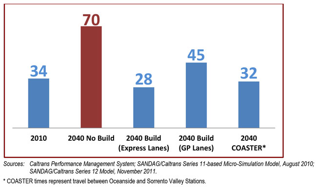
Corridor mean travel times under current and future conditions during peak periods are shown in Table 3B-3. When I-5 is uncongested, it takes 23 -25 minutes to traverse the 27-mile route from La Jolla Village Drive in San Diego to Harbor Drive in Oceanside. This same northbound trip currently takes 34 minutes during the PM peak period and is expected to take a congestion-ridden 70 minutes by 2040 without any improvements to the highway. Even with the planned improvements, travel time in 2040 is projected to be 45 minutes in the general-purpose lanes, indicating that the improvements would not even keep up with projected growth in demand (but would be vastly better than the No-Build condition). In the new Express Lanes, however, PM peak travel would be nearly congestion-free, requiring just 28 minutes. In addition, planned enhancements to the LOSSAN rail corridor would allow the COASTER to make the same trip in 32 minutes in 2040, which would be an improvement of 5 minutes over the No-Build Alternative.
| Time/ Direction | I-5 2010 | I-5 2040 No Build |
I-5 2040 General- Purpose Lanes |
I-5 2040 Express Lanes |
COASTER* 2010 |
COASTER* 2040 No Build |
COASTER* 2040 Improved |
|---|---|---|---|---|---|---|---|
| AM Peak Period Northbound |
23 | 37 | 26 | 24 | 33 | 37 | 32 |
| AM Peak Period Southbound |
36 | 54 | 36 | 24-26 | 33 | 38 | 30 |
| PM Peak Period Northbound |
34 | 70 | 45 | 28 | 33 | 37 | 32 |
| PM Peak Period Southbound |
34 | 40 | 30 | 24-25 | 33 | 38 | 30 |
Note:
The primary transportation analysis and forecasting tool that is used in the San Diego region is the SANDAG Regional Transportation Model (RTM). The RTM projects future travel demand on the region's transportation system by analyzing local land use as well as the projected growth in regional demographics such as population, employment, and housing. The Series 11 RTM, which was the basis for SANDAG's 2030 Regional Transportation Plan (RTP), projected regional travel demand to the year 2030 in metrics such as Vehicle Miles Traveled (VMT) and Average Daily Traffic (ADT). The subsequent Series 12 model, used to develop SANDAG's 2050 RTP, projected these data to the year 2050. Additionally, during the NCC planning process that led to the 2010 Draft PWP/TREP, a specialized micro-simulation model based on Series 11 data was developed to provide NCC-specific projections of corridor travel time and congestion for the year 2030.
A comparison of key measures from the Series 11 and Series 12 RTMs indicates that the Series 11 travel demand forecast for the year 2030 is generally equivalent to the updated Series 12 travel demand forecast for the years 2040-2045. In other words, the growth in both population and travel demand that had originally been anticipated by 2030 is now projected to occur at least a decade later than previously forecast.
In terms of regional demographics, projections underlying the Series 11 RTM showed that the region would add approximately 1 million people by 2030. However, the updated projections that contributed to the Series 12 RTM show that this growth will now occur around 2040.
In terms of travel demand, both VMT and ADT show similar patterns. The figure below demonstrates that the Series 11 regional VMT projection for 2030 is roughly equivalent to the Series 12 regional VMT projection for 2045.
Additionally, the ADT comparison below indicates that, at points along I-5 throughout the NCC, Series 12 projected ADT for 2040 is slightly lower than, or generally equivalent to, Series 11 projected ADT for 2030. (Series 12 projected ADT for 2050 is slightly higher than the 2040 projections, reflecting some growth beyond 2040.)
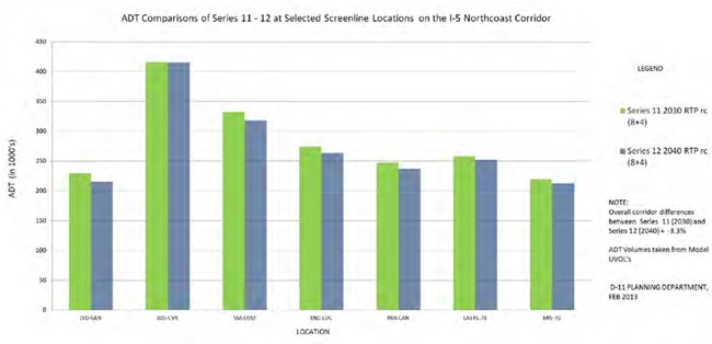
As a result of this comparison of regional population and travel demand between Series 11 and Series 12, it can be reasonably concluded that the 2030 travel time and congestion forecasts developed for the NCC under the Series 11-based micro-simulation model are valid forecasts for 2040 for the corridor, and therefore these two metrics are presented as 2040 forecasts in the PWP/TREP.
Figure 3B-1 is a graphical depiction of the projected travel times during the PM peak period in the northbound direction.
Far from simply benefiting highway drivers, Express Lanes in the NCC would provide benefits to the entire corridor's transportation system, including:
- Faster Travel Times - An Express Lane trip through the entire corridor is projected to be 17 minutes faster in the afternoon peak period than a trip on the general-purpose lanes in 2040.
- Reliable Travel Times - Because the price for SOVs increases as traffic volumes on the Express Lanes increase, the lanes are managed to guarantee free-flow travel for HOVs, resulting in predictable and reliable travel for Express Lane trips.
- Expanded Highway Capacity - At capacity, Express Lanes are expected to carry nearly 4,300 people per hour during peak periods, compared to approximately 2,600 people per hour in a general-purpose lane, providing an efficient approach for expanding the capacity of the highway (moving people vs. cars).10
- Future Transit Infrastructure - Free-flow lanes are essential to the success of transit services like BRT and highway express buses. Express Lanes on I-5, similar in concept to those already constructed on I-15, would provide the necessary facility for these future routes.
- Source of Revenue - In accordance with Senate Bill (SB) 468, revenues from paying SOV users of the Express Lanes (in excess of administrative and operating costs) will be used in the I-5 corridor for the improvement of HOV facilities and transit services.
- Flexibility - The ability to manage the use and vehicle composition of Express Lanes provides great flexibility for changing the way they are used in the future. Changes could respond to shifts in technology, land use, travel patterns, travel demand, economic conditions, and other travel characteristics; changes could include requiring higher vehicle occupancy and greater use of transit, or creating a truck route during certain times of the day.
Although Caltrans recently extended the I-5 HOV lane (one in each direction) north to Lomas Santa Fe Drive/Manchester Avenue, most of the corridor does not have HOV facilities. SANDAG and Caltrans envision four Express Lanes for the NCC-two in each direction. The Express Lanes would be in the median of the highway, accessible at designated points from general-purpose lanes and via DARs from arterial streets at key locations. DARs would provide priority, unimpeded access to Express Lanes to further encourage carpool and transit use. To complement the Express Lanes, the following operational improvements are being considered for the highway corridor:
- Operationally improving general-purpose lanes at 13 locations through the addition of auxiliary lanes between on- and off-ramps, as well as various safety improvements.
- Improving traveler information to alert travelers to traffic conditions so that they can make informed decisions about routes and time of travel.
- Managing and integrating systems, including interconnecting ramp meters.
3B.1.1.4 Bicycle and Pedestrian Vision
The corridor vision for bicycle and pedestrian routes and trails includes an extensive network that provides access to the beaches, lagoons, open spaces, and coastal communities of the NCC. Local roads cross I-5 at 32 locations within the corridor, and many of these crossings are narrow and unaccommodating for bicycles and pedestrians, inhibiting their access to coastal resources. These limited crossings also reduce bicycle and pedestrian access to the Coastal Rail Trail, a separated facility adjacent to the LOSSAN rail corridor that is being developed throughout the NCC, as well as other regionally significant bicycle and pedestrian routes.
As part of the PWP/TREP planning process, and pursuant to California SB 468, SANDAG and Caltrans undertook a Safe Access to Transit and Coastal Resources (SATCR) study to identify various gaps or barriers within the regional and local bicycle and pedestrian networks that limit bicycle and pedestrian access to transit services and coastal resources in the NCC. The study informed the planning process and resulted in the incorporation of bicycle and pedestrian improvements into the PWP/TREP-particularly improvements across and parallel to the highway and rail corridors to be implemented concurrently with the highway and rail projects. As over-crossings are rebuilt and under-crossings are widened to accommodate the new highway footprint, many existing pedestrian and bicycle facilities would be upgraded and new facilities would be added. Pedestrian and bicycle routes across lagoons would be similarly integrated into highway improvements. Additionally, the LOSSAN rail corridor would benefit from new pedestrian bridges and improved crossings that would provide safe and convenient ways for pedestrians and bicycles to cross the tracks, better connecting communities to the Coastal Rail Trail and area beaches. The SATCR report is included as Appendix A of the PWP/TREP.
Beyond establishing better connections with the Coastal Rail Trail, the PWP/TREP improvements also include completing several segments of the Coastal Rail Trail within the NCC. Caltrans and SANDAG have identified several planned Coastal Rail Trail segments as projects to be included in the PWP/TREP. These projects, which are discussed further in Section 4.4 and Section 5.3, would construct more than 7 miles of the Coastal Rail Trail in the cities of Encinitas and Carlsbad. Where feasible, these Coastal Rail Trail segments would be built concurrently with adjacent track projects in the LOSSAN rail right-of-way.
The full range of bicycle and pedestrian improvements is not limited just to crossings, but also includes streetscape enhancements, trail connections, trailheads, and recreational staging areas. Additionally, the program of improvements would also include the construction of the I-5 North Coast Bike Trail-a new facility running the entire length of the corridor roughly parallel to the highway that would complement the existing Coast Highway, Coastal Rail Trail, and the California Coastal Trail. The trail would consist of both separated and shared bicycle facilities and would be located partially in the Caltrans right-of-way (adjacent to I-5) and partially on adjacent city streets. Caltrans has worked with the local cities to determine the most beneficial alignment for this shared facility.
SANDAG's 2050 RTP contains $2.6 billion for an Active Transportation Program that seeks to improve bicycle and pedestrian facilities across the region, including the NCC. The program includes a Regional Bicycle Plan that encourages the development of a unified bicycle system throughout the San Diego region that serves the diverse needs of bicycle riders by providing connections between activity centers, transit facilities, and regional trail systems. One focus of this plan is to improve bike and pedestrian network connectivity by providing links to the region's major bicycle facilities-including the Coastal Rail Trail as well as the future I-5 North Coast Bike Trail in the NCC. By addressing existing barriers to east-west pedestrian and bicycle travel, the enhancements in the PWP/TREP would help further this regional goal, while simultaneously improving access to coastal resources, LOSSAN rail corridor stations, and other community facilities.
Along the LOSSAN rail corridor, the PWP/TREP includes five new grade-separated crossings for bicycles and pedestrians, plus three additional roadway grade separations that will include bicycle/pedestrian improvements. Along I-5, the PWP/TREP includes replacement over-crossings at 20 locations, a new overcrossing at 1 location, and widened under-crossings at 11 locations-all of which would result in improvements over existing conditions (see Section 4.4 and Section 5.3 for specific project details). Among the 40 locations to receive crossing improvements, and accounting for bicycle and pedestrian facilities separately, the benefits include:
- 27 improved sidewalks over existing conditions.
- 15 new sidewalks or pedestrian crossings where none currently exist.
- 16 improved bicycle facilities over existing conditions.
- 6 new bicycle crossings where none currently exist.11
3B.1.1.5 Other Strategies to Minimize Highway Expansion
SANDAG and Caltrans understand that the region cannot build its way out of congestion and have therefore adopted several strategies to focus on managing demand. Population and travel demand will continue to grow in the NCC with or without highway or transit improvements, and SANDAG's goal is to accommodate the growth in the most efficient way possible, minimizing costs as well as environmental impacts.
I-5 was constructed in the late 1960s and 1970s. In the past 40 years, travel demand in the NCC has increased significantly, but capacity improvements on I-5 have been limited and the footprint of the highway has changed little. Improvements to I-5 in the NCC have included the interchange with the I-805 merge, the addition of HOV lanes in the southern portion of the corridor, and operational improvements such as variable message signs and ramp meters. In the absence of major highway expansion in the corridor, the region has focused on a variety of strategies that work together to manage the growth in demand and address the multiple needs of travelers. Without these ongoing strategies, many more freeway lanes than currently planned would be required to meet future forecasted travel demand. Instead, the ongoing and future approach includes the following major components:
Transportation Demand Management (TDM)
TDM strategies have been and would continue to be an important method to reduce travel demand in the corridor by encouraging the use of the bus, carpooling, and other alternative modes. TDM strategies take advantage of (and help build a customer base for) alternative modes by removing obstacles and providing information and incentives to travelers to make it easy for them to reduce trips, reduce travel at the most congested times, or shift altogether from single-occupant driving.
On a regional level, SANDAG implements TDM through its iCommute program. The program assists commuters by providing free carpool and ride-matching services, a subsidized vanpool program, transit solutions, regional support for bicycling, the Guaranteed Ride Home program for regular transit commuters, and the SchoolPool carpooling program for parents. iCommute also provides free assistance to local businesses, helping them develop and implement customized employee commuter benefit programs that lower costs, increase productivity, and help the environment. iCommute is a cost-effective method for easing traffic congestion and reducing air pollution through managing the demand for area roadways by offering a "gateway" of information, resources, and tools describing regional TDM and commute options online or through SANDAG's 511 regional transportation information program.
In addition to the regionwide emphasis of the iCommute program, the 2050 RTP also requires the development of corridor-specific TDM plans to address the varied needs and demands of the region's distinct corridors and communities. Together, SANDAG and Caltrans have prepared a comprehensive TDM plan for the NCC. The September 2013 NCC Transportation Demand Management Implementation Plan was developed to support the NCC infrastructure and environmental program by reducing SOV trips and encouraging the use of more sustainable modes of travel to alleviate congestion both during construction of NCC rail, transit, highway and roadway projects and over the long term to reduce capacity issues on I-5. As such, the plan seeks to provide a foundation for continued travel behavior changes in the corridor once PWP/TREP construction is complete.
The first phase in the development of this plan was extensive market research and analysis of existing conditions-including all trip markets-through surveys and interviews of employers, commuters, schools, cities, and major institutions to identify the best opportunities for TDM programs and services in the corridor. Based on the market research, customized TDM measures and strategies were developed for the NCC and were tailored to reflect the propensity of NCC residents, commuters and others to shift their modes of travel from SOV to non-SOV alternatives such as transit, walking, cycling, carpooling/vanpooling, and teleworking. Implementation strategies include programs and services geared toward employers, agencies, schools, and commuters, financial incentives to encourage alternative travel behavior, public outreach to corridor residents and institutions, and performance monitoring to measure the program's effectiveness.12
Transportation Systems Management (TSM) and Operational Improvements - TSM is a strategy to increase highway capacity without major capital investment, by enacting various operational improvements that increase system efficiency. These include the construction of new auxiliary lanes on the outside of the freeway that would connect on- and off-ramps and allow for acceleration, deceleration, and merging-often the causes of traffic bottlenecks and congestion. Other improvements include Intelligent Transportation System (ITS) features (such as variable message signs) that provide real-time information for drivers to make informed decisions on travel routes and corridor-wide ramp meters at highway entrances to help regulate the flow of incoming traffic. Various corridor interchange improvements help eliminate or minimize bottlenecks in the transportation system. Additional detection, monitoring, and communications infrastructure would allow for incident response and active management of the highway.
3B.1.2 Coastal Communities Vision
3B.1.2.1 Local Streets and Neighborhood Enhancements
While the deficiencies arising from congestion may be most visible on I-5, the effects are not limited solely to the highway. Highway congestion often causes regional and interregional trips to "spillover" onto local streets, as frustrated travelers exit the highway in search of less-congested routes. This results in through traffic using coastal access routes and local streets in attempts to bypass congestion, which negatively affects the character of these coastal communities as well as access to coastal resources. The improvements in the PWP/TREP are intended to protect community character by alleviating spillover traffic demand within the NCC's coastal communities. In addition, the improvements on I-5 would help support community goals to implement traffic-calming and pedestrian-enhancement measures along Coast Highway. As noted in Section 3A.1.3.3, most of the cities in the corridor are proceeding with "complete streets" projects on Coast Highway, which provide for multimodal use and include automobile-lane reductions, in an effort to slow traffic and enhance the environment for pedestrians and bicyclists. These streetscape projects will promote non-automobile circulation, access to transit and coastal amenities, and quality of life in the corridor. However, they are also likely to divert even more traffic onto I-5, compounding the need for capacity enhancement on the highway.
Finally, the PWP/TREP provides an opportunity to preserve the character of coastal communities through the protection of open space areas and neighborhood enhancement projects. These include new and improved bike routes and pedestrian paths that would not only increase connectivity between neighborhoods but would also enhance community access to and along the coast.
3B.1.2.2 Minimize Energy Consumption and Air Emission
The suite of projects has been developed to respect and enhance the environment; reduce greenhouse gas (GHG) emissions from vehicles and continue to improve air quality in the region, and make transportation investments that result in healthy and sustainable communities.
To comply with SB 375, the California Air Resources Board (CARB) has set regional targets for GHG emissions from passenger cars and light-duty trucks. The projects in the PWP/TREP reduce or eliminate traffic congestion during peak periods of demand, managing the transportation system through measures that maximize the efficiency of the transportation network, and implementing measures designed to reduce GHG emissions and traffic congestion during peak periods of demand. The CARB targets for the San Diego region are a 7% per capita reduction in GHG emissions from passenger cars and light-duty trucks by 2020 and a 13% reduction by 2035 (compared with a 2005 baseline). The region's 2050 RTP/SCS would meet the targets for 2020 and 2035. Implementation of the 2050 RTP and SCS would result in a 14% reduction in emissions by 2020, and a 13% reduction by 2035. Free-flow travel in the NCC would result in fewer exhaust emissions per vehicle than congested traffic. The free-flow condition of the Express Lanes and anticipated congestion reduction (reduced delay) on corridor general-purpose lanes would help reduce emissions per traveler in the corridor. A higher percentage of travel by HOVs would lead to fewer emissions per person-trip and correspondingly fewer GHGs emissions in the corridor.
In addition to contributing to the region's achievement of GHG emission reduction targets identified in the 2050 RTP, the PWP/TREP capitalizes on additional opportunities to minimize energy consumption and reduce emissions by first comprehensively assessing transportation demands of the NCC, and then strategically balancing transportation investments in the NCC's critical transportation corridors to meet those needs. The PWP/TREP includes a smaller set of transportation projects than those included in the 2050 RTP, and is a unique corridor in which infrastructure improvements to the parallel LOSSAN rail and I-5 highway facilities may be planned, phased, and implemented to include expanded and enhanced non-vehicular transportation improvements (bicycle and pedestrian routes) specifically designed to meet the multimodal needs of the NCC while further minimizing vehicle miles traveled and corresponding energy consumption and air emissions.
3B.1.2.3 Facilitate Smart Growth, Multimodal Transportation and Economic Viability and Sustainability
A primary goal of the 2050 RTP is to ensure that the region's transportation system promotes environmental sustainability and fosters efficient development patterns that optimize travel, housing, and employment choices. A guiding theme for the 2050 RTP and SCS is to create communities that are more walkable, transit-oriented, and compact, thereby providing transportation options and lowering GHG emissions, and improving public health. By focusing future development on urban infill and redevelopment and improving accessibility to jobs, housing, education, and recreation opportunities, the region is focused on establishing efficient land use patterns that contribute to reductions in GHG emissions, meeting San Diego's GHG targets, and reducing VMT.
The goal of focusing development and infrastructure improvements in already developed areas is also supported by Coastal Act Section 30250:
(a) New residential, commercial, or industrial development, except as otherwise provided in this division, shall be located within, contiguous with, or in close proximity to, existing developed areas able to accommodate it or, where such areas are not able to accommodate it, in other areas with adequate public services and where it will not have significant adverse effects, either individually or cumulatively, on coastal resources.
The NCC area contains more than a dozen planned and potential Smart Growth areas, including those located at each of the LOSSAN rail corridor stations, with the exception of Sorrento Valley Station. Smart Growth areas consist of higher-density, mixed-use developments that are pedestrian-friendly and transit-oriented. In collaboration with SANDAG, local jurisdiction has committed to focusing projected growth in identified Smart Growth areas to enable SANDAG to coordinate regional transportation infrastructure and services with land use plans to help avoid increased traffic congestion, reduced mobility, and a deteriorating quality of life. SANDAG's sustainability strategy uses transportation investments (or "Smart Growth carrots") to encourage growth and development in urbanized areas and away from open spaces and sensitive environmental resources. Additionally, SANDAG's transit investments attempt to put transit where it is most likely to succeed by focusing effort in areas with land uses that support strong transit ridership. These roadway and transit investments would discourage sprawl by implementing projects in urban and suburban areas and not rural areas. In addition to focusing development away from natural environments and open space, experience and research have found that a higher proportion of trips are made by transit, foot, and bike in these Smart Growth areas.
Regional and corridor economic viability and sustainability also depend on providing and maintaining efficient access to and through the corridor. The NCC is a critical corridor for movement and access for the region's significant tourist and freight economic sectors. Tourism is the second-largest traded sector in San Diego, and the tourism industry plays a vital role in the regional economy. The NCC contains many of the region's primary tourist destinations, including state and local beaches, Legoland, the Del Mar Racetrack and Fairgrounds, local community downtowns, over 9,000 hotel rooms, and many restaurants and other entertainment venues. Over 19 million locals and tourists visited one of the NCC attractions in 2012. In addition, the transportation facilities in the NCC provide the direct conduit to the region's most prominent visitor destinations including downtown San Diego (containing the San Diego Convention Center, the Gaslamp Quarter, Embarcadero, Midway and Maritime Museums, and Petco Park), Balboa Park (with the San Diego Zoo and 16 museums and theaters), Old Town State Park, and Coronado. Multimodal transportation investments in the NCC will reduce travel times and improve accessibility within and through the corridor, supporting and enhancing the tourism economy through increased total visitation to attractions in the NCC from both tourists and residents, and broader positive impacts for the region.
NCC transportation improvements (both rail and highway) are projected to provide similar economic benefits for the regional freight industry due primarily to shipper cost savings resulting from travel-time improvements. While San Diego is a major north-south freight gateway connecting the region and points south to Los Angeles and the rest of California, 92% of freight by volume has one or both trips ends (origin or designation) in San Diego County. The NCC transportation improvements, particularly the I-5 improvements (since trucks move the vast majority of freight in the region), will result in travel-time and cost savings for shippers, which will support and sustain the critical freight sector of the regional economy.
3B.1.3 Water Quality and Sensitive Habitats Vision
The California Coastal Commission has the responsibility to "Protect, conserve, restore, and enhance environmental and human-based resources of the California coast and ocean for environmentally sustainable and prudent use by current and future generations." The beaches, lagoons, state parks, recreational facilities, and other coastal resources in the NCC are regional and statewide assets that shape the character of the natural and built environment along the coast. As residents and the agencies responsible for these resources look toward the future, they desire and are required to protect and enhance these assets and resources for human enjoyment and environmental preservation.
3B.1.3.1 Improve Water Quality
The Coastal Act requires that marine resources be maintained, enhanced, and restored and that special protection be given to areas and species of special biological importance or economic significance. The Coastal Act further requires that the use of marine environments sustain the biological productivity and qualities of coastal waters and streams, and maintain healthy populations of all species and marine organisms. The Coastal Act also mandates that the biological productivity and the quality of coastal waters and streams be maintained and, where feasible, restored through means such as minimizing adverse effects of stormwater runoff, minimizing alteration of natural streams, and by maintaining natural buffer areas that protect riparian habitats.
Every coastal and inland waterbody in the corridor provides benefits in terms of flood relief, and potentially provide Environmentally Sensitive Habitat Areas (ESHA) and other habitats that support threatened and endangered species, migratory birds, fish, large mammals, and many different wildlife species. The PWP/TREP program of improvements, including implementation of a comprehensive REMP (Chapter 6B), provides an opportunity to restore and maintain water quality throughout the corridor's watersheds, which is essential to the protection of these sensitive coastal resources.
3B.1.3.2 Restore Lagoons
Lagoons provide significant benefits in their respective watersheds for flood relief, water quality, and maintenance of ESHAs that support threatened and endangered species, including migratory birds, fish, large mammals, and many different wildlife species. In addition, were associated with major open space and adjacent habitat preservation areas, the corridor lagoons provide critical habitat linkages and wildlife corridors in a coastal region that has experienced rapid population growth and urbanization over the last several decades, resulting in fragmentation of natural habitats. The corridor lagoons also provide exceptional open space and scenic resources, and public recreational resources with trail systems, interpretative areas, wildlife observing opportunities, and, in some cases, wide expansive beach areas where the lagoons meet the Pacific Ocean.
Many of the lagoons have been the subject of past and ongoing restoration programs and significant restoration efforts for San Elijo and Buena Vista Lagoons are currently in the planning phase, with alternatives identified and environmental and technical studies underway. In addition, planning efforts to restore Los Peñasquitos Lagoon has also been initiated. There is the potential to restore tidal circulation in the lagoons as part of the restoration programs being considered, which would significantly improve the ecological health of the lagoons and adjacent areas and, in turn, better support ESHAs, degraded habitats, special-status species, and wildlife. Additionally, optimization studies have been conducted within these lagoon systems, and at Batiquitos Lagoon, to ensure the design of bridge crossings maximizes hydraulic functions, minimizes fill, improves wildlife connectivity and does not preclude any potential future restoration alternative. The lagoon conservancies, resource agencies, the Coastal Commission, and the PWP/TREP place a high priority on progress toward ultimate restoration and long-term maintenance of these and all lagoons in the corridor.
The REMP also includes an endowment component that is intended to increase the capacity for long-term management and sustainability of the Batiquitos and Los Peñasquitos Lagoons and to support stewardship of these resources in perpetuity. This endowment includes funding for the maintenance of lagoon inlets and channels deemed necessary to sustain tidal and fluvial flows and to reduce sedimentation within the lagoons, thereby sustaining ongoing lagoon restoration efforts.
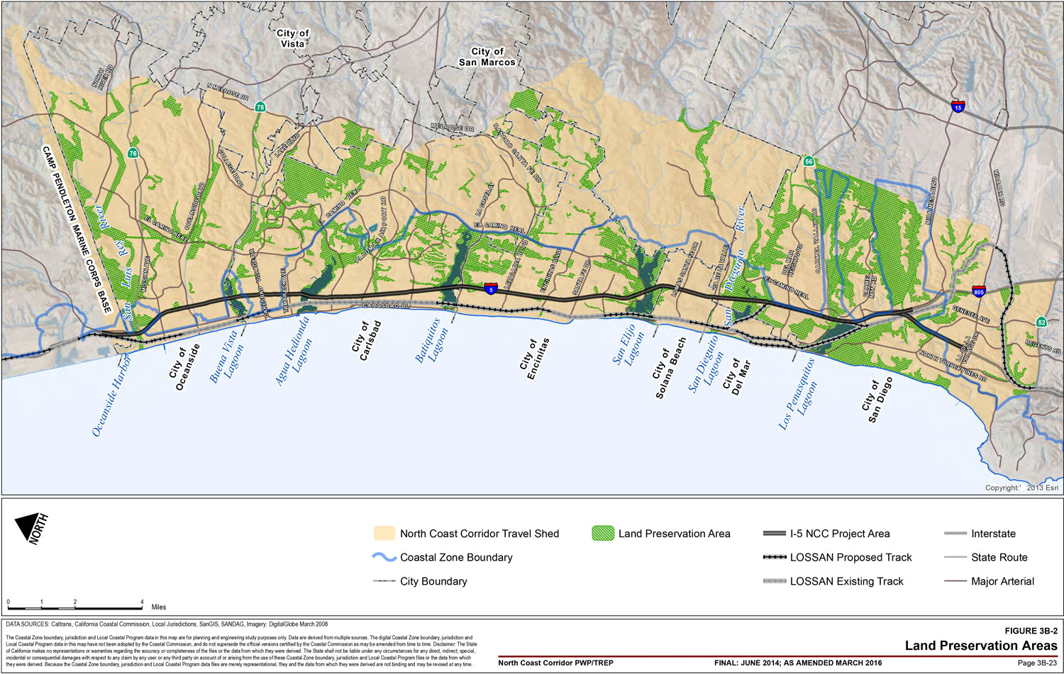
3B.1.3.3 Enhance and Expand Natural Habitats
The Coastal Act requires that ESHAs be protected against significant disruption of habitat values and that proposed development adjacent to ESHAs and parks be designed to prevent adverse impacts to those areas and be compatible with their continuance. Figure 3B-2 highlights the preservation areas designated by SANDAG in the NCC. The program seeks to strategically acquire and preserve ESHAs and degraded habitat areas in conjunction with implementing habitat restoration and establishment opportunities throughout the corridor.
3B.2 Benefits of the Comprehensive Corridor Vision
The implementation of the multimodal vision for the NCC would deliver numerous benefits to the region. These include not just the better performance of the transportation system-which confers mobility and economic benefits to the entire region-but also increased access to coastal areas, protection and restoration of sensitive environmental resources, and improved air quality through reduced emissions.
3B.2.1 Achievement of Transportation and Coastal Access Vision
Broadly speaking, the transportation and coastal access objectives identified in Section 3B.2.1.1 are aimed at increasing regional mobility in ways that respect both the environmental and fiscal implications of transportation projects. The multimodal transportation vision for the NCC is an embodiment of those objectives, with each element of the strategy contributing to the maintenance of an effective and balanced transportation system and enhanced coastal access in the NCC.
Coastal resources in the corridor include the beaches, parks, lagoons, upland trails, and activity and recreational centers such as the Del Mar Fairgrounds and Racetrack. As demand for these resources continues to increase, the corridor improvements in the PWP/TREP would reduce or eliminate access impediments for residents and visitors alike. Both the I-5 highway and LOSSAN rail corridors' projects focus on increasing the efficient movement of people, rather than just vehicles. In addition, bicycle and pedestrian routes that are currently incomplete, not built to current standards or plans, or not available for access to coastal areas in the NCC would be upgraded and/or connected. Facilitating and encouraging non-automobile transportation with new and improved multimodal options would provide access to the coast and recreation areas with alternative modes of transportation (trails, bike paths, and transit). The PWP/TREP projects would add and improve sidewalks and bicycle lanes at highway and rail crossings throughout NCC communities, providing access to coastal amenities including the Coast Highway, the Coastal Rail Trail, and the California Coastal Trail. These projects would effectively eliminate many bicycle and pedestrian barriers, as well as provide enhanced connections with public transit centers, thereby promoting access to transit. This program of improvements will work to fulfill the Coastal Act requirement that coastal access and recreational resources are not simply protected but also enhanced over time.
3B.2.1.1 Ensuring Coastal Access and Recreation
The PWP/TREP would ensure coastal access for both residents and visitors to the corridor's many unique natural resources is maintained and enhanced-a goal that is directly supported by the NCC's transportation objectives.
Congestion Reduction
The Coastal Commission Public Access Action Plan recognizes roadway congestion as one of the greatest impediments to public access in coastal areas and specifically notes that, among other things, traffic congestion and poor traffic circulation are significant problems where residents and visitors compete to use the same transportation system.13 It is for this reason that the San Diego region's past and continuing efforts to reduce traffic congestion and maintain acceptable transportation services on I-5 and local transportation arterials are critical elements to protecting public access to recreational opportunities along the NCC coastline.
This PWP/TREP recognizes that constructing new transportation corridors or new general-purpose lanes to meet travel demand would not solve the highway-capacity deficiency without affecting adjacent communities, lagoons and habitat areas. Therefore, to address the highway-capacity deficiency in the corridor in a way that would provide the most benefit to coastal access and natural resources while meeting regional travel demand, facility improvements are planned to accommodate more travelers (i.e., more people), more efficiently, and with minimal facility expansion (footprint) when compared to other transportation alternatives.
Express Lanes would accommodate future demand on I-5 by getting the most person-carrying capacity out of the least amount of highway footprint expansion, thereby reducing overall congestion on I-5 for all users, protecting and facilitating public access, and minimizing impacts to adjacent communities and sensitive coastal resources. As discussed in the following sections, Express Lanes would also enable new and expanded public transportation opportunities in the NCC by prioritizing and ensuring reliable travel for buses and other HOVs. In addition, both I-5 highway and LOSSAN rail infrastructure improvements would provide new opportunities to enhance pedestrian and bicycle coastal access facilities-all of which would provide alternative means of coastal access in the NCC and further reduce demand on I-5.
Maintenance and Expansion of Transit Service
Proposed PWP/TREP improvements for the LOSSAN corridor would contribute substantially to enhancing mobility throughout the NCC by increasing and improving rail service, providing new rail service at the Del Mar Racetrack and Fairgrounds, and supplementing parking supply at, adjacent to, or in close proximity to rail stations for new customers. The proposed Del Mar Fairgrounds Special Event Platform-currently planned to operate intermittently, during periods of high demand-would provide new access opportunities to the beach, San Dieguito River Park, and Del Mar Racetrack and Fairgrounds, which is one of the region's most popular tourist destinations. Planned access improvements to rail stations also include pedestrian and bicycle access.
The NCC does not currently have BRT service. Implementation of this type of transit improvement is planned in the corridor over the next 40 years, with successful BRT wholly dependent upon the implementation of the I-5 Express Lanes. The BRT planned for the I-5 Express Lanes would target the peak-period commute trip between the high-density Mid-City residential area in central San Diego and the Palomar Airport Road business park in the NCC. As with planned rail service improvements, BRT would serve to relieve congestion and reserve capacity on I-5 for other users, including visitors and recreational travelers who are not easily served with transit. In addition, improvements to local bus service are planned for the NCC, including along Coast Highway. The planned Coast Highway improvements would incrementally implement rapid bus features in coordination with planned multimodal improvements along Coast Highway by corridor cities. Planned bus transit improvements in the NCC would provide more service frequency, better access to coastal resources and rail transit, and infrastructure enhancements to facilitate transit operations and promote transit ridership among residents and visitors alike.
Provisions for Non-Automobile Circulation
The Coastal Act recognizes the necessity and benefit of providing varied transportation choices for all people, including alternative transportation modes that are not reliant on the automobile. These choices include not only transit but also active transportation modes such as walking and biking. Well-planned, non-motorized transportation networks can bridge the gap between origins or destinations and the transit system, addressing the classic "last mile" problem for transit users. In addition, pedestrian and bike facilities create attractive transportation links between land uses that draw travelers out of their automobiles when making short, local trips and when seeking access to coastal resources. Providing pedestrian and bicycle access to the shoreline and upland recreation areas is one of the highest priorities of the Coastal Act.
A fundamental element of the PWP/TREP is that it would improve bicycle and pedestrian routes and trails, which would enhance the network and provide access to the NCC's transit stations, beaches, lagoons, open spaces, and coastal communities. Existing fragmented access routes and trails of the network would be upgraded and completed, eliminating barriers and gaps to provide safe, non-automobile circulation to and from coastal recreation areas while creating new recreational opportunities.
Beneficial impacts to coastal access and recreation would also result from highway and rail improvements that include reconstructing under- and overpasses to better connect and improve bicycle and pedestrian access routes to the coast. These improvements would address travel-user separations to provide a more comfortable travel environment for pedestrians and bicyclists to further encourage these modes of travel across I-5 between inland and coastal areas, and in some locations would provide connections to regional bicycle facilities.
Adequate Parking
The presence of adequate parking facilities in coastal areas to serve residents, commercial uses and visitors who travel by car is an important variable that influences public access and recreation opportunities in the Coastal Zone. Transit services must be supported by ample parking, walking, and bicycle facilities to ensure maximum accessibility of the NCC's coastal resources via alternative modes of travel. In addition, as the majority of rail stations in the NCC are located just blocks from the beach, constrained parking resources could result in overflow parking by train passengers onto adjacent streets, which could displace parking resources used by people to access the coast by automobile. However, where adequate parking supply does occur, these parking resources support access to nearby beaches and recreation areas. Proposed PWP/TREP improvements include expanding parking areas at, adjacent to, or in close proximity to the corridor's transit stations, which would support passenger rail service and reduce the possibility of conflicts between rail passenger and coastal access parking resources on adjacent streets. Furthermore, PWP/TREP improvements include the construction of new and enhanced staging areas for bike and trail facilities throughout the corridor. These improvements would increase access to and use of the NCC's recreational facilities.
Access to Natural Resources and Recreational Facilities
The improvements described above would not just improve travel choices, but also substantially enhance recreational opportunities in the corridor by completing linkages between communities, inland and coastal areas, and providing access opportunities to the NCC's regionally significant natural resource and recreation areas.
The corridor's most significant natural resource areas (such as the corridor's beaches and six coastal lagoons) support some of the region's most significant passive and active coastal recreational opportunities for San Diego residents and visitors.
When considering the unique needs and travel patterns of visitors and recreational travelers in the corridor, which are not easily served with transit, the region's past and continuing efforts to reduce traffic congestion and maintain acceptable transportation services on I-5 and local transportation arterials are critical elements to protecting public access to recreational opportunities along the San Diego County coastline. Proposed PWP/TREP improvements are necessary for maintaining and enhancing public access to the corridor's coastal areas by extending and improving transit service, reducing transportation congestion-particularly for the variety of coastal users in the corridor-providing adequate public transportation and non-automobile circulation that support access to coastal recreational areas, and providing and/or enhancing recreational facilities.
As detailed in Section 5.3, rail improvements that increase capacity, reduce travel time, increase reliability, and provide new service area opportunities, such as those proposed, are major contributors to protecting and enhancing access to the coast. Furthermore, as the primary means for the public to reach shoreline access points and recreational destinations in the corridor, I-5 serves as the gateway to the entire San Diego coastal area and provides a unique scenic recreational traveling experience. As travel demand in the I-5 highway corridor continues to increase, so does the existing coastal access impediment of traffic congestion. Proposed PWP/TREP improvements focusing on HOV/Express Lanes would give priority to ride-sharing, public transit and-when capacity allows-SOVs via a variable price while reducing overall congestion and facilitating public access on San Diego's primary transportation facilities. The proposed PWP/TREP would ensure that the corridor's large and varying customer base of HOVs (many of which are seeking access to coastal resources) would be provided with uncongested, reliable travel times.
PWP/TREP improvements for bicycle and pedestrian routes and trails would enhance an extensive network that provides access to the corridor's beaches, lagoons, open spaces, and coastal communities. In addition, the PWP/TREP establishes and constructs significant portions of a new I-5 North Coast Bike Trail-a continuous, non-motorized access trail running the length of the highway corridor that would complement the existing Coast Highway, Coastal Rail Trail, and California Coastal Trail. In addition, nearly 7 miles of the long-planned Coastal Rail Trail would be constructed within the LOSSAN rail right-of-way.
The addition of Express Lanes on I-5 includes the reconstruction of under- and overpasses-most of which would include enhancements to bicycle and pedestrian facilities that would address barriers and improve connections to bicycle and pedestrian routes to the coast, including routes across lagoon systems. Additionally, the LOSSAN rail corridor would benefit from new pedestrian bridges and improved crossings that would provide safe and convenient ways for pedestrians and bicycles to cross the tracks, better connecting communities to the Coastal Rail Trail, California Coastal Trail, and area beaches. These access improvements would serve to meet a primary goal articulated in the state-mandated, Coastal Commission-supported Completing the California Coastal Trail report: "Create linkages to other trail systems and to units of the State Park system, and use the Coastal Trail system to increase accessibility to coastal resources from urban population centers."14 PWP/TREP implementation would provide and connect several threads within the Coastal Trail system between inland and coastal communities, allowing the public to more easily access shoreline, lagoons and upland recreation resources.
Considering the significant alternative transportation options planned for the NCC, the PWP/TREP would maximize public access and recreational opportunities throughout the corridor consistent with public safety needs by:
- Improving public transportation infrastructure to support more frequent, attractive, and reliable rail, BRT and rapid bus service, resulting in increased transit ridership and reduced traffic congestion that would otherwise adversely affect the ability of the public to reach the coast along this primary coastal access corridor.
- Improving and integrating transit services with other non-automobile modes of travel within the corridor to increase ridership and reduce traffic congestion that would otherwise adversely affect public coastal access.
- Facilitating and encouraging non-automobile transportation with new and improved multimodal improvements that would provide access to the coast and recreation areas with alternative modes of transportation (trails, bike paths, and transit). The PWP/TREP projects would add and improve sidewalks and bicycle lanes at many highway and rail crossings throughout NCC communities, providing access to coastal amenities including the Coast Highway, the Coastal Rail Trail, and the California Coastal Trail. These projects would effectively eliminate east-west bicycle and pedestrian barriers along the highway and rail corridors, and provide enhanced connections to the bicycle and pedestrian networks and public transit centers, thereby promoting access to transit.
- Creating and constructing a new, corridor-long I-5 North Coast Bike Trail and constructing several missing links of the Coastal Rail Trail.
- Enhancing and providing bike and trail staging areas, including support facilities such as parking, which would be distributed throughout the corridor.
- Creating and enhancing pedestrian access to other natural resources, including lagoons and adjacent upland areas via trail and bicycle improvements throughout the corridor.
3B.2.1.2 Congestion Reduction
As discussed in Section 3.1.2, the NCC's transportation facilities today are plagued by congestion. From the peak-period backups along I-5 to the single-track delays on the LOSSAN rail corridor, the NCC represents a bottleneck not just for the San Diego region but also for the state and national transportation systems. Regular periods of congestion directly result in lost time and lost money and access-for residents, commuters, and visitors. Bottlenecks on the highway and rail corridors also impede the efficient movement of goods in and through the region, including the economically vital connections to Mexico and the Port of San Diego, resulting in longer shipping times, higher product costs, and economic losses for the entire society. On I-5, these bottlenecks also spill into the local road network in the form of "cut-through" traffic, which congests local communities. Finally, congestion diminishes air quality throughout the corridor as vehicles are forced to operate at inefficient speeds in stop-and-go settings.
Highway improvements, however, are only one element of the multimodal solution envisioned by the PWP/TREP. The PWP/TREP also includes LOSSAN rail corridor double-tracking, COASTER service improvements, new rapid bus, and BRT services, enhanced local bus service, and greatly improved facilities for bicycles and pedestrians. Each improvement is aimed at increasing capacity in some way and, taken together, they represent a balanced approach to addressing the corridor's mobility and access problems. The fulfillment of the PWP/TREP's multimodal transportation vision would go a long way toward increasing corridor capacity, decreasing congestion, and providing faster, more reliable travel choices for the residents, visitors and businesses who use the NCC's transportation system to access homes, jobs, shopping, recreational venues, and coastal resources.
3B.2.1.3 Transportation Flexibility
While population growth in the NCC is expected over the next 40 years, other unforeseen changes may also occur that alter the mobility needs of the corridor's residents and visitors. Whether it is variations in travel patterns, modifications to land use policy, or advancements in technology, the transportation system should be equipped to respond to these changes as they happen. Caltrans and SANDAG understand that the current high level of demand for automobile travel may not persist forever- particularly as regional congestion and fuel costs increase-and this is why they have chosen a program of multimodal improvements for the NCC.
The Express Lanes on I-5, for example, would not just allow more efficient automobile travel in the corridor, but would also serve as an essential enabler of future transit services, by providing a congestion-free path for express buses or BRT. The ability to manage these new, separated highway lanes to meet changing travel behavior and demand-by variable pricing when capacity allows, changing vehicle occupancy requirements, or even creating a truck route during certain times of day-guarantees that there would always be free-flow access to coastal resources and communities. The 2050 RTP already includes plans for a reverse-commute BRT that would utilize I-5, traveling from San Diego's Mid-City neighborhoods north to the business park near Palomar Airport Road in Carlsbad. The existence of Express Lanes would allow additional BRT service to be added in the future when demands dictate. Similarly, the planned LOSSAN rail corridor enhancements would allow for much greater capacity on the rail corridor than is needed today, ensuring that the rail infrastructure would be able to accommodate demand growth for many decades into the future.
3B.2.1.4 Value Maximization
The competing demands for the region's limited transportation funds require SANDAG to select projects using a rigorous evaluation of goals, priorities, and projections during the regional planning process. As discussed in Chapter 2, the 2050 RTP seeks to maximize the efficiency and effectiveness of transportation investments, and its prioritization of projects reflects this goal. While a basic level of funding is provided to all areas, the 2050 RTP's major investments focus where they are most likely to succeed; in the denser urban areas of the region, this often means a greater emphasis on transit services, while in the outlying, more suburban areas, this might mean a higher proportion of new highway projects or improved local arterials.
This PWP/TREP contains a combination of transportation investments that improve the transportation system's efficiency by favoring the implementation of high-capacity transit and highway facilities over expansion for single-occupancy autos. And because these facilities would offer fast and reliable travel choices for a variety of travelers to, through, and within the NCC, they are projected to attract sufficient use to maximize the value of the investments. While a transportation "wish list" for the NCC-one that is unconstrained by fiscal or legislative requirements-might contain even larger investments in transit, the corridor's demographics, employment, land use, geography, and travel pattern characteristics limit both the viability and cost-effectiveness of more significant investments in transit (Section 3A.1.2). The proposed projects for the NCC would greatly improve corridor mobility and access while balancing both the corridor and regional need to maximize the benefits per dollar spent.
3B.2.1.5 Integration into Larger System
The NCC is not an isolated corridor, but rather one piece in a much larger network of regional, state, and national transportation facilities. As a federally designated "Corridor of the Future," I-5 is an economically significant resource that plays a nationally significant role in the movement of people and goods. Similarly, LOSSAN is the nation's second-busiest passenger rail corridor as well as a significant freight facility. Considering the roles that these NCC facilities play in the national economy, it is clear that local congestion is not simply a local problem; such deficiencies create impacts that are felt well beyond the San Diego region.
It is, therefore, critical to ensure that the NCC's transportation infrastructure is maintained as an effective link in the national transportation system. The facilities must minimize congestion, remain in good repair, and take advantage of technological and operational advancements to increase efficiency. This PWP/TREP accomplishes these goals by providing NCC facilities with their first major overhaul in decades, expanding the capacity of both the I-5 highway and LOSSAN rail corridors to accommodate new demand. In addition, this program features a wide range of repairs and enhancements-including grade separations, signal improvements, DARs, auxiliary lanes, and rail bridge replacements-that would increase throughput efficiency and help preserve the facilities for the long term. This program would allow the NCC to maintain its crucial role as an important link in the larger transportation network and ensure that degradation of NCC transportation facilities does not become the weak link in regional and interregional access to the coast.
3B.2.1.6 Movement of People Rather than Vehicles
The efficiency of a transportation system can be measured by the mobility benefits it provides in relation to its costs. Because each vehicle on a highway contributes to congestion, maximum efficiency is achieved when every vehicle is carrying the greatest amount of people or goods possible. While this is not a realistic scenario for all travelers-circumstances often require travel in SOV-high-occupancy travel is still something that can be encouraged with incentives. Express Lanes are one such incentive since they offer travelers a choice: Either travel alone and risk delays, or carpool and bypass congestion. It is in this way that Express Lanes prioritize the movement of people over the movement of vehicles, thus achieving both better mobility and higher capacity per dollar spent. As noted above, during peak conditions one Express Lane is able to carry nearly 70% more people than one general-purpose lane.15 This confers a clear benefit to the region by achieving greater mobility outcomes per dollar spent than a traditional, general-purpose lane highway expansion. Transit investments bring similar benefits by encouraging travelers to ride in high-occupancy trains or buses when it fits their travel needs. By focusing investments in the NCC on high-occupancy transit and Express Lane facilities, these projects would enable more efficient coastal access for many more people well into the future than would otherwise be possible under current conditions.
Prioritizing the movement of people over vehicles also contributes to environmental goals, since high-occupancy travel produces fewer GHG emissions per capita than single-occupancy trips. SANDAG is required by state law to meet GHG reduction targets, and the addition of Express Lanes to regional highways is a key component of the agency's strategy to achieve this. Similarly, the planned enhancements to the LOSSAN rail corridor would reap both mobility and environmental benefits by providing a better level of service that would encourage some travelers to ride the COASTER instead of driving alone. The efficient movement of people in the coastal corridor would enhance air quality along the coast and positively contribute to regional GHG reductions.
Table 3B-4 depicts the types of travelers who would benefit from the planned transportation improvements (separated by each transportation facility in the NCC).
| Type of Traveler | COASTER | Inter-regional Rail | I-5 Express Lanes | I-5 General- purpose lanes |
Coast highway enhanced bus |
Local Bus | Bike & Pedestrian |
|---|---|---|---|---|---|---|---|
| Residents Short (less than 5 miles) | Primary Trip Mode | Primary Trip Mode | Primary Trip Mode | Primary Trip Mode | |||
| Residents Medium (5-30 miles) | Primary Trip Mode | Primary Trip Mode | Primary Trip Mode | Primary Trip Mode | Primary Trip Mode | Primary Trip Mode | |
| Commuters Short (less than 5 miles) | Primary Trip Mode | Primary Trip Mode | Primary Trip Mode | Primary Trip Mode | |||
| Commuters Medium (5-30 miles) | Primary Trip Mode | Primary Trip Mode | Primary Trip Mode | Primary Trip Mode | Primary Trip Mode | Primary Trip Mode | |
| Commuters Long (more than 30 miles) | Primary Trip Mode | Primary Trip Mode | Primary Trip Mode | Primary Trip Mode | Secondary Trip Mode | ||
| Visitors Medium (5-30 miles) | Primary Trip Mode | Primary Trip Mode | Primary Trip Mode | Primary Trip Mode | Secondary Trip Mode | Secondary Trip Mode | Secondary Trip Mode |
| Visitors Long (more than 30 miles) | Primary Trip Mode | Primary Trip Mode | Primary Trip Mode | Primary Trip Mode | Secondary Trip Mode | Secondary Trip Mode | Secondary Trip Mode |
| Businesses Short (less than 5 miles) | Primary Trip Mode | Primary Trip Mode | |||||
| Businesses Medium (5-30 miles) | Primary Trip Mode | Primary Trip Mode | Primary Trip Mode | ||||
| Interregional & Through Travelers Medium (5-30 miles) |
Primary Trip Mode | Primary Trip Mode | Primary Trip Mode | ||||
| Interregional & Through Travelers Long (more than 30 miles) |
Primary Trip Mode | Primary Trip Mode | Primary Trip Mode |
3B.2.1.7 Environmental Protection and Enhancement
The multimodal vision would protect and enhance local communities and facilitate Smart Growth and would reap environmental benefits through improved air quality, which would result from increased HOV travel as well as fewer vehicles operating in the inefficient, stop-and-go patterns of congestion. SANDAG is mandated by state law to reduce per capita GHG emissions by 2035, and the agency plans to achieve this through increases in both HOV travel and transit ridership. The PWP/TREP's investments in Express Lanes, LOSSAN rail corridor improvements, and transit service enhancements would directly contribute to these objectives and are key components of SANDAG's overall strategy to meet the legal mandate. In addition, Caltrans is developing a plan to incorporate state-of-the-art rapid electric vehicle (EV) charging stations at all NCC park-and-ride facilities. Charging terminals for EVs would provide convenience to current users and act as an incentive for increased use of EVs in the future, potentially reducing GHG emissions associated with vehicle travel.
While the LOSSAN rail improvements and the addition of Express Lanes to I-5 would expand the transportation footprint within the Coastal Zone, SANDAG and Caltrans have selected the smallest-footprint highway alternative-8 existing general-purpose lanes plus 4 new Express Lanes separated by a buffer (8+4 with buffer)-from among the various expansion options considered for the corridor. Furthermore, the concurrent REMP, which is financially and legally tied to the implementation of the corridor transportation projects, ensures that significant contributions are made to the enhancement and protection of the NCC's environmental resources. The package of improvements planned for the NCC includes not just highway, rail, bicycle, and pedestrian enhancements, but also wetland and upland establishment, restoration, enhancement and preservation, lagoon bridge optimization, and the improvement of coastal trails and habitat areas. By taking advantage of TransNet transportation funding that would otherwise be unavailable for these purposes, the REMP ensures that the NCC's natural environment would benefit from the planned transportation improvements.
3B.2.2 Achievement of Coastal Communities Vision
The program of improvements in the PWP/TREP would make major contributions to the fulfillment of the NCC's coastal resource objectives and as well as the requirements of the Coastal Act.
3B.2.2.1 Local Streets and Neighborhood Enhancements
With the continued increase in population and travel demand, the future promises increased levels of congestion in the NCC unless capacity improvements are made. The multimodal vision described in this chapter outlines a wide range of transportation improvements planned throughout the corridor to address the growing travel demand. The addition of Express Lanes to I-5 is one element of this solution, which would expand the highway's capacity for high-occupancy and transit vehicles. Reduced traffic congestion on I-5 would alleviate the pressure of local communities to address and accommodate "cut-through" traffic on Coast Highway and other arterial streets that may otherwise be affected as highway travelers search for alternate routes. Maintaining access along the I-5 corridor would also maintain access along the various local coastal transportation corridors in the NCC, ensuring spillover travel demand from I-5 would not affect local communities or precipitate improvements on local arterials that could affect the NCC's sensitive coastal resources.
In addition, the PWP/TREP includes community enhancement projects that consist of developing and/or enhancing community parks, protecting open space and habitat restoration, and constructing new and improved pedestrian and bicycle trails, mini-parks, enhanced view corridors, and improved scenic vista points within the NCC cities. These improvements would protect and enhance coastal community character (through sensitive design) while improving travel choices by creating and completing linkages between communities, inland, and coastal areas, and enhancing access opportunities to the corridor's regionally significant natural resource and recreation areas. Again, funding for these improvements would be unavailable absent their connection to the highway funding made available by way of the TransNet ordinance.
Finally, the PWP/TREP provides unique opportunities to preserve the coastal character of the corridor, which is largely defined by the natural open space areas associated with the NCC lagoons. The PWP/TREP includes acquisition, preservation, and restoration of lands within and adjacent to the lagoon systems, resulting in the parallel benefits of preserving visual open space for public enjoyment and protecting and enhancing natural resources. The PWP/TREP bicycle and pedestrian trail improvements would further provide new opportunities for the public to access to the NCC's significant open space areas for passive recreation and extensive coastal resource viewing opportunities, including views to and along the coastline and within the corridor's large open space and natural resource areas. In this regard, the PWP/TREP would contribute to and expand the corridor's visual open space resources, while providing continuous public viewing opportunities of the corridor's most significant natural features.
In addition, Caltrans has worked with the NCC communities to develop a set of Design Guidelines which are included in the PWP/TREP. The I-5 NCC Project Design Guidelines (Appendix C of the PWP/TREP) include corridor-wide and local design themes to preserve the natural and community visual characteristics of the existing corridor and create a unifying visual thread. These guidelines would protect coastal views, incorporate community and regional identity into architectural features, native planting.
3B.2.2.2 Minimizing Energy Consumption and Air Emissions
Among the fundamental purposes of the PWP/TREP is extending transit service and providing the infrastructure needed to facilitate new transit service and Smart Growth, to reduce congestion on the existing transportation system and provide and improve multimodal transportation in the corridor. These improvements would inherently serve to minimize energy consumption and air emissions, while protecting, promoting and enhancing a variety of public access and recreational resources in the corridor as mandated by the Coastal Act. In addition, cleaner fuels and new vehicle technologies would help reduce the majority of smog-forming, criteria pollutants. Regional air quality is expected to improve from advances in-vehicle technology and the implementation of the NCC and 2050 RTP transportation improvements.
The suite of NCC transportation improvements is an integral component of the 2050 RTP transportation infrastructure, which would collectively reduce congestion for autos, trucks, and public transit. At the regional scale, the percentage of peak-period auto travel occurring during congested periods is projected to drop from 27.7% under the No-Build Alternative to 17.2% with the implementation of the 2050 RTP transportation system improvement. Similarly, congested conditions for peak-period transit travel are projected to drop by nearly half (from 9.1% to 5.1%). The number of hours of delay per day for trucks is projected to decrease from 32,300 hours to 16,000 hours with the implementation of the 2050 RTP.16
As detailed in Section 5.1, despite the increase in VMT projected on I-5 under the Build Alternative, corridor project improvements are projected to reduce congestion and lead to decreases in both vehicle hours traveled (VHT) and vehicle hours of delay (VHD) on I-5, as well as decreases in VMT and average daily traffic (ADT) on parallel arterials Coast Highway and El Camino Real, between the No, and Build Alternatives. All of these factors would positively influence congestion-related vehicle emissions in the corridor, and would help to offset the projected increase of 4.0 -9.9% in VMT on I-5 between the No Build and Build Alternatives .17 Specifically, implementation of the project would provide the following transportation improvements that would lead to energy and air quality-related benefits when compared to the No Build Alternative:
- A reduction of 25-35% in peak-period corridor travel times on I-5 (Table 3B-3).
- A reduction of 4% in VHT on I-5.18
- A reduction of 47% in VHD on I-5.19
- Reductions of 17% and 10% in VMT on Coast Highway and El Camino Real, respectively.20
- Reductions of 12% and 3% in ADT on Coast Highway and El Camino Real, respectively.21
- A decrease in the duration of daily peak-period congestion on I-5 from a range of 12 to 13 hours to a range of 5 to 6 hours. 22
In addition, with the unique opportunity to assess, plan and implement a variety of multimodal transportation enhancements in conjunction with improving the NCC's primary LOSSAN rail and I-5 highway transportation corridors, the PWP/TREP would also provide alternative transportation options (such as transit, HOV facilities, BRT options, pedestrian trails, and bike paths) that efficiently and effectively accommodate more person trips in the corridor while minimizing energy, air quality and GHG impacts, particularly impacts per person-trip. The PWP/TREP improvements would reduce vehicle travel in several ways, including shifting from driving to other modes (e.g., rail, BRT, bicycling, walking), increasing vehicle occupancy (e.g., HOV/Express Lanes), and reducing vehicle trip lengths (e.g., park-and-ride facilities). These strategies to reduce VMT would generally also reduce vehicle-generated emissions of criteria pollutants and GHGs. Each mile that a vehicle travels, it emits more pollution; therefore, as the project reduces growth in vehicle travel mileage it would also reduce air pollutant and GHG emissions compared to the No-Build Alternative. Technology improvements-such as ITS, electronic communications, and incident response systems-would further improve corridor efficiency and reduce congestion and idling. In general, by reducing motor vehicle idling and vehicles operating at inefficient stop-and-go speeds, the PWP/TREP would reduce vehicle air pollutant emissions. As such, though a minor increase in VMT is projected on I-5 under the Build Alternative, the long-term savings in operational energy requirements-from reduced congestion-related fuel consumption, out-of-direction travel, higher vehicle occupancy, and more trips made by walking and biking-would offset construction energy requirements and thereby minimize air emissions.
Collectively, proposed transportation improvements would reduce traffic congestion and encourage alternative modes of travel to SOVs, which would lead to more efficient use of fuel, reduced idling times, and would result in associated and corresponding energy consumption and air pollutant emission reductions. Transportation-related GHG emissions are in large part determined by the sum of individual travel choices, as well as other important factors like land-use patterns and vehicle fuel efficiency. Additional Express Lanes, new and expanded park-and-ride facilities, improved bicycle, and pedestrian features, ramp metering, and an improved transit-highway interface would be anticipated to improve traffic conditions and encourage alternative transportation modes, and thus reduce energy consumption, as more people carpool or choose other modal options. By accommodating current and projected growth in traffic demand in the existing transportation corridor, indirect and inefficient routing on parallel roads would be reduced. Finally, the PWP/TREP includes a program of multimodal transportation enhancements including trails, bike paths, and pedestrian improvements that would facilitate non-motorized circulation across the transportation facilities throughout the corridor.
The Coastal Act, as well as SB 468, recognizes the benefits of providing transportation choices for all people, not only to facilitate coastal access and recreation, but also as a means of reducing VMT, energy consumption, and GHG emissions, and thus curtailing the effects of global climate change. While the implementation of Coastal Act policies is limited to addressing development activities affecting coastal resources in the Coastal Zone, climate change is a coastal resource issue driven by land use and transportation activities that extend well beyond the boundaries of the NCC and the region. In this regard, Coastal Act policies that address reducing VMT and energy consumption by providing transit in the Coastal Zone are supported by the region's transportation objectives. These objectives are aimed at ensuring that the transit component of the NCC's transportation system is effectively integrated into the regional, state, and national systems and that transportation investment in the NCC complement the region's commitment to provide the greatest possible mobility project benefits per investment.
Investing available funds in transportation improvements that would support transportation solutions across jurisdictional boundaries and that would facilitate Smart Growth practices that maximize mobility at the regional level, is the best means of reducing VMT and energy consumption in the region to help achieve state-mandated GHG reductions, and thus support efforts to address the effects of global climate change on coastal resources.
Accordingly, implementation of the proposed PWP/TREP would be consistent with the regional plans developed to improve energy efficiency and reduce air quality and GHG emissions. The PWP/TREP's investments in LOSSAN rail improvements, Express Lanes, transit service and non-motorized travel directly contribute to regional GHG reduction objectives and are key components of SANDAG's overall strategy to achieve compliance with SB 375 as well as compliance with SB 468.
3B.2.2.3 Facilitating Smart Growth, Multimodal Transportation, and Economic Viability and Sustainability
While corridor population and travel are expected to increase over the next 30 years, this growth will occur regardless of whether the PWP/TREP program improvements are implemented.23 Transportation infrastructure improvements proposed by the PWP/TREP would support new and expanded transit services and would improve multimodal travel options, which would facilitate the region's Smart Growth efforts in the corridor. In addition, the NCC multimodal transportation program, including both rail and highway improvements, would support corridor and regional economic viability and sustainability by improving mobility and access for two key economic sectors: tourism and freight.
Smart Growth
Planned Smart Growth areas in the NCC would go a long way toward concentrating populations near rail stations but would be unable to transform the existing, much more far-reaching land use patterns into a broader transit-supportive environment, which would require a tripling of residential densities and redeveloping communities throughout the NCC and Coastal Zone with more walkable, grid-like, better-connected local street networks. However, Smart Growth is the most sustainable means of accommodating future growth in the NCC, and the 2050 RTP includes significant investment in LOSSAN rail, BRT, and enhanced local bus service in the corridor to accommodate this growth near stations and along transit routes.
As detailed in Section 5.2, both the proposed rail and highway projects would increase travel capacity in the corridor, thereby reducing travel times and improving the quality of service. Focusing investment on facilities that encourage alternative modes of transportation-such as improving the existing LOSSAN rail corridor, introducing Express Lanes on I-5 that allow for express buses, BRT and HOVs, and developing bicycle lanes, sidewalks and trails-would assist in concentrating future growth into identified Smart Growth and other urban areas where corresponding travel demand can be accommodated by a combination of these alternative modes of transportation. These effects could contribute to economic growth by allowing time and money previously spent on travel to be used for other purposes, by attracting businesses and residents to places with increased accessibility or improved quality of life, and by reducing overall costs to society.
Proposed rail and bus transit improvements are expected to result in localized effects on the type of development that would occur in planned Smart Growth areas at LOSSAN stations. Stations along the rail corridor would remain in their existing locations, with parking expansion and other enhancements proposed at some locations. Because the areas surrounding existing stations are primarily developed, the increased transit service is likely to increase the rate of a redevelopment or change the types of establishments in these areas, thereby adding value to surrounding parcels and facilitating increased density to accommodate project corridor growth, which is consistent with Smart Growth goals.
The reliability and travel times of the proposed I-5 Express Lanes would provide users of the highway system an incentive to use public transit or higher-occupancy modes of transportation in the corridor. These facilities would provide public transportation to and from planned Smart Growth areas as well as those areas in the corridor with trip origins or destinations that cannot be served easily by the rail corridor.
Community enhancements included in the I-5 highway corridor improvements would further support non-automobile transportation. Bike and hiking trails, pedestrian corridor crossings, adding and widening of overpass sidewalks and bike lanes, and other improvements would create stronger links in the corridor. Many of these new links would significantly improve non-vehicular travel to transit stations, making access by alternative transportation modes more desirable in planned Smart Growth areas.
Finally, by providing improved public services to an existing corridor, the development would be concentrated and supported by existing public services and thereby would limit development sprawl into undeveloped areas. Any new development in the corridor would be located within, contiguous with, or in close proximity to existing development and public infrastructure. Any growth that would occur in the NCC and be served by the proposed infrastructure improvements would be infill or redevelopment, thereby accommodating projected growth that otherwise could occur at the urban fringe or beyond and lead to the development of open space or rural lands.
Economic Viability and Sustainability
Regional and corridor economic viability and sustainability depend on providing and maintaining efficient access to and through the corridor. The NCC is a critical corridor for movement and access for the region's significant tourist and freight economic sectors. As the second-largest traded sector in San Diego, the tourism industry plays a vital role in the regional economy. As discussed in Section 3B.1.2.3, the NCC contains many of the region's primary tourist destinations and over 19 million locals and tourists visited one of these NCC attractions in 2012. The NCC also provides the direct conduit to the region's most prominent visitor destinations. Economic impact analyses conducted for the NCC found that improved accessibility and reduced travel times within the NCC resulting from the multimodal NCC transportation program will have a direct, positive impact on the tourism economy in the form of increased total visitation to attractions in the NCC from both tourists and residents, and broader positive impacts for the region. The economic analysis-which is included as Appendix I of the PWP/TREP-projected that the enhanced access resulting from NCC transportation improvements make possible a $181 million increase in annual visitor spending in the region and a cumulative economic benefit to the region of $950 million through 2040.
NCC transportation improvements (both rail and highway) are projected to provide similar economic benefits for the regional freight industry due primarily to shipper cost savings resulting from travel-time improvements. The NCC transportation improvements, particularly the travel-time savings resulting from the I-5 improvements for truck freight (which provides the vast majority of freight movement in the region) are projected to result in a total annual economic benefit of $280 million in 2040 and a cumulative economic benefit of over $1.3 billion through 2040. Figure 3B-3 provides a summary of the key conclusions from the NCC economic analysis.24
3B.2.3 Achievement of Water Quality and Sensitive Habitats Vision
3B.2.3.1 Improving Water Quality, Restoring Lagoons, and Enhancing Natural Habitats
The NCC is recognized for its varied, unique and significant marine and environmentally sensitive resource areas. The coastal watersheds, lagoons, and upland areas in the corridor consist of a range of diverse habitats and ecosystems that support a variety of plant and wildlife species. The region's resources warrant protection and enhancement in light of increasing population demands and development pressures to ensure the long-term viability of natural resources in accordance with regional sustainability measures.
Water Quality, Wetlands and Environmentally Sensitive Habitat Areas
Specific to the proposed PWP/TREP, TransNet EMP funds have been programmed for the corridor and implementation of the NCC transportation projects would allow for the expenditure of the EMP funds. Due to the availability of these funds, there are opportunities to initiate land acquisition, to undertake habitat establishment, enhancement, and preservation, and to make progress toward lagoon restoration in advance of the transportation projects with appropriate agreements in place. This comprehensive programmatic approach to mitigating transportation impacts also offers a rare opportunity to achieve large-scale, coordinated environmental benefits throughout the corridor.
As detailed in Sections 5.4 and 5.5 of the PWP/TREP, when compared to the No-Build Alternatives, the proposed highway improvements would maximize the treatment of existing and new impermeable surfaces and reduce the pollutant burden in stormwater runoff along I-5 by incorporating Best Management Practices (BMPs) within the project footprint. Additionally, the implementation of alternative travel options awarded by proposed rail improvements would further target water quality improvement throughout the corridor. This would result in a beneficial impact on water quality and the overall enhancement of coastal waterbodies traversed by the transportation corridor facilities. Finally, the proposed bridge replacement and lengthening projects over the lagoons and other coastal water bodies would have a beneficial effect on hydrology, water quality, and ESHAs by constructing new bridges that better convey floodwaters, allow for improved tidal flushing, reduce and/or minimize fill, and provide for increased habitat connectivity, thereby improving water quality and wetland habitat that sensitive species are reliant upon.
The PWP/TREP includes a REMP as part of the phased implementation plan. The proposed REMP provides for expenditure of EMP funds on resource enhancement activities that focus on establishing advanced habitat and restoring, enhancing, preserving, and improving the ecological health of sensitive habitats and coastal wetlands in the PWP/TREP corridor via ongoing maintenance and critical planning and restoration activities that improve and/or sustain the ecological functioning of the resource. The PWP/TREP would facilitate acquisition and restoration of upland and wetland habitat areas throughout the corridor, and major lagoon restoration programs that include improved tidal circulation in the San Elijo and Buena Vista Lagoon systems. Capital improvement activities that improve hydraulic functions in lagoon systems are another critical enhancement feature. Restoring tidal circulation in corridor-wide lagoon systems by reducing infill at currently constrained bridge crossings would significantly improve water quality and the ecological value of the lagoons and adjacent areas to better support ESHAs, special-status species, and wildlife.
3B.2.4 Summary of Benefits
Table 3B-5 provides an assessment of the ability to achieve the transportation and coastal resource objectives without (No Build) and with (Build) implementation of the NCC transportation projects. Qualitative performance assessments were made relative to existing conditions to indicate whether the implementation of the multimodal projects in the NCC transportation vision would provide no change from existing conditions, improve on existing conditions, or degrade from existing conditions. In most cases, the PWP/TREP would improve on existing conditions and achieve the corridor objectives, whereas the No-Build Alternative will not support the vision and will likely contribute to further degradation of the transportation corridors and coastal resources.
The PWP/TREP would provide an improved outcome for all coastal resource objectives. While coastal access may degrade only slightly with no corridor improvements, the improvements would greatly benefit coastal access. Water quality in the corridor would continue to degrade only without improvements. Lagoons would continue to degrade as well, but with planned improvements, restorations would significantly improve the status of the lagoons. While much of the corridor's existing natural habitat would remain whether improvements are made or not, this program offers the unique opportunity to add new ESHAs to the corridor.
Improvements to and/or the introduction of rail, bicycle, pedestrian, and HOV/Express Lanes facilities would provide more travel choices to the corridor. Capacity improvements would increase corridor person throughput on all modes while focusing on the movement of people, not cars, thereby addressing predicted growth in population and travel demand while maintaining reasonable and reliable travel times. A concentrated investment in an already developed corridor around Smart Growth nodes would further the region's goals for an improved connection between transportation and land use.
The vision and goals for both coastal resources and the transportation system can be achieved through a partnership of transportation and environmental projects. The transportation projects planned for the NCC include the companion EMP to help restore, enhance, and expand coastal wetlands, freshwater wetlands, and upland areas in the corridor. The EMP is funded through the TransNet local transportation sales tax and contains hundreds of millions of dollars specifically programmed for I-5 and the NCC corridor. The transportation projects in the PWP/TREP would allow for the expenditure of these vital EMP funds. Due to the availability of these funds, there are opportunities to initiate land acquisition, undertake habitat enhancement and establishment, and make progress toward lagoon restoration in advance of the transportation projects with appropriate agreements in place. This comprehensive programmatic approach to mitigating transportation impacts also offers a rare opportunity to achieve large-scale, coordinated environmental benefits in the corridor.
Because the EMP funding is tied to the implementation of the I-5 NCC transportation projects through the TransNet ordinance, the ability to achieve the same level of coastal access and environmental improvements without the transportation improvements would be effectively impossible on the scaling proposal by the PWP/TREP. The NCC transportation projects would make funding available from the TransNet EMP to implement lagoon restoration, water quality, and habitat improvements in the corridor. That funding does not exist elsewhere and would be re-directed to other transportation uses in other parts of the region if the suite of projects identified in the PWP/TREP does not move forward as contemplated.
| Corridor Vision (and applicable factors) |
No Build | Build | Notes |
|---|---|---|---|
Ensuring Beach and Coastal Access
|
Worse than Existing Conditions | Better than Existing Conditions |
|
Water Quality Improvements
|
Worse than Existing Conditions | Better than Existing Conditions |
|
Lagoon Restoration
|
Worse than Existing Conditions | Better than Existing Conditions |
|
Enhanced and Expanded Natural Habitat
|
Same than Existing Conditions | Better than Existing Conditions |
|
Congestion Reduction
|
Worse than Existing Conditions | Better than Existing Conditions |
|
Environmental Protection and Enhancement
|
Worse than Existing Conditions | Better than Existing Conditions |
|
Transportation Flexibility
|
Worse than Existing Conditions | Better than Existing Conditions |
|
Value Maximization
|
Worse than Existing Conditions | Better than Existing Conditions |
|
Coastal Access
|
Worse than Existing Conditions | Better than Existing Conditions |
|
Integration into Larger System
|
Worse than Existing Conditions | Better than Existing Conditions |
|
Movement of People Rather than Vehicles
|
Worse than Existing Conditions | Better than Existing Conditions |
|
3B.3 Implementing the Comprehensive Vision
Moving forward with a balanced approach to transportation-project implementation and resource enhancement would help achieve the coastal resource and mobility vision for the NCC. Transportation-project implementation would address mobility needs while the associated REMP would address coastal resource protection, restoration, and enhancement needs. As a program, the PWP/TREP is intended to accommodate corridor and regional growth in population and travel in an environmentally sustainable way. Through the program, coastal resource restoration, enhancement, and expansion would be facilitated by environmentally sensitive engineering, by redevelopment that incorporates design measures to accommodate resource restoration and enhancement programs, by the strategic timing and phasing of corridor improvements, and by implementing a corridor-wide REMP focused on improving water quality as well as coastal and upland natural habitat areas. These transportation improvements would also ensure continued and enhanced access to existing and improved coastal and upland recreational facilities. To be successful, the transportation program must include transit, highway, bike, and pedestrian improvements. Corridor customers vary widely and include commuter, recreational, business, freight, and other customers. These different markets and associated varying trip types require different transportation solutions.
Caltrans and SANDAG have already taken a number of steps toward achieving the vision for the corridor. Travel times and reliability are expected to improve on the LOSSAN rail corridor due to recent and ongoing rail projects. In addition, several bicycle and pedestrian projects in the NCC have already begun construction, and operational strategies implemented on the I-5 highway corridor would increase capacity and accommodate demand with little or no increase in the transportation infrastructure footprint. These improvements, which were permitted prior to the PWP/TREP and are shown in Figure 3B-4, include the following:
- LOSSAN Rail Corridor:
- In Oceanside, adding a third track and crossover tracks at Oceanside Transit Center (Oceanside Station Improvements).
- In Oceanside, double-tracking a 1.2-mile segment of the LOSSAN rail corridor and replacing the bridge over Loma Alta Creek (Oceanside Double Track).
- In Carlsbad, double-tracking a 1.9-mile segment of the LOSSAN rail corridor and replacing the bridge over Agua Hedionda Lagoon (Carlsbad Double Track).
- In Del Mar, reinforcing bluffs and replacing eroded track bed along 1.6 miles of the LOSSAN rail corridor that sit atop coastal bluffs (Del Mar Bluffs Stabilization Phase 3).
- In San Diego, replacing three timber trestle rail bridges in Los Peñasquitos Lagoon (Los Peñasquitos Lagoon Bridge Replacements).
- In San Diego, double-tracking 1.1 additional miles of the LOSSAN rail corridor north of Sorrento Valley Station (Sorrento Valley Double Track).
- In San Diego, double-tracking and straightening 1.1 miles of the LOSSAN rail corridor south of Sorrento Valley Station (Sorrento to Miramar Phase I).
- I-5 Highway Corridor:
- From San Diego to Encinitas, constructing one HOV lane in each direction between I-805 and Manchester Avenue using the median shoulder of the freeway.
- In San Diego, planning and beginning construction on HOV-lane connectors between I-5 and I-805, as well as a DAR at Carroll Canyon Road that allows direct access to the HOV facility.
- Promoting SANDAG's subsidized and growing vanpool program throughout the NCC, which has 186 vanpools with destinations in the corridor, serving approximately 1,500 people each day.
- Implementing ITS throughout the NCC, including ramp metering, changeable message signs, and the new Traveler 511 service that debuted in 2007, providing motorists and other travelers with real-time information on traffic conditions, and transit services to help make informed decisions about which routes and modes to use.
- Bicycle and Pedestrian:
- In San Diego, planning and beginning construction of a new Class I bicycle path from Sorrento Valley Road to Voigt Drive, which would remove an existing bicycle route on the I-5 shoulder.
- In San Diego, planning and beginning construction of the Genesee Avenue overcrossing of I-5, to include new auto and bicycle lanes, providing enhanced bicycle access to the University of California, San Diego, and adjacent areas.
- In San Diego, planning a new overcrossing of I-5 at Gilman Drive, to include new auto and bicycle lanes, providing improved access between the two major sides of the campus of the University of California, San Diego.
- In Encinitas, planning and beginning construction of three new pedestrian crossings of the LOSSAN rail corridor (at El Portal Street, Santa Fe Drive, and Montgomery Avenue).
Consistent with this program, SANDAG and Caltrans have included a comprehensive program of lagoon restoration and habitat expansion in the corridor to mitigate both past and future transportation-project impacts. Specifically, plans to improve the hydrological regime and marsh habitat in San Elijo Lagoon are being coordinated by SANDAG and Caltrans with support from the City of Encinitas, the U.S. Army Corps of Engineers, the U.S. Fish and Wildlife Service, the California Department of Fish and Game, the County of San Diego, and the San Elijo Lagoon Conservancy. As noted, plans to improve the Buena Vista Lagoon are also in process, as are planning efforts to restore Los Peñasquitos Lagoon. SANDAG has contributed funding toward planning, research, and study that would ultimately restore many acres of wetland and enhance overall lagoon functions, including funding the environmental document for the San Elijo Lagoon Restoration. Furthermore, using TransNet EMP funding, Caltrans has acquired properties for habitat preservation, restoration, and/or establishment.
Future improvements to the NCC transportation facilities offer an opportunity to reverse and correct historical damage to coastal resources and improve the overall function of the I-5 highway corridor and the LOSSAN rail corridor. The NCC PWP/TREP envisions the implementation of a comprehensive, corridor-wide program to restore water quality and habitat. Implementing a corridor-wide water quality enhancement program would help to restore watershed features lost by the construction of transportation facilities and other development. Lengthened bridges and reduced footprints from structural supports would restore water and tidal circulation of lagoons, improve conveyance of streamflow and sediment transport from inland areas, facilitate passage of fish and other aquatic species, and restore natural shoreline processes, thereby enhancing biological productivity of marine resources. Existing transportation facilities-in conjunction with new transportation facility projects-would be reviewed and retrofitted to the maximum extent practicable with the best available technology to include BMPs to treat water quality within the corridor's watersheds.
Through the NCC PWP/TREP, significant marine resources and long-term biological productivity of coastal waters can be enhanced and restored by developing and implementing the comprehensive REMP. The program would include creating major lagoon restoration programs to improve tidal circulation in the lagoon systems, preserving and/or restoring upland habitat areas via land purchase, and restoring riparian habitat areas within inland waterways in the corridor. As noted, restoring tidal circulation would significantly improve the ecological value of the lagoons and adjacent areas to better support ESHAs, degraded habitat areas, special-status species, and wildlife. Because San Elijo and Buena Vista Lagoons have yet to benefit from restoration efforts, they are the focus of numerous resource agencies and stakeholders.
Consistent, comprehensive, and proactive resource planning and management are necessary to effectively restore and preserve ESHAs and degraded habitat areas. Such an approach addresses individual project-specific impacts at the local level, as well as regional corridor-wide cumulative resource impacts. The result of transportation-project implementation through the PWP/TREP would be a coordinated and comprehensive program for mitigation that exceeds traditional and often fragmented project-specific mitigation benefits by strategically acquiring and preserving ESHAs and degraded habitat areas in conjunction with habitat restoration and establishment opportunities. New and improved transitional habitat and buffer areas, restored riparian corridors, and preservation and/or restoration of habitat area via the purchase of upland habitat adjacent to corridor lagoons would help address water quality and the habitat needs of special-status and wildlife species. This would help achieve the overall goal of enhancing biodiversity and habitat value in the corridor as well as the region's EMP.

Notes:
- LOSSAN Final Program EIR/EIS (Section 1-2), September 2007.
- Current ridership from SANDAG Coordinated Plan 2012-2016 (Appendix C), July 2012. Ridership and capacity projections from SANDAG modeling and staff estimates, April 2011 and May 2012.
- Assume: 35,100 daily rider capacity; 75% of rail trips occur during the 6 hours of peak periods (20 min frequency during the peak, 60-minute frequency off-peak); lane capacity of 2,000 vehicles per hour; 1.28 average vehicle occupancy in general-purpose lanes (from SANDAG regional modeling data furnished April 2012). Calculation: 35,100 * 0.75 = 26,325 rail trips during peak periods; 26,325/6 = 4,388 rail trips per peak hour; 4,388/1.28 = 3,428 car trip equivalent; 3,428/2,000 ≈ 1.7 lanes of traffic.
- SANDAG 2050 RTP (Chapter 6), October 2011.
- Ibid., Appendix 5.
- I-5 NCC Project Final EIR/EIS (Section 2.1), October 2013.
- MAP-21 CFR 23, Section 166.
- MAP-21 CFR 23, Section 166.
- SANDAG regional modeling data (furnished by SANDAG, April 2012) reveals average vehicle loads of 2.13 people/vehicle in Express Lanes and 1.28 people/vehicle in general-purpose lanes, and an overall lane capacity of 2,000 vehicles/hour. At capacity, Express Lanes therefore can be expected to carry 4,260 people/hour, while general-purpose lanes would carry 2,560 people/hour. 4,260/2,560 = 166%.
- SANDAG regional modeling data (furnished by SANDAG, April 2012) reveals average vehicle loads of 2.13 people/ vehicle in Express Lanes and 1.28 people/vehicle in general-purpose lanes, and an overall lane capacity of 2,000 vehicles/ hour. At capacity, Express Lanes therefore can be expected to carry 4,260 people/hour, while general-purpose lanes would carry 2,560 people/hour.
- The sum of these figures exceeds 40 because they account for crossings that contain both pedestrian and bicycle facilities, as well as crossings that provide improvements on one side of a roadway and new facilities on the other.
- North Coast Corridor Transportation Demand Management Implementation Plan Report, September 2013.
- Public Access Action Plan, California Coastal Commission, June 1999.
- Completing the California Coastal Trail, California State Coastal Conservancy, January 2003.
- SANDAG regional modeling data (furnished by SANDAG staff, April 2012) reveals average vehicle loads of 2.13 people/vehicle in Express Lanes and 1.28 people/vehicle in general-purpose lanes, and an overall lane capacity of 2,000 vehicles/hour. At capacity, Express Lanes therefore can be expected to carry 4,260 people/hour, while general-purpose lanes would carry 2,560 people/hour. 4,260/2,560 = 166%.
- SANDAG 2050 RTP (Chapter 2), October 2011.
- As noted in Section 3A.1.3.4, the SANDAG/Caltrans Regional Travel Model forecasts projected growth in VMT ranging from 4.0% (Series 11 for year 2030) to 5.9% (Series 12 for year 2040) between the I-5 No Build and the I-5 Build Alternatives.
- San Diego NCC -CSMP (Chapter 8), August 2010.
- Ibid.
- Ibid.
- Caltrans/SANDAG Series 12 Model, November 2011.
- San Diego NCC -CSMP (Chapter 8), August 2010.
- I-5 NCC Project Final EIR/EIS (Section 1.3), October 2013.
- North Coast Corridor Economic Impact Analysis, October 2013, SANDAG/Caltrans. (Included as Appendix I of the PWP/TREP.)