
Appendix H – Resource Enhancement and Mitigation Program Mitigation Site Assessments
Draft
San Dieguito Lagoon W19 Restoration Site
Prepared by: DUDEK
Prepared for:
- Caltrans
- SANDAG
July 2012
Site Location
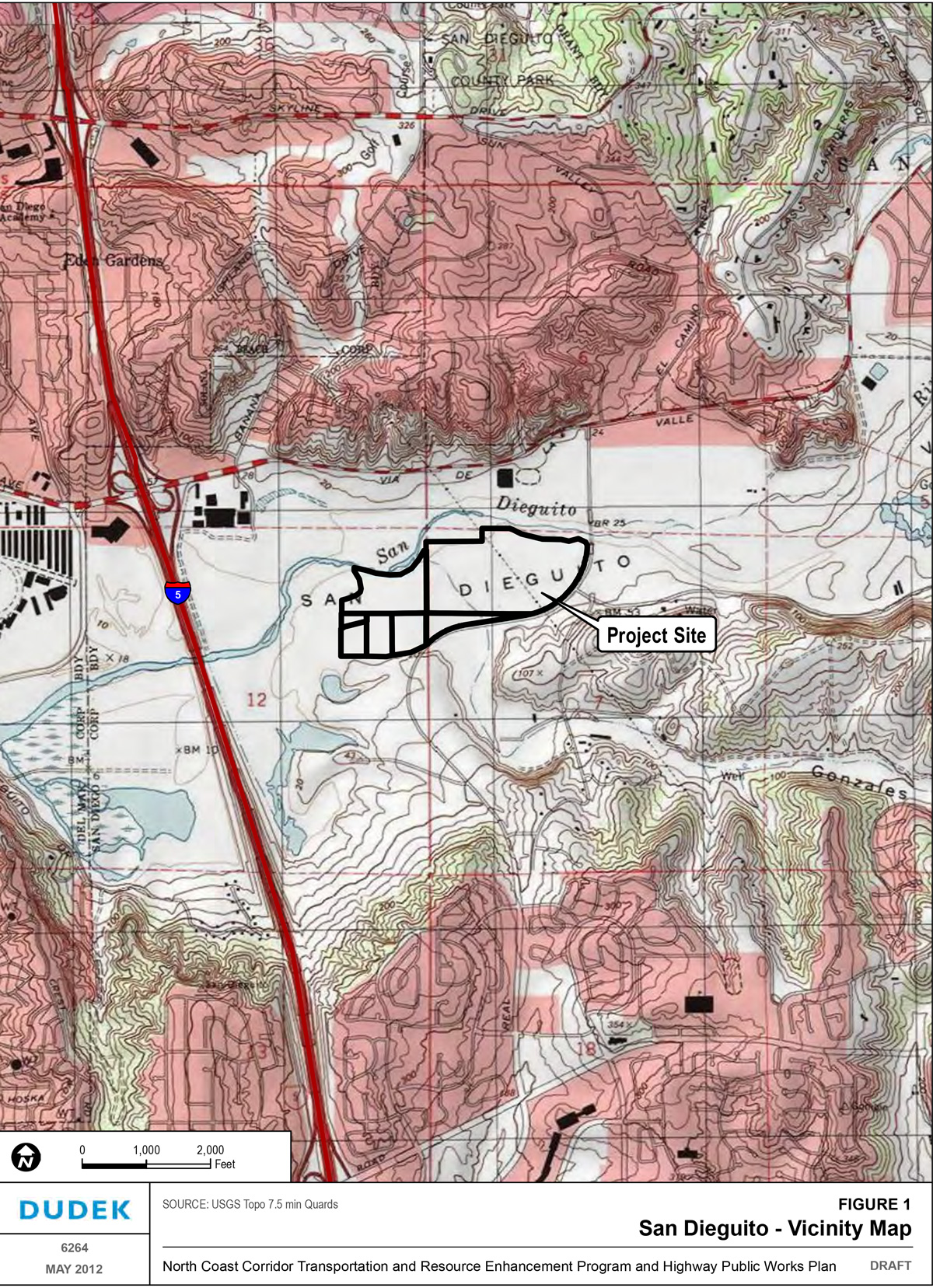
The mitigation site is located east of Interstate 5 (I-5), south of Via De La Valle and the San Dieguito River, and west of El Camino Real. The parcel is situated in the eastern portion of San Dieguito Lagoon (see Figure 1).
Latitude/Longitude
32.9722/-117.2357
APNs
299-040-300 (1.6 acres) and portions of the following parcels:
- 304-020-1300 (6.2 acres)
- 304-020-1600 (62.7 acres)
- 299-040-4100 (18.0 acres)
- 299-040-4700 (4.6 acres)
- 299-040-3700 (6.2 acres)
- 299-040-3600 (7.2 acres)
Ownership
Owners in the approximate 107-acre mitigation area include the San Dieguito River Park Joint Powers Authority (JPA), Southern California Edison (SCE), and the City of San Diego. San Diego Association of Governments (SANDAG) agreed with the JPA to secure the rights to restore 107 acres of land east of I-5 and to the south of the SCE coastal wetlands restoration project. In addition, the California Department of Transportation (Caltrans) has the rights over the restoration of 6 acres of the City of San Diego property at Caltrans discretion through a separate cooperative agreement.
Correspondence with Resource Agencies
A group of stakeholders, including the RWQCB, ACOE, CCC, CDFG, NMFS, and USFWS, was identified and brought together to discuss the feasibility of the W‐19 property to support the establishment and restoration of tidal and freshwater wetlands. Three stakeholder meetings were held in March and October 2011 and in April 2012.
In February 2012, the agencies met to discuss additional design alternatives, which are currently being evaluated by SANDAG and Caltrans. The stakeholder meetings resulted in no major disagreement regarding the feasibility of the site to be used as mitigation; coordination with the stakeholders will be ongoing as hydrologic and sediment transport modeling and design alternatives become devised.
Mitigation Goal
The SANDAG and Caltrans propose to mitigate impacts to sensitive wetlands habitats associated with the projects covered under the North Coast Corridor Public Works Plan/Transportation and Resource Enhancement Program (PWP/TREP) by creating and managing high-quality tidal wetland and upland habitat on the referenced parcels located on the eastern side of San Dieguito Lagoon. In addition, the City of San Diego will be mitigating impacts from the El Camino Real Bridge Replacement Project on a portion of the site in exchange for use of 14 acres of their property for salt marsh establishment. The goal of the mitigation project is to create new tidal wetlands and expand the tidal wetlands complex associated with the SCE San Dieguito Lagoon mitigation project, to create adjacent uplands habitat, and to ensure long-term management of the parcels in perpetuity.
This site assessment is largely based on information contained in the San Dieguito Lagoon W19 Restoration Project Feasibility Study (Dokken Engineering, December 2011). Excerpts from the San Dieguito Lagoon W19 Restoration Project Feasibility Study (Feasibility Study) is incorporated throughout this site assessment as noted in the following sections.
The Feasibility Study identifies the primary purpose of the mitigation site as follows:
The primary purpose of the proposed project is to restore the habitats that historically occurred within this coastal area, taking into consideration the constraints now imposed by existing adjacent land uses. In light of permanent losses of adjacent wetlands and aquatic areas in addition to permanent hydrologic modifications, and urbanization surrounding San Dieguito over the last century, complete restoration of wetland and aquatic functions to historical levels is not possible. However, there is an opportunity for the establishment and/or substantial restoration of large portions of the area that historically supported coastal wetlands. In addition, recent public acquisitions of the western river valley's floodplain areas and surrounding uplands provide many opportunities for restoration of native grasslands, coastal sage scrub, and other upland habitats, as well as brackish habitats that support lightfooted clapper rail. Finally, the project offers opportunities for public access and interpretation/education including trail links to the Coast to Crest Trail along the southern edge of the project area.
The proposed mitigation project will complement the SCE San Dieguito Wetland Restoration Project and contribute to achieving the overall vision of the restored San Dieguito Lagoon system. The Feasibility Study identifies the San Dieguito Lagoon W19 Restoration Project's the ultimate goal as achieving the establishment of at least 50 acres of tidal wetland area to the west of the utility corridor and the east of I-5 and at least 14 acres of brackish wetland area to the east of the utility corridor and the west of El Camino Real Road. For purposes of the North Coast Corridor PWP/TREP, the proposed mitigation is intended to create 48.4 acres of wetland habitat and to establish 19.8 acres of high-quality upland habitat within the mitigation area, which will provide new and improved ecosystem continuity through connectivity between coastal wetlands and native uplands. Any sections of the proposed link to the Coast to Crest Trail along the southern edge of the project, the area is not included in the restoration totals of the site.
Table 1: Habitat Mitigation Goals
| Habitat Types | Mitigation Type | Mitigation Acreage |
|---|---|---|
| Coastal Wetlands | Establishment | 48.4 ac. |
| Uplands | Rehabilitation | 19.8 ac. |
Existing Conditions
Ecological Context
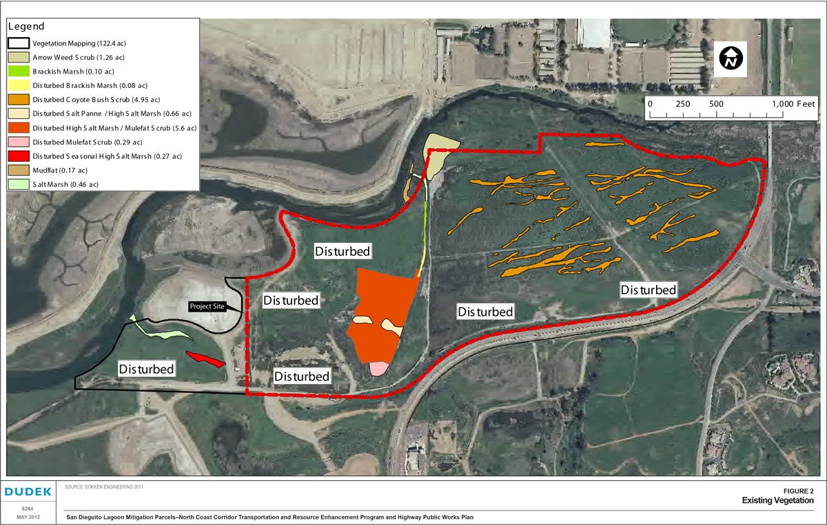
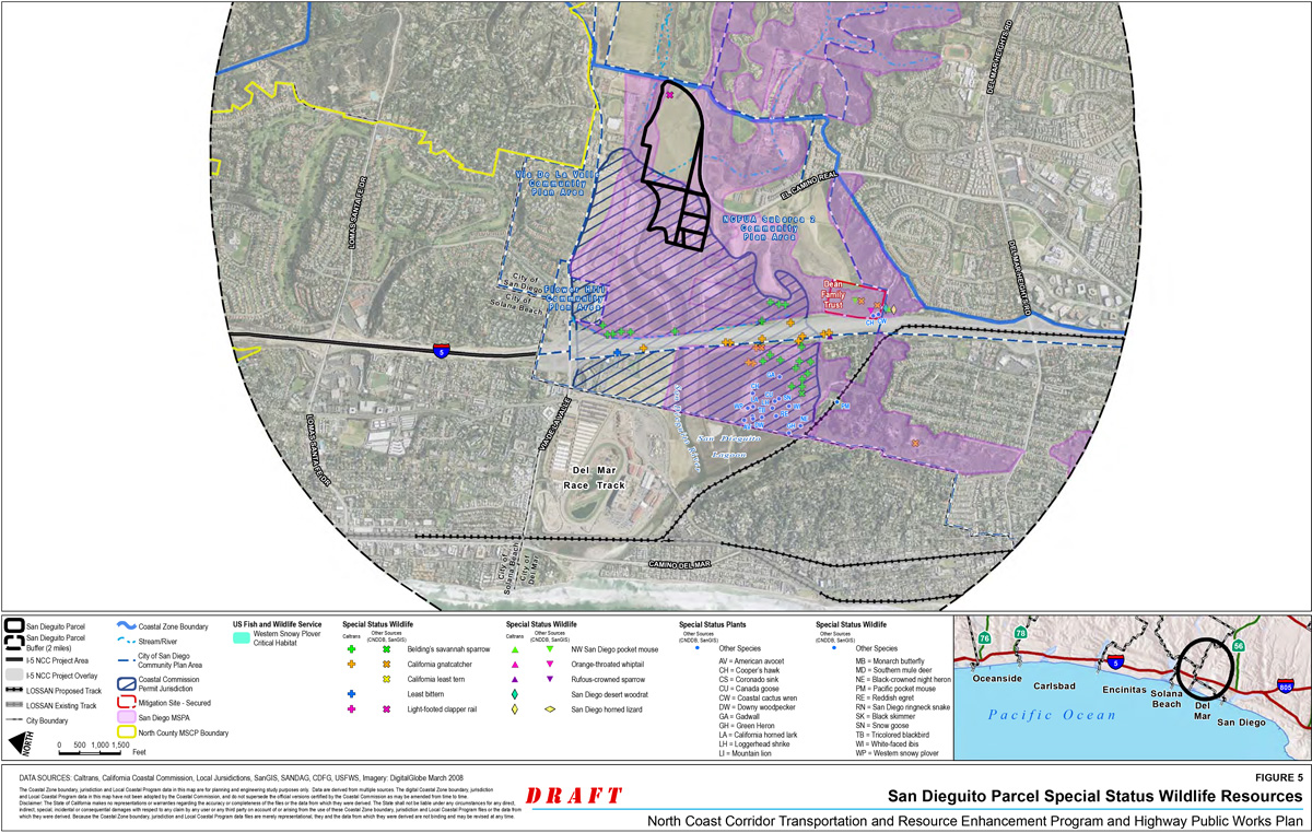
The San Dieguito Lagoon W19 mitigation site is located in the San Dieguito River Valley, within the northern portion of the City of San Diego. The mitigation site is located within the Focused Planning Area of the JPA's San Dieguito River Park and is located within the City of San Diego Multiple Habitat Planning Area (MHPA). The majority of the mitigation site was previously disturbed by agricultural activities (see Figure 2). Nonetheless, the California Natural Diversity Database (CNDDB) indicates numerous sensitive plant and wildlife species are present in the vicinity of the San Dieguito Lagoon W19 mitigation site (see Figures 3 to 5).
The Feasibility Study notes that although San Dieguito Lagoon has suffered damage as a result of human alteration, the lagoon's existing non-tidal wetlands and flats provide regionally important feeding and resting areas for migratory birds along the Pacific Flyway. The lagoon's tidal open water, mudflat, and salt marsh habitats also support a variety of birds, fishes, and invertebrates. Restoration of the lagoon would substantially improve the biological value of this resource. The Feasibility Study further notes that within the Del Mar USGS 7.5' Quadrangle surrounding the project area, 28 species are either federally or state-listed as threatened or endangered and many other species that are listed as species of concern or California Native Plant Society sensitive species. The federally and state threatened or endangered species include 17 plant species and other wildlife including western snowy plover (Charadrius alexandrines nivosus), California black rail (Laterallus jamaicensis coturniculus), Belding's savanna sparrow (Passerculus sandwichensis beldingi), coastal California gnatcatcher (Polioptila californica californica), light-footed clapper rail (Rallus longirostris levipes), California least tern (Sternula antillarum browni), least Bell's vireo (Vireo bellii pusillus), and Pacific pocket mouse (Perognathus longimembris pacificus) (CNDDB Rare find 4 Query, 2011). There is no critical habitat in the project area.
Drainage and Hydrology
Jurisdictional waters associated with the San Dieguito Lagoon system occur in the project area. Groundwater occurs at depths between 7.0 and 9.5 feet below the existing grade. Various drainages exist throughout the site including man-made drainages associated with past agricultural land uses.
Soils
The Feasibility Study indicates that soils at the mitigation site consist generally of alluvial deposits consisting of very soft to soft sandy silt, loose to medium dense silty sand, and occasional gravel and pockets of clayey sand. A limited amount of beach quality sand has also been observed within the mitigation area.
Vegetation
The majority of the mitigation site has been previously disturbed by agricultural activities. The Feasibility Study identifies vegetation communities occurring on the site, as illustrated in Figure 2, and describes the communities as follows.
- Disturbed habitat: The majority of the site is considered disturbed and occurs in areas impacted by SCE's restoration or in areas of former agricultural activities. A mixture of non-native invasive species, as well as native species, dominate these areas. Non-native dominants include prickly Russian-thistle (Salsola tragus), five-hook bassia (Bassia hyssopifolia), tree tobacco (Nicotiana glauca) and non-native grasses, e.g., bromes (Bromus spp.). Native species include coyote brush (Baccharis pilularis), broom Baccharis (Baccharis sarothroides), and scattered mule-fat (Baccharis salicifolia).
- Disturbed coyote brush scrub: This habitat occurs in drainage ditches on the former tomato fields that comprise the former Boudreau property. The dominant species is coyote brush with a broom Baccharis, prickly Russian thistle and five-hook bassia.
- Disturbed high salt marsh/mule fat scrub: This habitat has developed in low lying areas that were disturbed by the SCE project. These areas are low enough to pond water during winter. They support a mixture of native wetland species as well as invasive non-native species. Dominant native species include Pacific pickleweed (Sarcocornia Pacifica), bush seepweed (Suaeda nigra), alkali heath (Frankenia salina) and mule-fat. Non-natives include five-hook bassia and prickly Russian thistle.
- Arrow weed scrub: Arrow weed scrub consists of monotypic arrow weed (Pluchea sericea).
- Brackish marsh: Brackish marsh occurs in the north/south trending man-made channel associated with former agricultural activities. It is typified by elements of both salt marsh and freshwater marsh. Dominant species include Pacific pickleweed, California bulrush (Schoenoplectus californicus) and Olney's bulrush (Schoenoplectus americanus).
- Disturbed brackish marsh: Disturbed brackish marsh is similar to undisturbed brackish marsh except that it supports more weedy species. Dominant weedy species observed included curly dock (Rumex Crispus) and annual beard grass (Polypogon monspeliensis).
- Saltmarsh: Undisturbed salt marsh occurs in two areas within the project footprint; both in association with the San Dieguito River. Saltmarsh habitat on-site is dominated by Pacific pickleweed.
- Disturbed salt panne: Disturbed salt panne is primarily unvegetated but shows evidence of vehicles having recently accessed the site for the SCE project. Those vehicles have left tracks and ruts that impound water resulting in invasion by non-native grasses, such as bromes.
- Disturbed mule-fat scrub: Undisturbed mule-fat scrub is typically composed of scattered Mulefat with little understory. Disturbed mule-fat scrub differs from undisturbed mule-fat scrub by supporting a high percentage of invasive weedy species, including, five-hook bassia, tree tobacco, and prickly Russian thistle.
- Disturbed seasonal high salt marsh: Seasonal high salt marsh differs from the salt marsh by its hydraulic regime. Saltmarsh as defined here is connected hydraulically to the river and is inundated by tides, at least intermittently if not daily. The seasonal high salt marsh is isolated from tidal flows and represents as relic conditions from before this area of the lagoon was disturbed. Seasonal high salt marsh relies on rainfall for its persistence. The disturbed seasonal high salt marsh supports a high percentage of non-native invasive species including non-native grasses (e.g., bromes) and crystalline ice plant (Mesembryanthemum crystallinum).
Wildlife
The Feasibility Study identifies wildlife species occurring on the site including song sparrow (Melospiza melodia), common yellowthroat (Geothlypis trichas), American crow (Corvus brachyrhynchus), Anna's hummingbird (Calypte anna), goldfinch (Carduelis spp.), kingbird (Tyrannus sp.), and black phoebe (Sayornis nigricans).
Prior and Current Land Use
The majority of the mitigation site has been previously disturbed by agricultural activities. The site now primarily consists of open space and is zoned as open space within the City of San Diego's General Plan. The SCE San Dieguito Wetland Restoration Project, involving a comprehensive restoration project for approximately 150 acres of land in the western end of the San Dieguito River Valley is located just north and west of the proposed mitigation site. Land uses surrounding the site largely include Open Space Reserves and Preserves followed by water. Open Space Reserves and Preserves consist of areas to be retained in their natural state and protected from future encroachment, disturbance, or degradation (City of San Diego, 2007). Water areas consist of the San Dieguito Lagoon, bays and the San Dieguito River.
Constraints/Existing Utilities/Infrastructure/Easements
Preparation of the Feasibility Study included a review of right of way maps, as-built records, and design drawings from recently completed construction projects to determine the existence of utilities within the project vicinity (see Figure 6). A preliminary investigation indicated that the following utility companies have facilities within the project vicinity:
- AT&T
- Cox Communications
- Kinder Morgan
- NEXTG Networks
- SDG&E Electric
- SDG&E Gas
- City of Del Mar
The Feasibility Study notes that a 150-foot wide San Diego Gas and Electric (SDG&E) utility-corridor separates the proposed tidal wetland area from the proposed brackish wetland area. Within the project area, there is also an existing SDG&E electrical overhead line that runs north-south over the project area. A 10-inch abandoned steel pipe located within a 10-foot City of Del Mar easement was encountered and removed during the construction of the SCE Restoration Project. Approximately 2,600 feet of the 10-inch abandoned steel pipe is located within the mitigation site and will require removal for the San Dieguito Lagoon W19 Restoration Project. An extensive investigation into the utilities on the site will occur through the NOID process.
Any sections of the proposed link to the Coast to Crest Trail along the southern edge of the project area are not included in the restoration totals of the site. The proposed trail will be clearly defined and mapped, and the trail acreages not counted toward mitigation. Additional limitations involving the trail use, including hours of use, fencing, and signage, will be detailed in the Conceptual Mitigation Plan for the San Dieguito Lagoon W19 Restoration Site, through the NOID process and/or Coastal Development Permit.
Site access is via existing dirt roads that connect to El Camino Real on the south.
Mitigation Program
The San Dieguito Lagoon W19 mitigation site presents an opportunity to create tidal and brackish wetland and native upland habitats which will complement the SCE San Dieguito Wetland Restoration Project and contribute to achieving the overall vision of the restored San Dieguito Lagoon system. Depending on the restoration option selected and implemented for the site, restoration activities would involve modification to the site's existing hydrology, topography and vegetation communities to varying degrees; however, all options involve establishing a tidal wetland area west of the SDG&E utility corridor and a brackish wetland area east of the SDG&E utility corridor. In addition, creating native upland vegetation communities would support and maximize sensitive biological resources onsite, and create a seamless connection to restored wetland areas and adjacent open space lands.
Schedule
The Feasibility Study provides a concept for the mitigation design and a schedule for further development of the design, permitting and implementation (Table 2). Design and planning are ongoing with the development of more detailed alternatives analysis and an Environmental Assessment/Environmental Impact Report (EA/EIR) will further develop these concepts. The ACOE is the federal lead agency and JPA is the CEQA lead agency. All resource agencies have been involved in these discussions and will continue to be involved as alternatives are developed. Detailed design will be provided through the Notice of Intent to Develop (NOID) approval process during the first phase of implementation of the North Coast Corridor PWP/TREP. As discussed in Section 6.5.3 of the PWP/TREP, the results of the consultations with persons and agencies interested in, with jurisdiction over, and/or affected by the proposed development, including consultations with federal and state resource agencies (e.g., Army Corps, USFWS, CDFG, RWQCB, etc.), as well as all supporting documentation are required to be submitted along with the NOID project report. Accordingly, all design and related project reporting would be submitted to the permitting agencies for consultation as part of the NOID review and approval process.
Table 2: Mitigation Project Schedule
| Project Phase | Anticipated Start-Completion Date |
|---|---|
| Preliminary Design Engineering | 12/11-12/13 |
| CEQA/NEPA & PWP/TREP Preparation/Approval | 12/11-12/13 |
| Final Design/Project Report & Permitting (NOID/CDP/Federal Consistency & Agency Permits) | 12/13-12/14 |
| Implementation/Construction | 01/15-01/17 |
Mitigation Goal and Purpose
The goal of the mitigation project for the PWP/TREP is to create approximately 48.4 net acres of the tidal wetland area, with the rehabilitation of about 19.8 net acres of native upland habitat also occurring. The Feasibility Study describes the various habitat establishment benefits as follows:
- The created wetland habitats, in a particular salt marsh, are highly productive and efficient in transferring the energy produced by primary producers to higher trophic levels. Coastal wetlands, in particular salt marshes, are among the most productive systems in the world. The reason for this high productivity is that there are two major groups of primary producers (i.e., organisms that produce energy from sunlight) at the base of the flood chain – algae (including phytoplankton and macro-algae) and vascular plants. The food chain in salt marshes is shortened which makes primary productivity available directly to other trophic levels. For example, the California horned snail (Cerethidia californica) feeds, directly on macro-algae and, in turn, are preyed upon by higher-order consumers, such as the endangered light-footed clapper rail (Rallus longirostris levipes). In this example, the food chain is a three-step process and is very efficient at transferring energy from one trophic level to the next. (Nordby Biological Consultants et al, 2008).
- The interface between the tidal channel and salt marsh interface increases energy transfer by making algae and detritus available to invertebrates and small fishes. Tidal channels with an edge to length ratio of 50% or greater have been positively correlated with fish standing crops (Adamus et al 1980). The irregular plant/water interface also provides structure and protection for juvenile fishes, thereby serving a nursery ground for many fish species. The habitats that comprise a coastal wetland provide habitat and refuge for a number of taxa. These habitats intergrade and, as a result, their habitat functions overlap to some degree. (Nordby Biological Consultants et al, 2008).
The project would also create subtidal, mudflat, and transitional habitats. The values of these habitats include:
- Subtidal: Habitat for fishes and invertebrates. Important links between fish and piscivorous birds (diving and wading) and between higher trophic order fishes (predators such as halibut) and lower trophic order fishes, such as arrow goby.
- Mudflat: Mudflats are the feeding grounds for shorebirds. The invertebrate infauna, primarily polychaete worms, and mollusks are available with each receding tide. Fish also feed on mudflats while they are submerged. In terms of trophic relevance, the detritus and algae from the highly productive marsh provide energy to invertebrates, which in turn, transfer energy to birds and higher trophic order fish.
- Transition to upland: Transitional habitat is the least known habitat associated with wetlands in southern California, as most of this habitat has been lost to development. Some of the values ascribed to transition include:
- Provide an area of potential habitat transgression given predicted sea-level rise due to global climate change;
- Provide important upland refugee for shorebirds and other species during extreme high tides and/or storm events;
- Provide an important interface between wetland and upland for foraging bird species and other species, i.e. energy transfer;
- Provides a unique habitat where wetland and upland plant species co-occur; and
- Provide important habitat for pollinators, such as ground-nesting bees.
Hydrology
Tidal salt marsh hydrology will be established through topographic modification of the site that will create tidal connections to the portion of the San Dieguito River channel at the west end of the site and south of the SCE and 22nd District Agricultural Association's least tern nesting island. The goal is to design the site to have a similar tidal range as the SCE salt marsh wetland east of I-5 and north of San Dieguito River. In addition, the goal is to have no negative effect on the SCE mitigation site or downstream sediment transport. Fluvial hydraulics are also being modeled to ensure that there are no downstream floodplain impacts to structures or sediment transport.
Topographic Modification
The project will grade up to approximately one million cubic yards of soil from the abandoned agricultural fields. It is necessary to grade channels to allow water to flow into the created salt marsh habitat and allow for functioning low salt marsh and mudflat with mid to high marsh habitat. Depending on the restoration option selected, berms may be constructed to separate the San Diego River hydrology from the tidal hydrology, similar to the berm implemented by the SCE project.
Soils
Based on soil textural analysis and the lack of sand suitable for beach replenishment, the site appears to have suitable soils that will support salt marsh habitat. In addition, the adjacent SCE wetlands mitigation project was built on similar soil and has demonstrated soil suitability for the intended mitigation project.
Target Plant Communities
The target plant communities include lower, middle and upper salt marsh habitat and transitional and upland habitat. The design and plant palette will be determined during the development of the design for the environmental document.
Site Protection
The mitigation site is located within the San Dieguito River Valley. The JPA is the agency responsible for creating a natural open space park in the San Dieguito River Valley and is empowered to acquire, plan, design, improve, operate, and maintain the San Dieguito River Park. The mitigation parcels will add additional habitat to the restored San Dieguito Lagoon system and improved ecosystem continuity through connectivity between additional coastal wetlands and native uplands habitat to be maintained, managed and protected in perpetuity by the JPA.
Long Term Management
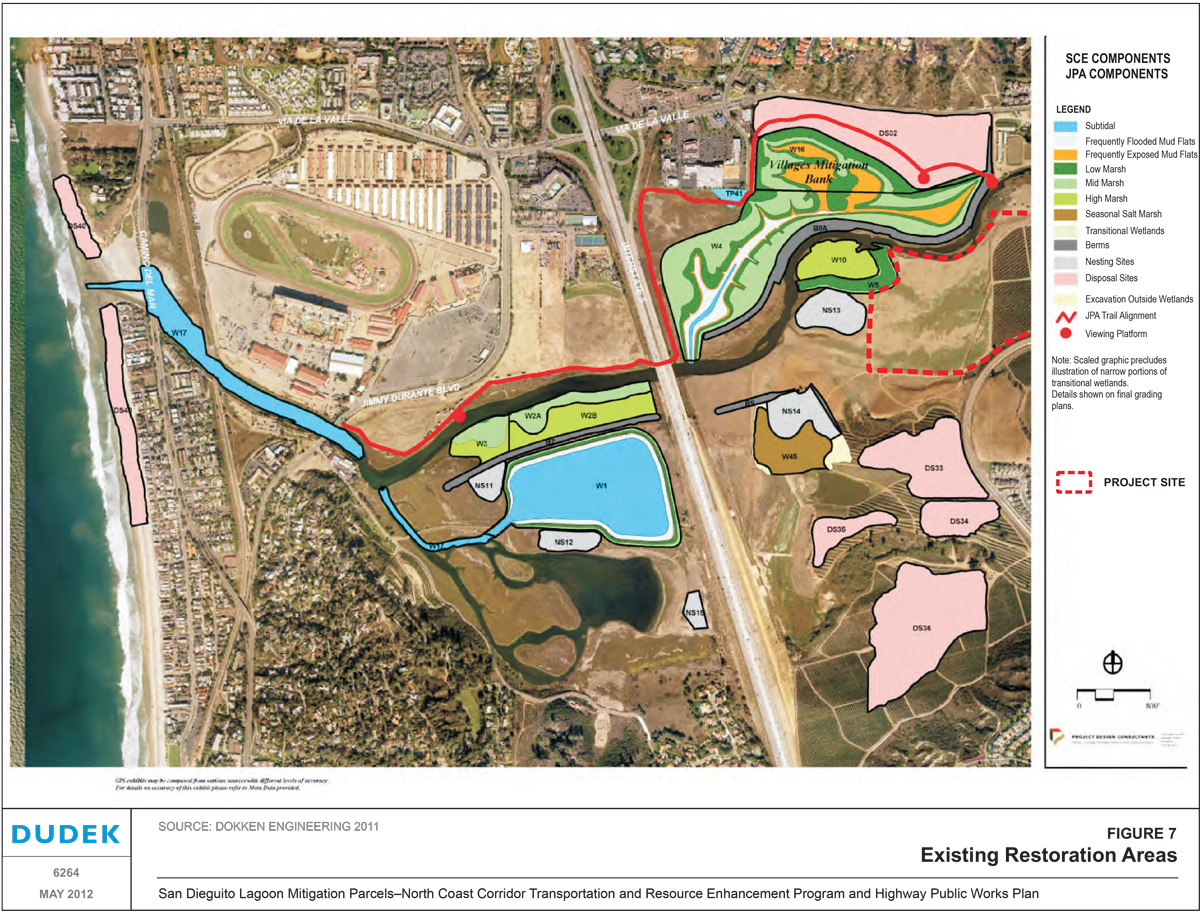
A Habitat Management Plan (HMP) will be prepared to define the long term management responsibilities to maintain the biological resources that are established through the mitigation project. The JPA will assume long term management responsibilities in association with other restoration properties within San Dieguito Lagoon (see Figure 7). Funds for long term management will be provided by SANDAG/Caltrans and placed into a non-wasting endowment. Endowment funds will be established using a Property Assessment Report that is based on the approved HMP.
Additional Studies
The preliminary engineering and alternatives development is ongoing and will be documented in the environmental documents.
Required Permits
A Coastal Commission approved NOID and/or coastal development permit with accompanying the project report will be required for project implementation. In addition, there are existing waters of the U.S. and State present within the project area. All potential options would require dredging and/or filling to convert the jurisdictional areas into marsh and upland habitat. The extent to which the various options will dredge and/or fill depends on several factors including the presence and size of the berms as well as the amount of land converted. Additional waters of the U.S. and State will be created through the project. As such, it is anticipated that the following additional agency permits will be required for the implementation of the mitigation project:
- Clean Water Act 404 from ACOE;
- Clean Water Act 401 from RWQCB;
- Clean Water Act 402 from the State Water Resources Control Board (SWRCB);
- 1602 Streambed Alteration Agreement with CDFG; and
- Endangered Species Act Section 7 Consultation with USFWS.
References
- Dokken Engineering, 2011. San Dieguito Lagoon W19 Restoration Project Feasibility Study. December 2011.
North Coast Corridor Mitigation Site Assessment for the San Dieguito Lagoon W19 Restoration Site


Draft
Hallmark Parcels
- Site Location: The Hallmark Properties are located along the margins of the northeastern portion of Agua Hedionda Lagoon. The properties consist of three parcels of land; a western parcel and two adjoining eastern parcels. The western parcel (Hallmark West) is approximately 11.1 acres in size and is located between Park Drive and Agua Hedionda Lagoon. The other two parcels (Hallmark East) are next to one another between the lagoon and the neighborhoods along Via Hinton and Via Marta (Figure 1); these parcels comprise approximately 8.2 acres.
- Latitude/Longitude: West Parcel 33.1428/-117.3174, East Parcels 33.1479/-117.3063
- APNs: 207-101-34-00, 207-101-33-00, and 208-020-43-00
- Ownership: Caltrans currently owns these parcels
- Correspondence with Resource Agencies: June 2008, Resource agencies receive a request from Caltrans and SANDAG to approve the site for acquisition; Letters acknowledging consideration of a site for mitigation received from CCC March 2009, CDFG July 2008, USFWS August 2008, and NMFS July 2008.
Mitigation Goal
The San Diego Association of Governments (SANDAG) and California Department of Transportation (Caltrans) proposes to mitigate impacts to Army Corps jurisdictional and State wetlands, as well as sensitive upland habitats associated with the North Coast Corridor Public Works Plan/Transportation and Resource Enhancement Program (PWP/TREP) by creating salt marsh habitat and restoring and preserving coastal sage scrub habitat on the Hallmark Parcels along the northern shore of Agua Hedionda Lagoon. The goal of the mitigation is to permanently retire the development potential of the sites, preserve existing wetland and upland habitat through site protection (easements and fence), enhance existing upland habitat through exotics removal, and to create tidal salt marsh habitat. The proposed mitigation treatments and native vegetation community establishment as indicated in Table 1 will provide the following benefits for:
- California gnatcatcher; by increasing resources within and adjacent to existing occupied gnatcatcher territories;
- Atriplex Pacifica; by preserving coastal sage scrub (CSS) habitat where it presently occurs and limiting unauthorized site access and the associated disturbance regime;
- Shorebird populations that utilize the Pacific flyway and Agua Hedionda Lagoon salt marsh habitat areas in particular by expanding tidal salt marsh habitat.
- Upland refugia for wildlife in the event of sea-level rise.
- Wetlands migration opportunities for salt marsh habitat in the event of sea-level rise.
West Parcel
This parcel is immediately adjacent to the ecological reserve owned by the California Department of Fish and Game (CDFG). There is the potential to create additional salt marsh habitat on the disturbed fingers of fill and natural headlands that extend into the tidal lagoon area. In addition, fencing and access control have discouraged bicycles and off-road vehicles that have made bike jumps and have driven into the marsh areas. With exotic removal and some planting, the upland areas could also be restored to a more natural condition. Restoration of tidal salt marsh will expand existing tidal wetlands providing important biological resources for shorebirds and aquatic species that are dependent upon the lagoon for spawning and nursery habitat. Upland areas will provide important opportunities for the slow upward migration of tidal saltmarsh vegetation communities as sea-level rise gradually occurs.
East Parcel
This parcel is also immediately adjacent to the Agua Hedionda Lagoon Ecological Reserve owned by the CDFG. The eastern end of this parcel is already deed-restricted and it is unlikely any work would take place at this end due to access restrictions; however, some exotic control may be completed along the riparian forest at this end of the parcel. Treatment of the slopes below the homes will be consistent with fire protection standards for plant density, vegetation height, and reduced cover using appropriate fire-resistant plantings. Deed restricted and fuel/fire zone areas would not be included in the restoration totals of the site. The remainder of the sloped parcel will be restored to CSS and the wetlands enhanced through the removal of exotics and planting with native species.
Table 1: Habitat Mitigation Goals
| Habitat Types | Mitigation Parcel | Mitigation Type | Mitigation Acreage |
|---|---|---|---|
| Coastal Sage Scrub | East/ West | Preservation/Enhancement | 1.8 |
| Coastal Sage Scrub | East/ West | Enhancement | 6.6 |
| Coastal Sage Scrub | East/West | Establishment | 3.5 |
| Riparian Wetland | East | Preservation/Enhancement | 0.32 |
| Freshwater Marsh | East/ West | Restoration/Enhancement | 0.52 |
| Brackish Marsh | East | Enhancement | 0.45 |
| Riparian | East | Establishment | 0.17 |
| Tidal Salt Marsh | West | Establishment | 4.2 |
| Tidal Salt March | West | Preservation | 0.12 |
Existing Conditions
Hallmark West Parcel
Ecological Context
The Hallmark West parcel is situated adjacent to Agua Hedionda Lagoon. The site supports a combination of salt marsh vegetation, coastal sage scrub vegetation, and disturbed areas (see Figures 2 and 4). Mitigation on this site will enhance biological resources within the lagoon ecosystem and provide greater synergistic ecological benefits in association with the larger ecological system such as water quality, wildlife, and habitat continuity on the north lagoon shoreline. The project will establish new tidal salt marsh habitat that provides biological resources and ecological functions used by salt marsh species and shorebirds that utilize the Pacific flyway. Upland mitigation will directly benefit California gnatcatcher and Atriplex Pacifica through habitat enhancements and preservation as provided by site restoration and enhancement, access restrictions, and long-term management.
Drainage and Hydrology
Overland drainage (sheet flow) generally occurs from the upland area into the adjacent salt marsh vegetation that is associated with Agua Hedionda lagoon. The overland flow has been modified into more concentrated flow patterns due to a lack of vegetation from a derelict revegetation effort on the upland slopes and at an old road cut where soil excavation previously occurred. The concentrated flow has resulted in erosive conditions that are transporting sand to the lagoon.
The lagoon is subject to tidal hydrology (ebb and flow) that affects lagoon shoreline areas below the high tide elevation. These areas typically support salt marsh vegetation.
Storm drainage from the adjacent neighborhood and Park Avenue drains through a culvert into a disturbed wetland at the eastern end of the parcel.
Soils
Upland and soils within the proposed salt marsh creation area are Huerhuero loam associated with marine terraces. Parent material is calcareous alluvium derived from sedimentary rock. The typical soil profile is loam within 0-10 inches below land surface (bls), clay loam/clay from 10-50 inches bls, and stratified sand to sandy loam from 50-60 inches bls (NRCS, soil survey maps). Due to past grading activities, most soils within disturbed habitat areas and the proposed salt marsh mitigation area are sand to sandy loam. The soil within the non-graded and intact habitat areas retain the topsoil characteristics of Huerhuero loam.
Vegetation
The Hallmark West Parcel is composed of coastal sage scrub, salt marsh, salt marsh transition, freshwater marsh, southern willow scrub, disturbed habitat, and bare ground (see Figures 2, 4 and 5). Table 2 presents a summary of existing vegetation communities and land covers present on Hallmark West.
The coastal sage scrub (CSS) habitat is dominated by coastal sagebrush (Artemisia californica), coyote bush (Baccharis pilularis) and goldenbush (Isocoma menziesii). Other common species found in the coastal sage scrub on-site include prickly pear (Opuntia littoralis), lemonadeberry (Rhus integrifolia), and laurel sumac (Malosma laurina). The disturbed CSS contains up to 35 percent nonnative exotic species including black mustard (Brassica nigra), pampas grass (Cortaderia sp.), ice plant (Carpobrotus edulis), and nonnative grasses. Sparse CSS on slopes facing southwest have extensive rilling of the sandstone and now support less than 40 percent CSS species, with the remainder as bare ground.
Table 2: Existing Vegetation Communities for Hallmark West
| Community Name/Land Cover | Map Code1 | Acreage |
|---|---|---|
| Bare Ground | BG | 1.98 |
| Coastal Sage Scrub | CSS | 1.04 |
| Disturbed Coastal Sage Scrub | CSS-D | 4.28 |
| Sparse Coastal Sage Scrub | CSS-S | 0.90 |
| Disturbed Habitat | DH | 0.64 |
| Freshwater Marsh | FWM | 0.18 |
| Salt Bush Scrub | SBS | 0.31 |
| Salt Marsh | SM | 0.12 |
| Salt Marsh Transitional | SMT | 0.96 |
| Disturbed Salt Marsh Transitional | SMT-D | 0.64 |
CSS is located on a small knoll and slope on the north side of the parcel. Patches of CSS habitat are high quality, relatively intact habitat with minor trails and openings. These patches have high native cover, low weed cover, and high diversity. California gnatcatchers present on site are utilizing the higher quality habitat patches for nesting and forage. Disturbed CSS (dCSS) is present in areas where the soil was dug from the hillside and in fingers of habitat that extend out from the toe of the slope toward the lagoon. The sparse CSS areas have a low native cover and high representation of bare ground (exposed sandstone). Weed cover is low due to the lack of topsoil and highly erosive condition as demonstrated by sediment flowing from the excavated area. Habitat occurring on flat areas is degraded by past public uses that promoted non-native vegetation along numerous redundant trails.
The salt marsh (SM) habitat is present in small fingers that extend back toward the parcel boundaries from the lagoon. The salt marsh habitat is dominated by pickleweed (Salicornia virginica), and cordgrass (Spartina foliosa) with some alkali heath (Frankenia salina), saltwort (Batis maritima) and saltgrass (Distichlis spicata). Only a small amount of this habitat is within the parcel and extends out toward the lagoon.
Between the SM and CSS is the salt marsh transition (SMT) community that has components of both the salt marsh and CSS. This transition habitat is dominated by saltgrass, coyote bush, goldenbush, and alkali heath. Other species in this transition habitat include spiny rush (Juncus acutus), pickleweed, fennel (Foeniculum vulgare), and cholla (Cylindopuntia prolifera). Much of the SMT habitat is disturbed with black mustard, slender-leaf ice plant (Mesembryanthemum nodiflorum), and nonnative grasses.
There is small drainage running from Park Drive into the lagoon at the eastern end of the west parcel. This drainage is an incised channel that supports freshwater marsh (FWM). The FWM is dominated by cattails (Typha sp.), with saltgrass, myoporum (Myoporum laetum), western ragweed (Ambrosia psilostachya), tobacco tree (Nicotiana glauca), and marsh fleabane (Pluchea odorata). Immediately surrounding the freshwater marsh area is coastal brackish marsh dominated by spiny rush with some pickleweed, saltgrass, and alkali heath. In one corner of the marsh, there is a small patch of disturbed SWS dominated by sandbar willow (Salix exigua), with mulefat (Baccharis salicifolia), a few tamarisks (Tamarix spp.), and pampas grass.
The remainder of the West parcel is composed primarily of bare ground (BG) and disturbed habitat (DH). Bare ground areas are found on trails, and on fingers of fill that extend out into the area that was formerly wetland. These areas have less than 10 percent cover and most of what does grow on these compacted soils are weedy species. However, Atriplex Pacifica also occurs within and immediately adjacent to these disturbance areas The disturbed habitat is dominated by black mustard, ice plant, slender-leaf ice plant, and yellow sweet clover (Melilotus indica).
Wildlife
Protocol surveys of the parcel identified two pairs of federally threatened coastal California gnatcatchers (Polioptila californica californica) on-site (see Figures 2 and 6). One of the pairs had at least one fledgling in May 2008. Other bird species that commonly occur on-site include California towhee (Pipilo crissalis), Bewick's wren (Thryothorus bewickii), song sparrow (Melospiza melodia), Anna's hummingbird (Calypte anna), lesser goldfinch (Carduelis psaltria), common yellowthroat (Geothlypis trichas), bushtit (Psaltriparus minimus), and northern harrier (Circus cyaneus). Other wildlife species observed on-site include coyote (Canis latrans), western fence lizard (Sceloporus occidentalis), desert cottontail (Sylvilagus audubonii), and California ground squirrel (Spermophilus beecheyi). Several shorebirds were observed adjacent to the site including black-necked stilt (Himantopus mexicanus), American avocet, willet (Catoptrophorus semipalmatus), marbled godwit, and great egret (Casmerodius albus).
Two pairs of federally threatened coastal California Gnatcatchers were identified at the west parcel (see Figures 2, 4 and 6). Atriplex Pacifica was observed on site. A. Pacifica is a CNPS List 1B.2 species: a rare, threatened, or endangered in California and elsewhere that is fairly endangered in California.
Prior and Current Land Use
The site is highly disturbed from a time when the land was planned for development. Prior to 2009, there were illegal trails, dumping, bike jumps, fire pits and other trespassing on site. In 2009, 2,025 feet of fencing was replaced on-site with 735 feet of that fence replaced on CDFG land east of the site to limit access and illegal activities onsite. The proposed land use for the site will be for open space and habitat preservation and management.
Existing Utilities/Infrastructure/Easements
There are no known utilities, infrastructure, and easements on-site that would constrain the mitigation project (Figure 7).
Hallmark East Parcel
Ecological Context
The Hallmark East Parcel lies between some residential housing and riparian habitat associated with Agua Hedionda Creek that is owned and managed by the CDFG (see Figures 3 and 4). The east parcel is 0.8 miles upstream of the Agua Hedionda lagoon. The mitigation site presents an opportunity to establish and enhance brackish marsh into the low lying area of the mitigation site. Slope restoration and enhancement are proposed that would create a habitat buffer between existing residential land use and fuel modifications zones and the existing riparian habitat.
The existing riparian habitat sliver is the edge of a larger stand of riparian forest associated with Agua Hedionda Creek. The riparian vegetation extends downstream toward the lagoon until saltwater influences cause the vegetation to transition to the brackish marsh and tidal salt marsh, mudflats, and salt panne.
Drainage and Hydrology
Drainage on-site is heavily modified and dictated by adjacent residential development. Drainage from streets and residential lots occurs through sheet flow and concentrated flow from the road edge. A storm drain outfall is present at the bottom of the existing road slope. The drainage settles in a low area on site as evidenced by a patch of disturbed freshwater marsh vegetation. The eastern end of the parcel is deed-restricted habitats located along the slopes of drainages.
Soils
The central area of the mitigation site is flat to gently slope toward the riparian area. Manufactured slopes approximately 20 feet tall with a 2:1 gradient surround the low lying area and mitigation area to the east and west of this parcel.
The soil within the east parcel is mapped as Las Flores loamy fine sand in the NRCS soil survey. These soils are derived from the sandstone parent material. The water capacity is low. The typical soil profile includes loamy fine sand from 0-14c inches bls, sandy clay/sand from 14-38 inches bls, and loamy coarse sand from 38-48 inches bls.
Vegetation
Existing habitats on the Hallmark East parcel are CSS, Baccharis scrub, FWM, coastal brackish marsh, riparian forest, non-native woodland, ornamental, DH, and BG (see Figures 3-5). Table 3 presents a summary of the existing vegetation communities and land covers found on Hallmark East.
Table 3: Existing Vegetation Communities for Hallmark East
| Community Name/Land Cover | Map Code1 | Acreage |
|---|---|---|
| Bare Ground | BG | 0.44 |
| Disturbed Baccharis Scrub | BBS-D | 0.28 |
| Coastal Brackish Marsh | CBM | 0.32 |
| Disturbed Coastal Brackish Marsh | CBM-D | 0.13 |
| Coastal Sage Scrub | CSS | 0.78 |
| Disturbed Coastal Sage Scrub | CSS-D | 1.14 |
| Disturbed Habitat | DH | 0.96 |
| Freshwater Marsh | FWM | 0.34 |
| Non-Native Woodland | NNW | 0.17 |
| Ornamental | ORN | 3.16 |
| Riparian Forest | RF | 0.25 |
| Salt Marsh Transitional | SMT | 0.05 |
| Disturbed Southern Willow Scrub | SWS-D | 0.07 |
The CSS is similar in composition to the West parcel with coastal sagebrush and coyote bush as the dominant components. The slopes in the center of the parcel off Via Hinton are good quality habitat with trails through the habitat. Further to the west, the CSS is disturbed with at least 50 percent of the area either bare ground or annual exotic species including black mustard, pampas grass, myoporum, and sour grass (Oxalis sp.).
The disturbed Baccharis scrub (BBS-D) is dominated by coyote bush and mustard with pampas grass and fennel. It occurs at the eastern end of the parcel at the end of the drainage down the canyon.
Brackish marsh (BM) dominated by cattails is found in a drainage in the center of the parcel. This marsh appears to be fed by a combination of urban runoff from the surrounding neighborhood and groundwater from Agua Hedionda Creek. Immediately surrounding the freshwater marsh area is coastal brackish marsh dominated by spiny rush with some pickleweed, saltgrass, and alkali heath.
Riparian forest (RF) habitat occurs at the base of the slopes east of the sewer easement (Figure 3). This habitat consists of large mature willows (Salix spp.) with western sycamore (Platanus racemosa) and a few nonnative trees. The understory of this habitat is a mixture of spiny rush, cattails, small willows, and herbaceous plants. There is only a small sliver of riparian forest within the parcel.
Between the houses and the CSS, habitats are slopes dominated by ornamental vegetation (ORN) including ice plants (Malephora sp. and Lampranthus sp.) with mustard, African fountain grass (Pennisetum setaceum), fan palm (Washingtonia robusta), pampas grass, and wild oats (Avena sp.).
Nonnative woodland (NNW) habitat is found between the freshwater marsh and disturbed habitat off Via Hinton and on the slopes at the eastern end of the parcel. The nonnative woodland is a combination of eucalyptus trees (Eucalyptus sp.), Brazilian pepper (Schinus terebinthifolius), Peruvian pepper (Schinus molle), and palms (Washingtonia sp. and Phoenix spp.). There is one arroyo willow (Salix lasiolepis) in the middle of the nonnative woodland off Via Hinton.
DH and BG habitats are similar to those habitats in the Hallmark West parcel. The BG occurs along trails and on the sewer access road at the base of the slope and up to Via Hinton where parent sandstone is exposed. The DH is found between the NNW and ORN and consists primarily of black mustard.
Wildlife
Birds observed on site were the California towhee, spotted towhee (Pipilo erythrophthalmus), common yellowthroat, Nuttall's woodpecker (Picoides nuttallii), lesser goldfinch, Anna's hummingbird, and wrentit (Chamaea fasciata). In the adjacent riparian forest, a number of riparian bird species were detected including yellow-breasted chat (Icteria virens), black-headed grosbeak (Pheucticus melanocephalus), and brown-headed cowbird (Molothrus ater) (see Figures 4 and 6).
One pair of California gnatcatchers was identified on this parcel (see Figures 3, 4 and 6).
Prior and Current Land Use
There have been a motorcycle, bicycle, and pedestrian trespassing throughout the properties in the past. This has resulted in erosion, creation of bike jumps on-site and degradation of the habitats on site. Neighborhood pets may use the area for foraging. The slopes down from the residential lots are maintained as fire buffers for the development. Required fire buffers are 100-feet wide in San Diego County.
Existing Utilities/Infrastructure/Easements
There is a sewer easement on the southern edge of the site along the boundary between the CDFG land and the Caltrans parcel, and also through the middle of the site that connects to Via Hinton. These easements must be maintained for utility access. In addition to underground sewer utilities and facilities access, the easements are informally used by the public for hiking and dog walking. The slopes below the houses have ornamental landscapes and many have deed restrictions. These slopes appear to be managed fire buffer zones (see Figure 8).
Mitigation Program
A brief conceptual plan for wetland creation and upland restoration was drafted to get preliminary concurrence from the CDFG that wetland creation on their lands is acceptable to be able to restore areas of the Hallmark West Parcel. The conceptual plan is described below and shown in Figure 9. Detailed conceptual mitigation plans for the East and West parcels will be prepared following additional site investigations. The report will be submitted as part of the Notice of Impending Development (NOID) for review and approval. The detailed conceptual plan will include plant palettes for target vegetation communities and specify the material type (container plant, seed, etc.), container sizes and density of planting. Seed mixes will specify species and seed quality by the minimum percentage of pure live seed per pound. Site-specific function-based performance criteria will be presented based on local reference vegetation of the same vegetation community to be restored and functional data from proposed impact areas.
Hallmark West Parcel
Schedule
The design of the wetland mitigation plan will begin when approval is received from the resource agencies that mitigation is appropriate and will be counted toward mitigating the North Coast Corridor multi-modal transportation project impacts. Detailed design will be provided through the NOID approval process during the first phase of implementation of the North Coast Corridor PWP/TREP. As discussed in Section 6.5.3 of the PWP/TREP, the results of the consultations with persons and agencies interested in, with jurisdiction over, and/or affected by the proposed development, including consultations with federal and state resource agencies (e.g., Army Corps, USFWS, CDFG, RWQCB, etc.), as well as all supporting documentation are required to be submitted along with the NOID project report. Accordingly, all design and related project reporting would be submitted to the permitting agencies for consultation as part of the NOID review and approval process.
Mitigation Goal and Purpose
The total created salt marsh area would equal 4.2 acres, 1.3 acres on Caltrans property and 2.9 acres on CDFG property. The creation of salt marsh in the existing fill would enhance the flow and habitat quality of the adjacent salt marsh habitat on CDFG land. The additional sub-tidal channels and low marsh/mudflat would increase flushing and provide important foraging habitat for a number of bird species. The additional mid and high marsh will form contiguous salt marsh habitat with the adjacent habitats. Created tidal salt marsh will have similar species composition and structure as observed in representative salt marsh habitat found within Agua Hedionda lagoon near the mitigation site.
Upland mitigation will restore and enhance existing disturbed CSS habitat (4.28 acres) and sparse CSS (0.9 acres) onsite, and preserve extant occupied CSS habitat (1.04 acres). The enhancement will occur through site access restriction to reduce the disturbance regime associated with unauthorized site entry, seed applications, and weed control during a 5-year maintenance period corresponding with the saltmarsh establishment period, and long term management for the site protection and weed control.
Establishment of CSS on some bare ground and disturbed habitat areas (approximately 2.0 acres) would include exotic control, container planting and seeding and possibly temporary irrigation.
After approval of the proposed salt marsh and upland mitigation area and proposed work on CDFG property, Caltrans will begin developing a detailed mitigation plan for the sites. The resource agencies will be consulted during the design process to ensure that plans account for any concerns with grading, types of habitats created, and potential temporary impacts to adjacent habitats.
Hydrology
Tidal salt marsh hydrology will be established through topographic modification of the site that will create tidal connections to Agua Hedionda Lagoon and existing adjacent salt marsh habitat. The created salt marsh would have a series of channels to bring flow into the three areas with a combination of the low, middle, and high marsh habitats with some mudflats (Figure 9).
Upland hydrology will primarily be maintained as overland sheet flow, terminating at the lagoon/saltmarsh edge. However, some minimal topographic modifications will be implemented in upland areas where erosion has occurred to reduce concentrated runoff and erosive conditions.
Topographic Modification
SANDAG/Caltrans proposes to grade the disturbed peninsulas of fill that extend out in between the existing CDFG owned salt marsh habitat. In addition, SANDAG/Caltrans proposes to grade additional filled areas owned by the CDFG that are between Caltrans property and the lagoon proper. It is necessary to grade channels to allow water to flow into the created salt marsh habitat and allow for functioning low salt marsh and mudflat with mid to high marsh habitat. The berms that create barriers to water flow will be partially graded to allow water to flow into the creation areas.
Within the upland area, old road cuts and excavation areas will be smoothed to re-establish overland sheet flow. These grade modifications are intended to stabilize the soil surface to reduce erosion and allow the areas to be restored to native CSS vegetation.
Soils
Soil testing would be completed during the design process to determine what soils and groundwater are expected onsite to help in designing the salt marsh restoration. Any soil deficiencies or issues will be examined to ensure that plans take into account soils found onsite.
Soil testing will be conducted in the upland areas where topographic modification is proposed to determine the need for soil amendments that will promote soil and vegetation community restoration.
Target Plant Communities
Coastal sage scrub will be established in uplands areas outside the salt marsh habitat areas that are not deed restricted or are fuel modification zones. Target plant communities in the salt marsh mitigation site include upper and mid salt marsh vegetation communities. Sub-tidal channels and associated low marsh/mudflat will be incorporated into the final design to facilitate tidal flushing and hydrology that will support the target plant communities. Table 4 presents the expected dominant species that will be present within each of these plant communities. Additional herbaceous and annual species will be added to the plant palette in the NOID submittal to provide appropriate species diversity that is typical of comparable adjacent existing habitat.
Table 4: Target Dominant Species by Vegetation Community
| Vegetation Community | Botanical Name | Common Name |
|---|---|---|
| Coastal Sage Scrub | Artemisia californica | California Sagebrush |
| Baccharis pilularis | coyote bush | |
| Distichlis spicata | saltgrass | |
| Encelia californica | California encelia | |
| Eriogonum fasciculatum | flat-top buckwheat | |
| Isocoma menziesii var. vernonoides | coast goldenbush | |
| Opuntia littoralis | prickly-pear cactus | |
| Upper Marsh | Batis maritime | saltwort |
| Jaumea carnosa | fleshy jaumea | |
| Juncus acutus | spiny rush | |
| Limonium californicum var. mexicanum | San Diego rosemary | |
| Monanthochloe littoralis | salt-cedar | |
| Salicornia subterminalis | Parish’s glasswort | |
| Sueda taxifolia | woolly sea-blite | |
| Middle Marsh | Frankenia salina | alkali-heath |
| Salicornia virginica | pickleweed |
Coastal sage scrub will be established mainly through the removal of exotic species and the application of a non-irrigated seed mix. Container planting will be added in areas where construction activities disturb soils and where no existing native vegetation is present (i.e., disturbed habitat/ornamental). Saltmarsh vegetation communities will be established using small-size (i.e., flats, rose pots and liners) container plantings. No seed mix is proposed for salt marsh mitigation areas.
Supportive Measures
Limited temporary irrigation may be installed to facilitate vegetation establishment in transitional areas between the tidal limits of the salt marsh mitigation and upland areas. Upland areas lacking existing native cover and areas disturbed by the construction of the mitigation site (e.g. access routes, staging areas, etc.) will be temporarily irrigated to increase the certainty of mitigation performance and success. No irrigation is proposed in upland areas with existing disturbed or undisturbed CSS vegetation. Areas with tidal influence will not be irrigated. All temporary irrigation will cease after 1-3 years depending upon vegetation establishment as determined by the project biologist.
Performance Criteria
Performance criteria will be developed from reference sites within or adjacent to the mitigation parcel. Existing CSS vegetation on site will be sampled using vegetation transects to establish appropriate vegetation cover and species diversity criteria. Other performance criteria will include native seedling recruitment, non-native vegetation cover, soil stability (lack of erosion), and wildlife use of the area. Criteria will be established that provides a high level of confidence that, once performance criteria are achieved, the resultant vegetation communities will be resilient and persistent as a demonstration of self-sustainability under a long term management program.
Mitigation results for uplands on the west parcel are expected to increase native cover and species diversity to around 85% of adjacent undisturbed habitat while reducing non-native cover to 5% or less of total vegetation cover. The specifics of the performance criteria will be detailed in the Conceptual Mitigation Plan for the Hallmark Parcels, through the NOID process and/or Coastal Development Permit. Erosive slope areas will be stabilized through grading, long term Best Management Practices mainly in the form of bioengineered solutions, and vegetation establishment to re-establish overland sheet flow. Stabilization of disturbed slopes will improve water quality in the lagoon by reducing elevated sediment transport into upland terraces and tidal wetlands.
Saltmarsh performance criteria will be similarly based on a local reference site. Criteria appropriate to each salt marsh habitat type (e.g., middle/upper salt marsh, mudflat, etc.) will include appropriate tidal hydrology (prism), native vegetation cover and species diversity, native seedling recruitment, microtopographic variation, tidal channel stability, biochemical activity, wildlife use, and benthic macro-invertebrate diversity.
Comparative analysis of pre-and post-mitigation site conditions will demonstrate the anticipated improvements in biological resources and ecological function. A description of the pre- and post-mitigation condition is listed below to demonstrate the benefits anticipated from the proposed mitigation.
- Tidal hydrology is absent at the proposed salt marsh mitigation site. Site grading to elevations within the tidal prism will establish tidal hydrology that will support salt marsh habitat.
- No salt marsh vegetation is present within the mitigation areas. Therefore, a significant increase in vegetation resources can be expected in the post-project condition. Saltmarsh vegetation provides forage, cover, and nesting opportunities for numerous avian species, and biological resources (habitat) for aquatic species.
- Exotic, perennial non-native vegetation will represent less than 0% relative vegetation cover at the end of the mitigation maintenance and monitoring period. This low level of non-native vegetation will result in a high-quality, self-sustaining habitat that can transition into long term management.
- Implementation of the proposed mitigation treatment will substantially change soil texture characteristics that will directly benefit macro-invertebrate populations where none presently exists. Macro-invertebrates will provide expanded forage for shorebird and fish populations that utilize the lagoon.
Criteria metrics will be developed in accordance with functional analysis methodologies to establish interim and final functional criteria. Interim target functional criteria scores will be used to inform maintenance decisions and regimes during the five-year monitoring and maintenance period to achieve the final target functional criteria scores.
Hallmark East Parcel
Schedule
The design of the wetland mitigation will begin when approval is received from the resource agencies that mitigation is appropriate and will be counted toward mitigating the North Coast Corridor multi-modal transportation project impacts. Detailed design will be provided through the NOID approval process, during the first phase of implementation of the North Coast Corridor PWP/TREP. As discussed in Section 6.5.3 of the PWP/TREP, the results of the consultations with persons and agencies interested in, with jurisdiction over, and/or affected by the proposed development, including consultations with federal and state resource agencies (e.g., Army Corps, USFWS, CDFG, RWQCB, etc.), as well as all supporting documentation are required to be submitted along with the NOID project report. Accordingly, all design and related project reporting would be submitted to the permitting agencies for consultation as part of the NOID review and approval process.
Mitigation Goal and Purpose
SANDAG and Caltrans propose to mitigate impacts to Army Corps jurisdictional and State wetlands, as well as sensitive upland habitats associated with the North Coast Corridor PWP/TREP by rehabilitating and restoring (0.45 acres) of brackish marsh habitat and establishing southern willow scrub in drainage which is currently nonnative woodland (0.17 acre). Approximately 1.5 acres of CSS will be established in areas that are currently disturbed/ornamental but are not deed restricted or located within fire buffer areas. The existing good quality CSS (0.78 acres) will be preserved, and disturbed CSS (1.14 acre) and Baccharis scrub (0.28 acre) will be enhanced. In addition, the project will enhance the functions and services of the wetland buffer that separates residential development from the adjacent riparian habitat on Agua Hedionda Creek. CSS vegetation will be created and enhanced to provide greater resources for California gnatcatcher and other sage scrub obligate species. Nonnative trees and perennial plants in the wetland in the middle of the parcels and annual and perennial exotic plants within the CSS on site will be removed.
Hydrology
Existing hydrology is sufficient to support wetlands as evidenced by the presence of existing wetlands vegetation. Upland hydrology via sheet flow also is sufficient to support CSS as evidenced by the existing habitat on the slopes that is occupied by one California gnatcatcher.
Topographic Modification
No grading is proposed to lower site elevations to alter site hydrology. Minor re-contouring may help to disperse concentrated flows. These modifications would provide greater distribution of runoff through the wetland areas and would facilitate wetlands enhancement and rehabilitation.
No grading is proposed in upland areas.
Soils
Soils are suitable for the proposed upland and wetlands mitigation. Soil amendments may be recommended based on test results.
Target Plant Communities
Coastal sage scrub will be established in all upland areas between the established 100-foot wide fire buffer and existing wetlands habitat. Target plant communities in the wetlands mitigation site include coastal brackish marsh and southern willow scrub, and buffer plantings of transitional vegetation communities on the surrounding slopes. Table 5 presents the expected dominant species that will be present within each of these plant communities. Additional herbaceous and annual species will be added to the plant palette in the NOID submittal to provide appropriate species diversity that is typical of comparable adjacent existing habitat.
Table 5: Target Dominant Species by Vegetation Community
| Vegetation Community | Botanical Name | Common Name |
|---|---|---|
| Coastal Sage Scrub | Artemisia californica | California Sagebrush |
| Baccharis pilularis | coyote bush | |
| Distichlis spicata | saltgrass | |
| Encelia californica | California encelia | |
| Eriogonum fasciculatum | flat-top buckwheat | |
| Isocoma menziesii var. vernonoides | coast goldenbush | |
| Leymus condensatus | Giant wild rye | |
| Opuntia littoralis | prickly-pear cactus | |
| Coastal Brackish Marsh | Frankenia salina | alkali-heath |
| Distichlis spicata | saltgrass | |
| Juncus acutus | spiny rush | |
| Salicornia subterminalis | Parish’s glasswort | |
| Salicornia virginica | pickleweed | |
| Southern willow scrub | Juncus acutus | spiny rush |
| Platanus racemosa | sycamore | |
| Pluchea sericera | arrowweed | |
| Salix exigua | sandbar willow | |
| Salix lasiolepis | arroyo willow |
Coastal sage scrub will be enhanced mainly through exotic removal and the application of a nonirrigated seed mix. Container planting and seeding will be used in areas where construction activities disturb soils and where no existing native vegetation is present (i.e., disturbed habitat). Coastal brackish marsh vegetation will be established using small-size (i.e., flats, rose pots and liners) container plantings. Southern willow scrub habitat will be established through the installation of 1-gallon container trees, willow cuttings, and smaller containers for understory species.
Supportive Measures
An irrigation system may be required to supplement natural rainfall in the first few growing seasons after the initial installation. Maintenance and monitoring will be performed during the 5-year monitoring period to guide the emerging native vegetation toward meeting performance standards. Primary maintenance activities will be to apply seasonally appropriate supplemental irrigation water and weed control activities, and removal of exotic plant species by hand or through spraying with herbicides (glyphosate).
Performance Criteria
Performance criteria will be developed from reference sites within or adjacent to the mitigation parcel. Existing CSS vegetation on site will be sampled using vegetation transects to establish appropriate vegetation cover and species diversity criteria. Other performance criteria will include native seedling recruitment, non-native vegetation cover, soil stability (lack of erosion), and wildlife use of the area. Criteria will be established that provides a high level of confidence that, once performance criteria are achieved, the resultant vegetation communities will be resilient and persistent as a demonstration of self-sustainability under a long term management program.
Mitigation results for uplands on the east parcel are expected to increase native cover and species diversity to around 85% of adjacent undisturbed CSS habitat while reducing non-native cover to 5% or less of total vegetation cover. The specifics of the performance criteria will be detailed in the Conceptual Mitigation Plan for the Hallmark Parcels, through the NOID process and/or Coastal Development Permit. Presently, slopes are dominated by non-native and ornamental vegetation. Lower sloped areas will be type converted from non-native vegetation to CSS in support of existing California gnatcatchers.
Wetlands performance criteria will be based on existing on-site wetlands vegetation of similar vegetation communities. In addition to native wetlands vegetation cover, structure, and species diversity, performance criteria will include evidence of appropriate hydrology, biochemical processes, non-native cover cap, micro-topographic variation, and wildlife use.
Pre-and post-mitigation site conditions will demonstrate the anticipated improvements in biological resources and ecological function. A description of the pre- and post-mitigation condition is listed below to demonstrate the benefits anticipated from the proposed mitigation.
- Existing wetlands vegetation is degraded by exotic species within and surrounding the wetlands. The post-mitigation vegetation will include no more than 0% relative cover of non-native perennial vegetation. Native wetlands vegetation cover will achieve a minimum of 70% of adjacent brackish marsh habitat by the end of the 5-year maintenance and monitoring period.
- Existing native wetlands are separated from the adjacent riparian open space by nonnative vegetation. Removal of exotic vegetation and replacement with appropriate native vegetation will increase wildlife connectivity within the area.
- Hydrology that is presently constrained by site topography can be spread with minor recontouring to expand wetlands vegetation. These additional resources will provide increased biological resources for native wildlife species.
Criteria metrics will be developed in accordance with functional analysis methodologies to establish interim and final functional criteria. Interim target functional criteria scores will be used to inform maintenance decisions and regimes during the five-year monitoring and maintenance period to achieve the final target functional criteria scores.
Site Protection
Caltrans will deed all three Hallmark Parcels to the CDFG with an endowment, once the creation and restoration projects are complete. These parcels will add to the CDFGs habitat along Agua Hedionda Lagoon creating a more continuous property boundary with upland buffer habitat to the marsh habitat.
Existing fencing will be maintained. No additional fencing is proposed for the eastern parcels
Long Term Management
A Habitat Management Plan (HMP) will be prepared to define the long term management responsibilities to maintain the biological resources that are established through the mitigation project. CDFG will assume long term management responsibilities in association with other CDFG properties around Agua Hedionda Lagoon (see Figure 10). Funds for long term management will be provided by SANDAG/Caltrans and placed into a non-wasting endowment. Endowment funds will be established using a Property Assessment Report that is based on the approved HMP.
Additional Studies
Further studies will be required to support the design that will be presented in the NOID submittal. These studies include a tidal hydrology study to establish target grade elevations that will create appropriate tidal inundation to support and sustain salt marsh habitat.
Soils testing will be needed to determine the appropriateness of existing soils for salt marsh mitigation and the need for soil import in salt marsh mitigation areas. A topographic survey is required to support construction grading design and construction plans. In addition, deed-restricted, easement, and fuel/fire zone areas will need to be quantified to determine boundaries and acreages that can be counted toward mitigation credit.
The location of culverts, stormwater outfalls, or low areas where runoff from the adjacent community is flowing onto the property shall be mapped and analyzed to determine how flows onsite may affect restoration efforts.
Additional field surveys will also need to occur to determine a more accurate plant palette to be installed at both the East and West Parcels.
Required Permits
404, 401, 1602, and a NOID and accompanying project report would likely be required for connection of the proposed wetland creation areas to the existing wetlands of Agua Hedionda Lagoon.
Draft
Dean Parcel
- Site Location: The Dean Family Partnership Parcel is located along and immediately east of the Interstate 5 (I-5) right-of-way between Del Mar Heights Road and t h e I - 5 /San Dieguito Lagoon Bridge (Figure 1).
- Latitude/Longitude: 35.9572/-117.2399
- APNs: Within Caltrans right-of-way ownership; previous APN: 304-090-02 (23.11 ac)
- Ownership: Caltrans currently owns this parcel
- Correspondence with Resource Agencies: June 2008, Resource agencies received a request from Caltrans and SANDAG to approve a site for acquisition; Letters acknowledging consideration of a site for mitigation received from CCC March 2009, CDFG July 2008, USFWS August 2008, and NMFS July 2008.
Mitigation Goal
The San Diego Association of Governments (SANDAG) and California Department of Transportation (Caltrans) proposes to mitigate impacts to sensitive upland habitats associated with the projects covered under the North Coast Corridor Public Works Plan/Transportation and Resource Enhancement Program (PWP/TREP) by restoring and establishing coastal sage scrub and enhancing and preserving southern maritime chaparral on the Dean Family Partnership Parcel (Dean parcel; see also Figure 2 and Table 1).
The goal of the mitigation site is to permanently retire the development potential of the site, preserve existing high-quality upland habitat through site protection (easements and fence), and restore existing disturbed upland habitat through exotics removal and active restoration to increase native species cover and diversity.
The proposed mitigation treatments and native vegetation community establishment will improve habitat adjacent to the San Onofre Nuclear Generation Station (SONGS) San Dieguito Wetland Restoration Project. The Dean parcel is situated between SONGS and existing high-quality uplands on slopes located south of the lagoon. Therefore, restoration of this site will strengthen the wetlands/uplands connection, which is especially important given the difficulties experienced on the SONGS project to restore uplands habitat on dredged lagoon materials south of the lagoon and immediately east of the Dean parcel.
Table 1: Habitat Mitigation Goals
| Habitat Types | Mitigation Type | Mitigation Acreage |
|---|---|---|
| Coastal sage scrub | Creation and Restoration | 20.8 ac. |
| Southern maritime chaparral/Coastal sage scrub | Preservation | 1.45ac. |
Existing Conditions
Ecological Context
The 23.1-acre property is immediately north of the City of San Diego's Crest Open Space and west of fallow agricultural fields that are being restored to coastal sage scrub by the SONGS San Dieguito Wetland Restoration Project. The Dean parcel is located within the City of San Diego Multi-Habitat Planning Area (MHPA). Most of the San Dieguito Lagoon, San Dieguito River Valley, and Crest Open Space are also within the MHPA (see Figure 3). The California Natural Diversity Database (CNDDB) indicates numerous sensitive plant and wildlife species are present in the vicinity of the Dean parcel and on analogous upland areas west of I-5 and south of the lagoon. In addition to coastal California gnatcatcher (Poliptila californica californica) that presently occupies the Dean parcel, other sensitive wildlife species that could utilize a restored Dean parcel include northwestern San Diego pocket mouse (Perognathus fallax fallax), San Diego desert woodrat (Neotoma lepida intermedia), and orange-throated whiptail (Cnemidophorus hyperythrus) (Figure 4). Sensitive plant species that could become established in the long term include Del Mar sand aster (Lessingia filaginifolia var. linifolia), Nuttall's scrub oak (Ceanothus verrucosus), and southern tarplant (Centromadia parryi).
Drainage and Hydrology
Overland drainage (sheet flow) is generated from the watershed area that occupies the steeper slopes to the south within the City of San Diego's Crest Open Space. These slopes are mostly undisturbed vegetated sandstone bluffs. The overland flow was modified into more concentrated flow patterns by a dirt road that was graded in the early 1990s.
There is one large and several small erosion gullies through the site where water has flowed downhill while the site has laid fallow. These gullies are actively down-cutting and have likely carried sediment downhill toward the lagoon. The largest of these gullies aligns with an old farm road that is visible in 2004 aerial imagery. Prior to this date, agricultural practices appear to have maintained dispersed runoff and kept erosion from occurring. Concentrated runoff created by the access road and farm road is the likely source of these gullies that first appear on aerial photographs from 2004 after farm activities ceased. The road collects and concentrates flows that are discharged in the southeast corner of the parcel. From that point, the water flows down the alignment of the old farm road.
Based on site topography, hydrology, and historic land use, erosion appears to be caused by the road on the south side of the project. A thorough evaluation of the gullies will need to occur to determine whether the erosional issues could affect restoration efforts made in this area. A thorough evaluation of the gullies will be detailed and provided through the Notice of Intent to Develop (NOID) approval process during the first phase of implementation of the North Coast Corridor PWP/TREP. The findings will assist in the design and implementation of the rehabilitation of the gullies.
Soils
Two soil types are present onsite: Terrace escarpments occupy the relatively steep, undisturbed slopes on the southeast portion of the parcel (NRCS, Web Soil Survey), and the remainder of the site where agricultural land use historically occurred is Corralitos loamy sand. These soils are essentially an alluvial fan from natural bluff erosion off of the Terrace escarpments.
Vegetation
This parcel is dominated by disturbed habitat and disturbed Baccharis scrub with a small area of coastal sage scrub/southern maritime chaparral in the southeastern comer of the parcel and some bare ground on the road around the perimeter (Figure 5). The coastal sage scrub/southern maritime chaparral habitat is dominated by lemonadeberry (Rhus integrifolia), chamise (Adenostoma fasciculatum var. fasciculatum), and black sage (Salvia mellifera) with wartstemmed ceanothus (Ceanothus verrucosus), sea dahlia (Coreopsis maritima), Mohave Yucca (Yucca schidigera), and scrub oak (Quercus berberidifolia). There are approximately 1.45 acres of this habitat above the road at the southeastern end of the parcel. It has very little disturbance except along the edges and is contiguous with the same habitat upslope in the Crest Open Space.
The main portion of the parcel is a fallow agricultural field that is now either dominated entirely by exotic species or is dominated by coyote bush (Baccharis pilularis) with weedy species. The bare ground consists of the hard-packed cleared road on the southern and western ends of the parcel. Disturbed habitat onsite is dominated by a thick layer of filaree (Erodium spp.) and black mustard (Brassica nigra), with scattered tamarisk (Tamarix sp.), tree tobacco (Nicotiana glauca), pampas grass (Cortaderia sp.), goldenbush (Isocoma menziesii) and ice plant (Carpobrotus edulis). Disturbed Baccharis scrub is dominated by coyote bush with twiggy leaf plant (Stephanomeria spp.), deerweed (Lotus scoparius), filaree, miniature lupine (Lupinus bicolor), acacia (Acacia latifolia), and Mexican elderberry (Sambucus mexicanus). There are approximately 0.85 acres of bare ground, 8.5 acres of disturbed Baccharis scrub, and 12.3 acres of disturbed habitat on site. A summary of existing habitat types and acreage on the Dean parcel is provided in Table 2, below.
Table 2: Existing Vegetation Communities
| Habitat Type | Acreage |
|---|---|
| Coastal sage scrub / Southern maritime chaparral | 1.45 |
| Disturbed baccharis scrub | 8.5 |
| Disturbed habitat | 12.3 |
| Bare ground | 0.85 |
| Total | 23.1 |
Wildlife
Bird species that were observed onsite include California towhee (Pipilo crissalis), song sparrow (Melospiza melodia), Anna's hummingbird (Calypte anna), bushtit (Psaltriparus minimus), Say's phoebe (Sayornis saya), and American kestrel (Falco sparverius). Other wildlife species observed onsite include coyote (Canis latrans), western fence lizard (Sceloporus occidentalis), desert cottontail (Sylvilagus audubonii), and California ground squirrel (Spermophilus beecheyi).
Prior and Current Land Use
The majority of the parcel was farmed for tomato crops until 2003. Since that time the land has been fallow and was later abandoned. A small amount of coastal sage scrub/southern maritime chaparral exists at the southeastern comer of the parcel. The proposed land use for the entirety of the site will be for open space, habitat preservation, and management.
Constraints/Existing Utilities/Infrastructure/Easements
There are utilities (cable lines) located along the fence line at the western end of the parcel, as well as existing access roads through the site for maintenance purposes that could minimally constrain the mitigation project.
A small area of the Dean Parcel could potentially be impacted by the eventual widening of Interstate 5. Any portion of the property affected by the future widening of Interstate 5 will not be included in the restoration totals of the site.
Mitigation Program
There is potential onsite to create and restore coastal sage scrub and possibly some maritime succulent scrub, as well as enhance southern maritime chaparral. Creation and restoration activities onsite would include a significant weed eradication program with container planting and seeding of native species, along with some temporary irrigation. In areas where erosion gullies exist, the reestablishment of target native vegetation communities within the gullies would also assist in stabilizing the area, as well as the implementation of an upstream Best Management Practices (BMPs) and/or installed check dam or drop structures at the downstream end of the gullies.
Schedule
The design of the mitigation plan will begin when approval is received from the resource agencies that mitigation is appropriate and will be counted toward mitigating the North Coast Corridor multi modal transportation program impacts. Detailed design will be provided through the NOID approval process during the first phase of implementation of the North Coast Corridor PWP/TREP. As discussed in Section 6.5.3 of the PWP/TREP, the results of the consultations with persons and agencies interested in, with jurisdiction over, and/or affected by the proposed development, including consultations with federal and state resource agencies (e.g., Army Corps, USFWS, CDFG, RWQCB, etc.), as well as all supporting documentation are required to be submitted along with the NOID project report. Accordingly, all design and related project reporting would be submitted to the permitting agencies for consultation as part of the NOID review and approval process.
Mitigation Goal and Purpose
A total of 12.3 acres of coastal sage scrub could be established. An additional 8.5 acres of coastal sage scrub could also be restored by increasing species diversity within the existing disturbed Baccharis scrub onsite. Existing high-quality coastal sage scrub/maritime chaparral (1.45 acre) would be preserved. The existing dirt roads would be minimized but maintained for utility access.
Hydrology
In areas where erosional gullies exist, several stabilizing solutions may be explored including redirecting flows from the adjacent road through upstream BMPs, and/or installing check dam or drop structures at the downstream end of the gullies to prevent future head cutting. Reestablishing target native vegetation communities within the gullies would also assist in stabilizing the area, support and maximize sensitive biological resources on-site, and create a seamless connection to adjacent open space lands.
Mapping, measurements, and a thorough evaluation of the gullies will need to occur in order to determine whether erosional gullies are conveying ephemeral flows, and how restoration efforts in the area would be affected by the flows. A thorough evaluation of the gullies will occur through the NOID approval process. The findings of the gully evaluations will assist in the design and implementation of the restoration and rehabilitation of the gullies.
A small sediment basin at the lower (north) edge of the parcel could also be constructed to minimize sedimentation into the lagoon and to act as a transition to an adjacent property where a significantly larger (i.e., deeper) erosion gully is present.
Topographic Modification
SANDAG/Caltrans does not propose to re-contour or grade the site, but would instead redirect flows from the adjacent road through appropriate BMPs, and/or install-check dam or drop structures at the downstream end of the gullies to prevent future head cutting. In addition to corrections of the erosion gullies, appropriate BMPs would be implemented on-site to minimize sedimentation and re-establishment of erosion gullies during the restoration process. BMPs may include temporary or permanent sediment basins, use of fiber rolls, erosion control textiles, and fiber mulch products to hold soil in place until vegetation density and cover are established.
Soils
Based on past agricultural activities, adjacent restoration activities, and the presence of natural recruitment of native and non-native vegetation, it appears that soils are suitable for habitat establishment. Soil testing would be conducted to determine the need for soil amendments to promote soil and vegetation community restoration.
Target Plant Communities
Coastal sage scrub will be established in all disturbed areas. In addition, the same species will be used to restore species diversity and vegetation structure within the existing disturbed Baccharis Scrub. Table 3 presents the expected dominant species that will establish resources within the plant community.
Table 3: Target Dominant Species by Vegetation Community – Coastal Sage Scrub
| Botanical Name | Common Name |
|---|---|
| Artemisia californica | California Sagebrush |
| Cylindropuntia prolifera | Coastal cholla |
| Encelia californica | California encelia |
| Eriogonum fasciculatum | flat-top buckwheat |
| Isocoma menziesii var. vernonoides | coast goldenbush |
| Leymus condensatus | Giant wild rye |
| Lotus scoparius | deerweed |
| Heteromeles arbutifolia | toyon |
| Nassella pulchra | Purple needlegrass |
| Opuntia littoralis | prickly-pear cactus |
| Rhus integrifolia | lemonadeberry |
| Salvia mellifera | Black sage |
| Sambucus mexicana | elderberry |
Coastal sage scrub will be established mainly through the planting of container stock and the application of a seed mix. A significant weed eradication program will be needed due to the high concentration of weedy species and seed existing onsite.
Supportive Measures
Limited temporary irrigation may be installed to facilitate vegetation establishment. The system will be used to increase the certainty of mitigation performance and success. All temporary irrigation will cease after 1-3 years depending upon vegetation establishment as determined by the project biologist.
Performance Criteria
Performance criteria will be developed from reference sites within or adjacent to the mitigation parcel. Nearby reference coastal sage scrub vegetation within the San Dieguito Lagoon complex will be identified and sampled using vegetation transects to establish appropriate vegetation cover and species diversity criteria. Other performance criteria will include native seedling recruitment, non-native vegetation cover, soil stability (lack of erosion), and wildlife use of the area. Criteria will be established that provides a high level of confidence that, once performance criteria are achieved, the resultant vegetation communities will be resilient and persistent as a demonstration of self-sustainability under a long term management program.
Mitigation results for uplands are expected to increase native cover and species diversity to around 85% of reference habitat while reducing non-native annual cover to 5% or less of total vegetation cover. The specifics of the performance criteria will be detailed in the Conceptual Mitigation Plan for the Dean Parcel, through the NOID process and/or Coastal Development Permit. Presently, the mitigation site is dominated by non-native and/or disturbed native vegetation. Disturbed areas will be type converted from non-native vegetation to coastal sage scrub in support of existing California gnatcatchers.
Criteria metrics will be developed in accordance with functional analysis methodologies to establish interim and final functional criteria. Interim target functional criteria scores will be used to inform maintenance decisions and regimes during the five-year monitoring and maintenance period to achieve the final target functional criteria scores.
Site Protection
Caltrans will deed the Dean parcel to an approved land manager with a fully funded endowment, once the mitigation projects have reached the end of the interim maintenance period and satisfy established performance criteria. This parcel will add to open space along the edges of the San Dieguito Lagoon creating a more continuous property boundary with upland buffer habitat to the marsh habitat.
No new fencing is anticipated at the project site assuming access continues to be restricted along El Camino Real and from I-5 via the existing freeway right-of-way fence.
Long Term Management
A Habitat Management Plan (HMP) will be prepared to define the long term management responsibilities to maintain the biological resources that are established through the mitigation project. Primary management issues to be addressed in the HMP include site access and security, trash and weed control, and erosion control. Funds for long term management will be provided by SANDAG/Caltrans and placed into a non-wasting endowment. Endowment funds will be established using a Property Assessment Report that is based on the approved HMP.
Additional Studies
Further studies will be required to support the final design to be presented in the NOID submittal. Mapping, measurements, and a thorough evaluation of the erosional gullies will need to occur in order to determine how restoration efforts in the area would be affected by the flows onsite. A thorough evaluation of the gullies will occur through the NOID approval process. The findings of the gully evaluations will assist in the design and implementation of the restoration and rehabilitation of the gullies.
Other additional studies include soil testing to determine the appropriateness of existing soils for the target vegetation community, as well as potential archaeological testing and/or monitoring due to the potential for cultural resources.
In addition, a reference site with appropriate coastal sage scrub will be identified and sampled using line-transect methods to obtain vegetation community data such as cover, density, and species diversity. The specifics of the performance criteria will be investigated and detailed in the Conceptual Mitigation Plan for the Dean Parcel.
If some portion of the Dean Property may be affected by the future widening of Interstate 5, mitigation acreages available on the property should be adjusted to remove impact areas. This acreage change will be documented in the text and figures of the Conceptual Mitigation Plan for the Dean Parcel.
Required Permits
A City of San Diego Site Development Permit and NOID with accompanying project report will likely be required for project implementation.
North Coast Corridor Mitigation Site Assessment for the Dean Parcel
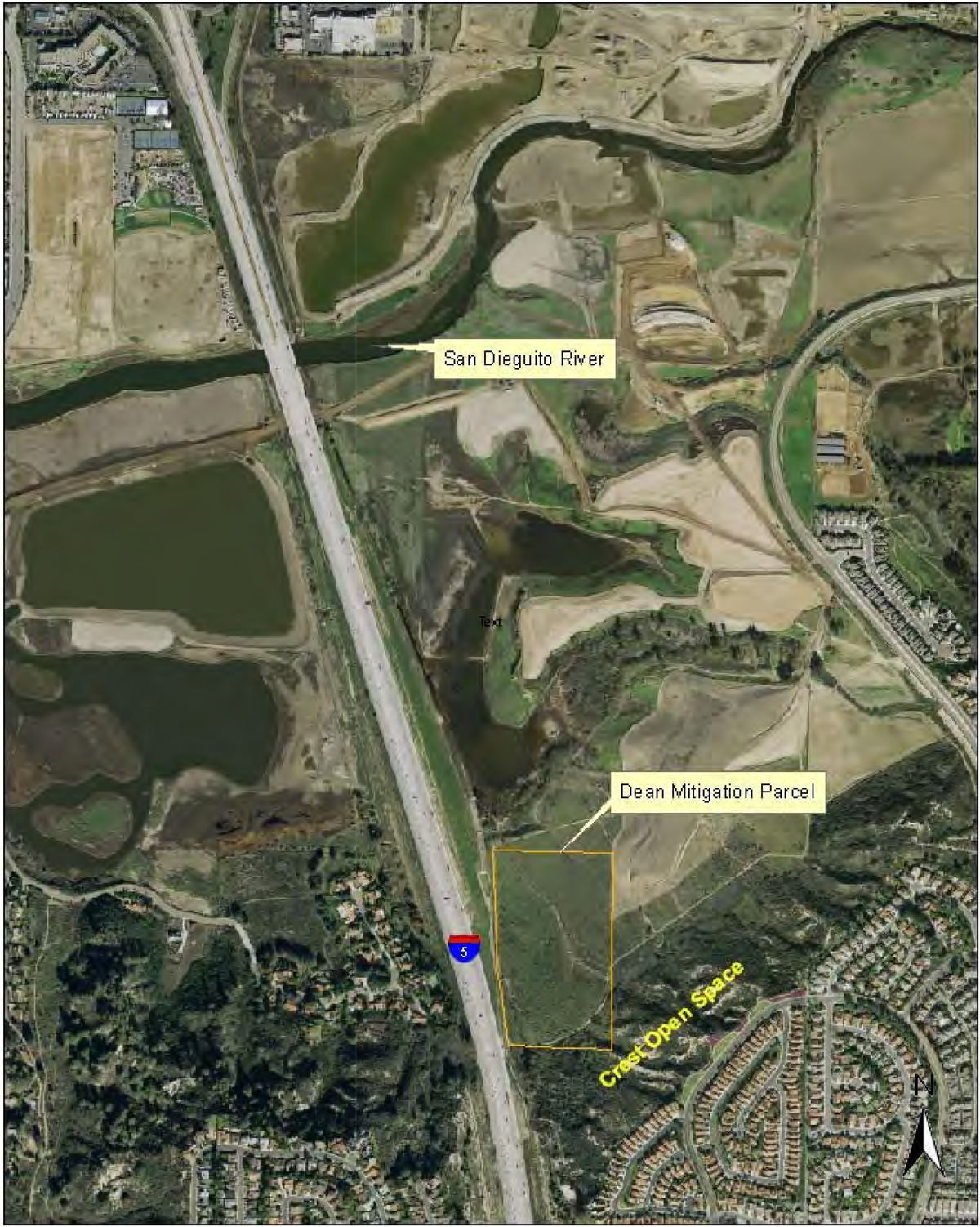
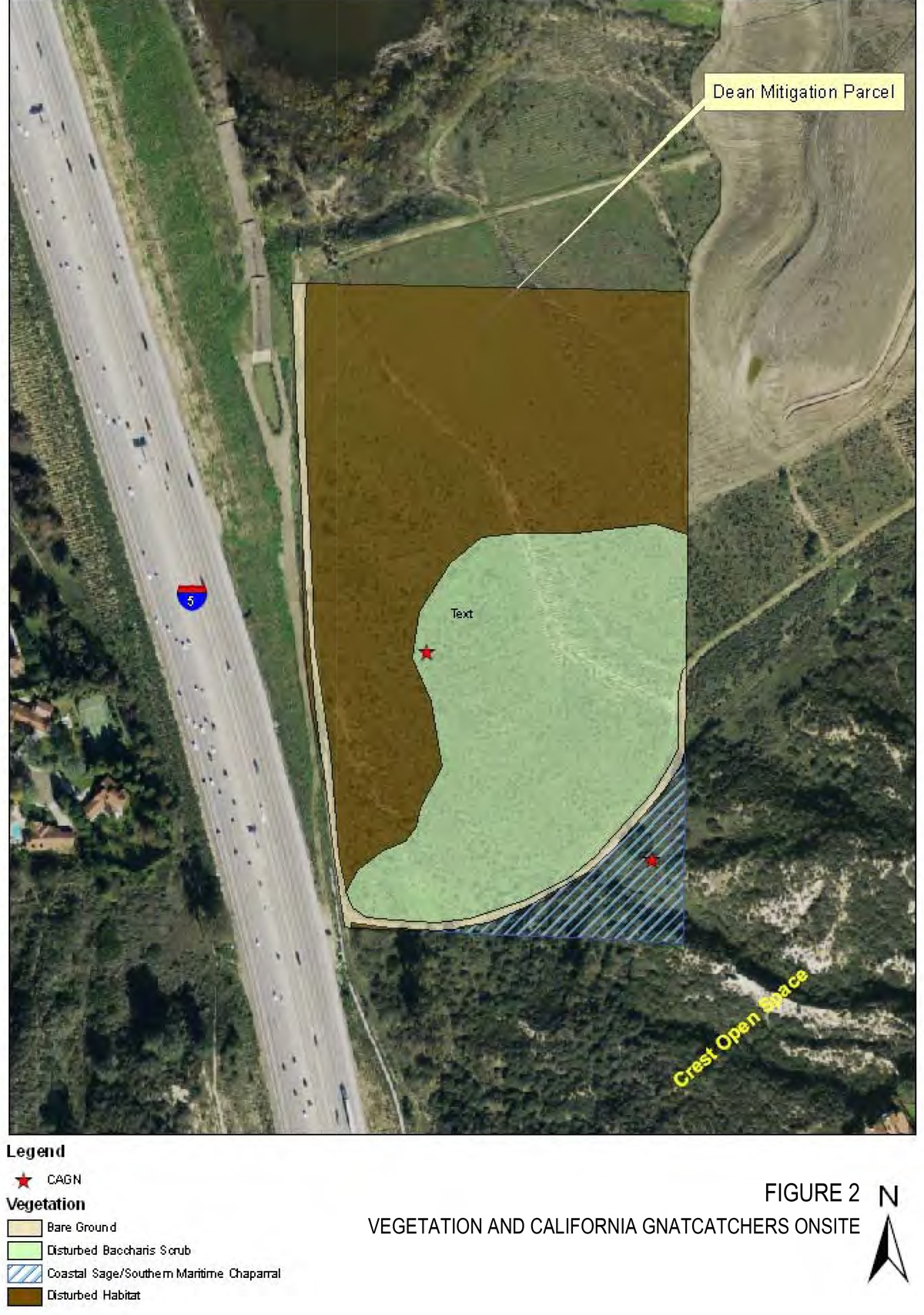


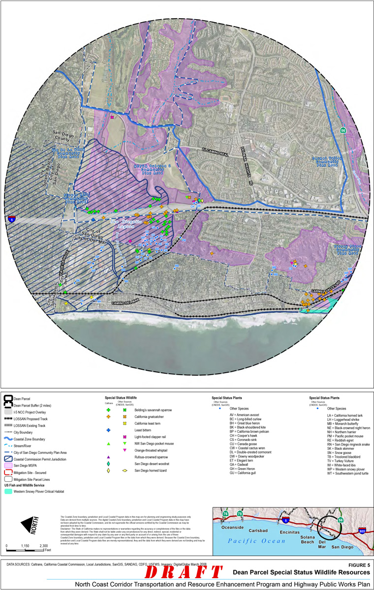
Deer Canyon II Site
- Site Location: The Deer Canyon II mitigation site is located south of State Route (SR) 56 and south of McGonigle Canyon (see Figure 1).
- Latitude/Longitude: 32º 57’ 1.2443 north and -117º 11’ 13.8728 west
- APN: Portions of 305-031-20 and 305-040-23 (22.2 acres)
- Ownership: California Department of Transportation (Caltrans) and the San Diego Association of Governments (SANDAG) is currently in negotiations to purchase the property from the owner. The purchase of the upper slope parcel has an agreed-upon price, is currently in escrow, and is anticipated to be complete in 2012.
- Correspondence with Resource Agencies: Agencies have approved wetland and upland mitigation on the lower parcel, and upland mitigation on portions of the upper parcel.
Mitigation Goal
SANDAG and Caltrans propose to mitigate impacts to sensitive upland habitats associated with the North Coast Corridor Public Works Plan/Transportation and Resource Enhancement Program (PWP/TREP) by enhancing poor quality upland habitat on the Deer Canyon II mitigation site, located in Deer Canyon adjacent to Deer Canyon Creek. The Deer Canyon II mitigation site consists of approximately 22.2 acres and is located adjacent to lands subject to a separate mitigation proposal for the I-5/Genesee Avenue Interchange Reconstruction Project, I-805 North Managed Lanes Project, Carroll Canyon Road Extension and Direct Access Ramp, and doubletracking projects on the LOSSAN corridor. For the North Coast Corridor PWP/TREP, only the upland creation/restoration located within the Upper Parcel slope of this larger mitigation area will be described herein (see Figure 2).
The goal of the upland creation in Deer Canyon is to create coastal sage scrub habitat in areas that are currently nonnative grassland and then manage the parcel as open space in perpetuity. The proposed creation and in-perpetuity management of the native uplands vegetation communities will:
- Provide wildlife habitat for the California gnatcatcher (Polioptila californica californica) and other native wildlife species habitat by removing nonnative grassland and converting it to high-quality coastal sage scrub habitat;
- Improve coastal sage scrub habitat and ecosystem continuity through connectivity between coastal wetlands and native uplands;
- Stabilize slopes in Deer Canyon by converting nonnative grassland habitat to more appropriate coastal sage scrub habitat;
- Provide a buffer between the riparian habitat and the surrounding land uses; and
- Preserve the restored areas in Deer Canyon as permanent open space.
Table 1: Habitat Mitigation Goals
| Habitat Types | Mitigation Type | Mitigation Acreage |
|---|---|---|
| Coastal sage scrub | Creation and Restoration | 14.6 ac. |
Existing Conditions
Ecological Context
The Deer Canyon II site is within the Peñasquitos Hydrologic Unit. In total, the Deer Canyon II site is approximately 22.2 acres in size, including the majority of the upper slopes of the larger Deer Canyon Mitigation site. The larger site is split into two parcels: 1) the lower portion that abuts the creek; and 2) the upland slopes to the north, where the upper parcel mitigation described herein is proposed to take place. Approximately 7.6 acres of the 22.2-acre upper parcel is already planned and approved for coastal sage scrub creation and preservation of some nonnative grassland for associated impacts to that habitat on coastal projects.
The Deer Canyon II site is within a Multiple Habitat Planning Area and is identified for preservation. California Natural Diversity Database (CNDDB) mapped resources for the upper parcel of the Deer Canyon Mitigation Site includes a variety of data points within a 2-mile radius (see Figure 3). Special status plant species identified within the 2-mile radius include California adolphia (Adolphia californica), wart stemmed ceanothus (Ceanothus verrucosus), summer holly (Comarostaphylis diversifolia), Del Mar manzanita (Arctostaphylos glandulosa ssp. crassifolia), and others as identified in Figure 4. Numerous special status wildlife species are also identified within a 2-mile radius of the Deer Canyon II site and include the California gnatcatcher (Polioptila californica) (see Figure 5). No sensitive species currently occur on the upper parcel due to its disturbed nature. However, California adolphia is immediately across (and north of) the dirt road from the upper parcel.
Drainage and Hydrology
Hydrology of the site consists primarily of overland drainage (sheet flow) and a few hillside drainages, which drain site runoff southerly to Deer Canyon Creek. Deer Canyon Creek is a small, ephemeral to the intermittent creek that is fed primarily by urban runoff, precipitation, and stormwater flows.
Soils
Soils located on the lower parcel are primarily sandy with some clay and silt, whereas the upper parcel consists of more clayey sands and clays. Locally, gravelly and cobbly layers were found within the lithologic unit (Caltrans 2011).
Vegetation
The majority of the upper parcel supports nonnative grassland habitat, with a few small patches of disturbed Diegan coastal sage scrub along the eastern and southern borders (see Figure 2). The nonnative grassland is comprised primarily of brome grasses (Bromus spp.), wild oat (Avena sp.), and barley (Hordeum spp.). The nonnative grassland habitat provides some wildlife and foraging habitat for common bird and mammal species.
Native species in the disturbed Diegan coastal sage scrub communities include deerweed (Lotus scoparius) and coyote bush (Baccharis pilularis); however, this habitat is dominated by nonnative grasses such as ripgut grass (Bromus diandrus), wild oat (Avena sp.), red brome (Bromus madritensis ssp. rubens), and barley (Hordeum spp.).
Disturbed habitat is found in portions of the upper parcel and concentrated to the east. The disturbed habitat is dominated by black mustard (Brassica nigra), filaree (Erodium sp.), tocalote (Centaurea melitensis) wild radish (Raphanus sativus), clover (Medicago sp.), sweet fennel, and horseweed (Conyza canadensis).
Nonnative grassland disturbed Diegan coastal sage scrub, and disturbed habitat communities were identified on the upper parcel. Overall, the parcel contains poor habitat, with weed invasion in most places. A summary of existing habitat types and acreage on the Deer Canyon II site is provided in Table 2 below.
Table 2: Existing Vegetation Communities
| Preserved Habitat Type | Mitigation Acreage |
|---|---|
| Disturbed Coastal Sage Scrub | 0.48 ac. |
| Disturbed Habitat | 0.6 ac. |
| Nonnative grassland | 21.12 ac. |
| Total | 22.2 ac. |
Wildlife
Bird species that were observed onsite include California towhee (Pipilo crissalis), song sparrow (Melospiza melodia), Cassin's kingbird (Tyrannus vociferans), and common yellowthroat (Geothlypis trichas) (Scatolini 2012). Northern harriers (Circus cyaneus) and white-tailed kites (Elanus leucurus) were observed foraging onsite.
One San Diego horned lizard (Phrynosoma coronatum blainvillii) was observed on the dirt road along the northern boundary of the site.
Prior and Current Land Use
The habitat creation on the upper parcel slopes will be adjacent to the upland and wetland mitigation immediately to the south on the Deer Canyon (I) Mitigation Site and additional coastal sage scrub creation that is already planned on a portion of the upper parcel (Caltrans 2011). There are additional riparian mitigation sites immediately to the west, north, and south of the upper parcel.
The fire road immediately north of the site at the top of the slope is used as a trail by horse-back riders, walkers, and mountain bikes.
Existing Utilities/Infrastructure/Easements
There are utility power lines immediately west of the project. There is a sewer easement along dirt roads to the west and south of the Deer Canyon parcels. There are no known utilities onsite.
Mitigation Program
The main goals of the mitigation are to provide wildlife habitat for the California gnatcatcher (Polioptila californica californica) and other native wildlife species habitat by removing nonnative grassland and creating high-quality coastal sage scrub habitat, improve coastal sage scrub habitat and ecosystem continuity through connectivity between coastal wetlands and native uplands, and preserve the restored areas in Deer Canyon as permanent open space. The coastal sage scrub habitat created onsite will also provide a buffer to the riparian habitat at the base of the slope in the adjacent mitigation areas, and provide slope stability and protection from erosion during rain events. The following program is intended to promote the established goals.
Schedule
The design of the mitigation plan will begin when full approval is received from the resource agencies that mitigation is appropriate at the Deer Canyon II site, and will be counted toward mitigating the North Coast Corridor multi-modal transportation program impacts. Detailed design will be provided through the Notice of Intent to Develop (NOID) approval process during the first phase of implementation of the North Coast Corridor PWP/TREP. As discussed in Section 6.5.3 of the PWP/TREP, the results of consultations with persons and agencies interested in, with jurisdiction over, and/or affected by the proposed development, including consultations with federal and state resource agencies (e.g., USFWS, CDFG, etc.), as well as all supporting documentation are required to be submitted along with the NOID project report. Accordingly, all design and related project reporting would be submitted to the permitting agencies for consultation as part of the NOID review and approval process.
Mitigation Goal and Purpose
Upland mitigation will create Diegan coastal sage scrub in existing nonnative grassland habitat onsite. The creation will include exotic control, dethatching, container planting, seeding, and will likely use temporary irrigation.
Hydrology
Upland hydrology will primarily be maintained as overland sheet flow and within the existing hillside drainages that currently exist. However, some minimal topographic modifications and/or appropriate Best Management Practices (BMPs) will be implemented in upland areas if necessary to reduce concentrated runoff and erosive conditions.
Topographic Modification
SANDAG/Caltrans do not propose to re-contour or grade the site. Appropriate BMPs would be implemented on the site, as needed, to minimize erosion and sedimentation. BMPs may include the use of fiber rolls, erosion control textiles, and fiber mulch products to hold soil in place until vegetation density and cover are established.
Site Preparation
The nonnative grassland onsite will be dethatched and sprayed with the herbicide prior to planting.
After dethatching and before seeding and planting, a grow/kill program involving two or more watering events using a temporary irrigation system or watering truck followed by a kill/herbicide application shall be implemented to reduce the nonnative seed bank. All nonnative plant material will be taken offsite and disposed of properly. Prior to hydroseed installation, soil testing will be conducted to test viability; fertilizer will be incorporated into the slurry mix per soil test results and recommendations.
Target Plant Communities
Table 3 contains a list of container species that will be used onsite. Table 4 contains a list of coastal sage scrub species that will be hydro-seeded on all coastal sage scrub planting areas. Hydroseeding of the non-irrigated slopes will occur between October and February to take advantage of the rainy season.
Table 3: Coastal Sage Scrub Species to be Planted on the Slope
| Scientific Name | Common Name | Container Size |
|---|---|---|
| Rhus integrifolia | lemonadeberry | 1 gallon |
| Heteromeles arbutifolia | toyon | 1 gallon |
| Artemisia californica | coastal sagebrush | 1 gallon |
| Salvia mellifera | black sage | 1 gallon |
| Salvia apiana | white sage | 1 gallon |
| Isomeris arborea | bladderpod | 1 gallon |
| Mirabilis californica | four o’clock | 1 gallon |
| Encelia californica | California sunflower | 1 gallon |
| Leymus condensatus | giant wild rye | 1 gallon |
| Cylindopuntia prolifera | coast cholla | 1 gallon |
Table 4: Hydroseed for Coastal Sage Scrub Enhancement Area
|
Scientific Name |
Common Name | Percent Germination (Minimum) | Pounds Pure Live Seed per Acre |
|---|---|---|---|
| Artemisia californica | coastal sagebrush | 40 | 1.0 |
| Bromus carinatus | California brome | 70 | 2.0 |
| Camissonia cheiranthifolia | Beach evening-primrose | 65 | 1.0 |
| Castilleja exserta | purple owl’s clover | 40 | 1.0 |
| Clarkia purpurea quadivulnera | four spot clarkia | 65 | 0.5 |
| Encelia californica | California sunflower | 50 | 1.0 |
| Eriogonum fasciculatum var. fasc. | flat-topped buckwheat | 55 | 3.0 |
| Deinandra fasciculata | fascicled tarweed | 15 | 2.0 |
| Lupinus bicolor | Miniature lupin | 70 | 2.0 |
| Lupinus succulentus | Arroyo lupin | 75 | 2.0 |
| Gnaphalium californicum | California everlasting | 15 | 0.25 |
| Lasthenia californica | goldfields | 50 | 2.0 |
| Lotus scoparius | deerweed | 50 | 2.5 |
| Nassella pulchra | purple needlegrass | 50 | 6.0 |
| Salvia apiana | White sage | 40 | 1.0 |
| Sisyrinchium bellum | Blue-eyed grass | 65 | 1.0 |
| Salvia mellifera | black sage | 40 | 2.0 |
Supportive Measures
Temporary irrigation will likely be used to initiate a nonnative grow/kill program to reduce the nonnative seed bank onsite prior to hydroseeding and planting. Temporary irrigation will likely also be used for the first year or two to get the container plants established. Maintenance and monitoring will be performed during the 5-year monitoring period to guide the emerging native vegetation toward meeting performance standards. Maintenance onsite will require several years of intense weed removal through hand pulling and spraying with herbicide (glyphosate) to control the nonnative grasses and allow the coastal sage scrub species to become established.
Performance Criteria
Performance criteria will be developed from reference sites within or adjacent to the mitigation parcel and will be established to match the reference habitats. Other performance criteria will include native seedling recruitment, non-native vegetation cover, soil stability (lack of erosion), and wildlife use of the area. Criteria will be established that provides a high level of confidence that, once performance criteria are achieved, the resultant vegetation communities will be resilient and persistent as a demonstration of self-sustainability under a long term management program.
Mitigation results for uplands are expected to increase native cover and species diversity to around 85% of reference habitat while reducing non-native annual cover to 5% or less of total vegetation cover. The specifics of the performance criteria will be detailed in the Conceptual Mitigation Plan for the Deer Canyon II Site, through the NOID process and/or Coastal Development Permit. Presently, the mitigation site is dominated by non-native vegetation.
Site Protection
Caltrans will deed the site to the City of San Diego with a fully funded endowment, once the mitigation projects have reached the end of the interim maintenance period and satisfy established performance criteria. A management endowment account will be established once the property acquisition is complete. The endowment funds will be used by the management entity to monitor and maintain site access restrictions and habitat quality. The upper parcel, once restored, is intended to be preserved in a natural, scenic, open condition to maintain its ecological, historical, visual and educational values.
Site restrictions might be required to fully protect existing biological resources from local residential land use and motorists at the viewpoint parking area. Any fence installed will be maintained as part of land management.
Long Term Management
A Habitat Management Plan (HMP) will be prepared to define the long term management responsibilities to maintain the functions and services of the preserved biological resources. The City of San Diego will assume long term management responsibilities. Funds for long term management will be provided by SANDAG/Caltrans and placed into a non-wasting endowment. Endowment funds will be established using a Property Assessment Report that is based on the approved HMP.
Anticipated potential management issues related to this parcel include site access control, weed control, trash accumulation control.
Additional Studies
Further studies will be required to support the final design to be presented in the NOID submittal. These studies include soil testing to determine if there are any nutrient deficiencies. Cultural resource studies have already been completed and no resources were identified. In addition, a reference site with appropriate coastal sage scrub will be identified and sampled using line-transect methods to obtain vegetation community data such as cover, density, and species diversity.
Required Permits
A NOID with accompanying project report will likely be required for project implementation.
References
- CalIPC. 2012. Website http://www.cal-ipc.org/ip/management/ipcw/categories.php, accessed May 4, 2012.
- Caltrans. 2011. Final Compensatory Wetland/Upland Mitigation Plan for Deer Canyon. May 2011.
- Scatolini, Susan. 2012. Email correspondence occurring on May 2, 2012.
North Coast Corridor Mitigation Site Assessment for the Deer Canyon II Site
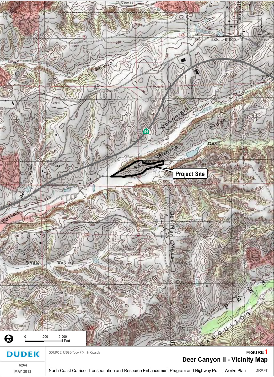
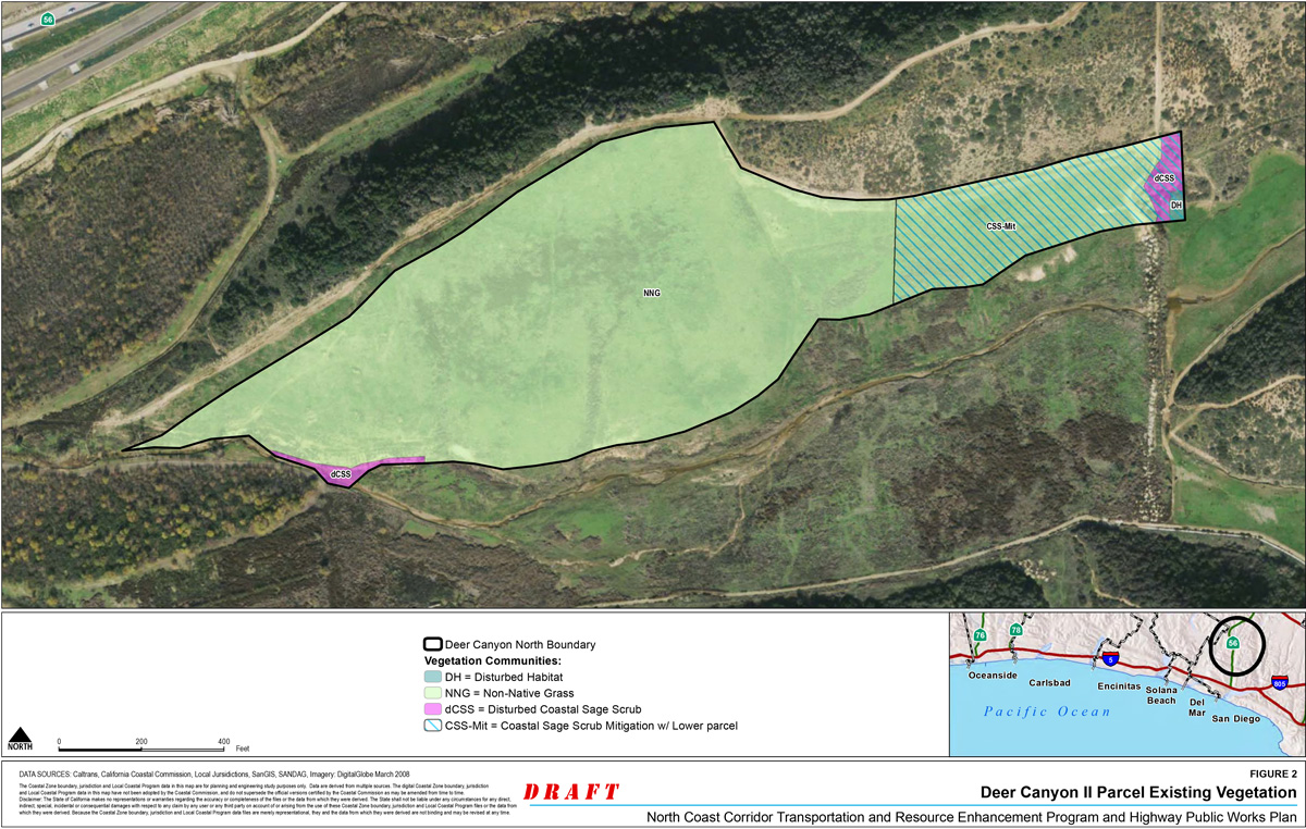
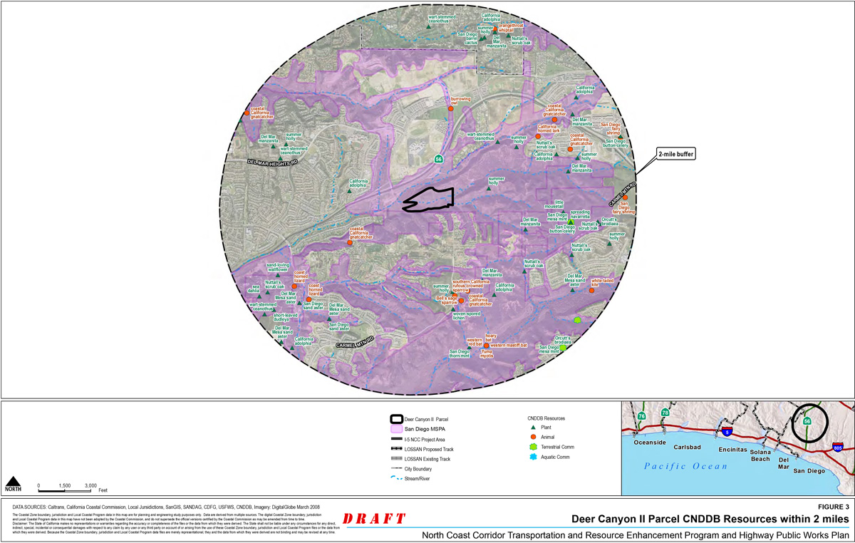
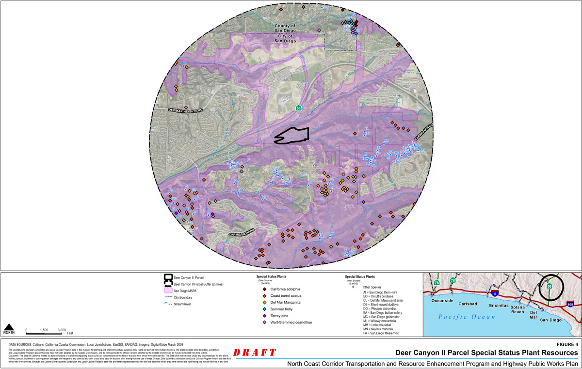
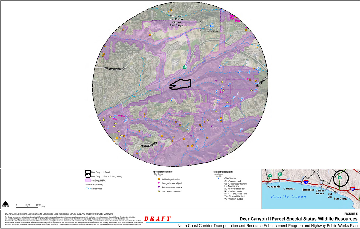
Costa Preservation Parcel
- Site Location: The La Costa preservation parcel is located east of Interstate 5 (I-5), south of La Costa Avenue and east of Piraeus Street (see Figure 1). The parcel is situated across La Costa Avenue from Batiquitos Lagoon.
- Latitude/Longitude: 33.0878/-117.2896
- APN: 216-110-31 (19.75 acres)
- Ownership: Caltrans has purchased this parcel
- Correspondence with Resource Agencies: June 2008, Resource agencies receive a request from Caltrans and SANDAG to approve the site for acquisition; Letters acknowledging consideration of a site for mitigation received from CCC March 2009, CDFG July 2008, USFWS August 2008, and NMFS July 2008.
Mitigation Goal
The San Diego Association of Governments (SANDAG) and California Department of Transportation (Caltrans) proposes to mitigate impacts to sensitive upland habitats associated with the North Coast Corridor Public Works Plan/Transportation and Resource Enhancement Program (PWP/TREP) of multi-modal transportation projects by preserving and managing existing high-quality uplands habitat on the La Costa preservation parcel located along the south shore of Batiquitos Lagoon (see Figure 2). The goal of the preservation acquisition and mitigation program is to remove the development potential of the parcel, enhance disturbed Coastal Sage Scrub (CSS) areas through rehabilitation efforts, preserve existing high-quality upland habitat through site protection (easements and fence), and manage the parcel in perpetuity.
The proposed preservation and management of the native uplands vegetation communities will preserve:
- Occupied California gnatcatcher habitat by removing extant habitat from the threat of development;
- Chaparral and coastal sage scrub habitat and ecosystem continuity through connectivity between coastal wetlands and native uplands;
- Sensitive plants and cultural resources onsite;
- Wildlife connectivity with Batiquitos Lagoon and surrounding native open space that connects to Encinitas Creek and other drainages into the lagoon and out to the Pacific coastline; and,
- Natural topography adjacent to Batiquitos Lagoon that is highly visible from the I-5 corridor and significantly contributes to the scenic quality and landscape character.
The proposed rehabilitation of the disturbed CSS communities will involve:
- The removal of nonnative species from areas mapped as disturbed CSS
- Replanting and/or hydroseeding disturbed areas with appropriate native species.
Existing Conditions
Ecological Context
The parcel was identified as consisting of high to very high habitat values in the Multiple Habitat Conservation Plan (MHCP) for coastal northern San Diego County and is located within a Biological Core Linkage area. The preservation area abuts the Carlsbad HCP core area #8 that comprises Batiquitos Lagoon. The lagoon is owned and managed by the California Department of Fish and Game. California Natural Diversity Database (CNDDB) mapped resources for these adjacent uplands to Batiquitos Lagoon includes a variety of nearby data points (Figure 3). Special status plant species identified onsite include California adolphia (Adolphia californica) and wart stemmed ceanothus (Ceanothus verrucosus), while sea dahlia (Coreopsis maritima) and Del Mar sand aster (Lessingia filaginifolia var. linifolia) have been identified nearby (Figure 4). Numerous special status wildlife species are also identified within and adjacent to Batiquitos Lagoon (Figure 5), and critical habitat for the California gnatcatcher is designated on the entirety of the parcel. Adjacent upland areas, including the subject parcels, are utilized by California gnatcatcher.
Other open space lands are present south and east of the preservation parcel. These open space areas are located on slopes and canyons that topographically form the southern boundary of Batiquitos Lagoon. These slopes provide linkages to inland areas associated with Encinitas Creek and other drainages that flow into the lagoon and ultimately connect to the Pacific.
Soils
The acquired parcel consists of steep north and northwest facing slopes. Three soil types are present on the parcel including Carlsbad gravelly loamy sand at the base of the slope, Gaviota fine sandy loam on the steepest slopes, and Corralitos loamy sand on the mesa top (NRCS, Web Soil Survey).
Vegetation
Diegan coastal sage scrub, chaparral (both southern maritime chaparral and chamise chaparral), and disturbed habitat communities were identified on the parcel. The parcel has good habitat with excellent habitat found on the top of the mesa. It provides habitat for sensitive plants as well as the threatened California gnatcatcher and supports rare plants and communities. There is little weed invasion in most places, and minimal effort would be needed to fence these parcels to control access and preserve the habitat in place.
A general description of each community and a description of its occurrence within the parcel is provided below.
Diegan Coastal Sage Scrub. This vegetation type was once widespread in coastal southern California, and now it occurs in patches from Los Angeles into Baja California. This plant community on the parcel totals about 11.75 acres and is composed of a variety of low, soft aromatic shrubs dominated by drought-deciduous species such as California sagebrush (Artemisia californica), flat-topped buckwheat (Eriogonum fasciculatum var. fasciculatum), white sage (Salvia apiana), and black sage (Salvia mellifera). Coastal sage scrub (CSS) on-site is dominated by California sagebrush and buckwheat with prickly pear (Opuntia littoralis), laurel sumac (Malosma laurina), lemonade berry (Rhus integrifolia), black sage, desert elderberry (Sambucus Mexicana), California sunflower (Encelia californica), and golden yarrow (Eriophyllum confertifolium var. confertifolium) (Figure 2). California adolphia (Adolphia californica), a sensitive plant, occurs in this community on site. The top of the mesa is relatively densely vegetated except along walking trails. The top of the slope on the northern end of the mesa has patches that are more disturbed with nonnative grasses and weedy annuals including ripgut grass (Bromus diandrus), foxtail chess (Bromus madritensis var. rubens), mustard (Brassica sp.), and ice plant (Carpobrotus edulis).
The base of the canyon on the northeastern end of the parcel consists of approximately 3.65 acres of disturbed coastal sage scrub dominated by coyote bush (Baccharis pilularis), California sunflower, and black sage with large patches of fennel (Foeniculum vulgare).
Chaparral. Two types of chaparral are found on-site including chamise chaparral and southern maritime chaparral. There is approximately 3.38 acres of chaparral on site. Chamise chaparral is dominated by chamise (Adenostoma fasciculatum) in dense almost monotypic stands. This is a fire-adapted community that is found primarily on east-facing slopes. Chamise chaparral on-site occurs in small patches on north-facing slopes of the parcel.
Southern maritime chaparral occurs on the upper north-facing slopes at the western end of the parcel and the north-facing slopes of the canyon. This community is dominated by wartstemmed ceanothus (Ceanothus verrucosus) with chamise, toyon (Heteromeles arbutifolia), laurel sumac, fuchsia-flowered gooseberry (Ribes speciosum), mission manzanita (Xylococcus bicolor), and Mohave Yucca (Yucca schidigera). Elements of Diegan coastal sage scrub are interspersed within this community.
A summary of existing habitat types and acreage on the La Costa parcel is provided in Table 1, below.
Table 1: Preservation Acreage by Habitat Type
| Preserved Habitat Type | Mitigation Acreage |
|---|---|
| Coastal Sage Scrub | 11.75 ac. |
| Disturbed Coastal Sage Scrub | 3.65 ac. |
| Chaparral | 3.38 ac. |
| Disturbed Habitat (Coastal Sage Scrub Enhancement) | 0.97 ac. |
| Total | 19.75 ac. |
Wildlife
One pair of threatened coastal California gnatcatcher (Poliptila californica californica) was observed at the top of the parcel (see Figures 2 and 5). Other bird species that were observed on-site include California towhee (Pipilo crissalis), song sparrow (Melospiza melodia), Anna's hummingbird (Calypte anna), bushtit (Psaltriparus minimus), and California thrasher (Toxostoma redivivum). Other wildlife species observed on-site include coyote (Canis latrans), western fence lizard (Sceloporus occidentalis), desert cottontail (Sylvilagus audubonii), and California ground squirrel (Spermophilus beecheyi).
Prior and Current Land Use
The parcel is adjacent to La Costa Avenue on the north. Piraeus Street is located to the west and Sky Loft Road to the south. La Costa Avenue is a four-lane road with high traffic speeds and no roadside parking. Access from La Costa Avenue is extremely limited and roadside parking is dangerous. Limited parking is available on the shoulder of Piraeus Street adjacent to the south at the intersection with La Costa Avenue. Roadside parking along Sky Loft Road is limited by an asphalt curb that runs the length of this road up to the existing residential development.
Some informal hiking trails are present on the parcel. These trails appear to be used to access high points that provide vistas of Batiquitos Lagoon and the Pacific Ocean. Due to the lack of parking, these trails are likely used only by residents.
Existing Utilities/Infrastructure/Easements
There are no known utilities, infrastructure, or easements located on the parcel that could affect the implementation of the proposed mitigation/preservation opportunity (see Figure 6).
Mitigation Program
The proposed mitigation for the entirety of the site will be for protected open space, habitat preservation, and management. The goal of the preservation acquisition is to remove the development potential of the parcel, preserve existing upland habitat through site protection (easements and fence), and ensure management in perpetuity.
Rehabilitation
Areas that are mapped as disturbed CSS will be rehabilitated through the removal of nonnative species and the replanting and/or seeding with an appropriate native CSS plant palette.
Target Plant Communities
The design and plant palette used to rehabilitate the disturbed CSS areas will include native species found in adjacent native areas. To provide appropriate native species diversity that is comparable to adjacent high-quality habitat, additional field surveys of the La Costa Parcel, detailing annual and perennial species will need to occur and the recorded species added to the plant palette in the NOID submittal, as appropriate.
Site Protection
Caltrans will deed the preservation parcel to a local land management agency that is acceptable to the resource agencies. A management endowment account will be established once the property acquisition is complete. The endowment funds will be used by the management entity to monitor and maintain site access restrictions and habitat quality.
Site restrictions might be required to fully protect existing biological resources. However, some controlled access opportunities for residents to access vistas should be considered to minimize vandalism on the preserved land. Any fence installed will be maintained as part of the preserved land management.
Long Term Management
A Habitat Management Plan (HMP) will be prepared to define the long term management responsibilities to maintain the functions and services of the preserved biological resources. A resource agency-approved management entity will assume long term management responsibilities. Funds for long term management will be provided by SANDAG/Caltrans and placed into a non-wasting endowment. Endowment funds will be established using a Property Assessment Report that is based on the approved HMP.
Anticipated potential management issues related to this parcel include site access control, weed control, trash accumulation control.
Additional Studies
Rehabilitation of disturbed CSS areas may occur as a portion of the proposed mitigation program for the La Costa Parcel. Additional field surveys of the La Costa Parcel will need to occur to determine appropriate plant palettes to be used in the rehabilitation efforts onsite.
Required Permits
No permits are anticipated to be required to implement site protection and management actions.
North Coast Corridor Mitigation Site Assessment for the Costa Preservation Parcel

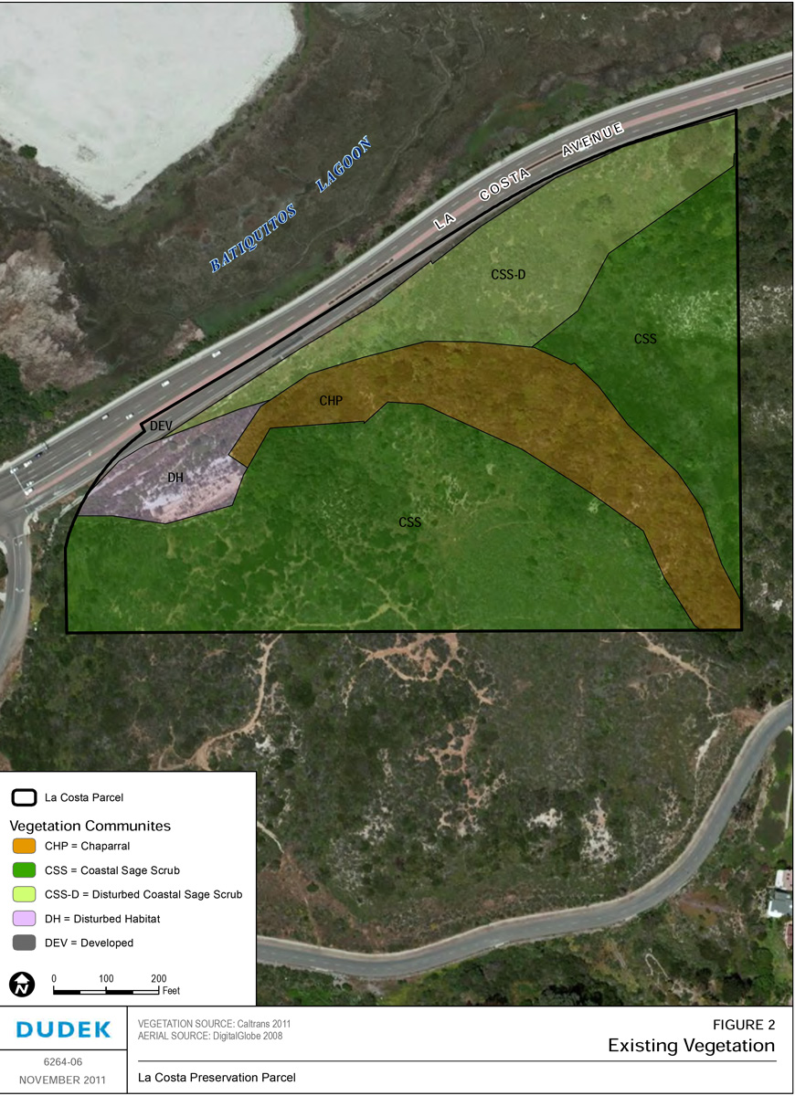
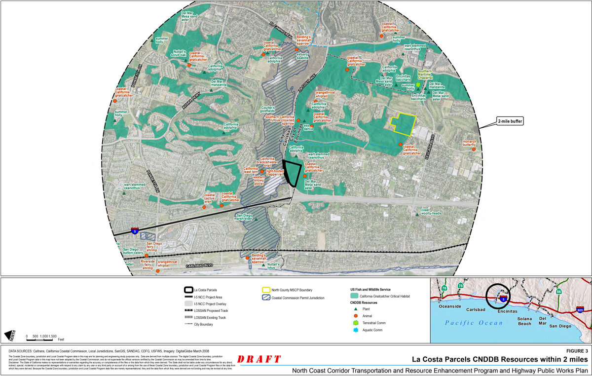


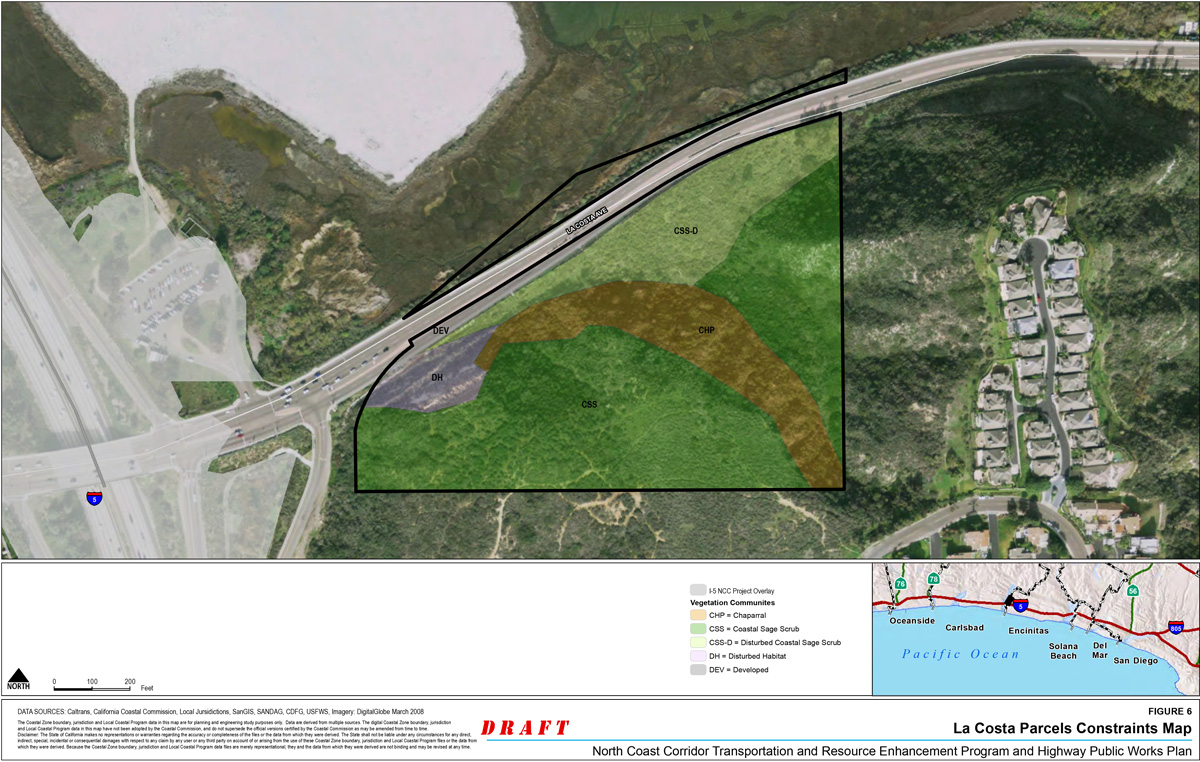
Laser Preservation Parcels
- Site Location: The Laser Preservation Parcels (Laser parcels) are located west of Interstate 5 (I-5) and north and east of Manchester Avenue (see Figure 1). The parcels are situated across Manchester Avenue from San Elijo Lagoon.
- Latitude/Longitude: 33.0878/-117.2896
- APNs: 260-200-21-00 (1.88 acres) and 260-200-03-00 (3.1 acres)
- Ownership: Caltrans has purchased these parcels
- Correspondence with Resource Agencies: Resource agencies were made aware of the site purchase during NEPA 404 coordination meetings held in 2011 and 2012, and letters received on March 17, 2011, from USFWS and CDFG regarding consideration of the Laser parcels for mitigation.
Mitigation Goal
The San Diego Association of Governments (SANDAG) and California Department of Transportation (Caltrans) propose to mitigate impacts to sensitive upland habitats associated with the multi-modal transportation projects permitted under the North Coast Corridor Public Works Plan/Transportation and Resource Enhancement Program (PWP/TREP) by rehabilitating, preserving, and managing existing uplands habitat on the Laser parcels located immediately north of San Elijo Lagoon. The goal of the mitigation program on the Laser Parcel is to remove the development potential of the parcels, preserve existing upland habitat through site protection (easements and fence), improve habitat value through the removal of non-native species in areas adjacent to the lagoon, and ensure management in perpetuity.
The proposed preservation and management of the native uplands vegetation communities will preserve:
- Occupied California gnatcatcher habitat (two territories);
- Coastal sage scrub and coastal bluff scrub habitat and ecosystem continuity through connectivity between coastal wetlands and native uplands;
- Sensitive plants onsite;
- An increased native upland buffer between I-5 and San Elijo Lagoon and surrounding native open space that connects to Encinitas Creek and other drainages into the lagoon and out to the Pacific coastline; and
- Natural topography adjacent to San Elijo Lagoon that is highly visible from the I-5 corridor and significantly contributes to the scenic quality and landscape character.
The proposed rehabilitation of the ornamental adjacent to Manchester Avenue and the disturbed CSS communities throughout the Parcel will involve:
- The removal of nonnative species from areas mapped as ornamental adjacent to Manchester Avenue and areas mapped as disturbed coastal sage scrub (CSS).
- Replanting and/or hydroseeding ornamental planting and disturbed CSS areas with appropriate native species.
Existing Conditions
Ecological Context
The Laser parcels were determined to support a range of habitat values (low to high) immediately adjacent to the Multiple Habitat Conservation Plan (MHCP) area for coastal northern San Diego County. The site is located within a Biological Core Linkage area. The parcels are located adjacent to the Coastal Zone and within critical habitat for California gnatcatcher (see Figure 2). California Natural Diversity Database (CNDDB) mapped resources for these adjacent uplands to San Elijo Lagoon include nearby data points for northwestern San Diego pocket mouse (Perognathus fallax fallax), Palmer's grapplinghook (Harpagonella palmeri), and sand-loving wallflower (Erysimum ammophilum) (see Figure 3). Special status plant species observed onsite include California adolphia (Adolphia californica), sea dahlia (Coreopsis maritima), and Del Mar sand aster (Lessingia filaginifolia var. linifolia), while San Diego barrel cactus (Ferocactus viridescens) was observed nearby (see Figure 4). Numerous special status wildlife species are also identified within and adjacent San Elijo Lagoon (see Figure 5). Adjacent upland areas, including the subject parcels, are utilized by California gnatcatcher.
Soils
The acquired parcels consist of steep west-facing slopes. The soil on these parcels consists of terrace escarpment soils (NRCS, Web Soil Survey). The soil texture appears to be a sandy loam that is moderately erodible. There are areas where sandstone parent material is exposed.
Two areas of minor erosion that total 0.06 acre are present on the northern portion of the site. These erosion features are remnant off-road vehicle and bike trails that predate the adjacent residential development on the west. The residential development truncated these trails. Presently, there appears to be limited access to these trails by residents. Although some native recruitment is present, the bare ground area does not appear to provide sufficient soil resources for natural recruitment to passively reclaim these areas. The severity of erosion features observed within these areas is low due to soil substrate texture.
Vegetation
Diegan coastal sage scrub, coastal bluff scrub, nonnative grassland, disturbed habitat, bare ground, and ornamental communities were identified on the two parcels. In addition, a small area of disturbed salt marsh and developed habitats were observed adjacent to Manchester Avenue. A general description of each community and a description of its occurrence within the parcels are provided below.
- Diegan Coastal Sage Scrub. This vegetation type was once widespread in coastal southern California, and now it occurs in patches from Los Angeles into Baja California. This vegetation community is composed of a variety of low, soft aromatic shrubs dominated by drought-deciduous species such as California sagebrush (Artemisia californica), flat-topped buckwheat (Eriogonum fasciculatum var. fasciculatum), white sage (Salvia apiana), and black sage (Salvia mellifera). Coastal sage scrub onsite is dominated by California sagebrush and buckwheat with prickly pear (Opuntia littoralis), laurel sumac (Malosma laurina), lemonadeberry (Rhus integrifolia), black sage, and California sunflower (Encelia californica) (see Figure 2). The following sensitive plants occur in this community onsite, California adolphia (Adolphia californica), San Diego barrel cactus (Ferocactus viridescens), south coast saltscale (Atriplex Pacifica), and Del Mar sand aster (Lessingia filaginifolia var. linifolia). There are approximately 2.6 acres of coastal sage scrub on-site (see Table 1).
- Disturbed Coastal Sage Scrub. The upper portions of the parcels closer to I-5 and the utility access roads are dominated by disturbed coastal sage scrub. There are 1.32 acres of disturbed coastal sage scrub on-site (see Table 1). Disturbed coastal sage scrub is dominated by the same native species with nonnative grass, mustard (Brassica sp.), fennel (Foeniculum vulgare), tobacco tree (Nicotiana glauca), and other nonnative species annuals. In particular, non-native veldtgrass (Ehrharta sp.) appears to be spreading within the disturbed coastal sage scrub areas and on adjacent parcels. Veldtgrass is a perennial grass found along California's coastline. Veldtgrass is commonly found in disturbed areas, including riparian areas, scrub, grassland, woodland, urban areas and turf. Veldtgrass causes more litter accumulation than native grasses and herbs do, which further inhibits native plant growth (CALIPC website; http://www.cal-ipc.org/ip/management/plant_profiles/Ehrharta_erecta.php).
- Coastal Bluff Scrub. Coastal bluff scrub is a plant community made up primarily of low, prostrate plants that are wind pruned by sea breezes. Dominant plants in this community are primarily woody and/or succulent (Holland 1986). Species commonly found in this community include sea dahlia (Coreopsis maritima), live forevers (Dudleya spp.), lemonadeberry, and prickly pear. Coastal bluff scrub was identified in the southern portion of the smaller parcel. There are approximately 0.5 acres of coastal bluff scrub on the parcels. Sea dahlia and Orcutt's pincushion (Chaenactis glabriuscula var. orcutiana) are sensitive plant species that were found in this community onsite.
- Non-native Grassland. Non-native grassland is generally dominated by annual non-native species of grass including wild oat (Avena sp.), ripgut grass, foxtail chess, and others. Non-native grassland occurs in two small patches on-site totaling 0.16 acres (see Table 1)
- Other Communities. The remainders of the parcels are composed primarily of bare ground and ornamental landscaping. Bare ground areas are found on trails and near the edges of the roads. These areas have less than 10 percent cover and most of what does grow on these compacted soils are weedy species. The disturbed habitat is dominated by black mustard (Brassica nigra), ice plant (Carpobrotus edulis), tobacco tree, and yellow sweet clover (Melilotus indica). Ornamental landscaping is found near Manchester Avenue and is dominated by ice plant. There is also a small sliver of developed habitat on the shoulder of Manchester Avenue and a small remnant patch of disturbed salt marsh.
Table 1 includes the type and acreage of habitat to be preserved on the Laser parcels.
Table 1: Preservation Acreage by Habitat Type
|
Habitat Type |
Mitigation Acreage |
|---|---|
| Coastal Sage Scrub | 2.6 ac. |
| Disturbed (Coastal Sage Scrub Enhancement) | 1.32 ac. |
| Coastal Bluff Scrub | 0.5 ac. |
| Non-native Grassland | 0.16 ac. |
| Bare Ground | 0.11 ac. |
| Developed | 0.06 ac. |
| Disturbed Salt Marsh | 0.02 ac. |
| Ornamental | 0.21 ac. |
| Total | 4.98 ac. |
Wildlife
Two territories of threatened coastal California gnatcatcher (Poliptila californica californica) were observed, one on each parcel (see Figure 2). Other bird species that were observed onsite include California towhee (Pipilo crissalis), song sparrow (Melospiza melodia), Anna's hummingbird (Calypte anna), bushtit (Psaltriparus minimus), wrentit (Chamaeafasciata) and red-tailed hawk (Buteo jamaicensis). Other wildlife species detected onsite include coyote (Canis latrans), western fence lizard (Sceloporus occidentalis), desert cottontail (Sylvilagus audubonii), and California ground squirrel (Spermophilus beecheyi).
Prior and Current Land Use
Access to the Laser parcels is limited. Access to an existing pump station adjacent to I-5 may currently be used to access these parcels.
Some informal hiking trails are present on the parcel. These trails appear to be used to access high points that provide vistas of San Elijo Lagoon and the Pacific Ocean. Due to the lack of parking, these trails are likely used only by residents and occasionally by motorists who make use of the nearby scenic viewpoint parking area associated with I-5. However, the viewpoint is fenced to discourage trespassing on this property.
Constraints/Existing Utilities/Infrastructure/Easements
There are access roads for the San Dieguito Water District pump station and reclamation plant crossing the northernmost portion of the site. In addition, due to proximity of residential land uses to the north and south of the Laser parcels, it is possible that a portion of the 100-foot fuel modification zone could extend into a small corner of the total site area available for habitat preservation and management, although it is currently high quality coastal sage scrub habitat (see Figure 6). If the 100-foot fuel modification zone does extend into a small corner of the total site area, these zone areas are not included in the restoration totals of the site. Treatment of the 100-foot fuel modification zone will be consistent with fire protection standards for plant density, vegetation height, and reduced cover using appropriate fire-resistant plantings.
A small area of the Laser Preservation Parcel could be impacted by the eventual widening of Interstate 5. Any portion of the property affected by the future widening of Interstate 5 is not included in the restoration totals of the site.
Mitigation Program
The proposed mitigation for the entirety of the site will be for protected open space, habitat preservation, and management. The goal of the preservation acquisition is to remove the development potential of the parcels, preserve existing upland habitat through site protection (easements and fence), and ensure management in perpetuity.
Rehabilitation
Native species will be rehabilitated in areas that are currently mapped as ornamental and as disturbed CSS but are not deed restricted or located within fire buffer areas, through the removal of the nonnative species and the replanting with appropriate native species. Adjacent native areas will be preserved, as outlined herein.
Removal of the ornamental plant species along Manchester Avenue and the replacement with native species will enhance the functions and services of the preserved upland and wetland buffer by preventing future encroachment of the ornamental species into the San Elijo Lagoon.
Target Plant Communities
The design and plant palette used to rehabilitate the ornamental and disturbed CSS areas will include native species found in adjacent native areas. To provide appropriate native species diversity that is comparable to adjacent high-quality habitat, additional field surveys of the Laser Parcel, detailing native annual and perennial species will need to occur and the recorded species added to the plant palette in the NOID submittal, as appropriate.
Site Protection
Caltrans will deed the preservation parcels to an approved local land management agency that is acceptable to the resource agencies. A management endowment account will be established once the property acquisition is complete. The endowment funds will be used by the management entity to monitor and maintain site access restrictions and habitat quality
Site restrictions might be required to fully protect existing biological resources from local residential land use and motorists at the viewpoint parking area. The viewpoint will be fenced and the fence would be maintained by Caltrans. Any additional fence installed will be maintained as part of the land management.
Long Term Management
A Habitat Management Plan (HMP) will be prepared to define the long term management responsibilities to maintain the functions and services of the preserved biological resources. A resource agency-approved management entity will assume long term management responsibilities. Funds for long term management will be provided by SANDAG/Caltrans and placed into a non-wasting endowment. Endowment funds will be established using a Property Assessment Report that is based on the approved HMP.
Anticipated potential management issues related to this parcel include site access control, weed control, and trash accumulation control.
Additional Studies
If some portion of the Laser Property may be affected by the future widening of Interstate 5, mitigation acreages available on the property would be adjusted to remove impact areas. This acreage change will be documented in the text and figures of the Conceptual Mitigation Plan for the Laser Parcel.
Enhancement of ornamental planting and disturbed CSS areas may occur as a portion of the proposed mitigation program for the Laser Parcel. Additional field surveys of the Laser Parcel will need to occur to determine appropriate plant palettes to be used in the enhancement efforts onsite.
Required Permits
No permits are anticipated to be required to implement proposed site protection and long-term management actions.
North Coast Corridor Mitigation Site Assessment for the Laser Preservation Parcels


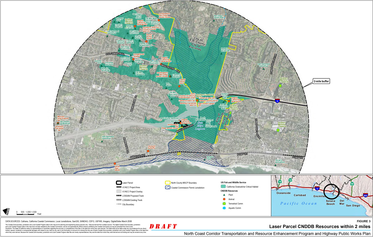
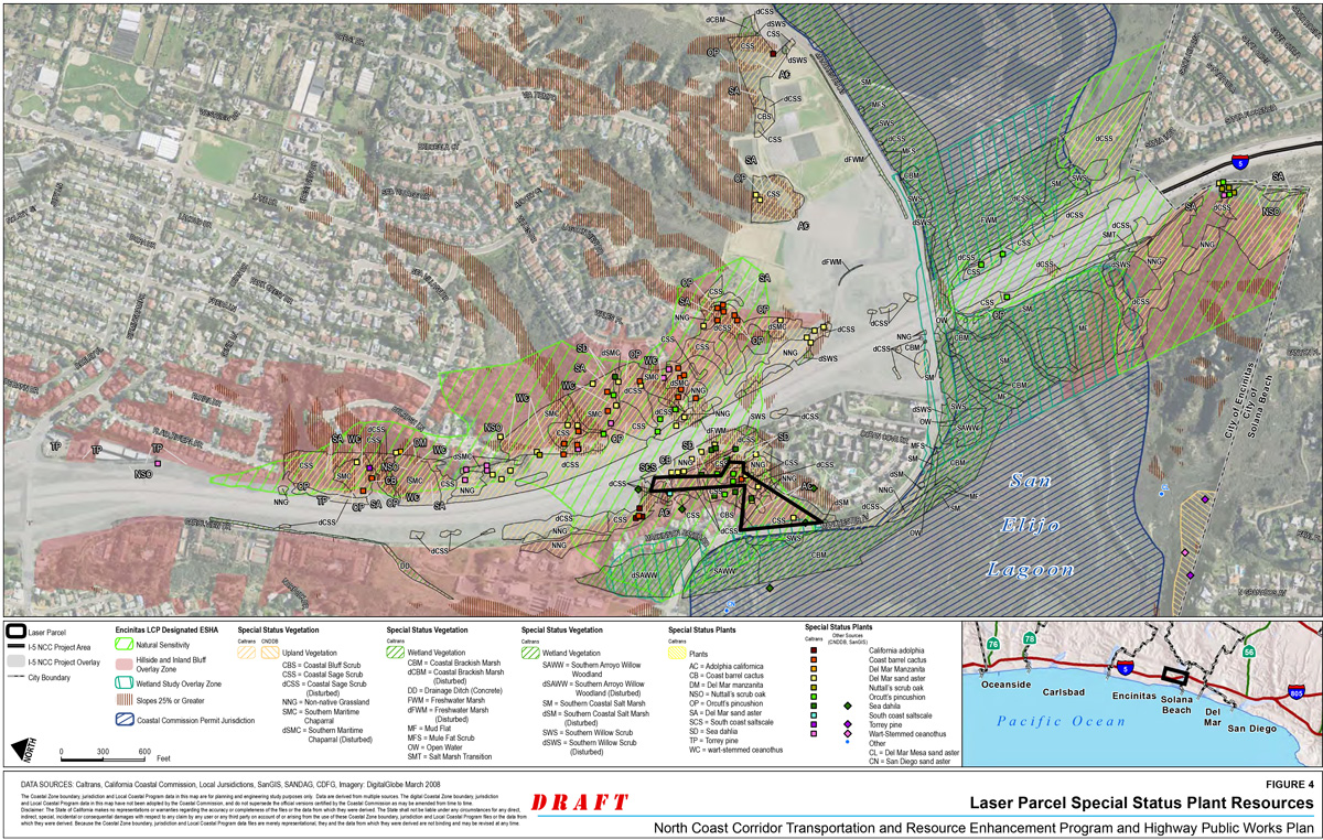
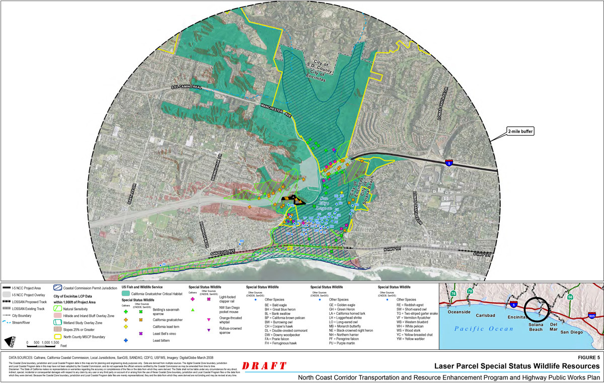

San Elijo Lagoon
- Site Location: San Elijo Lagoon is located in the City of Encinitas just north of Solana Beach. The lagoon is part of the larger San Elijo Lagoon Ecological Reserve that includes approximately 1,000 acres of wetland and upland habitat.
- Latitude/Longitude: 33.007931/-117.272033
- Ownership: State of California (CDFG), the County of San Diego, and the San Elijo Lagoon Conservancy (SELC). The reserve is mainly operated by the County of San Diego, however, CDFG and the San Elijo Nature Conservancy Center are also involved in operations.
- Correspondence with Resource Agencies: Stakeholders, including the Army Corps of Engineers (USACE), County of San Diego, SELC, San Diego Association of Governments (SANDAG), California Department of Transportation (Caltrans), and other state resource agencies are currently coordinating efforts to prepare a Draft EIR/EIS for the San Elijo Lagoon Restoration Project.
Mitigation Goal
SANDAG and Caltrans propose to mitigate impacts to USACE jurisdictional and State wetlands, as well as sensitive upland habitats associated with the North Coast Corridor Public Works Plan/Transportation and Resource Enhancement Program (PWP/TREP) by funding the restoration of San Elijo Lagoon. The San Elijo Lagoon Restoration Project (SELRP) includes restoring the hydrological regime and the marsh habitat and converting middle and high marsh habitat to mudflats and low marsh habitat within San Elijo Lagoon. Restoration alternatives under consideration include the following: 1) potential opening of the lagoon mouth and/or relocating the lagoon inlet at Coast Highway, 2) lengthening the I-5 bridge across San Elijo Lagoon to create wetland habitat within the existing bridge footprint and facilitate the restoration of marsh habitat through the improved hydrology, 3) dredging of channels and marsh habitat to create more mudflat and low marsh habitats, and 4) provide endowments for future lagoon maintenance.
The proposed SELRP will provide the following benefits (SELC 2012):
- Enlarge the tidal prism to increase the area of tidal expansion within the lagoon.
- Improve water quality through restored tidal circulation, thereby reducing impacts to the public from beach closures due to high bacteria counts and the potential for mosquito-borne disease.
- Ensure no adverse change to current flood protection, specifically to existing infrastructure and adjacent development.
- Provide a natural gradient of habitats that consider climate change, anticipated sea level rise, heterogeneity of habitats, and tidal channels of various orders.
- Enhance habitats for native species, including rare and endangered species.
The provision of endowment funds for future lagoon maintenance will provide the following management benefits:
- Cost-effective management and maintenance plan for supporting the proposed habitat enhancements, curtailing growth and expansion of exotic species, and maintaining regular tidal flow.
- Design and implement a biological and hydrological monitoring program to assess the success of restoration efforts and facilitate adaptive management decisions.
- Maintain lagoon public access and educational opportunities consistent with resource protection needs and requirements.
San Elijo Lagoon
The San Elijo Lagoon consists of approximately 491 acres. The lagoon watershed encompasses all drainages that convey water into San Elijo Lagoon including Escondido Creek, San Elijo Creek, and their tributaries.
Existing Conditions
San Elijo Lagoon Ecological Reserve is transitioning from open water and mudflat habitats to salt marsh and riparian habitat as a result of urban pressures. Transportation infrastructure contributes to restricted tidal flushing and degraded water quality in the reserve. As the population expands in Southern California, the ecology of the wetland will continue to be impacted by both historical and future development. The future restoration project would thus restore the lagoon, a biodiversity hot spot and one of the few remaining wetland systems in Southern California to a more natural state.
Ecological Context
Habitats present in or within the vicinity of San Elijo Lagoon primarily include open water (estuarine and fresh), sand/mudflats, coastal salt marsh, fresh/brackish marsh, riparian, and Diegan coastal sage scrub upland. San Elijo Lagoon and its upland habitats support a number of special-status wildlife species including California least tern (Sterna antillarum browni), Belding's savannah sparrow (Passerculus sandwichensis beldingi), California gnatcatcher (Polioptila californica californica), and light-footed clapper rail (Rallus longirostris levipes). The lagoon is part of the SELC and its maintenance is coordinated by the SELC.
Drainage and Hydrology
San Elijo Lagoon is associated with the Carlsbad Hydrologic Unit (HU). The Carlsbad HU is comprised of seven sub-basins that include San Elijo Lagoon (Escondido Creek), Cottonwood Creek, Batiquitos Lagoon (San Marcos Creek), Encinas Creek, Agua Hedionda Lagoon (Agua Hedionda Creek), Buena Vista Lagoon (Buena Vista Creek), and Loma Alta Creek. The freeway and rail bisect four lagoons in this HU: San Elijo Lagoon, Batiquitos Lagoon, Agua Hedionda Lagoon, and Buena Vista Lagoon. All four of the lagoon crossings, including Loma Alta Creek, are on bridge structures. Development within the Carlsbad HU is projected to increase from 56% to 70% by the year 2015.
Beneficial uses within San Elijo Lagoon include contact recreation such as hiking, non-contact recreation such as wildlife viewing and nature tours, biological habitats of special significance, estuarine habitat, wildlife habitat, marine habitat, rare/threatened/endangered species habitat, migration corridors, and spawning/reproduction and/or early development habitat.
Soils
Upland and bank soils within the proposed mitigation areas are associated with marine terraces. The typical soils in the potential restoration areas include tidal flats; Corralitos loamy sand, 5 to 9 percent; Corralitos loamy sand, 9 to 15 percent; marina loamy coarse sand, 2 to 9 percent slopes; and terrace escarpments (NRCS 2012, soil survey maps).
Vegetation
The San Elijo Lagoon vegetated areas are composed primarily of sand/mudflats, coastal salt marsh, fresh/brackish marsh, southern riparian scrub, and coastal sage scrub vegetation community types.
Wildlife
San Elijo Lagoon and its upland habitats support special-status wildlife species such as California least tern, Belding's savannah sparrow, California gnatcatcher, and light-footed clapper rail. San Elijo Lagoon also provides important foraging and resting habitat for waterfowl and shorebirds along the Pacific flyway.
Mitigation Program
The mitigation program for SELRP aims to provide comprehensive lagoon restoration through a suite of possible restoration alternatives, which may include infrastructure improvements where the facilities cross the Lagoon, hydrological improvements to the Lagoon mouth opening, and, where determined appropriate, through providing endowments for Lagoon planning, restoration, and maintenance in the future. These efforts would not only serve to substantially enhance and restore water quality in the corridor, but they would also serve to restore, enhance, and protect different habitat types within the Lagoon ecosystem.
Schedule
Detailed design of the mitigation program will begin upon selection of a preferred alternative by the resource agencies, and completion of environmental review. Currently, the City of Encinitas, USACE, USFWS, CDFG, County of San Diego, and the SELC is working to complete a Draft EIR/EIS for the restoration of the lagoon. SANDAG/Caltrans has participated with the City of Encinitas, USACE, Coastal Commission, and other resource agencies in the feasibility analyses and modeling studies to determine optimal bridge openings at all major transportation crossings across the Lagoon for facilitating the mitigation program.
This REP mitigation opportunity includes funding large-scale lagoon restoration program at San Elijo Lagoon, in addition to funds already contributed to previous and ongoing planning and technical evaluation activities necessary to facilitate and implement this Lagoon restoration program. REP measures that contribute to large-scale Lagoon restoration opportunities (funding, critical transportation infrastructure improvements) shall be considered a substantial mitigation element for all PWP/TREP project impacts (including temporary impacts) given the resulting wide range of benefits to sensitive habitat for plant and wildlife species, water quality, flood control, groundwater recharge, and recreation. For purposes of the PWP/TREP, a detailed design of the selected alternative will be provided through the subsequent Coastal Development Permit and federal consistency review processes. The results of the consultations with persons and agencies interested in, with jurisdiction over, and/or affected by the proposed development, including consultations with federal and state resource agencies (e.g., USACE, U.S. Fish and Wildlife Service [USFWS], CDFG, Regional Water Quality Control Board [RWQCB], etc.), as well as all supporting documentation would be submitted with the Coastal Development Permit application.
Mitigation Goal and Purpose
The mitigation program will aim to preserve, protect and enhance the San Elijo Lagoon Ecological Reserve and, in turn, it's watershed. The mitigation program would result in the restoration and enhancement of an integrated ecosystem, providing improved habitat for fish, birds, and benthic organisms that would adequately compensate for the loss of wetland habitat occurring from the PWP/TREP rail and highway improvements. This large regional restoration project could ultimately facilitate the restoration of many hectares of wetlands, which would help to ensure the Lagoon's continued health and greatly enhance the coastal lagoon habitat.
To achieve the goals of the mitigation program, the EIR/EIS process, technical studies, and design work are currently being conducted to evaluate alternative actions to restore the habitat functions and services of the Lagoon. These studies and environmental review processes are being been used to evaluate the restoration opportunities available within the San Elijo Lagoon and will be used in the ultimate design of the proposed mitigation program.
Alternatives
Three build alternatives are being studied for the SELRP EIR/EIS, which are described below in greater detail.
Alternative 1A
Alternative 1A provides minimal physical changes to the site, with the exception of enlarging the main feeder channel throughout the site and redirecting its course just west of I-5. The main tidal channel is also extended farther into the East Basin and existing constricted channel connections are cleared and enlarged. Existing habitat areas will essentially remain intact. The tidal prism of Alternative 1A will slightly increase compared to existing conditions. A relatively small area of transitional habitat above tidal elevations will be placed in the northwest portion of the Central Basin.
Alternative 1B
Alternative 1B provides a more substantial change to the existing site to create a greater diversity of habitats than currently exists. The existing tidal inlet remains the source of seawater, and the main tidal channel extends throughout the Lagoon. A new subtidal basin off the main channel is created in the Central Basin. The main feeder channel is redirected just west of I-5 and extended farther into the East Basin. The channel in the East Basin is significantly enlarged in the cross-sectional area to promote more tidal exchange east of I-5. The tidal prism of Alternative 1B will be significantly increased compared to Alternative 1A. Non-tidal habitat areas will still exist in the East Basin. Several areas of transitional habitat above tidal elevations will be placed in the western portion of the Central Basin.
Alternative 2A
Alternative 2A also provides changes to the existing site to create a greater diversity of habitats than presently exists. Seawater would enter the Lagoon via a new tidal inlet located south of the existing inlet and a new subtidal basin would be created just landward of the new inlet in the West and Central Basins. A new railroad bridge would be built adjacent to the new inlet to provide a more direct connection to the rest of the lagoon. The main tidal channel would extend throughout the Lagoon and be redirected just west of I-5, and extend into the East Basin. The channel in the East Basin is identical to that for Alternative 1B. The tidal prism of Alternative 2A will increase compared to Alternative 1B. Non-tidal habitat areas remain in the East Basin. Transitional habitat areas above tidal elevations will also be included in the Central Basin.
Hydrology
San Elijo Lagoon sustains a significant opportunity for hydrodynamic restoration. Restoring the hydrodynamics of the Lagoon, a vital coastal resource in the region, would provide a mechanism for conveyance and dissipation of floodwater, allow for deposition of flood-suspended sediments, assist with shoreline stabilization, and facilitate the recharge of groundwater and storage of surface waters. Improvements to the hydrology of San Elijo Lagoon would also serve to improve the filtration of suspended sediments and toxic substances and facilitate nutrient cycling, denitrification, and mineralization.
The San Elijo Lagoon Restoration Project that is currently underway is evaluating infrastructure factors that affect tidal circulation including the lagoon inlet, bridges for South Coast Highway 101, rail and highway facilities, and the existing tidal regime within the lagoon. Based on analysis conducted for the San Elijo Lagoon Restoration Project and the I-5 project, the I-5 bridge will be lengthened, thereby creating wetland habitat within the existing bridge footprint and facilitating the restoration of marsh habitat through improved hydraulic flows. Lengthening the I-5 bridge would ultimately enhance all lagoon functions and decrease tidal muting effects in the eastern basin. Other key findings from the optimization modeling study for all potential alternatives are summarized as follows:
- For alternatives that rely on the existing inlet channel (No Project, Alternative 1A, and Alternative 1B), the existing Hwy 101 Bridge structure and the Railroad Bridge structure have sufficient spans and are not limiting factors for tidal range or flood conveyance. The limiting factor for these alternatives is the long and narrow inlet channel between Hwy 101 and the Railroad Bridge. The main channel through the Central Basin is also narrow, shallow, and sinuous resulting in additional energy losses during normal tidal fluctuations and extreme flood events.
- There is no benefit to tidal flows and storm flow conveyance from increasing the existing I-5 Bridge channel dimension for No Project and Alternative 1A conditions. Regardless of the I-5 Bridge channel dimension, Manchester Avenue will experience flooding in the East Basin during a 100-year event. The existing I-5 Bridge channel dimension helps prevent additional flooding of Manchester Avenue in the Central Basin by attenuating peak flows in the East Basin. This attenuation results in higher flood levels in the East Basin, but little or no flooding in the Central Basin. If the I-5 Bridge channel is widened, flood elevations are lowered in the East Basin, but raised in the Central Basin causing flooding of Manchester Avenue in both basins.
- Bridge optimization modeling of Alternative 1B suggested that increasing the I-5 Bridge channel width to 261 feet would relieve some flooding of Manchester Avenue in the East Basin. Portions of the roadway will still experience flooding, however, an increased bridge channel width would reduce flood levels below a significant length of roadway in the East Basin.
- For Alternative 2A, the optimization modeling study supported the recommended bridge channel dimensions identified in the SELRP Feasibility Studies. A Hwy 101 inlet channel width of 200 feet, a railroad channel width of 590 feet and an I-5 channel width of 261 feet were found to provide optimum tidal range and flood conveyance.
Performance Criteria
The California Rapid Assessment Method (CRAM), a performance criteria metric, has already been completed for the lagoon and will be used as a functional assessment to determine success in achieving the mitigation program goals. All the goals will be developed for the SELRP EIR/EIS and the HMMP (habitat mitigation and monitoring plan) documents. Interim target functional criteria scores will be used to inform maintenance decisions during the long-term monitoring and maintenance period to achieve the final target functional criteria assessment scores.
Site Protection
The San Elijo Lagoon is part of the San Elijo Lagoon Ecological Reserve. Areas that will be restored will remain part of the San Elijo Lagoon Ecological Reserve once the mitigation in those areas is in place and complete.
Additional Studies
Stakeholders, including the SELC, SANDAG, and Caltrans are currently coordinating efforts to prepare a Draft EIR/EIS for the SELRP. Additional studies necessary for the design and implementation of the proposed mitigation project in San Elijo Lagoon will be evaluated once the environmental and preliminary planning processes are complete.
Required Permits
404, 401, 1602, ESA/CESA Permits, and a Coastal Development Permit would likely be required for the proposed mitigation efforts in San Elijo Lagoon.
References
- SELC 2012. San Elijo Lagoon Restoration Project website, accessed August 15, 2012.
- Moffatt & Nichol 2012. San Elijo Lagoon Bridge Optimization Study Final Report. April.
Buena Vista Lagoon
- Site Location: Buena Vista Lagoon is located in the cities of Carlsbad and Oceanside.
- Latitude/Longitude: 33.173972/ -117.349208
- Ownership: California Department of Fish and Game (CDFG), cities of Carlsbad and Oceanside, Buena Vista Lagoon Foundation, North County Transit District (NCTD), the California Department of Transportation (Caltrans), and private developments.
- Correspondence with Resource Agencies: Stakeholders, including the Buena Vista Lagoon Foundation, San Diego Association of Governments (SANDAG), and Caltrans, are currently working on the EIR/EIS for the Buena Vista Lagoon restoration.
Mitigation Goal
SANDAG and Caltrans propose to mitigate impacts to U.S. Army Corps of Engineers (USACE) jurisdictional and State wetlands, as well as sensitive upland habitats associated with the North Coast Corridor Public Works Plan/Transportation and Resource Enhancement Program (PWP/TREP) by restoring the hydrological regime and the wetland habitat within Buena Vista Lagoon. Restoration alternatives presently under consideration include the following common components:
- opening the lagoon inlet at the terminus of the watershed and adjacent to the Pacific Ocean, allowing passive restoration to a fresh water1 or a saltwater system;
- modify rail and highway bridge designs over the Buena Vista Lagoon, offsetting wetland fill impacts with the establishment of new wetland areas and improved flushing and streamflow;
- restoring tidal/fluvial hydrology and maintaining hydrologic conditions through dredging;
- improving flows through construction improvements to Coast Highway by opening up basins that have historically been separated, and
- providing endowments for future lagoon maintenance and planning.
Existing Conditions
Ecological Context
Buena Vista Lagoon area consists of approximately 203 acres. The lagoon watershed encompasses all drainages that convey water into Buena Vista Lagoon including Buena Vista Creek and its tributaries. Habitats present in or within the vicinity of Buena Vista Lagoon primarily include open water (estuarine and fresh), coastal brackish and freshwater marsh, southern riparian scrub, and Eucalyptus woodland. In addition, Buena Vista Lagoon and its wetland and upland habitats support a number of special-status wildlife species including California gnatcatcher (Polioptila californica californica), Belding's savannah sparrow (Passerculus sandwichensis beldingi), and light-footed clapper rail (Rallus longirostris levipes).
The lagoon is part of the Buena Vista Lagoon Ecological Reserve that is maintained by CDFG. Buena Vista Lagoon is currently a freshwater lagoon that, for the most part, is not connected to the ocean except through a non-adjustable weir.
Drainage and Hydrology
Buena Vista Lagoon is associated with the Carlsbad Hydrologic Unit (HU) watershed that drains Buena Vista Creek. The Carlsbad HU is comprised of seven sub-basins that include San Elijo Lagoon (Escondido Creek), Cottonwood Creek, Batiquitos Lagoon (San Marcos Creek), Encinas Creek, Agua Hedionda Lagoon (Agua Hedionda Creek), Buena Vista Lagoon (Buena Vista Creek), and Loma Alta Creek. The freeway and railway bisect four lagoons in this HU: San Elijo Lagoon, Batiquitos Lagoon, Agua Hedionda Lagoon, and Buena Vista Lagoon. All four of the lagoon crossings, including Loma Alta Creek, are on bridge structures. Development within the Carlsbad HU is projected to increase from 56% to 70% by the year 2015.
Beneficial uses within Buena Vista Lagoon include the following: contact recreation such as fishing and hiking, non-contact recreation such as wildlife viewing and nature tours, biological habitats of special significance, estuarine habitat, wildlife habitat, marine habitat, and warm freshwater habitat.
Three existing transportation corridors cross the Lagoon (I-5, LOSSAN rail, and Coast Highway/Carlsbad Boulevard), which segments the Lagoon into four basins (Everest 2004). The ocean connection through a non-adjustable weir and LOSSAN rail-bound the Weir Basin. The Railroad Basin is situated between the LOSSAN rail and Coast Highway. The Coast Highway Basin is located between Coast Highway and I-5. The I-5 Basin is located between I-5 and the mouth of Buena Vista Creek as it enters the Lagoon. The existing culvert under Coast Highway/Carlsbad Boulevard is inadequate to accommodate storm flows from moderate storm events, thereby limiting hydrologic exchange between the Coast Highway Basin and Railroad Basin. Sedimentation and vegetation in the vicinity of the crossings restrict flows between the four basins.
Soils
Upland soils in potential mitigation areas, located west of the potential I-5 area of effect, are largely associated with marine terraces. The typical soils in the potential restoration areas include marina loamy coarse sand, 2 to 9 percent slopes; terrace escarpments; and Tujunga sand, 0 to 5 percent slopes (NRCS 2012, soil survey maps). Due to adjacent urban land use, most soils along the banks of the potential mitigation area are imported soils of sand to sandy loam.
Habitat and Vegetation Communities
Habitat and vegetation communities within Buena Vista Lagoon are comprised primarily of coastal brackish and freshwater marsh, southern riparian scrub, and Eucalyptus woodland. Open water habitat is the primary habitat type and found in all four basins.
The Lagoon is highly disturbed being surrounded by development and a non-adjustable weir at the Pacific Ocean outlet.
Wildlife
Bird and waterfowl nesting islands were created in the lagoon in 1983. The lagoon provides important habitat supporting special-status wildlife species such as Belding's savannah sparrow, California gnatcatcher, and light-footed clapper rail. Many species of waterfowl also use the lagoon for foraging and resting along the Pacific flyway.
Existing Utilities/Infrastructure/Easements
There are several utilities (e.g., gas lines, electric lines, communication lines, water pipes, storm drains, and sewer lines) on or near the Lagoon. The functional performance of these infrastructure components must be maintained, mitigated, or replaced as part of the restoration project. In addition, there are some existing easements and agreements between various agencies and utility companies that might pose constraints to restoration, enhancement, and the establishment of wetlands within the Lagoon.
Mitigation Program
The mitigation program for the Buena Vista Lagoon, currently under development as part of the Buena Vista Lagoon Restoration Project planning process, aims to provide comprehensive lagoon restoration efforts through a suite of potential mitigation opportunities. The mitigation opportunities include opening the lagoon inlet at the terminus of the watershed and adjacent to the Pacific Ocean, modifying rail and highway bridge designs over the Buena Vista Lagoon, restoring tidal/fluvial hydrology and maintaining hydrologic conditions through dredging, improving flows through construction improvements to Coast Highway by opening up basins that have historically been separated, providing endowments for future lagoon maintenance and planning.
Numerous agencies and organizations have been working toward restoring the lagoon, including, but not limited to, the California Coastal Conservancy, U.S. Fish and Wildlife Service (USFWS), Regional Water Quality Control Board (RWQCB), National Oceanic and Atmospheric Administration (NOAA), U.S. Army Corps of Engineers (USACE), the cities of Carlsbad and Oceanside, the Buena Vista Lagoon Foundation, The California Coastal Commission (CCC), and other local permitting agencies. The first phase of restoration planning, consisting of several studies assessing the feasibility of restoring function and habitat values by modifying the lagoon's hydrology was completed in 2010.
"Phase II" restoration planning is currently underway and consists of the preparation of preliminary engineering and environmental documents requiring further development and evaluation of restoration alternatives for the lagoon. SANDAG/Caltrans has participated with the resource agencies as part of the NEPA 404 process for the I-5 project to determine the optimal bridge openings at all major transportation crossings to help facilitate (and not preclude) any future restoration plans for the lagoon.
Schedule
The Buena Vista Lagoon Foundation and its partners have completed a strategic plan and a restoration feasibility analysis that identifies proposed potential hydraulic regimes—saltwater, freshwater, or mixed water—and project alternatives. Restoration alternatives are being further examined as part of an ongoing lagoon restoration project EIR/EIS. Completion of this document is expected in 2013 with final engineering, permitting, and construction to follow as funding allows.
This REP mitigation opportunity includes funding large-scale lagoon restoration at Buena Vista Lagoon, in addition to funds already contributed to previous and ongoing planning and technical evaluation activities necessary to facilitate and implement this lagoon restoration program. REP measures that contribute to large-scale lagoon restoration opportunities (funding, critical transportation infrastructure improvements) shall be considered a substantial mitigation element for all PWP/TREP project impacts (including temporary impacts) given the resulting wide range of benefits to sensitive habitats for plant and wildlife species, water quality, flood control, groundwater recharge, and recreation. For purposes of the PWP/TREP, the detailed design of the Buena Vista Lagoon restoration/enhancement projects will begin upon selection of a preferred alternative by the resource agencies and be provided through subsequent Coastal Development Permit and federal consistency review processes. The results of the consultations with persons and agencies interested in, with jurisdiction over, and/or affected by the proposed development, including consultations with federal and state resource agencies (e.g., USACE, U.S. Fish and Wildlife Service [USFWS], CDFG, Regional Water Quality Control Board [RWQCB], etc.), as well as all supporting documentation would be submitted along with the Coastal Development Permit application.
Mitigation Goal and Purpose
The Buena Vista Lagoon Restoration Project seeks to preserve, protect and enhance the Buena Vista Lagoon Ecological Reserve. The Buena Vista Lagoon mitigation program would provide an opportunity to modify rail and highway bridge designs over the Buena Vista Lagoon, which could ultimately have a beneficial effect on water quality and marine resources by offsetting wetland fill impacts with the establishment of new wetland areas and providing for improved flushing and streamflow where feasible. Restoring hydrodynamic conditions in Buena Vista Lagoon would significantly improve water quality and the ecological value of the lagoon, riparian system, and adjacent upland areas to better support environmentally sensitive habitat areas (ESHAs), special-status species, and wildlife.
The two saltwater and two freshwater alternatives, discussed below, have been determined to be the most viable restoration opportunities, as discussed in the I-5/SR78 Interchange Preliminary Engineering I-5 Bridge Study at Buena Vista Lagoon draft report (Everest 2012).
Alternatives
A number of restoration alternatives were developed over the past few years under the direction of several federal and state agencies including, the California State Coastal Conservancy (SCC), U.S. Fish and Wildlife Service (USFWS), and CDFG. Four of these alternatives were selected for further study because the proposed grading and outlet/inlet configurations represent a reasonable range of potential restoration conditions for Buena Vista Lagoon. These alternatives were analyzed to evaluate the ranges of dimensions for the hydraulic connections to provide design guidance for the bridge structures under consideration by Caltrans. These four alternatives are listed below and described in the following sections.
- Saltwater Alternative: Alt 2-1
- Saltwater Alternative: Alt SW2-A
- Freshwater Alternative: Alt 1
- Freshwater Alternative: Alt FW-A
Salt Water Alternatives
Alt 2-1
Alternative 2-1 represents the restoration configuration of a saltwater hydrologic regime developed for the restoration project in 2008. This alternative achieved the restoration objectives primarily through the elimination of the existing exotic vegetation, dredging to remove excess sediment and establishment of continuous tidal exchange. The existing weir would be replaced with a tidal inlet to provide a continuous tidal exchange between the Lagoon and the Pacific Ocean. The tidal inlet would require stabilization with two jetties that would extend to the Mean Lower Low Water (MLLW) contour. The bottom elevation of the Railroad Basin and Weir Basin would be dredged to between -12 ft and -15 ft, NGVD to provide a sediment trap for sand entering the lagoon from the ocean. Prominent features of this alternative were described in the 2008 Hydraulic Study Report (Everest 2008).
Alt SW2-A
Alternative SW2-A is the latest saltwater restoration alternative developed for the Lagoon. In this alternative, a channel would run along the center of the I-5 Basin and Coast Highway Basin at -3.3 ft, NGVD, with the two banks of the channel being graded with a slope not greater than 1:8 (vertical: horizontal). Downstream of the railroad bridge, the channel would widen and form a basin with a uniform depth of -3.3 ft NGVD at the Railroad Basin and Weir Basin. The tidal inlet channel would be constructed with an initial bottom elevation of -2.0' NGVD and no jetties would be constructed to stabilize the inlet channel. Prominent features of this alternative were described in the 2011 technical memo (Everest 2011a).
Fresh Water Alternatives
Alt 1
Alternative 1 represents the restoration configuration that was used to analyze the freshwater hydrologic regime as part of the Buena Vista Lagoon Restoration Project Feasibility Study in 2004. This alternative would achieve the restoration objectives primarily through the elimination of the existing exotic vegetation and dredging to remove excess sediment. It was assumed that the existing ocean outlet weir would be replaced with an 80-foot (ft) wide ocean outlet weir in accordance with the weir widening project that was proposed by the City of Oceanside. The invert elevation of the weir would be kept at the invert elevation of the existing weir, which is 5.6 ft, NGVD. The bottom elevation of the Railroad Basin and Weir Basin would be dredged to between -12 ft and -15 ft, NGVD. Prominent features of this alternative were described in the
2008 fluvial hydraulics report (Everest 2008). It should be noted that for the sea level rise analysis presented in this report, it was assumed that the invert elevation of the weir would be raised by the projected value of sea-level rise (55 inches) in order to keep ocean water from entering the Lagoon. This assumption was necessary to preserve the freshwater condition of the Lagoon under this freshwater alternative.
Alt FW-A
Alternative FW-A is the latest freshwater alternative developed for the Lagoon. The central portions of each basin would be dredged to maintain a water depth of about six feet (bottom elevation of about 0 ft), NGVD) to minimize the future encroachment of cattails throughout the Lagoon. Similar to Alt 1, it was assumed that the existing ocean outlet weir would be replaced with an 80-ft wide ocean outlet weir in accordance with the weir widening project that was proposed by the City of Oceanside. The invert elevation of the weir would be kept at the invert elevation of the existing weir, which is 5.6 ft, NGVD. Prominent features of this alternative were described in the 2011 technical memo (Everest 2011a). It should be noted that for the sea level rise analysis presented in this report, it was assumed that the invert elevation of the weir would be raised by the projected value of sea-level rise (55 inches) to keep ocean water from entering the Lagoon. This assumption was necessary in order to preserve the freshwater condition of the Lagoon under this freshwater alternative.
Hydrology
A fluvial hydraulics analysis was conducted to provide guidance for the three bridge/culvert structures (Interstate 5 Bridge, Coast Highway Culvert/Bridge, and Railroad Bridge) located within the Buena Vista Lagoon. The purpose of the analysis was to establish the minimum channel width and minimum channel depth that would need to be accommodated by the three bridge/culvert structures such that future implementation of saltwater or freshwater restoration alternative will not be restricted by the existing and future bridges/culverts.
The HEC-RAS one-dimensional fluvial hydraulics model developed by the U.S. Army Corps of Engineers (USACE 2006) was used to conduct the fluvial hydraulics analysis in the present study. HEC-RAS is capable of simulating unsteady flow through a network of open channels and can account for hydraulic structures such as bridges, culverts, and weirs. The model is approved by the Federal Emergency Management Agency (FEMA) for flood studies and is commonly used by the USACE and Caltrans for fluvial hydraulics analyses.
The fluvial hydraulics analysis was conducted under the current mean sea level and the projected mean sea level in the Year 2100 based on the current guidance provided by the California Ocean Protection Council (COCP 2011). Based on the results of the analysis, the conclusions presented below were drawn for each of the three bridge channels.
- The channel under the existing Interstate 5 Bridge is not sufficient to accommodate a near full tide range nor is it sufficient to convey the fluvial flows analyzed in this study. The new Interstate 5 Bridge should be designed to accommodate a channel with a bottom width of 105 feet (at -6 ft, NGVD) and top width of 180 ft (at 14 ft, NGVD). The soffit of the existing Interstate 5 Bridge (23.1 ft, NGVD) is almost ten feet above the predicted flood water elevation for a 100-year flood event occurring with the projected mean sea level for the Year 2100.
- The channel under the existing Coast Highway Culvert/Bridge is not sufficient to accommodate a near full tide range nor is it sufficient to convey the fluvial flows analyzed in this study. The new Coast Highway Culvert/Bridge should be designed to accommodate a vertically-walled channel with a width of 110 feet and bottom elevation of -6 ft, NGVD. The soffit of the existing Coast Highway Culvert/Bridge (8.2 ft, NGVD) is about 1.5 feet (saltwater alternative) to 5.5 feet (freshwater alternative) below the predicted flood water elevation for a 100-year flood event occurring with the projected mean sea level for the Year 2100 thereby indicating that flooding of the structure would occur. This should be taken into account during the design of the new Coast Highway Culvert/Bridge.
- The channel under the existing Railroad Bridge is not sufficient to accommodate a near full tide range nor is it sufficient to convey the fluvial flows analyzed in this study. The width of the channel under the existing Railroad Bridge would be adequate to accommodate the fluvial flows analyzed in this study; however, the bottom elevation would need to be deepened from –2.5 ft, NGVD to -4 ft, NGVD. To accommodate a near full tide range the bridge would need to accommodate a channel with a bottom elevation of -6 ft, NGVD. If the existing bridge structure and foundation are capable of accommodating this increase in channel depth and the forces from higher flood levels, then the existing structural configuration would not need to be changed and would still convey the fluvial flows analyzed in this study and accommodate the implementation of a near full tidal saltwater restoration project in the future (Everest 2008). This should be taken into account during the design of a new Railroad Bridge when such work is undertaken. The soffit of the existing Railroad Bridge (11.1 ft, NGVD) is about 2.5 feet below the predicted flood water elevation for a 100-year flood event occurring with the projected mean sea level for the Year 2100; therefore, flooding of that structure would occur under the fluvial flows analyzed in this study. This should be taken into account during the design of a new Railroad Bridge when such work is undertaken.
- The results of the fluvial modeling indicated that improvements to the Interstate 5 Bridge and Coast Highway Culvert/Bridge would result in higher flood levels within the Coast Highway Basin and Weir Basin because the flood flow is conveyed more efficiently to these lower basins from the Interstate 5 Basin. While representing an improvement in the overall flood hydraulics, an increase in flood levels within these two basins under the two freshwater alternatives could result in impacts to private property and infrastructure, especially in the Weir Basin where the St. Malo community is located. Everest (Everest 2004 and 2008) reported a similar finding for existing conditions, which is a freshwater system controlled by the 50 ft wide weir. The proposed freshwater alternatives feature an 80 ft wide weir which does help to alleviate the problem compared to the existing 50 ft wide weir; however, the 80 ft weir is still not large enough to convey increased rate of flow resulting from the improvements in the Interstate 5 Bridge and Coast Highway Culvert/Bridge. Consequently, this issue should be addressed as part of the implementation process associated with the I-5 North Coast Corridor (NCC) Project and any future work associated with the Coast Highway Culvert/Bridge. It is envisioned that this would include further analysis to determine if flooding of property and infrastructure would occur as well as the development of mitigation measures to reduce such flooding to levels of insignificance. For example, the weir could be widened to convey the increased rate of flow resulting from the improvements in the Interstate 5 Bridge and Coast Highway Culvert/Bridge. Alternatively, the berm surrounding the St. Malo community could be raised to reduce the risk to property from any increased flooding.
Topographic Modification
Additional topographic and hydrologic studies will need to occur following the selection of a preferred restoration alternative to determine if and to what extent grading will be required to facilitate the proposed restoration activities.
Soils
Soil testing would be completed during the design process to determine what soils and groundwater levels are expected onsite to help in designing restoration activities. Any soil deficiencies or issues will be examined to ensure that plans take into account soils found onsite.
Performance Criteria
Performance criteria will be developed in the restoration plan and included in the EIR/EIS for the Lagoon restoration.
Site Protection
The Lagoon is part of the Buena Vista Ecological Reserve. Areas that will be restored will remain part of the Buena Vista Ecological Reserve once the mitigation in those areas is in place and complete.
Long Term Management
A Habitat Management Plan (HMP) will be prepared to define the long term management responsibilities to maintain the biological resources that are established through the mitigation project. CDFG will assume long term management responsibilities in association with existing areas within the Buena Vista Ecological Reserve. Additionally, funds for long term management may be provided by SANDAG/Caltrans and placed into a non-wasting endowment. Any potential endowment funds will be established using a Property Assessment Report that is based on the approved HMP.
Additional Studies
Further studies will be required to determine the extent and detail of the proposed restoration projects and will be conducted through the EIR/EIS process. These studies include a tidal hydrology study to establish target grade elevations that will create appropriate tidal inundations to support and sustain salt marsh habitat. Soil testing will need to occur to determine the appropriateness of existing soils for revegetation efforts. A topographic survey will be required to support construction grading design and construction plans. In addition, deed-restricted, easement, and fuel/fire zone areas will also need to be quantified to determine boundaries and acreages that can be counted toward mitigation credit. The location of culverts, stormwater outfalls, or low areas where runoff from adjacent communities will also need to be mapped and analyzed to determine how flows onsite may affect restoration efforts. Field surveys will also need to occur to determine more accurately where and what type of mitigation opportunities exist.
Required Permits
404, 401, 1602, and a Coastal Development Permit would likely be required for the proposed mitigation efforts in Buena Vista Lagoon.
References
- COPC (California Ocean Protection Council). 2011. Resolution of the California Ocean Protection Council on Sea-Level Rise, Adopted on March 11, 2011.
- Everest. 2004. Buena Vista Lagoon Restoration Feasibility Analysis Final Report. Prepared for Buena Vista Lagoon Foundation, California State Coastal Conservancy, U.S. Fish and Wildlife Service. Prepared by Everest International Consultants, Inc. June 2004.
- Everest. 2008. Buena Vista Lagoon Restoration Project Fluvial Hydraulics, Sediment Transport, and Sedimentation Analysis Final Report. Prepared for California State Coastal Conversancy. Prepared by Everest International Consultants, Inc. under contract to Science Applications International Corporation. October 2008.
- Everest. 2011a. Buena Vista Lagoon Restoration Project – Restoration Alternatives, Draft Technical Memorandum. Prepared for California Department of Fish and Game. Prepared by Everest International Consultants, Inc. December 2011.
- Everest. 2012. I-5/SR78 Interchange Preliminary Engineering I-5 Bridge Study at Buena Vista Lagoon Fluvial Hydraulics and Residence Time Analysis Draft Report. Prepared for The State of California, Department of Transportation. Prepared by Everest International Consultants, Inc. January 2012.
- NRCS. 2012. Natural Resources Conservation Service. Soil Survey Staff, United States Department of Agriculture. Web Soil Survey. Available online at http://websoilsurvey.nrcs.usda.gov/. Accessed August 15, 2012.
- USACE. 2006. HEC-RAS River Analysis System User's Manual Version 4.0 Beta. U.S. Army Corps of Engineers Hydrologic Engineering Center. November 2006.