Appendix A – Implementation
1.0 The North Coast Corridor Vision
The Interstate 5 (I-5) North Coast Corridor (NCC) Public Works Plan / Transportation and Resource Enhancement Program (PWP/TREP) provides the California Department of Transportation (Caltrans) and the San Diego Association of Governments (SANDAG) with a ground-breaking programmatic approach for implementing the region's multimodal transportation and resource enhancement vision for the 27-mile coastal corridor between the six cities comprising the NCC: San Diego, Del Mar, Solana Beach, Encinitas, Carlsbad, and Oceanside. The vision includes a series of highway, rail, transit, bicycle, pedestrian, and community and environmental enhancement projects to improve and maintain mobility and coastal resources in the NCC through 2030. The PWP/TREP's comprehensive planning, analytical, and implementation mechanism addresses multimodal improvements throughout the entire corridor as one system and links coastal resource and environmental improvements to the transportation projects. This balanced multimodal approach to project development responds to existing infrastructure deficiencies, growing population and travel demand, and access needs to coastal resources and recreational facilities (beaches, lagoons, open spaces), transit, activity centers, and communities.
This report addresses the pedestrian and bicycle component of the corridor's multimodal vision. Consistent with state Senate Bill (SB) 468, this report:
- Identifies the existing and planned pedestrian and bicycle networks in the NCC.
- Presents the pedestrian and bicycle improvements within the I-5 highway and Los Angeles-San Diego-San Luis Obispo (LOSSAN) rail rights-of-way that are proposed to be implemented as part of the I-5 highway and LOSSAN rail projects in the PWP/TREP.
- Looks outside the I-5 highway and LOSSAN rail rights-of-way to identify any additional potential opportunities to improve pedestrian access to regional LOSSAN rail transit stations and coastal resources within a ¾-mile walking distance of these stations that could be permitted independently of the PWP/TREP.
This report is also intended to support SANDAG's broader safe routes to transit analysis and requirements pursuant to SB468 by documenting improvements in the safety and connectivity of the adopted regional bicycle plan in the I-5 highway and LOSSAN rail rights-of-way. The projects and findings in this report are incorporated into the PWP/TREP to be implemented concurrently with the I-5 highway and LOSSAN rail projects. Caltrans will take responsibility for implementing PWP/TREP projects within and parallel to the I-5 highway right-of-way. SANDAG will be responsible for implementing specific projects within the LOSSAN rail right-of-way and will be able to use the focused analysis in this report to support its broader, regional efforts to improve pedestrian and bicycle mobility.
2.0 Existing and Planned Bicycle And Pedestrian Facilities In The NCC
Bicycle and pedestrian facilities and routes are critical elements of the multimodal vision and transportation network in the NCC. Local jurisdictions in the corridor have identified pedestrian, bicycle, and trail networks in various community plans, and SANDAG recently adopted a Regional Bicycle Master Plan that defines a bicycle network in the NCC. In addition, Caltrans, in collaboration with the NCC cities, has established the I-5 North Coast Bike Trail plan, and SANDAG, in collaboration with the cities, has established alignment for the Coastal Rail Trail in the NCC. Within the NCC, elements of these pedestrian and bicycle networks have been implemented and provide access to the coast and upland areas. However, gaps and barriers exist in these networks, which limit access and circulation and inhibit many local and longer-distance pedestrian and bicycle trips that might otherwise occur. The multimodal transportation vision for the corridor includes upgrading and addressing many of these bicycle and pedestrian barriers, closing gaps in regional and local bicycle and pedestrian networks, and enhancing local trails to provide improved accessibility to coastal resources and recreational facilities (beaches, lagoons, open spaces), transit stations and stops, and local activity centers. The PWP/TREP plans significant pedestrian and bicycle infrastructure enhancements to achieve this vision.
Figures 1A through 6B display the bicycle networks and pedestrian access in the NCC to show the nonmotorized access routes to transit and coastal resources in the corridor. The maps also show, in green, all bicycle and pedestrian projects that are planned in the I-5 highway and LOSSAN rail rights-of-way as part of the NCC program. The following six city-focused maps ("A" maps) cover the entire NCC and include all existing networks and planned improvements, while the six-station area maps ("B" maps) home in on a ¾-mile walking radius from each LOSSAN rail station:
- Figure 1A: North San Diego
- Figure 1B: Sorrento Valley Station Area
- Figure 2A: North San Diego, Del Mar, Solana Beach, and South Encinitas
- Figure 2B: Solana Beach Station Area
- Figure 3A: Encinitas
- Figure 3B: Encinitas Station Area
- Figure 4A: North Encinitas and South Carlsbad
- Figure 4B: Carlsbad Poinsettia Station Area
- Figure 5A: North Carlsbad and South Oceanside
- Figure 5B: Carlsbad Village Station Area
- Figure 6A: Oceanside
- Figure 6B: Oceanside Station Area
2.1 Planned Improvements Adjacent To The I-5 Highway Corridor
The proposed highway improvements will expand the existing I-5 highway to provide two managed lanes in each direction between Oceanside and northern San Diego, with Direct Access Ramps (DARs) at key locations. Carpools and bus transit will use the new managed lane facility for free, and single-occupant vehicles will be allowed access for a fee that will support transit operations. Variable pricing based on congestion levels and other Intelligent Transportation Systems (ITS) elements will improve the ability to manage congestion. New auxiliary lanes are also proposed along segments of I-5 to improve the efficiency and safety of the highway facility.
2.1.1 I-5 Highway Local-Road Crossing Projects
To accommodate the managed lanes and new auxiliary lanes, local interchange ramps and lanes will undergo modifications, most highway over-crossings will be replaced, and most under-crossings will be widened. These projects will incorporate improvements to bicycle and pedestrian facilities to create or enhance connections to bicycle paths, sidewalks, and trail networks. Highway bridge improvements across lagoons will integrate similar improvements to non-motorized transportation networks.
Local roads cross I-5 at 32 locations within the NCC, and one new crossing is planned. The I-5 highway improvements will result in the following:
- 20 replacement over-crossings
- 11 widened under-crossings
- 1 new over-crossing (Gilman Drive)
- 1 unmodified under-crossing (Carmel Mountain Road)
Table 1 lists all of these existing and proposed crossings, with specific information on how each bicycle and pedestrian facility will be upgraded. Figures 1A-6B mark these planned crossing improvements with light green callout boxes.
In short, pedestrian infrastructure improvements are planned for 20 over-crossings, 8 under-crossings, and the new Gilman Drive over-crossing; 4 under-crossings will maintain existing pedestrian facilities. Additionally, bicycle infrastructure improvements are planned for 9 over-crossings, 6 under-crossings, and the new Gilman Drive over-crossing; 17 will maintain existing bicycle facilities. Taken together, these crossing improvements will significantly improve east-west non-motorized travel across the freeway to access NCC transit stations and coastal resources.
Two of these crossing projects (Gilman Drive and Genesee Avenue) are being permitted separately from the PWP/TREP (see Section 2.3). However, to provide a complete picture of the corridor vision and its ongoing implementation, these projects are included in Table 1 and Figures 1A-6B. Additionally, the over-crossing replacement at Voigt Drive will realign the Voigt Drive roadway between the I-5 highway and Genesee Avenue to accommodate the new bicycle and pedestrian facilities.
2.1.2 Community Enhancements
Beyond the I-5 highway crossings, a package of community enhancement projects is included in the PWP/TREP that will further improve access to coastal resources, recreational facilities, transit stations, and corridor activity centers. Caltrans' I-5 North Coast Community Enhancement Plan (2008) and the subsequent I-5 North Coast Corridor Supplemental Draft EIR/EIS (2012) identified pedestrian, bicycle, and other community improvements (e.g., trails, parks, and parking) adjacent to the I-5 right-of-way that will be implemented as part of the highway project. Some of these designated community enhancements are located at the I-5 highway crossings discussed previously, while others are parallel to I-5 or outside the highway right-of-way.
Table 2 lists these community enhancement projects by city, describes their scope of improvements and identifies the highway project associated with each. These projects are also identified by their assigned project numbers in Figures 1A-6B.
In summary, 32 pedestrian, bicycle, and trail community enhancement projects are planned (including the segments of the North Coast Bike Trail in the cities of San Diego, Solana Beach, Encinitas, and Carlsbad). Of these, 23 will enhance pedestrian sidewalks, 14 will enhance bicycle facilities, and 13 will enhance trail facilities.1
2.1.3 I-5 North Coast Bike Trail
One of the most significant community enhancements included in the PWP/TREP is a new bicycle and pedestrian facility of both corridor and regional significance: the I-5 North Coast Bike Trail. This enhancement will be a new regional bicycle facility generally parallel to I-5 that will provide north-south bicycle commuting options in the corridor. The facility will be divided into separate projects by jurisdiction, with each segment assigned its own community enhancement project number as shown in Table 2.
The alignment of the I-5 North Coast Bike Trail was developed in 2012 through collaboration between Caltrans and the corridor cities. It contains a mix of Class I, Class II, and Class III facilities, which (in some parts of the corridor) will overlap the Coastal Rail Trail (see Section 2.2). Caltrans has agreed to implement all segments within the I-5 highway right-of-way, while the cities will be responsible for implementing segments outside the I-5 highway right-of-way. The planned alignment is shown in Figures 1A-6B.
2.1.4 San Luis Rey River Trail
The San Luis Rey River Trail is a Class I facility in Oceanside on the south bank of the San Luis Rey River, whose watershed San Diego County has proposed to designate as a 1,700-acre regional park. As shown in Figures 6A-6B, the trail's alignment lies just north of, and roughly parallel to, SR76. At I-5, the facility consists of a 10-foot paved trail in a tunnel under-crossing.
Just as local-road crossings will be rebuilt during highway construction, the San Luis Rey River Trail crossing will also be improved, with the paved trail widened to 12 feet within the tunnel under-crossing. This improvement will provide bicyclists and pedestrians with a wider and safer crossing of I-5 and greater access to the recreational area at the river.
2.2 Planned Improvements Adjacent to the LOSSAN Rail Corridor
The LOSSAN Final Program EIR/EIS (2007) includes programmatic-level plans for rail improvement projects in the NCC. The San Diego – LOSSAN Corridor Project Prioritization Analysis (2009) prioritized these rail projects to optimize phased improvements. The phasing has been further refined in the SANDAG 2050 Regional Transportation Plan (2011), which identifies LOSSAN rail corridor projects in the NCC across four decades: the immediate term (through 2020), short term (2020-2030), mid-term (20302040), and long term (2040-2050). These planned improvements in the LOSSAN rail corridor will consist of double-tracking, which will allow more trains to run in the corridor each day and eliminate the delays caused by trains having to wait to pass each other, as well as other track enhancements such as crossovers, station "stub" tracks, station pass-through tracks, and rail bridge replacements–all of which will increase operating capacity. In addition, NCC LOSSAN rail stations will benefit from parking expansions and other improvements that will improve travel time and access and will allow for more frequent and reliable service.
These LOSSAN track projects will allow many other peripheral improvements to the corridor, including many improvements to bicycle and pedestrian facilities. SANDAG's process for planning, designing, and constructing projects in the LOSSAN rail corridor includes close coordination with the local transit agencies (North County Transit District and San Diego Metropolitan Transit System), local jurisdictions, and many other stakeholders. As a general rule, existing bicycle and pedestrian facilities at new or upgraded crossings of the LOSSAN rail corridor will be maintained as part of the rail improvement project. However, the implementation of new bicycle and pedestrian improvements concurrent with a particular rail project will be determined as each rail project advances.
2.2.1 LOSSAN Crossing Projects
In addition to enhancing vehicle crossings (both at-grade and grade-separated) and maintaining all existing crossings in the LOSSAN project area, the planned improvements also include a new pedestrian and/or bicycle crossings at several locations. Table 3 lists all of these existing and planned LOSSAN crossing facilities.
At the Carlsbad Poinsettia Station, a new pedestrian over-crossing is planned that will allow for safer pedestrian movement within the station and provide an improved pedestrian access route to the coast. In Del Mar, a new pedestrian crossing is planned for the Coast to Crest Trail–a 55-mile east-west trail facility that is a major feature of the San Dieguito River Park. The majority of the trail system is built, but it lacks a legal way to cross the LOSSAN rail corridor to reach the coast. As part of the PWP/TREP program of improvements, this essential link will be completed, providing improved coastal access from the Coast to Crest Trail.
In Encinitas, four new pedestrian under-crossings of the LOSSAN rail corridor are planned in the near term. As noted in Section 2.3, three of these crossings (at Montgomery Avenue, Santa Fe Drive, and El Portal Street) are being permitted outside the PWP/TREP, with the Santa Fe Drive crossing nearing completion and the Montgomery Avenue crossing under construction. The fourth planned crossing (at Hillcrest Drive) is expected to be permitted via the PWP/TREP.
2.2.2 Coastal Rail Trail
The Coastal Rail Trail is a dedicated bicycle facility in the region's coastal corridor, with most segments in or adjacent to the LOSSAN rail right-of-way. It is partially completed within San Diego County, with varying levels of progress in each NCC city. Once fully completed, the Coastal Rail Trail will provide a continuous north-south bicycle route–mostly comprising Class I facilities–through the NCC with direct access to coastal resources and recreational facilities. Caltrans and SANDAG have identified the following segments of the Coastal Rail Trail within the LOSSAN rail right-of-way as projects to be included in the NCC program of improvements:
- La Costa Avenue to Chesterfield Drive (Encinitas) will construct approximately 4.6 miles of dedicated bicycle facility in the LOSSAN right-of-way. Portions of this segment overlap with three planned LOSSAN double-track projects (CP Ponto to CP Moonlight, CP Moonlight to CP Swami, and CP Cardiff to CP Craven).
- Tamarack Avenue to Poinsettia Station (Carlsbad) will construct approximately 2.8 miles of dedicated bicycle facility in the LOSSAN right-of-way. However, as shown in Figure 4A, a small portion of this segment lies outside the rail right-of-way, and therefore its implementation will require further coordination with the city of Carlsbad.
Except for minor deviations, the I-5 North Coast Bike Trail and the Coastal Rail Trail mostly follow the same alignment in the cities of Oceanside and Carlsbad.
2.3 NCC Improvements Being Permitted Outside the PWP/TREP
Bicycle and pedestrian projects in the NCC that are being permitted outside the PWP/TREP are described in this document to provide a comprehensive vision of the pedestrian and bicycle improvements in the corridor.
The following bicycle and pedestrian projects adjacent to the I-5 highway corridor are being permitted separately from the PWP/TREP:
- Genesee Avenue Over-crossing Replacement (San Diego) will consist of two parts:
- Genesee Avenue Over-crossing will provide new 8-foot sidewalks and improve bicycle facilities from Class III to Class II lanes.
- Sorrento Valley to Voigt Class I Bike Trail will construct a new Class I trail from Sorrento Valley Road to Voigt Drive at the University of California, San Diego (UCSD), eliminating the need for bicyclists to ride on the I-5 highway shoulder.
- Gilman Drive Over-crossing (San Diego) will construct an entirely new bridge over I-5 with 8-foot sidewalks and Class II bicycle lanes.
The following bicycle and pedestrian projects adjacent to the LOSSAN rail corridor are being permitted separately from the PWP/TREP:
- Montgomery Avenue Pedestrian Under-crossing (Encinitas)
- Santa Fe Drive Pedestrian Under-crossing (Encinitas)
- El Portal Street Pedestrian Under-crossing (Encinitas)
3.0 Transit and Coastal Access Benefits Of Planned Improvements
The planned bicycle and pedestrian improvements in the NCC will bring benefits to active transportation throughout the corridor, increasing the accessibility not just of coastal resources but also of the adjacent LOSSAN rail corridor. Figures 1B-6B identify ¾-mile catchment areas around each LOSSAN rail station, which represents an average person's maximum walking distance to or from transit.2 Because of the proximity of the LOSSAN rail corridor to the coast, many of these catchment areas also contain state beaches and other coastal resources. The planned PWP/TREP improvements will have the greatest impact on the accessibility of transit and coastal resources within this ¾-mile radius. The benefits that will be realized within each station area are examined in the following sections.
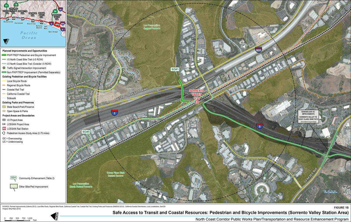
3.1.1 Sorrento Valley Station Area (Figure 1B)
The improvements near Sorrento Valley Station will broaden access to LOSSAN rail services by creating stronger links between the station and several major employment and residential communities of northern San Diego. The ¾-mile station area includes parts of the communities of Sorrento Valley, Torrey Hills, and University City, and also contains the elevated profile of the merging I-5 and I-805 highways. The following three significant projects will provide bicyclists and pedestrians with greater access to the rail corridor, allow for safer connections between UCSD and LOSSAN rail services, and increase access to recreational opportunities:
- Los Peñasquitos Creek Trail Connection (SD#1) will construct a trail connection under the merging I-5 and I-805 highway structures in the Caltrans right-of-way from Los Peñasquitos Creek to Sorrento Valley Road. This project will create better linkages among the Sorrento Valley Station, the residential and commercial developments near Sorrento Valley Road, and the existing recreational trails at Los Peñasquitos Creek.
- Sorrento Valley to Voigt Class I Bike Trail will construct a new Class I facility from Sorrento Valley Road to Voigt Drive at UCSD, eliminating the need for bicyclists to make the steep journey while riding on the I-5 highway shoulder. This project will enhance access to the Sorrento Valley Station from the dense housing and employment areas in University City and will provide access to the adjacent trail project SD#1. It will also serve as the southern end of the I-5 North Coast Bike Trail, whose planned alignment will continue north along Sorrento Valley Road. As noted in Section 2.3, this project is being permitted separately from the PWP/TREP.
- I-5 North Coast Bike Trail in the City of San Diego (SD#5) will share the Sorrento Valley to Voigt Class I Bike Trail and is then planned to continue north along Sorrento Valley Road. As Sorrento Valley Road is outside the I-5 highway right-of-way, this segment will not be built by Caltrans during highway construction and will instead require future planning coordination with the City of San Diego.
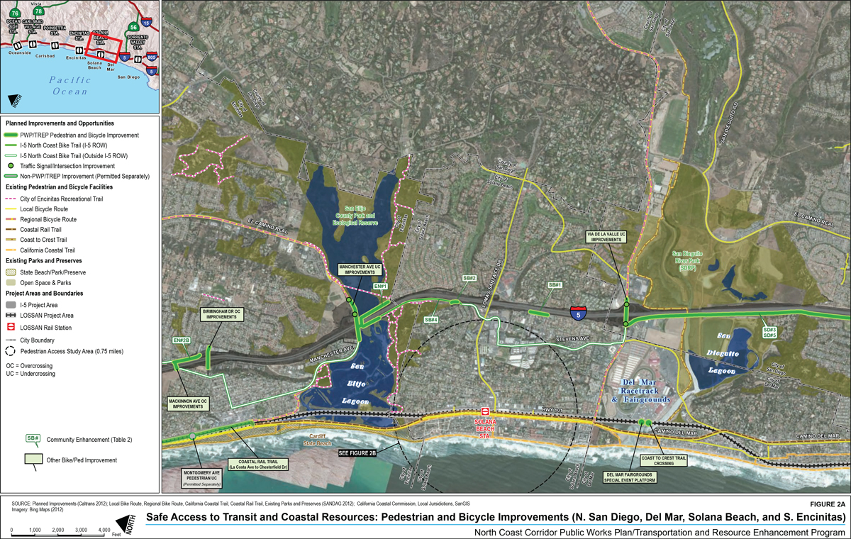
3.1.2 Solana Beach Station Area (Figure 2B)
There is one planned bicycle or pedestrian improvement planned for the ¾-mile area surrounding the Solana Beach Station:
- I-5 North Coast Bike Trail in the City of Solana Beach (SB#4) is planned to share Stevens Avenue and San Rodolfo Drive within the station area. The improvement will connect to the Class II bicycle lanes on Lomas Santa Fe Drive that provide access to Solana Beach Station. As this portion of the alignment is outside the highway right-of-way, it will not be built by Caltrans during highway construction, and will instead require future planning coordination with the City of Solana Beach.
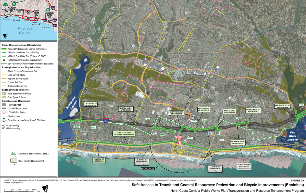
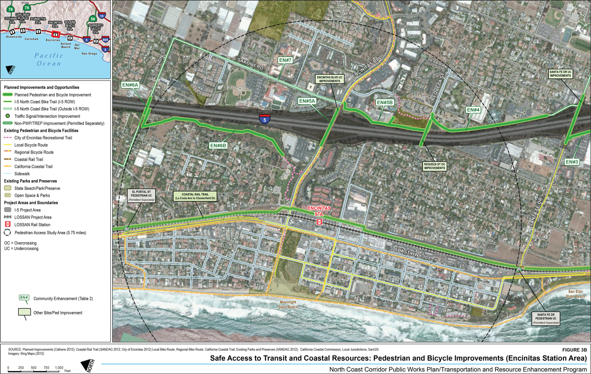
3.1.3 Encinitas Station Area (Figure 3B)
With the I-5 highway and LOSSAN rail corridors in close proximity in Encinitas, the following bicycle and pedestrian improvements in the Encinitas Station area are planned:
- Trail Connecting Santa Fe Drive to Requeza Street with Wetland Revegetation (EN#4) will connect Santa Fe Drive to Requeza Street and include improved drainage and wetland vegetation restoration. In conjunction with the Santa Fe Drive Under-crossing and community enhancement project EN#3 (Hall Property Park Trail Connecting to Santa Fe Drive, shown in Figure 3A), the project will provide bicycle and pedestrian access to the new Hall Property Park. The I-5 North Coast Bike Trail also will share the facility.
- Encinitas Boulevard Bicycle/Pedestrian Enhancements (EN#5A) will provide new 10-foot sidewalks on both sides of Encinitas Boulevard and maintain the existing Class II bicycle lanes. This will enhance pedestrian access to Encinitas Station and coastal resources.
- Trail Connecting Requeza Street to Encinitas Boulevard (EN#5B) will provide a new trail along the east side of I-5 connecting Requeza Street with Encinitas Boulevard. The I-5 North Coast Bike Trail will share the facility. It will connect to project EN#4 to the south, as well as to the existing Class II regional bicycle route along Encinitas Boulevard.
- Union Street Pedestrian Overpass (EN#6A) will construct a new pedestrian and bicycle crossing over I-5, along with a new park on the west side of the bridge in a parcel owned by the City of Encinitas. The I-5 North Coast Bike Trail will share the facility. At its western end, this project will connect to project EN#6B, which will then connect to an existing local trail leading to Encinitas Boulevard; this will provide a new bicycle and pedestrian route across the highway to Encinitas Station.
- Cottonwood Creek Park to Union Street Trail Connection with Wetland Revegetation (EN#6B) will connect Cottonwood Creek Park to Union Street on the west side of I-5. This will connect project EN#6A to the City of Encinitas recreational trail leading to Encinitas Boulevard, creating a new bicycle and pedestrian route across the highway to Encinitas Station.
- I-5 North Coast Bike Trail in the City of Encinitas (EN#7) will include dedicated and shared bicycle facilities in the ¾-mile study area. South of Encinitas Boulevard, the facility will be within the I-5 highway right-of-way and overlap with the community enhancement projects EN#4 and EN#5B. North of Encinitas Boulevard, the trail is planned to share Saxony Road and Union Street. As this shared portion of the alignment is outside the I-5 highway right-of-way, it will not be built by Caltrans during highway construction, and will instead require future planning coordination with the City of Encinitas.
- Requeza Street Over-crossing will provide widened 10-foot sidewalks on both sides of the street, providing safer pedestrian access across the highway. The existing Class III bicycle route will be maintained.
- Coastal Rail Trail (La Costa Avenue to Chesterfield Drive) will construct approximately 7.4 miles of new Class I bicycle facility within or adjacent to the LOSSAN rail right-of-way, to include the 1.5mile segment within the study area surrounding Encinitas Station. This project will provide greater access to both LOSSAN rail services and nearby coastal resources (including Moonlight State Beach). It will also eliminate a major gap in the regional Coastal Rail Trail.
- Santa Fe Drive Pedestrian Under-crossing will provide a new grade-separated access route for pedestrians and bicyclists to cross the rail corridor and access coastal resources, including nearby San Elijo State Beach. It will link the Class II bicycle lanes on Santa Fe Drive with the Coast Highway local bicycle route, the California Coastal Trail, and the planned Coastal Rail Trail segment from La Costa Avenue to Chesterfield Drive. As noted in Section 2.3, this project is being permitted separately from the PWP/TREP.
- El Portal Street Pedestrian Under-crossing will provide a new grade-separated access route across the rail corridor similar to the Santa Fe Drive under-crossing. It will provide connections to the Coast Highway local bicycle route, the California Coastal Trail, and the planned Coastal Rail Trail segment from La Costa Avenue to Chesterfield Drive. As noted in Section 2.3, this project is being permitted separately from the PWP/TREP.
3.1.4 Carlsbad Poinsettia Station Area (Figure 4B)
The bicycle and pedestrian improvements planned for the ¾-mile vicinity around Poinsettia Station consist of the following one highway crossing, one rail crossing, and two regional bicycle facilities that will share the same alignment:
- Poinsettia Lane Over-crossing will widen sidewalks to 12 feet and maintain Class II bicycle lanes on both sides of the roadway. This will increase access to both Poinsettia Station and South Carlsbad State Beach from the dense residential areas just east of the highway.
- Poinsettia Station Pedestrian Over-crossing will provide a new grade-separated crossing of the LOSSAN rail corridor adjacent to Poinsettia Station. It will replace the existing at-grade crossing and connect to the existing trail west of the tracks, providing pedestrians with an unimpeded route to South Carlsbad State Beach. This improvement will increase the safety of pedestrians as well as the reliability of LOSSAN rail services, which will no longer have to slow or stop for the at-grade crossing.
- I-5 North Coast Bike Trail in the City of Carlsbad (CB#4) will share the alignment of the Coastal Rail Trail within the ¾-mile study area, and will include dedicated and shared bicycle facilities. South of Carlsbad Poinsettia Station, Class II bicycle lanes are already constructed along Avenida Encinas. North of the station, a new Class I facility will be constructed within or adjacent to the LOSSAN right-of-way.
- Coastal Rail Trail (Tamarack Avenue to Poinsettia Station) will construct approximately 2.8 miles of new Class I bicycle facility within or adjacent to the LOSSAN rail right-of-way. This will begin near Carlsbad Poinsettia Station–at the end of the existing Class II facility on Avenida Encinas–and will continue north to Tamarack Avenue.
3.1.5 Carlsbad Village Station Area (Figure 5B)
In addition to the planned alignment of the I-5 North Coast Bike Trail near Carlsbad Village Station, three highway crossings also fall within the ¾-mile study area–all of which will receive an upgraded bicycle and pedestrian facilities. The planned projects are the following:
- Chestnut Avenue Under-crossing will widen existing sidewalks from 5 feet to 10 feet and construct new Class II bicycle lanes on each side of the roadway. This will provide safer routes across the highway for pedestrians and bicyclists, increasing their access to Carlsbad Village Station and nearby coastal resources such as Carlsbad State Beach. It also will provide better linkages to the Class II bicycle lanes that continue along Chestnut Avenue to the east of the highway, and also along nearby Harding Street to the west of the highway.
- Carlsbad Village Drive Under-crossing will widen existing sidewalks to 10 feet and construct new Class II bicycle lanes on each side of the roadway. As with the Chestnut Avenue Under-crossing, this project will provide a safer way for pedestrians and bicyclists to cross the highway to access transit and coastal resources.
- Las Flores Drive Over-crossing will widen the existing eastbound sidewalk to 10 feet and construct a new 10-foot westbound sidewalk. The existing Class III bicycle route will be maintained, which is consistent with the city's bicycle master plan.
- I-5 North Coast Bike Trail in the City of Carlsbad (CB#4) will share facilities with the Coastal Rail Trail in the vicinity of Carlsbad Village Station. Part of this facility (from Oak Avenue to the southern edge of the ¾-mile study area) is already constructed as a Class I bicycle path. The remaining northern portion of the route (currently in the design phase) is planned as a Class III shared facility along State Street.
3.1.6 Oceanside Station Area (Figure 6B)
The following planned bicycle and pedestrian improvements near Oceanside Station are mostly adjacent to the highway, owing to the fact that the Coastal Rail Trail and other facilities adjacent to the LOSSAN rail corridor are already constructed or nearing completion:
- Division Street Bicycle/Pedestrian Enhancements (OC#3) will transform the existing 5.5-foot single sidewalk into two 17-foot sidewalks on each side of the over-crossing. It also will provide widened sidewalks on Brooks Street, located just east of the highway, providing a safer connection to Ron Ortega Recreation Park. Existing Class III bicycle facilities will be maintained.
- Mission Avenue Bicycle/Pedestrian Enhancements (OC#4) will widen the eastbound sidewalk to 17 feet and the westbound sidewalk to 12 feet, as well as provide Class II bicycle lanes in both directions. In addition, the project will realign the highway on- and off-ramps to allow for signalized pedestrian crossings. This will provide safer access for bicyclists and pedestrians crossing the highway to access Oceanside Station, and connect to the existing Class II bicycle lanes that extend east on Mission Avenue.
- Bush Street Bicycle/Pedestrian Enhancements and Community Gardens (OC#5) will connect the existing community gardens at Civic Center Drive and Witzel Street (west of I-5) with new community garden plots on the east side of I-5. It will also install a paved trail from the east side of the over-crossing to Buena Street, new and improved lighting and landscaping features, and wider sidewalks on Buena Street and Santa Barbara Street.
- I-5 North Coast Bike Trail in the City of Oceanside (OC#11) will share facilities with the Coastal Rail Trail in the vicinity of Oceanside Station. East of the station, a Class I facility is under construction. West of the station, both bicycle routes will share city streets as Class III facilities. This will improve connectivity for bicyclists and pedestrians to and from Oceanside Station, which is served by LOSSAN rail services as well as the east-west SPRINTER light-rail transit to Escondido.
- Fourth Street/Bush Street Over-crossing will connect the existing community gardens west of the highway to the residential and commercial areas east of the highway, installing new 17-foot (eastbound) and 10-foot (westbound) sidewalks. Class III bicycle facilities will be maintained.
- Neptune Way Over-crossing will widen existing sidewalks from 5 feet to 10 feet and maintain a Class III bicycle facility. Neptune Way is the only access route for the residential development east of the highway to reach the rest of Oceanside, including transit and coastal resources. This project will provide improved pedestrian accessibility for this isolated residential community.
4.0 Analysis of Additional Opportunities for Pedestrian And Bicycle Improvements
In addition to the I-5 North Coast Bike Trail, Coastal Rail Trail, and pedestrian and bicycle enhancements within the highway and rail rights-of-way included in the PWP/TREP, this study investigated additional opportunities for improvements to the regional bicycle network (based on SANDAG's 2010 Regional Bicycle Plan), local bicycle networks (based on the cities' bicycle master plans), and in the local pedestrian networks (based on the San Diego Regional Sidewalk Network GIS database of existing sidewalks and local pedestrian plans) across the I-5 highway or LOSSAN rail corridor or within a ¾-mile radius of LOSSAN rail stations.3
4.1 Improvement Opportunities Adjacent to The I-5 Corridor
Pedestrian and bicycle facilities in the I-5 highway corridor will undergo major improvements with very few crossings left unmodified. The few remaining improvement opportunities are analyzed below.
4.1.1 Pedestrian Opportunities
As discussed in Section 2.1 and shown in Table 1, local roads cross I-5 at 32 locations in the NCC, and one new crossing is planned. The planned highway improvements will incorporate sidewalk enhancements at most of the over-crossing and under-crossing locations. Of the local-road crossing locations that do not include sidewalk enhancements:
- Carmel Mountain Road Under-crossing (San Diego) includes 5-foot sidewalks on both sides of the under-crossing. Therefore, it does not present a barrier to pedestrians.
- Lomas Santa Fe Drive Under-crossing (San Diego) has 5.5-foot sidewalks on both sides. Therefore, it does not present a barrier to pedestrians.
- Carmel Valley Road/SR 56 Under-crossing (San Diego) has 5-foot sidewalks on both sides. Therefore, it does not present a barrier to pedestrians.
- Cannon Road Under-crossing (Carlsbad) has 6-foot sidewalks on both sides. Therefore, it does not present a barrier to pedestrians.
No additional pedestrian enhancement project opportunities were identified for I-5 at existing crossings.
4.1.2 Bicycle Opportunities
The PWP/TREP improvements will upgrade Class III bicycle routes to Class II facilities at 15 crossing locations at I-5, will add a Class II facility at the new Gilman Drive over-crossing, and will maintain existing facility classes at the remaining 17 local-road crossings as well as the San Luis Rey River Trail (two Class I, seven Class II and nine Class III). With the exception of the two Class, I facilities at Lomas Santa Fe Drive and the San Luis Rey River Trail, the existing and planned bicycle networks in the NCC do not include any additional Class I crossings of the highway. Therefore, additional upgrades of Class II facilities to Class I at I-5 crossings are not proposed since there would be no connecting Class I networks.
Of the nine highway crossings where Class III facilities will be maintained, an analysis was conducted to determine whether there are opportunities to upgrade to Class II facilities. The analysis identified whether the crossings are on the proposed Regional Bicycle Master Plan and whether any were identified as barriers to the regional Bicycle Barriers Model.4 Further analysis examined whether each crossing is on the existing local bicycle network, whether there is an existing Class II network to connect with, and whether the local jurisdictions' bicycle master plans propose an upgrade or a new Class II facility. The analysis also considered that all PWP/TREP over-crossing and under-crossing projects will provide Class III facilities at a minimum, and therefore will address the barriers identified in the Regional Barrier Model. As a result, the barriers identified in the Regional Barrier Model are not considered to be determining factors in identifying additional opportunities for bicycle projects in the PWP/TREP. Finally, the analysis determined that upgrades to Class II crossings would have little value if there are no existing or planned Class II networks to connect with. The best opportunities for additional bicycle enhancements are those in which an upgrade from a Class III to Class II bicycle crossing would connect with an existing or planned Class II facility. The analysis found that the PWP/TREP has already identified all opportunities for bicycle network improvements and there are no additional opportunities. Table 4 summarizes the results of this analysis for the nine crossings.
The Carmel Valley Road/SR 56 crossing currently contains Class III facilities and is designated as a regional bicycle route. It facilitates the connection between Carmel Valley Road to the west of I-5 (which contains both Class II and Class III facilities) and a Class I bicycle facility that begins near El Camino Real to the east of I-5. This crossing is not considered a candidate for upgrade to Class II facilities because it will be superseded by community enhancement project SD#2A (Carmel Valley Bicycle/Pedestrian Enhanced Trail Connection). This project will provide a Class I under-crossing just south of Carmel Valley Road, which will allow bicyclists to cross the highway without having to ride on either Carmel Valley Road or El Camino Real.
At Carmel Mountain Road, where there is no project planned, there is a Class II bicycle lane on both sides of the under-crossing. The under-crossing is not on the regional bicycle network. The location, however, was identified as a barrier to the Bicycle Barriers Model. Further examination of this site may reveal the reason this is identified as a barrier and identify possible transportation management solutions short of an infrastructure project (such as a change in signage, traffic signal or intersection striping) that could eliminate or alleviate this barrier.
4.2 Improvement Opportunities Adjacent to the LOSSAN Rail Corridor
Many pedestrian and bicycle routes adjacent to the LOSSAN rail corridor already contain facilities such as paved sidewalks and Class II bicycle lanes. The few remaining improvement opportunities are analyzed in Table 3, but as they are still dependent upon ongoing project scope development, the opportunities identified remain tentative.
Potential pedestrian opportunities include sidewalk enhancements at the following locations:
- Leucadia Boulevard At-Grade Crossing (Encinitas) has a low-quality sidewalk on the north side and no sidewalk on the south side, making it a potential opportunity for sidewalk improvement. However, this project is being considered for grade separation, which would render improvements unnecessary.
- La Costa Avenue Over-crossing (Encinitas) has a sidewalk only on the south side. This is a potential opportunity for sidewalk improvement.
- Carlsbad Boulevard (Carlsbad) has a sidewalk only on the south side. This is a potential opportunity for sidewalk improvement.
Additionally, the following are two potential opportunities for bicycle improvements:
- Chesterfield Drive At-Grade Crossing (Encinitas) contains no bicycle lanes but connects to Class II lanes on Coast Highway that run parallel to the tracks. This is a potential opportunity for bicycle facility improvement.
- Leucadia Boulevard At-Grade Crossing (Encinitas) contains a narrow Class II bicycle lane on the north side and no bicycle lane on the south side. It connects to existing Class II lanes on Leucadia Boulevard and Coast Highway, making this crossing a potential opportunity for improvement. However, this project is being considered for grade separation, which would render improvements unnecessary.
Finally, two LOSSAN crossings (Del Mar Scenic Parkway and North Torrey Pines Road) contain potential opportunities for pedestrian or bicycle improvements but are dependent upon the selection of a project alternative for the Del Mar Tunnel. If the tunnel is approved for construction as planned, these improvements will be unnecessary.
4.3 Other Access Improvement Opportunities Near Transit Stations
The LOSSAN rail corridor is the backbone of the public transit network in the NCC. The success of the rail line is directly related to its convenience and ease of use, and difficulty accessing rail stations serves as a deterrent to potential riders. In addition to access by car or local bus, many people travel between the rail stations and nearby homes, schools or activity centers by bicycle or on foot. Safe, direct, and convenient bicycle and pedestrian infrastructure (such as bicycle lanes, sidewalks, pathways, and roadway crossings) within the vicinity of the rail stations encourage access to the LOSSAN rail corridor.
As noted in Section 3, Figures 1B-6B identifies ¾-mile catchment areas around each LOSSAN rail station, which represents an average person's maximum walking distance to or from transit. The figures also show the existing sidewalks and other pedestrian facilities within these catchment areas, which were derived from local pedestrian master plans (when available) and the San Diego Regional Sidewalk Network. The figures indicate the extent of localized pedestrian access to rail stations as well as adjacent coastal resources; as shown, some NCC communities have more extensive pedestrian networks than others.
The ¾-mile catchment areas include substantial areas outside the I-5 highway and LOSSAN rail rights-of-way. While there may be opportunities to improve pedestrian access in these areas, the implementation of any improvements outside the highway or rail rights-of-way would be the responsibility of local jurisdictions. Figures 1b-6b provide a resource for assessing opportunities to improve access to rail stations within the ¾-mile radius.
Table 1: Planned Pedestrian and Bicycle Improvements at Interstate 5 Local-Road Crossings
| I-5 Overcrossing Bridges | Replace Or New / Widening | Permitting Document | Existing Sidewalk | Proposed Sidewalk* | Pedestrian Improvements | Existing Bicycle Facility | Proposed Bicycle Facility | Bicycle Improvements |
|---|---|---|---|---|---|---|---|---|
| Voigt Dr OC & Realignment | Replace | PWP | Yes | 15' sidewalks | Widen both sidewalks to 15' | Class III/Shared Use | Class II | New Class II bike lanes |
| Del Mar Heights Rd OC | Replace | PWP | Yes = 5' | 12' sidewalks | Widen both sidewalks to 12' | Class II | Class II | Maintain existing |
| Birmingham Dr OC | Replace | PWP | Yes (WB) = 5' | 12' sidewalks |
|
Class III/Shared Use | Class III/Shared Use | Maintain existing |
| Mackinnon Ave OC** | Replace | PWP | Yes = 5.5' | 17' sidewalks | Widen both sidewalks to 17’ | Class III/Shared Use | Class II | New Class II bike lanes |
| Requeza St OC** | Replace | PWP | Yes – EB = 6'. WB = 2' | 10' sidewalks | Widen both sidewalks to 10' | Class III/Shared Use | Class III/Shared Use | Maintain existing |
| Leucadia Blvd OC | Replace | PWP | Yes = 5' | 12' sidewalks | Widen both sidewalks to 12' | Class III/Shared Use | Class II | New Class II bike lanes |
| La Costa Ave OC** | Replace | PWP | Yes = 5' | 12' sidewalks | Widen both sidewalks to 12' | Class II | Class II | Maintain existing |
| Poinsettia Lane OC | Replace | PWP | Yes = 6' | 12' sidewalks | Widen both sidewalks to 12' | Class II | Class II | Maintain existing |
| Palomar Airport Rd OC | Replace | PWP | Yes – WB = 6' + EB = 5- 6' |
10' sidewalks | Widen both sidewalks to 10' | Class III/Shared Use | Class II | New Class II bike lanes |
| Chinquapin Ave OC | Replace | PWP | Yes – WB = 6' | 10' sidewalks |
|
Class III/Shared Use | Class III/Shared Use | Maintain existing |
| Tamarack Ave OC | Replace | PWP | Yes = 6' | 12' sidewalks | Widen both sidewalks to 12' | Class III/Shared Use | Class II | New Class II bike lanes |
| Las Flores Dr OC | Replace | PWP | Yes – EB = 6' | 10' sidewalks |
|
Class III/Shared Use | Class III/Shared Use | Maintain existing |
| Jefferson St OC | Replace | PWP | Yes – WB = 6' | 10' sidewalks |
|
Class III/Shared Use | Class II | New Class II bike lanes |
| Cassidy St OC | Replace | PWP | Yes – EB = 5.5' | 10' sidewalks |
|
Class III/Shared Use | Class III/Shared Use | Maintain existing |
| California St OC** | Replace | PWP | Yes – EB = 5' | 17' sidewalks |
|
Class III/Shared Use | Class II | New Class II bike lanes |
| Brooks/Division St OC** | Replace | PWP | Yes – WB = 5.5' | 17' sidewalks |
|
Class III/Shared Use | Class III/Shared Use | Maintain existing |
| Mission Ave OC** | Replace | PWP | Yes – WB = 4.6', EB = 5' | 17'S/12'N sidewalks |
|
Class III/Shared Use | Class II | New Class II bike lanes |
| Fourth St / Bush St OC** | Replace | PWP | Yes = 5' | 17'S/10'N sidewalks |
|
Class III/Shared Use | Class III/Shared Use | Maintain existing |
| Neptune Way / 8th St OC | Replace | PWP | Yes = 5' | 10' sidewalks | Widen both sidewalks to 10' | Class III/Shared Use | Class III/Shared Use | Maintain existing |
| Gilman OC | New bridge | Outside PWP | N/A | 8' sidewalks | New 8' sidewalk | N/A | Class II | New Class II bike lanes |
| Genesee OC *** | Replace | Outside PWP | No | 8' sidewalks | New 8' sidewalks | Class III/Shared Use | Class II | New Class II bike lanes |
| Carmel Mountain Road | No | N/A | Yes = 5' | N/A | N/A | Class II | N/A | N/A |
| Carmel Valley Road /SR 56* | Yes | PWP | Yes = 5' | 5' sidewalks | Maintain existing | Class III/Shared Use | Class III/Shared Use | Maintain existing |
| Via De La Valle UC | Yes | PWP | Yes – WB = 5', EB = 3-4' | 10' sidewalks | Widen both sidewalks to 10' | Class III/Shared Use | Class II | New Class II bike lane |
| Lomas Santa Fe UC | Yes | PWP | Yes – WB & EB = 5.5' | 5.5' sidewalks | Maintain existing | Class I | Class I | Maintain existing |
| Manchester Ave UC (part of San Elijo lagoon bridge) | Yes | PWP | No | Sidewalk is part of the San Elijo Trail project | New sidewalk is part of the San Elijo Trail project | Class III/Shared Use | Class II | New Class II bike lanes |
| Santa Fe Dr UC** | Yes | PWP | Barrier sep. 5' sidewalk | 10' sidewalks | Widen both sidewalks to 10' | Class III/Shared Use | Class II | New Class II bike lanes |
| Encinitas Blvd UC** | Yes | PWP | No | 10' sidewalks | New 10' sidewalk on both sides | Class II | Class II | Maintain existing |
| Cannon Rd UC | Yes | PWP | Yes = 6' | 6' sidewalks | Maintain existing | Class II | Class II | Maintain existing |
| Chestnut Ave UC | Yes | PWP | Yes = 5' | 10' sidewalks | Widen both sidewalks to 10' | Class III/Shared Use | Class II | New Class II bike lanes |
| Carlsbad Village Dr UC | Yes | PWP | Yes = 6' | 10' sidewalks | Widen both sidewalks to 10' | Class III/Shared Use | Class II | New Class II bike lanes |
| Oceanside Blvd UC** | Yes | PWP | Yes – WB = 5.5', EB = 6' | 10' sidewalks | Widen both sidewalks to 10' | Class II | Class II | Maintain existing |
| Harbor Drive / Camp Pendleton UC** | Yes | PWP | Yes – EB = 3' | 8' EB Sidewalk | Widen eastbound sidewalk to 8' | Class III/Shared Use | Class II | New Class II bike lanes |
| San Luis Rey River Trail**** | Yes | PWP | 10' Tunnel | 12' trail & maintain tunnel |
|
Class I | Class I | Maintain existing on new 12' trail |
Table 2: PWP/TREP [edestroam. Bicycle and Trail Community Enhancement Projects
| Enhancement Project | Project No. | City | Pedestrian Improvement (Paved Sidewalk) | Bicycle Improvement (Class I, II and III) | Unpaved Trail Improvement | Coordinated with PWP Project |
|---|---|---|---|---|---|---|
| Los Peñasquitos Creek Trail Connection* | SD#1 | San Diego | Sidewalk connections from the existing sidewalk to the trail below at Vista Sorrento Parkway | N/A |
|
|
| Carmel Valley Bicycle/Pedestrian Trail Connection* | SD#2A | San Diego |
|
Improved trail connections |
|
|
| Old Sorrento Valley Road Bicycle/Pedestrian Enhanced Trail Connections from Carmel Valley Road (SR 56) to Carmel Mountain Road | SD#2C | San Diego | N/A | Class I 12' wide bicycle lane | N/A |
|
| Bicycle/Pedestrian Trail & Bridge on West Side of I-5 at San Dieguito Lagoon | SD#3 | San Diego |
|
N/A |
|
|
| Pedestrian Overpass Connection North of Del Mar Heights Road | SD#4 | San Diego | A new 12' wide pedestrian and bicycle bridge with connecting sidewalks | N/A | 2 EL from SR 56 to Manchester | |
| I-5 NC Bike Trail in the City of San Diego (in I-5 ROW) | SD#5 | San Diego | Varying pedestrian and bicycle network (Class I, II and III) improvements along I-5 NC | N/A | 2 EL from SR 56 to Manchester within the city borders | |
| Streetscape Enhancements on Ida Avenue* | SB#1 | Solana Beach | Concrete sidewalk on the west side of Ida Ave | N/A | N/A | 2 EL from SR 56 to Manchester |
| Pedestrian Trailhead at Solana Hills Drive* | SB#2 | Solana Beach | Sidewalk along Solana Hills Drive | N/A | Trail head and connection between the north end of Solana Hills Drive trails and San Elijo Lagoon Ecological Reserve | 2 EL from SR 56 to Manchester |
Gateway Open Space Preservation Site |
SB#3 | Solana Beach | N/A | N/A | N/A | N/A |
| I-5 NC Bike Trail in the City of Solana Beach (in I-5 ROW) | SB#4 | Solana Beach | Varying pedestrian and bicycle network (Class I, II and III) improvements along I-5 NC | N/A | 2 EL from SR 56 to Manchester, within the city borders | |
| Bicycle/Pedestrian Trail on Both Sides of I-5 at San Elijo Lagoon With Bridge* | EN#1 | Encinitas |
|
Suspended N-S pedestrian bridge across San Elijo Lagoon |
|
|
| Villa Cardiff Dr & MacKinnon Ave Bridge Enhancements* | EN#2B | Encinitas |
|
N/A |
|
|
| Hall Property Park Trail Connecting to Santa Fe Drive* | EN#3 | Encinitas | N/A | N/A | 8' wide trail between Santa Fe Drive traffic circle and Hall Property Park on west side of I-5 |
|
| Trail Connecting Santa Fe Drive to Requeza Street with Wetland Revegetation* | EN#4 | Encinitas | N/A | N/A | 12' wide trail between Santa Fe Drive and Requeza Street on the east side of I-5 | 2 EL from Manchester to Palomar Airport Road |
| Encinitas Boulevard Bicycle/Pedestrian Enhancements | EN#5A | Encinitas | New 10' sidewalk on both sides of undercrossing | N/A | N/A |
|
| Trail Connecting Requeza Street to Encinitas Boulevard* | EN#5B | Encinitas | N/A | N/A | 12' wide trail between Requeza Street and Encinitas Blvd. on the east side of I-5 | 2 EL from Manchester to Palomar Airport Road |
| Union Street Pedestrian Overpass* | EN#6A | Encinitas | New 12' pedestrian-bicycle overcrossing with sidewalk connection to trail | 2 EL from Manchester to Palomar Airport Road | ||
| Cottonwood Creek Park to Union Street Trail Connection with Wetland Revegetation* | EN#6B | Encinitas | N/A | N/A | 8' wide trail from Cottonwood Creek Park to Union Street on the west side of I-5 | 2 EL from Manchester to Palomar Airport Road |
| I-5 NC Bike Trail in the City of Encinitas (in I-5 ROW) | EN#7 | Encinitas | Varying pedestrian and bicycle network (Class I, II and III) improvements along I-5 NC | N/A | 2 HOV lanes & noise barriers Manchester to SR 78 between Manchester Ave and the city border | |
| Bicycle/Pedestrian Trail & Bridge on West Side of Batiquitos Lagoon | CB#1A | Carlsbad | N/A | N/A | Decomposed granite 12' wide trail connecting east to west under I-5 and to existing trails, including a bridge crossing under I-5 connecting north and south sides of the lagoon |
|
| Park and Ride Enhancement at La Costa Avenue* | CB#1B | Carlsbad | N/A | N/A | Enhanced Park and Ride will serve as trail head | 2 EL from Manchester to Palomar Airport Road |
| Trail on Northeast Side of I-5 at Batiquitos Lagoon* | CB#2 | Carlsbad | N/A | N/A | Trail connection to existing trail to hanging bridge |
|
| Bicycle/Pedestrian Trail & Bridge on East Side of I-5 at Agua Hedionda Lagoon* | CB#3 | Carlsbad | N/A | N/A |
|
|
| I-5 NC Bike Trail in the City of Carlsbad (in I-5 ROW) | CB#4 | Carlsbad | Varying pedestrian and bicycle network (Class I, II and III) improvements along I-5 NC | N/A | 2 EL from Palomar Airport Rd to SR 78 within the city borders | |
| Pocket Park and Pedestrian Path at California Street* | OC#1 | Oceanside | Walkway connecting Moreno Way with California Street, enhanced crossings on Soto Street intersections with California and Valencia Streets | N/A | N/A |
|
| Oceanside Boulevard Pedestrian Streetscape Enhancement* | OC#2 | Oceanside | 10' sidewalk on both sides | N/A | N/A |
|
| Division Street Bicycle/Pedestrian Enhancements* | OC#3 | Oceanside |
|
N/A | N/A |
|
| Enhanced Pedestrian Overpass Connection on Mission Avenue* | OC#4 | Oceanside |
|
N/A | N/A |
|
| Bush Street Bicycle/Pedestrian Enhancements & Community Gardens* | OC#5 | Oceanside |
|
N/A | Paved trail from the east side of the bridge along the on-ramp to Buena Street |
|
| SR76 Underpass: New Parking & Trailhead* | OC#7 | Oceanside |
|
N/A | 4 EL from SR 78 to Harbor Dr, San Luis Rey River Trail widening, SR-76 UC widening | |
| Pedestrian Underpass Improvements North of San Luis Rey River* | OC#8 | Oceanside | Widened sidewalk of underpass under I-5 with stairs and ramp connections that meet American with Disabilities Act requirements, optional sidewalk between San Luis Rey Drive and Monterey Drive | N/A | Optional accessible ramp and trail from undercrossing to trail along north shore of river | 4 EL from SR 78 to Harbor Dr |
| Harbor Drive/Camp Pendleton Bicycle/Pedestrian Enhancements | OC#10 | Oceanside | Widen EB sidewalk to 8' | New Class II bike lanes | N/A | 4 EL from SR 78 to Harbor Dr, Harbor Drive Undercrossing widening |
| I-5 NC Bike Trail in the City of Oceanside (in I-5 ROW)** | OC#11 | Oceanside | Varying pedestrian and bicycle network (Class I, II and III) improvements along I-5 NC | N/A | 2 HOV lanes & noise barriers Manchester to SR 78, between Manchester Ave and the city border | |
Table 3: Planned Pedestran and Bicycle Network Improvements Across LOSSAN Corridor
| Existing Local Street Crossings | Existing Crossing Type | Jurisdiction | LOSSAN Project Area | Current Pedestrian Infrastructure | Planned Ped Infrastructure as Part of Rail Project | Current Bicycle Infrastructure | Planned Bike Improvement as Part of Rail Project |
|---|---|---|---|---|---|---|---|
| Sorrento Valley Blvd | At-Grade Double track | San Diego | No future project planned | Sidewalk on both sides | N/A | Class II bike lanes on both sides | To be determined. Dependent upon tunnel alternatives analysis |
| Del Mar Scenic Pkwy | UC Single Track | San Diego | Del Mar Tunnel Analysis | Access road to a parking lot sidewalk on south side only | To be determined. Dependent upon tunnel alternatives analysis | No bike lanes | N/A |
| N. Torrey Pines Road / County Hwy S21 | OC Single Track | San Diego | Del Mar Tunnel Analysis | Sidewalk on East side only | To be determined. Dependent upon tunnel alternatives analysis | Class II bike lanes on both sides | N/A |
| Coast Blvd | At-Grade Single Track | Del Mar | Del Mar Tunnel Analysis | Sidewalks on both sides | N/A | Class II bike lanes on both sides | N/A |
| Camino Del Mar (County Hwy S21) | OC Double Track | Del Mar | Del Mar Tunnel Analysis | Sidewalks on both sides | N/A | Class II bike lanes on both sides | N/A |
| Via De La Valle | OC Single Track | Solana Beach | No future project planned | Sidewalks on both sides | N/A | Class II bike lanes on both sides | N/A |
| Dahlia Dr to Rose St | Ped/Bike OC Double Track | Solana Beach | No future project planned | Pedestrian-bicycle only OC | N/A | Pedestrian-bicycle only OC | N/A |
| Lomas Santa Fe Dr | OC Double Track | Solana Beach | No future project planned | Sidewalks on both sides | N/A | Class II bike lanes on both sides | N/A |
| Cliff St | Ped/Bike OC Double Track | Solana Beach | No future project planned | Pedestrian-bicycle only OC | N/A | Pedestrian-bicycle only OC | N/A |
| Chesterfield Dr | At-Grade Single Track | Encinitas | Cardiff to Craven |
|
N/A | No bike lanes Class II network parallels track does not cross | To be determined. Could be opportunity |
| D St | At-Grade Single Track | Encinitas | Moonlight to Swami |
|
N/A | No bike lanes | To be determined. No current Class II network; future network is Class III |
| E St | At-Grade Single Track | Encinitas | Moonlight to Swami |
|
N/A | No bike lanes | To be determined. No current Class II network; not on future local network |
| Encinitas Blvd | UC Single Track | Encinitas | Moonlight to Swami | Sidewalks on both sides | N/A | Class II bike lanes on both sides | N/A |
| Leucadia Blvd | At-Grade Single Track | Encinitas | Ponto to Moonlight |
|
Potential Grade Separation. If not grade-separated then could be opportunity for sidewalk enhancement* | Narrow Class II bike lane on north side | Potential Grade Separation. If not grade-separated then could be opportunity for Class II* |
| La Costa Ave | OC Single Track | Encinitas |
Ponto to Moonlight | Sidewalk only on south side | To be determined. Could be opportunity for sidewalk enhancement* | Class II bike lanes | N/A |
| Avenida Encinas | OC Single Track | Carlsbad | Ponto to Moonlight | Sidewalks on both sides | N/A | Class II bike lanes on both sides | N/A |
| Poinsettia Lane | OC Single Track | Carlsbad | Ponto to Moonlight | Sidewalks on both sides | N/A | Class II bike lanes on both sides | N/A |
| Palomar Airport Rd | OC Single Track | Carlsbad | No future project planned | No sidewalks | N/A | No bike lanes | N/A |
| Cannon Rd | At-Grade Double Track | Carlsbad | No future project planned |
|
N/A | Class II bike lanes on both sides Signaled Grade Crossing | N/A |
| Tamarack Ave | At-Grade Double Track | Carlsbad | No future project planned |
|
N/A | Class II bike lanes on both sides Signaled Grade Crossing | N/A |
| Carlsbad Village Dr | At-Grade Double Track | Carlsbad | Carlsbad Village Double Track |
|
N/A | No bike lanes | To be determined. Future Network is Class III |
| Grand Ave | At-Grade Double Track | Carlsbad | Carlsbad Village Double Track |
|
N/A | No bike lanes | To be determined. Future Network is Class III |
| Carlsbad Blvd | OC Single Track | Carlsbad | Carlsbad Village Double Track | Sidewalks on south side only | To be determined. Could be opportunity for sidewalk enhancement* | Class II bike lanes on both sides | N/A |
| Cassidy Street | At-Grade Double track | Oceanside | No future project planned | Sidewalk on south side only | N/A | No bike lanes | N/A |
| Oceanside Blvd | At-Grade Four tracks | Oceanside | No future project planned | Sidewalk on south side only | N/A | No bike lanes | N/A |
| Wisconsin Ave | At-Grade Four tracks | Oceanside | No future project planned | Sidewalk on south side only | N/A | No bike lanes | N/A |
| Mission Ave | At-Grade Double track | Oceanside | No future project planned | Sidewalk on south side only | N/A | No bike lanes | N/A |
| Pier View Way | UC Double track | Oceanside | No future project planned | Pedestrian/bicycle only | N/A | Pedestrian/bicycle only | N/A |
| Surf Rider Way | At-Grade Single track | Oceanside | Eastbrook to Shell | Sidewalks on both sides | N/A | No bike lanes | N/A |
| San Luis Rey River Trail (Class I) | UC Single track | Oceanside | Eastbrook to Shell |
|
Relocate Path |
|
Relocate Bike Path |
| Harbor Dr / Camp Pendleton UC / Vandegrift Blvd | OC Double track | Oceanside | No future project planned | Sidewalk on south side only | N/A | No bike lanes | N/A |
| Hillcrest Dr** | Ped/Bike UC Single track | Encinitas | Ponto to Moonlight | No crossing | New pedestrian-bicycle only UC | No crossing | New pedestrian-bicycle only UC |
| El Portal St** | Ped/Bike UC Single track | Encinitas | Ponto to Moonlight | No crossing | New pedestrian-bicycle only UC | No crossing | New pedestrian-bicycle only UC |
| Santa Fe Dr** | Ped/Bike UC Single track | Encinitas | No future track project planned | No crossing | New pedestrian-bicycle only UC | No crossing | New pedestrian-bicycle only UC |
| Montgomery Ave** | Ped/Bike UC Single track | Encinitas | No future track project planned | No crossing | New pedestrian-bicycle only UC | No crossing | New pedestrian-bicycle only UC |
| Poinsettia Station** | Ped/Bike UC Single track | Carlsbad | Ponto to Moonlight | At-grade crossing | New pedestrian-bicycle only UC | No crossing | New pedestrian-bicycle only UC |
| Coast to Crest Trail at San Dieguito Lagoon** | Pedestrian trail UC | Del Mar | San Dieguito Lagoon Bridge Replacement | No crossing | New pedestrian-bicycle only UC | No crossing | New pedestrian-bicycle only UC |
Table 4: Additional Opportunities for Bicycle Improvements Across I-5 (Class III Crossing Locations)
| I-5 Overcrossing Bridges | City | Included in Regional Bicycle Network | Identified as Barrier on Regional Barrier Map | Identified in Existing Local Bicycle Network | Existing Class II Network for Connection | Local Bicycle Plan Designation | PWP Project | PWP Project Opportunity |
|---|---|---|---|---|---|---|---|---|
| Carmel Valley Road/SR 56 | San Diego | Yes | Yes | Yes | No | To be determined | Maintain existing Class III | No |
| Birmingham Dr OC | Encinitas | No | Yes | No | No | Future Class III | Maintain existing Class III | No |
| Requeza St OC | Encinitas | No | No | No | No | Future Class III | Maintain existing Class III | No |
| Chinquapin Ave OC | Carlsbad | No | No | Yes | No | Remain Class III | Maintain existing Class III | No |
| Las Flores Dr OC | Carlsbad | No | Yes | No | No | Future Class III | Maintain existing Class III | No |
| Cassidy St OC | Oceanside | No | No | No | No | No bicycle facility recommended | Maintain existing Class III | No |
| Brooks St OC | Oceanside | No | No | No | No | No bicycle facility recommended | Maintain existing Class III | No |
| Fourth St / Bush St OC | Oceanside | No | No | No | No | No bicycle facility recommended | Maintain existing Class III | No |
| Neptune Way / 8th St OC | Oceanside | No | No | No | No | No bicycle facility recommended | Maintain existing Class III | No |
Notes:
- The total exceeds 30 because some projects include a combination of pedestrian, bicycle, and trail enhancements.
- This assumes that pedestrians are willing to walk about 20 minutes, or approximately ¾ of a mile, to a high-quality rapid transit option such as the COASTER. While the Federal Transit Administration (FTA) has established a "one-half mile de facto catchment area for pedestrians around a transit stations," the FTA also supports investments in and "makes eligible for funding pedestrian improvements beyond the one-half mile catchment area if the improvement is within the distance that people could be expected to safely and conveniently walk to use the particular stop or station" ("Final Policy Statement on the Eligibility of Pedestrian and Bicycle Improvements Under Federal Transit Law," Federal Register Vol. 76, No. 161, August 19, 2011).
- Generating a Sidewalk Network for San Diego County: Project Documentation, June 2011, SANDAG and Urban Design for Health, Inc.
- San Diego Regional Bicycle Plan, Appendix A – Existing Conditions Report, Figure 6-4. "The bicycle barrier submodel reflects indications of 'problem areas' such as relatively high crash locations, roadways with high vehicular traffic volumes and speeds, freeway on/off ramps, and steep slopes."