
Interstate 5 Sperry Road Interchange
Project Description
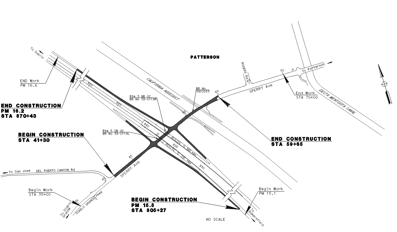
The California Department of Transportation, in conjunction with Stanislaus County and the City of Patterson, proposes to construct improvements to the Interstate 5(I-5)/Sperry Road interchange, in Stanislaus County approximately 2.5 miles west of the City of Patterson. The City of Patterson is sponsoring the project and will be the lead for the design phase. The project would improve operations, enhance safety and increase the capacity of the interchange to accommodate the anticipated demand associated with recent and planned development adjacent to the interchange and in the City of Patterson, in phases.
Ultimate Project Improvement
The proposed project will upgrade the I-5/Sperry Avenue interchange, located west of the City of Patterson, between the Westley and Crows Landing interchanges. The project area is predominantly rural, surrounded by agricultural land uses. The California Aqueduct lies approximately 1,000 feet east of the interchange, and Black Gulch Creek runs along the north side of Sperry Avenue within the project limits.
Proposed Improvements
- Roadway Widening: Sperry Avenue will be widened from two to four lanes between Del Puerto Canyon Road and approximately 300 feet east of the California Aqueduct. Typical widening ranges from 14 to 18 feet on each side, with additional width provided at ramp intersections.
- Ramps: On- and off-ramps will be reconstructed and widened. Auxiliary lanes will be added to the northbound and southbound on-ramps.
- Intersection Control: Existing stop controls (two-way at the northbound ramps and four-way at the southbound ramps) will be replaced with signal control. Ramp metering capability will be included for future implementation.
- Structures: Retaining walls will be constructed along both sides of Sperry Avenue under I-5, as well as short retaining walls for the Department of Water Resources’ secondary access roads. The Sperry Avenue Bridge over the California Aqueduct will be widened to accommodate the expanded roadway.
- Earthwork and Grading: Excavation will be required for pavement structural sections. Widening of tall embankment slopes will also be required east of the northbound on-ramp and west of southbound off-ramp.
- Drainage: A new 0.08-acre drainage basin will be constructed at the northeast quadrant of Sperry Avenue and the I-5 northbound on-ramp. New drainage systems will be installed and tied into existing facilities to maintain the overall drainage pattern.
Phase 1 Project Improvement
The proposed ultimate project will upgrade the I-5/Sperry Avenue interchange, located west of the City of Patterson, between the Westley and Crows Landing interchanges. The project area is predominantly rural, surrounded by agricultural land uses. The California Aqueduct lies approximately 1,000 feet east of the interchange, and Black Gulch Creek runs along the north side of Sperry Avenue within the project limits. Due to budget constraints, the ultimate project will be implemented in phases to address traffic needs as early as possible. Traffic from the southbound off-ramp to eastbound Sperry Avenue has been identified as the most critical issue. Therefore, Phase 1 will focus on the minimum improvements necessary to alleviate this traffic, while ensuring that elements are constructed to ultimate project condition where feasible to avoid future throwaway work. Remaining project improvements will be constructed as separate construction packages as funding becomes available.
Proposed Improvements
- Roadway Widening: An additional eastbound lane will be constructed on Sperry Avenue between the southbound ramps and northbound ramps. Roadway widening will be tapering down to match existing edge of pavement at west of DWR secondary access road.
- Ramps: Minor improvements will be made at the southeast corner of the southbound on-ramp and at the existing northbound off-ramp tie-in to accommodate the Sperry Avenue widening.
- Intersection Control: The existing stop controls (two-way at the northbound ramps and four-way at the southbound ramps) will be replaced with signal control.
- Structures: A retaining wall will be built along the south side of Sperry Avenue under I-5. Additional retaining wall segments will be constructed at the northeast corner of the southbound off-ramp and the northwest corner of the northbound on-ramp to accommodate traffic signal poles at their ultimate locations.
- Earthwork and Grading: Excavation will be required for widened eastbound lane of Sperry Ave under I-5. Embankments at the northeast and southeast corners of the northbound ramps intersection will be constructed to support traffic signal poles. Excavation along the west side of the southbound on-ramp will provide fill material for the embankments.
- Drainage: A new 0.01-acre drainage basin will be constructed at the southeast quadrant of Sperry Avenue and the I-5 northbound off-ramp to capture additional runoff. Ultimate drainage systems will be installed and tied into existing facilities to maintain overall drainage patterns.
Project Benefits
Purpose
- Increase the capacity of the interchange to accommodate existing and future traffic demands
- Improve operations and the movement of goods
- Enhance safety
Need
Improvements to the interchange are necessary to meet the increasing traffic demand associated with continued and planned commercial and industrial growth in the City of Patterson. Currently, the southbound off-ramp intersection operates at level of service (LOS) F in the PM peak period. By 2040, both ramp intersections are predicted to operate at LOS F during both the morning and afternoon peak traffic. Additionally, the project is anticipated to enhance the safety of motorists using this interchange, particularly the southbound off-ramp, which has an elevated incidence of vehicle accidents, as indicated in Section 4C Collision Analysis of this report.
Current Schedule
Fall 2020 (Completed)
Project Approval & Environmental Document (M200)
Fall 2026
Right of Way Certification (M410)
Winter 2027
Ready to List (M460)
Spring 2027
Approved Construction Contract (M500)
Spring 2028
Project Completion (M600)
Funding Source
🌞
Project Status
Project is currently in Plans, Estimates, and Specifications (PS&E) phase.
Project Cost/Programmed (x$1,000):
| Programed Project Cost | Capital $ | Support $ |
|---|---|---|
| Project Approval & Environmental Document | N/A | $1,115 |
| Plans, Specifications, & Estimates | N/A | $2,645 |
| Right of Way | $50 | $10 |
| Construction (Phase 1) | $5,970 | $700 |
| Construction (Phase 2) | $28,000 | $3,000 |
| Projected Cost as of December 2025: | Planned $ | Expended $ |
|---|---|---|
| Project Approval & Environmental Document | $1,115 | $737 |
| Plans, Specifications, & Estimates | $2,645 | $802 |
| Right of Way | $50 | $10 |
| Construction | $0 | $0 |
Public Information Office
Phone: (209) 948-7977
Email: District10PublicAffairs@dot.ca.gov
Address: P.O. Box 2048, Stockton, CA 95201-2048
![]()
Title VI Information
The California Department of Transportation (Caltrans) assures that no person shall, on the basis of race, color, or national origin, be excluded from participation in, be denied the benefits of, or be otherwise subjected to discrimination under any program or activity receiving Federal financial assistance, as required by Title VI of the Civil Rights Act of 1964 , as amended, the Civil Rights Restoration Act of 1987 , and Federal Executive Order 12898 (Federal Actions to Address Environmental Justice in Minority Populations and Low-Income Populations).
Caltrans will make every effort to ensure nondiscrimination in all of its programs and activities, whether they are federally funded or not, and that services and benefits are fairly distributed to all people, regardless of race, color, or national origin. In addition, Caltrans will facilitate meaningful participation in the transportation planning process in a nondiscriminatory manner.
- Title VI Brochure (English, PDF)
- Title VI Brochure (Spanish, PDF)
- Title VI of the Civil Rights Act of 1964 (Caltrans Information)