
Ventura Overhead Bridge Replacement Project
Sign up for Ventura Overhead Bridge Project Notifications
Sign up: https://forms.office.com/g/cwNtQyCe1U?origin=lprLink
If you already receive email updates, please do not sign up again.
Location and Limits
The Ventura Overhead Bridge connects U.S. 101 to State Route 1 (Pacific Coast Highway/SR-1) at the State Beaches exit, just north of the city of Ventura.

Ventura Overhead Bridge No. 52-0040 over the Union Pacific Railroad track and southwest of US-101.
The Project
The $68 million Caltrans project will replace the entire Ventura Overhead Bridge No. 52-0040 over the Union Pacific Railroad (UPRR) track and near the state beaches on SR-1.
Projected Construction Schedule
· Construction began in January 2026.
· Summer 2026 - Open the emergency ramp
· Fall/Winter 2026 - Open temporary pedestrian bridge
· Fall/Winter 2026– Start phase 2 construction - Closing the NB 101 (Exit #72) on – and off-ramps
· Winter 2026 - Remove existing bridge, construct retaining walls
· Spring 2028 – Target project completion
Background
The 91-year-old Ventura Overhead bridge was built in 1934. The existing bridge no longer meets UPRR’s grade separation requirements for horizontal clearance and minimum vertical clearance.
Caltrans determined it was more cost-effective to replace the structure instead of renovating the existing bridge deck, corroded structural steel span members, railing, and concrete bridge columns.

Design image of completed new bridge. (Facing north).
Benefits
The project replaces 34,669 square feet of bridge deck and 1,220 linear feet of bridge rail. The new bridge span will be 614’ long and 55’ wide with approximately 25’ of clearance from below. Benefits include a new, cleaner structure with fewer columns and improved aesthetics. The project will also improve bike and pedestrian path accessibility from Omer Rains Coastal Bike Trail to Emma Wood State Beach. The new bridge will have increased resilience to seismic activity, enhance safety for the traveling public, and meet railroad clearance requirements.
Concerned Communities
Beach communities of Dulah, Faria, and Solimar, the City of Ventura, and Ventura County.
FAQs
Q: Will this project close the freeway at any time?
A: The project will close two highway ramps for up to 18 months:
· The northbound U.S. 101 State Beaches exit (72) to SR-1 (PCH), requiring motorists traveling north on U.S. 101 to continue about 6.5 miles to the Seacliff exit (78) to access beaches along SR-1.
· The SR-1 on-ramp to southbound U.S. 101, requiring motorists, including beach community residents, to travel north to the Seacliff on-ramp to southbound U.S. 101.
· The ramps are expected to be closed starting in Fall/Winter of 2026. The time frame is subject to change.

Map: Location of bridge and ramps.
Q: Will the ramp closures delay first responders from accessing medical, fire or other emergencies?
A: No. A special temporary ramp is being installed in the U.S. 101 median at Lease Canyon Road near the Dulah beach community to provide first responders quick and direct access to SR-1. It can also be used in the event of an evacuation emergency. The public, including local residents, is prohibited from using the ramp that will be equipped with a radio-controlled gate. You may access the Emergency Response Plan here: Emergency Response Plan .
Q: Why is the special temporary ramp not accessible to the public?
A: The ramp's design is substandard for public use. Due to the limited right of way, it lacks the proper acceleration and deceleration merging distances of a standard ramp. The project budget does not allow for the necessary enhancement.
Q: Will local residents be able to open the gate to the emergency ramp themselves?
A: No. First responders have remote control of the gate and will be able to open it quickly in emergencies.
Q: Will this project be noisy at night?
A: Noise levels near project areas will be the same level as ordinary freeway traffic. Caltrans will monitor noise levels during construction to minimize the impact on local neighborhoods. If you experience excessive noise or dust related to this construction project, please contact Caltrans.
Q: Will there be temporary access for pedestrians and bicycles while the new bridge is under construction?
A: Yes.

Southbound along State Route 1:
· Follow the blue arrows on the map.
· Within the north end of the closed section of PCH there will be a designated path and signs that will lead you towards the railroad tracks.
· Then a temporary pedestrian / bike bridge will take you over the railroad tracks to the right shoulder of southbound US-101.
· As you can see in the diagram on the lower left, there will be a pedestrian / bike lane separated from the freeway by barrier and fence. That lane will be about 900 feet long and will return you to the PCH.
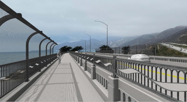
Design image of completed bi-directional bike path, which will run along the ocean side of the new bridge. (Facing north).
Contact Information
For questions contact: PCHVOHB@dot.ca.gov