
Caltrans Heliplates
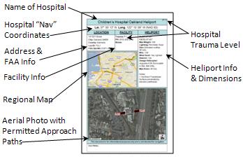
Welcome to the Caltrans Heliplates page. The "Heliplates" provide permitted approach paths and other information for all the permitted Hospital Heliports in California (sample Heliplate shown below). We hope this information will be helpful to emergency planners, helicopter operators, and other users.
You can find the Heliplates on the interactive map below or directly by hospital name.
To access Heliplates:
- Using Interactive Map:
- Use the County dropdown lists to select either County or Geographic Region.
- Hover mouse pointer over the H icon to see Hospital Heliport (HP) Name.
- Click on H, the Heliplate for that Hospital HP will appear. Click on the button to open the Heliplate in a larger view in a new tab.
- Close the Heliplate and use dropdown lists as needed to locate another area or HP.
- Directly:
- If you know the name of the Hospital Heliport, use the Hospital Name dropdown list to select and go directly to that Heliplate. When finished, close the Heliplate to return to the map.
Note: These Heliplates are for informational purposes only and NOT to be used for air navigation.
A Mobile App for the Caltrans Heliplates is now available at the App Store or Google Play.
![]()
![]()