
Caltrans District 9 Middle-Mile Broadband Network Project
Project Information
In July 2021 Governor Gavin Newsom signed into law Senate Bill (SB) 156 to create an open-access Middle-Mile Broadband Network to bring equitable high-speed broadband service to all Californians. SB 156 provides $3.25 billion to build the necessary infrastructure to bring internet connectivity to homes, businesses, and community institutions. The “middle mile” is the physical fiber optic infrastructure needed to enable internet connectivity. It is made up of high-capacity fiber lines that carry large amounts of data at high speeds over long distances. An open-access network gives providers and entities access to broadband infrastructure that will allow any networks to connect on equal economic and service terms.
The Middle-Mile Broadband Network Initiative aims to bring equitable high-speed broadband service to all Californians by developing the necessary infrastructure to bring internet connectivity to homes, businesses, and community institutions. The “middle mile” is the physical fiber optic infrastructure needed to enable internet connectivity. To achieve the overarching goal of constructing 10,000 miles of middle mile broadband infrastructure, the state of California identified approximately 270 individual broadband installation projects to be implemented through phased planning and construction. Each project would function independently to provide fiber cable infrastructure that serves individual communities, by connecting existing hubs and vaults. Potential users could subsequently connect to middle mile broadband infrastructure by installing “last mile” service, ultimately delivering broadband connectivity to the service area.
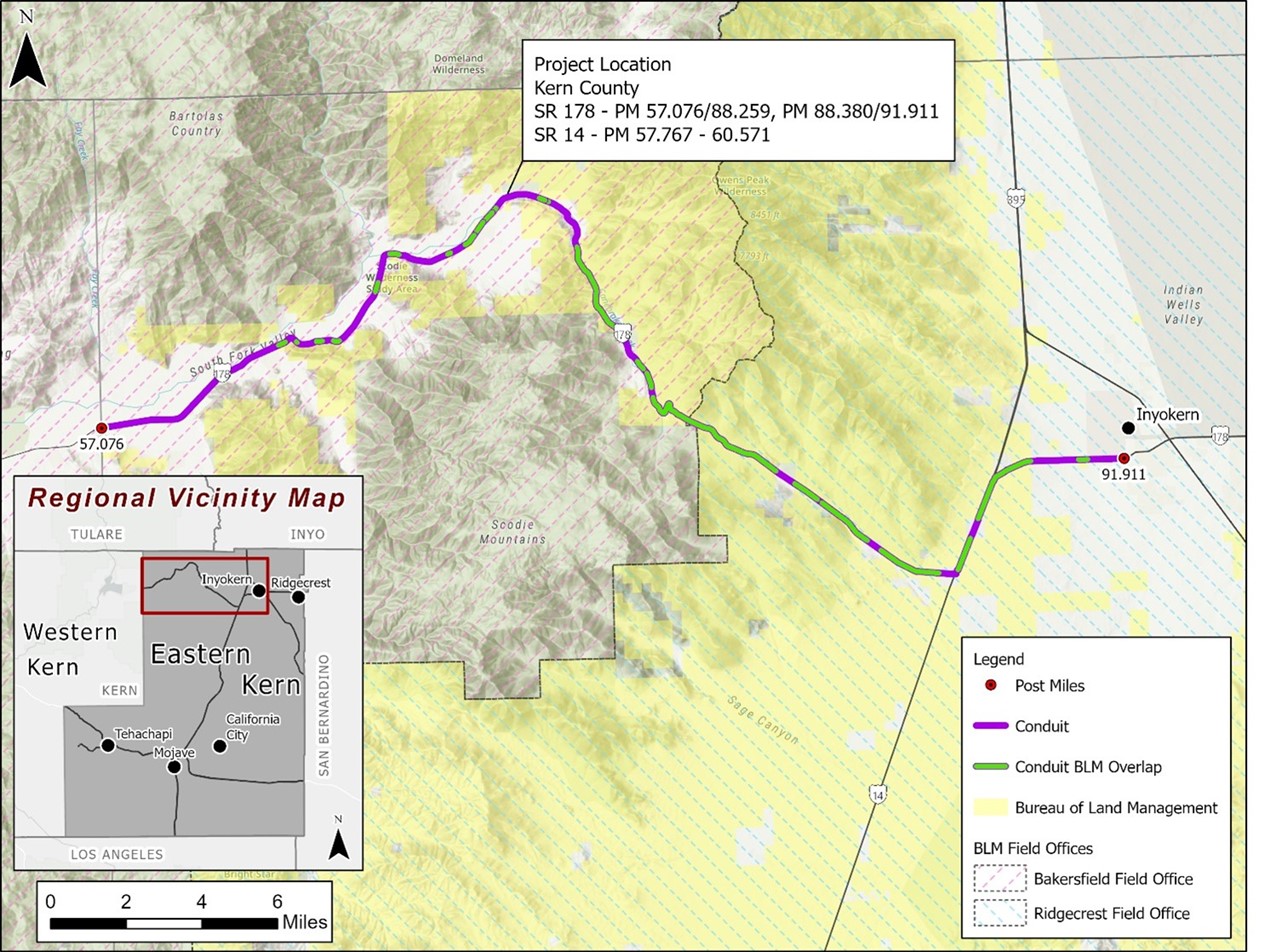
This project would include the installation of an underground Middle-Mile Broadband Network along approximately 37.4 miles of the State Highway System located in Kern County in District 9. This project extends along State Route 178 from 0.7 mile west of Fay Ranch Road to the west junction of State Route 14, then on State Route 14 from the south junction of State Route 178 to the north junction of State Route 178, then on State Route 178 from the east junction of State Route 14 to 0.05 mile west of Red Rock/Inyokern Road. Work will include the installation of subsurface Broadband conduit and fiber as well as the installation of underground vaults approximately every 2,400 feet.
Project Map
Click for a larger image
Draft Environmental Document
Accessibility Assistance: Caltrans makes every attempt to ensure our documents are accessible. Due to variances between assistive technologies, there may be portions of this document which are not accessible. Where documents cannot be made accessible, we are committed to providing alternative access to the content. Should you need additional assistance, please contact us at (916) 654-2852 or visit https://dot.ca.gov/request-ada-compliant-documents.
The Environmental Assessment is available to the public for review: Caltrans District 9 Middle-Mile Broadband Network Project 09-39510 ArcGIS StoryMap and Draft Environmental Document (DED).
Construction PIO Contact
Michael Lingberg
Public Information Officer
Construction
Caltrans District 9
(760) 920-0280
Title VI Information
The California Department of Transportation (Caltrans) assures that no person shall, on the basis of race, color, or national origin, be excluded from participation in, be denied the benefits of, or be otherwise subjected to discrimination under any program or activity receiving Federal financial assistance, as required by Title VI of the Civil Rights Act of 1964, as amended, the Civil Rights Restoration Act of 1987, and Federal Executive Order 12898 (Federal Actions to Address Environmental Justice in Minority Populations and Low-Income Populations).
Caltrans will make every effort to ensure nondiscrimination in all of its programs and activities, whether they are federally funded or not, and that services and benefits are fairly distributed to all people, regardless of race, color, or national origin. In addition, Caltrans will facilitate meaningful participation in the transportation planning process in a nondiscriminatory manner.