
North Madera 6 Lane
Project Description
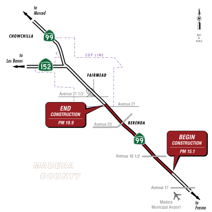
The proposed project would improve State Route 99 from 4 lanes to 6 lanes from post mile 15.1 to post mile 19.9 in Madera County. The project limits extend from 0.5 mile north of the Avenue 17 Overcrossing to 1 mile south of the Avenue 21½ Overcrossing. There is a build alternative (Alternative 1) and a no-build alternative under consideration.
Alternative 1 would construct two lanes within the existing median. The existing lanes and shoulders would be reconstructed using a rehab strategy and upgraded to the standard widths, where feasible. All ramps within the project limits would be overlaid with Hot Mix Asphalt (HMA), as required.
The Berenda Creek Bridge would be improved to accommodate the additional lane and standard shoulder widths. Dry Creek Bridge would be decked in the median to become one structure. New abutments and piers would be constructed for both bridges.
No new right-of-way is anticipated. No temporary construction easements are anticipated. The existing median would be used as a staging area. Existing utilities may need relocation. Median barriers would be installed throughout the project limits. Overhead signs and gore areas would be upgraded to current standards. Drainage facilities would be upgraded and expanded. Complete streets elements, such as sidewalks and crosswalks, would be implemented at the Avenue 18½ Overcrossing, where feasible. All existing vegetation within the median would be removed. Existing trees and vegetation near the bridges may be removed to accommodate the bridge improvements.
Project Benefits
Purpose
The purpose of this project is to improve route continuity, improve travel time reliability, improve traffic operations, and repair and extend the service life of the existing pavement.
Need
Enhancement of this segment of State Route 99 in Madera County is needed to:
- Close the existing 6-lane gap between Avenue 17 and Avenue 21 1/2 for route continuity, improve travel time reliability, and to improve traffic operations. State Route 99 is a 6-lane facility, directly north and south of the project, while the project location (0.5 mile north of the Avenue 17 to 1 mile south of Avenue 21 1/2) currently exists as a 4-lane facility. This creates a gap in route continuity and forms a bottleneck for vehicles on State Route 99. Addressing route continuity would improve the traffic operations and travel time reliability on State Route 99.
- Repair and extend the service life of the existing pavement on State Route 99 within the project limits.
Estimated Funding Breakdown
| Funding Source | Funding Amount |
|---|---|
| Local | To be determined |
| State | To be determined |
| Federal | To be determined |
| Construction cost | $145,000,000 |
| Construction and support cost | $181,000,000 |
Partnerships
- City of Madera
- Madera County
- Madera County Transportation Commission
- Federal Highway Administration
- U.S. Environmental Protection Agency
- San Joaquin Valley Air Pollution Control District
- California Air Resources Board
- U.S. Army Corps of Engineers
- California Department of Fish and Wildlife
- Central Valley Flood Protection Board
- Regional Water Quality Control Board
Proposed Project Schedule
| Process | Date |
|---|---|
| Draft Environmental document to be completed | Spring 2027 |
| Final Environmental document to be completed | Spring 2028 |
| Right-of-way acquisition to be completed | Not applicable |
| Design to be completed | Fall 2030 |
| Advertise | Spring 2031 |
| Construction to begin | Summer 2031 |
| Construction to be completed | Spring 2034 |
Project Contact
Mike Day, Project Manager
Phone: 559-383-5247
Email: mike.day@dot.ca.gov
Javier Almaguer, Environmental Office Chief
Phone: 559-287-9320
Email: javier.almaguer@dot.ca.gov
District 6 Public Information Office
Phone: 559-444-2518
Email: d6.public.info@dot.ca.gov
Documents
Accessibility Assistance: Caltrans makes every attempt to ensure our documents are accessible. Due to variances between assistive technologies, there may be portions of this document which are not accessible. Where documents cannot be made accessible, we are committed to providing alternative access to the content. Should you need additional assistance, please contact us at (916) 654-2852 or visit https://dot.ca.gov/request-ada-compliant-documents.
- Public Notice - English (PDF 84KB)
- Public Notice - Spanish (PDF 136KB)
- Notice of Preparation - English (PDF 1.8MB)
- Notice of Completion - English (PDF 308KB)
Title VI Information
The California Department of Transportation (Caltrans) assures that no person shall, on the basis of race, color, or national origin - including Limited English Proficiency (Title VI of the Civil Rights Act of 1964), be excluded from participation in, be denied the benefits of, or be otherwise subjected to discrimination under any program or activity within Caltrans. Additionally, the Civil Rights Restoration Act of 1987 Amended the Title VI statute to extend coverage of Title VI to include all programs or activities of “Federal-aid recipients” whether those operations are federally funded or not.Title VI Brochures
Title VI brochures in various languages