
District: 4 - Oakland
Contact: Jeff Weiss
jeffrey.weiss@dot.ca.gov
Phone: (510) 715-8770
One Pedestrian Lane Closes on State Route 12’s Agua Caliente Creek Bridge
In Boyes Hot Springs for Upgrade of Guardrail
Foot traffic will be detoured to pedestrian lane on bridge’s east side
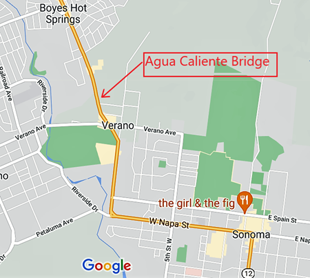
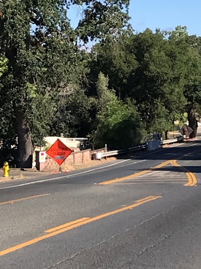
SONOMA COUNTY – Caltrans has closed the pedestrian lane on the west side of State Route 12’s Agua Caliente Creek Bridge in Boyes Hot Springs, Sonoma County. The closure, which occurred on June 29, 2021, allows Caltrans to shift traffic to the west side of the bridge, creating space on the opposite side of the bridge for workers to upgrade the guardrail connecting to the eastern bridge railing.
Caltrans is increasing the height of the guardrail to comply with current safety standards. The work has been included in the ongoing Route 12 Paving Project, which upgrades sidewalks and paves a three-mile stretch of Route 12 in the City of Sonoma and Boyes Hot Springs.
The process of upgrading guardrail will take about two months, involving closing alternate pedestrian lanes to accommodate railing upgrades on both sides of the bridge.
During the closure, pedestrians heading south towards the Agua Caliente Creek Bridge must be on the east side of the highway. The last intersection to cross to the east side via crosswalk is Siesta Way. Pedestrians heading north must cross at Verano Avenue if not already on the highway’s east side. Detour signs for pedestrians will be installed shortly.
In late July, Caltrans will reverse the process, shifting traffic to the east and closing the eastern pedestrian lane, creating space for Caltrans to upgrade the western guardrails connecting to the bridge railing.
In late July, Caltrans will reverse the process, shifting traffic to the east and closing the eastern pedestrian lane, creating space for Caltrans to upgrade the western guardrails connecting to the bridge railing.
Pedestrians will need to be on the east side of the highway by Siesta Way or Verano Boulevard.
Work on the guardrail is scheduled for completion in late August 2021.
For 24/7 traffic updates, go to 511.org: https://twitter.com/511SFBay You can also get real-time information on all State Highways in California on our Caltrans Quick Map: http://quickmap.dot.ca.gov/ Please be #WorkZoneAlert
Or follow Caltrans on Twitter at https://twitter.com/CaltransD4
Or follow Caltrans on Twitter at https://twitter.com/CaltransD4