State Route 32 Pavement Rehabilitation Project
BUTTE 32 Pavement Rehabilitation Project
Project Description:
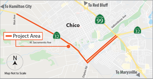
In and near Chico, from Muir Avenue to Route 99 (PM 5.0/10.2L/R). Rehabilitate pavement, install signals and lighting, upgrade Transportation Management System (TMS) elements, rehabilitate drainage systems, and upgrade facilities to Americans with Disabilities Act (ADA) standards. This project will extend the pavement service life and improve ride quality.
Project Location Map:

Purpose:
The purpose of the proposed project is to:
1. Preserve the pavement life of SR 32 (PM 5.0-10.2) by addressing poor existing
pavement conditions.
2. Extend the life of drainage systems by rehabilitating systems in poor condition.
3. Improve pedestrian mobility and overall operations by upgrading non-standard ADA ramps, adding
intersection lighting and control devices were warranted and work with the City of Chico to close
sidewalk gaps as budget allows.
4. Improve multi-modal function of the roadway per Caltrans District 3’s complete streets plan, where feasible.
Need:
The existing pavement within the project area exhibits signs of major distress and is expected to further deteriorate in the absence of proper action. A culvert assessment determined multiple culverts to be in poor condition, which jeopardizes the stability of the existing roadbed. Drainage systems that are in poor condition require rehabilitation or replacement to restore functionality. The project area has multiple curb ramps that are not compliant with the Americans with Disabilities Act (ADA). There are multiple gaps in the existing sidewalk, including substandard driveways, thus limiting pedestrian connectivity along this corridor.
Project Cost:
The total cost is estimated at $ 37.2 million in federal and state funds.
Schedule:
| Project Approval and Environmental Document | December 6, 2021 |
| Design Completed | December 1, 2023 |
| Advertise Project | March 25, 2024 |
| Begin Construction | July 10, 2024 |
| Complete Construction | May 2026 |
BUTTE 32 Pedestrian Improvements
Project Description:
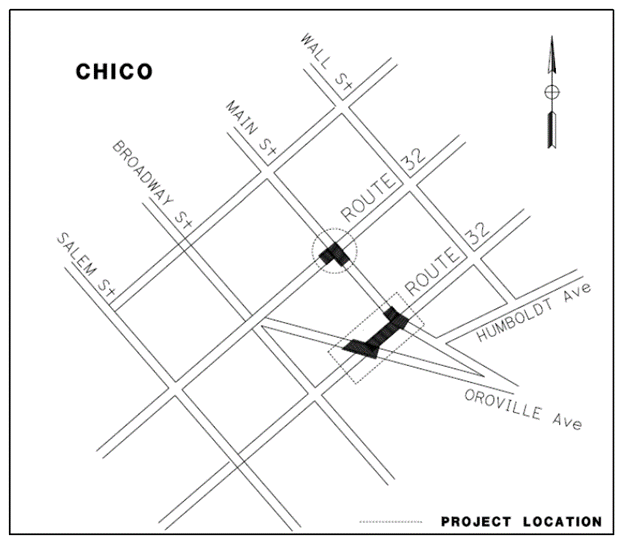
In Chico, at Main Street and Oroville Avenue (PM R9.5R/L to PM R9.57R/L). Upgrade traffic signals, install pedestrian push buttons and countdown signals, and restripe crosswalks to improve pedestrian safety. This project will reduce the number and severity of collisions.
Project Location Map:

Purpose:
The purpose of this proposed project is to reduce the number and severity of collisions involving pedestrians and vehicles at the intersection of 8th Street/Main Street, 9th Street/Main Street and 9th Street/Oroville Avenue in the City of Chico.
Need:
This project was initiated based on the 2019 Pedestrian Safety Improvement Monitoring Report. The report listed two (2) collisions involving pedestrians, which resulted in injuries that occurred at the 8th Street/Main Street intersection between 01/01/2015 and 12/31/2019.
Additional locations within the project limits along State Route (SR) 32 were investigated for pedestrian collisions during the same period. Due to pedestrian collisions in proximity to the original location, two (2) additional locations were added to this project. At the 9th Street/Oroville Avenue intersection one (1) collision occurred that resulted in an injury. At the 9th Street/ Main Street intersection two (2) collisions occurred; one (1) resulted in a fatality and one (1) resulted in injury.
Funding:
This project is programmed in the State Highway Operation and Protection Program (SHOPP) under the funding from 20.XX.201.010, Safety Improvement Program, and will be funded in the 2022/2023 FY.
Schedule:
| Project Approval and Environmental Document | December 5, 2022 |
| Design Completed | December 1, 2023 |
| Advertise Project | March 25, 2024 |
| Begin Construction | July 10, 2024 |
| Complete Construction | May 2026 |
BUT 32 Bike Ped Safety Improvements
Project Description:
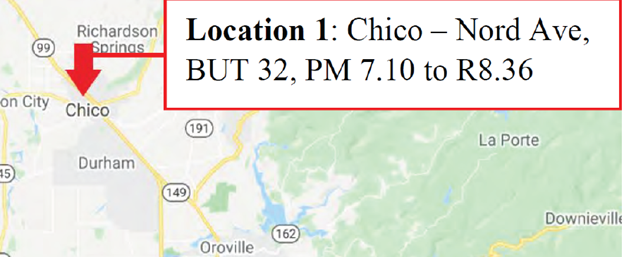
In and near Chico, from West 8th Avenue to West 2nd Street. Add green bike lane treatment, install signs, and construct curb ramps to improve pedestrian and bicyclist safety. This project will reduce the number and severity of collisions.
Project Location Map:

Purpose:
The purpose of the project is to improve safety for bicyclists and pedestrians, reduce the number of bicyclist-involved collisions, and increase visibility and awareness for pedestrians and bicyclists.
Need:
Various locations throughout District 3 were identified in the 2018 Bicyclist Safety Improvement Monitoring (Pilot) Program as locations that require corrective action to address bicyclist-involved high collision concentration locations (HCCLs) and high collision corridors. Pedestrian enhancements were identified based on evaluations of traffic and pedestrian movements.
Funding:
This project is programmed under the 20.XX.201.010 Safety Improvement program and programmed in the 2020 State Highway Operation and Protection Program (SHOPP).
Schedule:
| Project Approval & Environmental Document | August 27, 2021 |
| Design Completed | June 15,2023 |
| Advertise Project | March 25, 2024 |
| Begin Construction | July 10, 2024 |
| Complete Construction | May 2026 |
Project Contacts:
Bikramjit Kahlon, Project Manager, (530) 812-5049, bikramjit.kahlon@dot.ca.gov
Megan Reese, Public Information Officer, (530) 682-6145, megan.reese@dot.ca.gov

