Cap City Corridor Project
About the Corridor
The Cap City Corridor (State Route 51 and adjacent streets) is the most congested corridor in the region. In 2016, SR 51/Cap City experienced over 2,050,000 vehicle hours of delay at a $27.5 million cost to users and had five of the region’s top 10 bottlenecks. As the region continues to grow, conditions in the SR 51/Cap City Corridor are expected to worsen by 2035. To address the issues in the corridor and better meet the needs of drivers, transit riders, freight drivers, bicyclists, and pedestrians, Caltrans initiated the Capital City (Cap City) Corridor Project: A collaborative, interagency planning process that coordinates and prioritizes potential multimodal projects in the corridor. There is no single project that will solve all the issues. Instead, it will require a suite of short-, medium- and long-term multimodal projects with planning and funding from multiple agencies.
- HOV lanes
- A multi-use Class I path across the American River
- Neighborhood bike infrastructure
- Improved pedestrian infrastructure
- Transit projects and improved connectivity to transit stations

Project Facts
Description
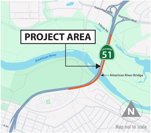
The California Department of Transportation (Caltrans), in cooperation with the City of Sacramento, Sacramento Area Council of Governments, Sacramento County, Sacramento Regional Transit, and Sacramento Transportation Authority proposes to make improvements on SR 51/Cap City between post miles 1.0 to 4.4 in Sacramento County.
Project Benefits
The proposed project would widen the existing roadway, extend the existing bus/carpool lanes, construct auxiliary lanes, improve intelligent transportation system elements, construct a new Class I bike path on the American River Bridge, and widen or replace existing structures within the project limits.
Project Schedule
2015
- Identify Project Priority/Feasibility
Fall 2016
- Prepare Project Study Report/ Project Development Support
2016-2019
- Engineering and Environmental Studies
- Prepare Project Report & Environmental Document
2019-2022
- Prepare Plans, Specifications and Estimates
- Right-of-Way Activities
- Acquire Permits
2022
- Advertise and Award Construction Contract
2023-2027
- Construction
Partnership
- City of Sacramento
- Sacramento Area Council of Governments (SACOG)
- Sacramento Regional Transit (SacRT)
- Sacramento Transportation Authority (STA)
Cap City Corridor Resources
- The Bike trip planner is a great way to find the best route for your next bicycle trip.
http://www.sacregion511.org - Check out the Transit Providers to find one in your area, and even use the Google Transit Trip Planner to find routes and times for Regional Transit, Roseville Transit or Yolo Bus services.
http://sacramento-tma.org/Commuter%20Resource%20Guide.html - Check out the seats available in vanpools, or find out how to start your own here.
http://www.sacramento-tma.org/Vanpools.html

