
District: District 3 - Marysville, dot.ca.gov/caltrans-near-me/district-3
Amarjeet S. Benipal, District Director
Contact: Steve Nelson steve.nelson@dot.ca.gov
Gilbert Mohtes-Chan gilbert.mohtes-chan@dot.ca.gov
Phone:(530) 632-0080; (530) 682-6145
FOR IMMEDIATE RELEASE
Marysville – Motorists should prepare for a warm wet winter storm sweeping through the Sacramento Valley, foothills and Sierra, making travel difficult through the weekend.
Caltrans is prepositioning equipment, resources, and personnel to strategic points to respond quickly to emergencies that may be triggered by widespread valley and foothill rain, high elevation snow, flooding and gusty winds.
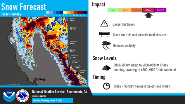
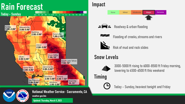
Weather forecasters predict up to 8 feet of snow is expected to accumulate over Donner Summit on Interstate 80 and more than 3 feet over Echo Summit on U.S. Highway 50 beginning today and continuing into Sunday night. As much 10 inches of rain is forecast in the foothills and mountain areas.
In the valley areas, 2-3 inches of rainfall is predicted for the Chico and Sacramento areas. Motorists are advised to be alert for possible flooded roadways, downed trees and power lines due to high winds.
Chain controls and additional travel time should be expected in mountain areas, with temporary highway closures possible due to whiteout conditions, spinouts or avalanche control work. Motorists are advised that speed limits during chain controls are reduced to 30 mph on I-80 and 25 mph on U.S. 50 and other mountain routes.
Caltrans reminds drivers to winterize vehicles by ensuring tires are properly inflated and have good tread (minimum 6/32 in snow areas), and to stock up with water, blankets, snacks, a flashlight and a full tank of gas before mountain travel.
In addition, motorists should never drive around a safety barrier or road closure sign or through flooded areas. As little as one foot of water can sweep a vehicle off the road.
Further tips for safe winter driving and information about chain controls can be found at dot.ca.gov/travel/winter-driving-tips. District 3 recommends following the National Weather Service offices in Sacramento and Reno for daily weather forecasts.
District 3 is responsible for maintaining and operating 4,385 lane miles in 11 Sacramento Valley and Northern Sierra counties. Check out Caltrans' QuickMap for current road conditions and chain requirements at quickmap.dot.ca.gov/ or download the free QuickMap app on the App Store or Google Play. Motorists also can call the California Highway Information Network automated phone service at 1-800-427-ROAD (7623).
###