
District: District 3 - Marysville
Contact: Angela DaPrato
Phone: (916) 826-3093
FOR IMMEDIATE RELEASE
Sacramento — Motorists heading to the Sierra this weekend expect major travel delays due to a forecasted snow storm and the closure of U.S. Highway 50 in El Dorado County.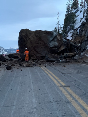
US-50 is currently closed in both directions due to a massive boulder in the middle of the highway at Echo Summit. CHP is turning eastbound motorists around at Sly Park Road and Sierra-at-Tahoe, and detouring westbound travelers at State Route 89 Junction and Meyers. Motorists are advised to use Interstate 80 as an alternate route.
Motorists heading to the Sierra should avoid using back road due to an expected snow storm. The National Weather Service issued a winter weather advisory predicting hazardous mountain travel and encourages motorists to avoid traveling Friday afternoon through at least Saturday morning. Meteorologists are predicting four to eight inches of snow over the higher peaks above 4,000 feet and one to four inches above 2,500 feet. Motorists should expect slippery roads, snow covered roads and reduced visibilities at times. Chain controls is possible, and it is essential you carry chains.
US-50 was closed on Thursday, March 3, 2022 around 6 p.m. due to a rock slide at Echo Summit. Crews worked throughout the night prepping for blasting operations by drilling holes into the boulder. Crews are scheduled to perform blasting operation this morning and repair guard rail damaged by the rocks. Once crews have deemed the roadway conditions are safe for motorists, Caltrans will reopen US-50.
There is no estimated time of when US-50 will reopen.
Motorists preferring not use I-80 as alternate route can use the scenic gold country routes in the counties of El Dorado and Amador. However, there is a possibility the routes could be closed due to the snow. Motorists should allow at least one-hour extra travel time to reach South Lake Tahoe. The alternate routes available are:
- From Sacramento to Nevada: From US-50 take the Power Inn Road Exit to SR-16 east, to SR-49 south, to SR-88 east then to SR-89 north.
- From Placerville to Nevada: From US-50 take SR-49 south to SR-88 east then to SR-89 north into South Lake Tahoe.
- From the East Bay to Nevada: Take SR-88 east in Stockton to SR-88 south then to SR-89 north into South Lake Tahoe.
- From Reno/Carson City to the Sacramento area: Take Nevada SR-88 south to California SR-88 west then onto SR-88 to US-50 into Placerville. Or take SR-49 north to SR-16 west then to US-50 west towards El Dorado Hills/Folsom.
- From South Lake Tahoe to the Sacramento area: Take SR-89 to SR-88 west then take SR-49 north to US-50 into Placerville or take SR-49 north to SR-16 west then to US-50 west towards El Dorado Hills/Folsom.
Motorists coming through the Stockton area can exit SR-99 to SR-88 east, continuing onto SR-88/49. In Jackson, turn left to continue on SR-88 east. At SR-89 turn left (north) and follow it to US-50 into South Lake Tahoe.
Caltrans reminds drivers to winterize vehicles by ensuring tires are properly inflated and have good tread, and to stock up with water, blankets, snacks, a flashlight and a full tank of gas before mountain travel. Further tips for safe winter driving and information about chain controls can be found at dot.ca.gov/travel/winter-driving-tips.
Motorists also are reminded to carry traction-control devices in their vehicles as permitted highway chain installers do not sell traction devices. Periods of chain control are anticipated during the storm with posted speed limits of 30 mph on Interstate 80 during chain-enforcement periods.
Check out Caltrans' “QuickMap” for current road conditions and chain requirements at quickmap.dot.ca.gov/ or download the free QuickMap app on the App Store or Google Play. Motorists also can call the California Highway Information Network automated phone service at 1-800-427-ROAD (7623).
###