
The roads not traveled – until further notice
Caltrans Headquarters photograph
Mile Marker presents three examples of long-term roadway closures that Caltrans has been addressing for quite some time
Roadways can be closed every now and then due to something invading from above, beside, or below – be it snow or rain, rocks, dirt or a combination of objects that somehow compromise a safe driving surface.
Usually, Caltrans Maintenance crews can clear off the roads or quickly patch them up. When there is foundational or structural damage, Construction and possibly other departmental divisions become involved.
Rarely, a highway closure rises to the catastrophic level, causing loss of life and/or being profoundly disruptive to traffic flow. The collapse of a portion of the San Francisco-Oakland Bay Bridge in October 1989 and the coast-side washout of State Route 1 at Rat Creek in January 2021 are two examples. In those and other such cases, the state employs emergency measures to reopen the roadways as soon as possible, with speed being the top priority while cost – still very important and closely monitored – is a subordinate concern.
Occasionally, portions of highways are blocked off due to damage that cannot be quickly repaired, and the closures do not pose major disruptions to the needs of commerce, tourism, or local navigation. So, their re-openings can take a while – years, even – as Caltrans and other involved parties weigh the environmental and cost impacts and formulate the engineering.
Following are three examples of long-term roadway closures that Caltrans has been addressing for quite some time, the first of which is finally beginning to see a light at the end of the rock tunnel.
Ferguson Rock Shed Project
During the darkness sometime in the early morning hours on a December day in 2006, a small shift of the earth caused a massive rockfall to bury State Route 140 in Mariposa County under 800,000 cubic yards of rock, enough to fill nearly 44,500 full-sized dump trucks. Luckily, the road was empty at the time of the incident.
Anyone who since has motored past the massive slide, which occurred on the north-facing slope the scenic Merced River canyon between Mariposa and Yosemite National Park, likely was amazed by the extent of it. The idea of re-opening the thoroughly obliterated roadway, which was beset by a second massive slide in late 2015, to an untrained eye can look impossible. The “temporary” detour of two stoplight-regulated one-way steel bridges across the river from and back to the original State Route 140 sure seemed to have an air of permanence.
Caltrans, however, is not so easily deterred. The department was in the midst of shoring up the slope and re-opening the stretch of roadway before the 2015 re-burial, and since then has pursued a different solution.
Project alternatives considered along the way included exploring options to bore a tunnel through the mountain, build a bridge around it, or construct a protective rock shed over the roadway. Building the rock shed was determined to the best solution as it maintained the existing road alignment, resulting in less land disturbance and helping protect such creatures as the threatened limestone salamander. The new design dramatically increases protection for workers and will help protect the project schedule and budget.

This artist's rendering suggests what the rock shed will look like once completed along State Route 140 west of Yosemite National Park.
Caltrans District 10 illustration
Once it was determined that a rock shed was viable for a project, it became clear that the original plan for traditional “cast-in-place” construction had to be reconsidered. Caltrans designers from District 10 (Stockton region, eastward to the Nevada border) including Grant Schuster and Caroline Reyes developed an innovative solution to construct a 750-foot, segmentally constructed launched rock shed structure on the same alignment that will be built outside of the rock fall zone and then launched into place.
The installed segments will provide shelter for workers so that the entire process takes place under the protective cover of the structure as each segment is moved into place.
The project construction has been split in two distinct construction projects. Phase 1, completed in 2021-2022 for $22.7 million, employed blasting operations and remote-controlled equipment to remove 147,000 tons of talus material and install cable net drapery to minimize additional rock fall.
Phase 2, which in 2019 was estimated to cost $175 million and take five years, is the rock-shed construction on the same alignment as the original road. It will consist of 11 pre-cast concrete segments and have an interior width of 40 feet. Its restraining base will be anchored by 200 rock anchors and 400 concrete micro piles.
The purpose of the project is to restore full access to State Route140 providing a reliable route within the limits of the Ferguson Slide area and to keep the roadway open to vehicular and bicycle traffic, including large commercial trucks, emergency vehicles, and recreational vehicles. It is needed because access to Yosemite National Park and the community of El Portal has been severely restricted the past 17 years, resulting in significant economic losses.
Route 25 Curve Alignment Restoration
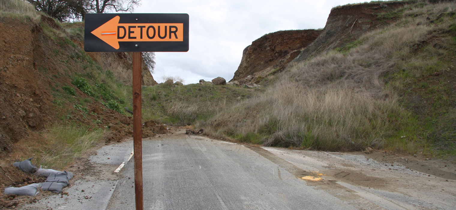
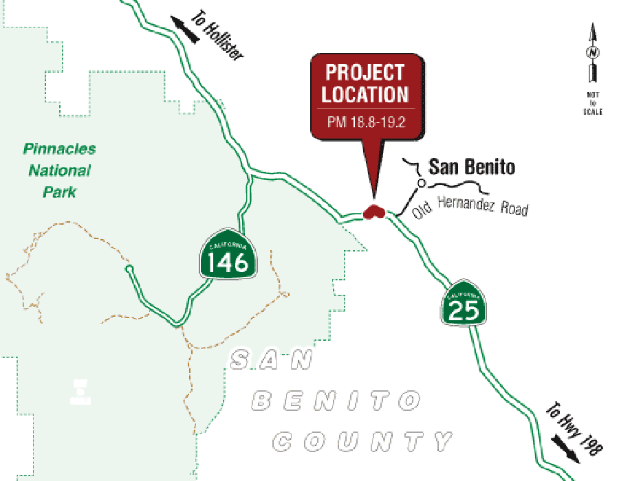
Almost a decade ago, Caltrans addressed a safety concern in District 5 when it realigned a short portion of State Route 25 in San Benito County, approximately 32 miles south of the city of Hollister. That location had sustained a higher-than-average number of collisions when compared with similar roadways throughout the state.
It only takes a minute to drive the detour along State Route 25 near San Benito, although a stoplight can cause further delays.
District 5 mapIn December 2015, construction was completed on the project where a tight curve was straightened by cutting back slopes through a hillside and realigning the roadway. Soon afterward, however, the cut slopes on both sides began to fail, and the newly constructed roadway needed to be closed for the safety of the traveling public.
Under an emergency project, a temporary detour was constructed to the east of the historic roadway alignment and continues functioning today with temporary stop signs with flashing beacons to allow traffic to continue. The Route 25 Curve Alignment Restoration will provide a permanent solution.
As soon as early 2024, Caltrans looks to complete flattening the cut slopes to 2:1 (horizontal to vertical dimensions) to reduce erosion, promote vegetation regrowth, and prevent repeated slope failure. The horizontal curves and banking of the roadway will allow vehicles to travel through the curve more safely.
Approximately 72,000 cubic yards of material will need to be excavated. The project will construct two 12-foot lanes with 4-foot outside shoulders. Because the existing right of way cannot accommodate the proposed flattening of the slopes, additional permanent right-of-way acquisition is required.
It is estimated that 17 blue oak trees and one valley oak tree may need to be removed to accommodate the proposed project. Impacts to trees will be offset by replacement planting within the project limits. In total, a minimum of 191 blue oak trees will be planted within the proposed planting areas. A three-year plant establishment period is proposed.
The project's estimated cost is $14 million, subject to change as progress continues.
State Route 39 Reopening Project
Whereas the closures of State Routes 140 and 25 described above were initiated in the 21st century, the same cannot be said for the shutdown of a 4.4-mile stretch of State Route 39 in the Angeles National Forest. That District 7 closure dates back to Edmund G. Brown’s first of four gubernatorial terms, the disco days of the late 1970s.
The two-lane highway heads north from Azusa in the San Gabriel Valley for 30 zigzaggy miles to State Route 2, also known as the Angeles Crest Highway. The northernmost segment of State Route 39 has been closed to public highway traffic since 1978 as the roadway is regularly damaged by landslides, flooding, falling rocks and forest fires. In 2003, the closed highway was opened to emergency crews after a Caltrans study showed reopening it would not harm wetlands, air and water quality, natural vegetation or threatened plants and animals.
Maintenance activities have included the cleaning of drainage culverts and the erection of a dirt berm. With these past improvements, the roadway is passable, but only open to emergency service vehicles.
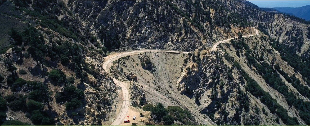
The fate of State Route 39's long-closed portion has not been determined, although several possibilities are being considered.
Caltrans District 7 photograph
Some people (business owners and recreational enthusiasts among them) adamantly want it reopened, while others (small-town residents concerned with traffic and pollution, and wildlife advocates) are just as spirited in their opposition. Caught in the middle are the estimated 417 bighorn sheep who call the region home. They often have been spotted crossing or even merely standing on the emergency road. The sheep, of which there are about 5,000 total in California, are protected and any injury or death caused by vehicles or road crews would represent a violation of state law.
Caltrans is contemplating ways to possibly reopen the long-closed 4.4-mile portion. Last December, the department hosted a public scoping meeting during which six project alternatives were presented and public input was solicited. The alternatives are:
- No build, which proposes to maintain the existing conditions of the roadway without any improvements.
- Minimum build, which proposes limited roadway restoration. Access to the roadway would be strictly for emergency service responders and maintenance access. The roadway would continue to be closed to public highway traffic.
- Active transportation access, which proposes to restrict access to the roadway to recreational related activities (e.g., enjoying vista views, hiking, biking, picnicking, camping, fishing, etc.) and allow only onsite shuttle service to operate and ferry national forest visitors through the restricted roadway adhering to a maximum speed of 15 mph and exercising extreme caution at well-marked wildlife crossings. This alternative also proposes two sustainable public parking areas, at both ends of the reopened stretch, to be constructed for visitors to park their vehicles and bikes. The main structural features include on major viaduct structure, two rock-sheds, and six soldier pile retaining walls.
- Full opening, which proposes to rehabilitate and reopen the closed segment of State Route 39 to public traffic and provide unrestricted access. A roundabout feature is also proposed at the intersection of State Routes 2 and 39. The main structural features include one major viaduct structure, two rock-sheds, four viaduct/wildlife crossing structures, and six soldier pile retaining walls.
- Viaduct construction, which proposes to construct a 4.4-mile-long standard two-lane elevated viaduct structure adjacent to the existing roadway. The continuous elevated viaduct would bypass the slide area and allow wildlife, slide debris, and water runoff to pass underneath the highway. The proposed bridge section would consist of a 10-foot-wide outside shoulder and a 12-foot-wide lane in each direction.
- Single travel lane, which proposes to construct a single travel lane having a total roadway width of 20 feet (12-foot travel lane with a 4-foot-wide shoulder on each side of the travel lane). The lane would be shared by all traffic with room to pull over and allow on-coming vehicles to pass safely.
Costs and timeframes for each of the six alternatives vary greatly. Caltrans continues to analyze the situation and related feedback, and looks to proceed with a finalized plan within a few years.
Sources: Bob Highfill, District 10 information officer; Brandy Rider, District 5 project manager; and Karl Price, District 7 senior environmental planner