
Yolo 80 Corridor Improvements Project
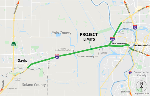
The California Department of Transportation (Caltrans), in collaboration with stakeholders, proposes to construct improvements consisting of managed lanes, pedestrian/bicycle facilities, and Intelligent Transportation System (ITS) elements along Interstate 80 (I-80) and United States Route 50 (US-50) from the Solano/Yolo County line, through Yolo County, and to West El Camino Avenue on I-80 and Interstate 5 (I-5) on US-50 in Sacramento County.
Caltrans, as assigned by the Federal Highway Administration (FHWA), is the lead agency under the National Environmental Policy Act (NEPA) for the Caltrans EA 3H900 Yolo 80 Managed Lanes Project (project). Caltrans is also the lead agency under the California Environmental Quality Act (CEQA).
Purpose and Need
Purpose
The purpose of the proposed project is to:
- Ease congestion and improve overall person throughput1.
- Improve freeway operation on the mainline, ramps, and at system interchanges.
- Support reliable transport of goods and services throughout the region.
- Improve modality2 and travel time reliability.
- Provide expedited traveler information and monitoring systems.
Need
The proposed project is needed for the following reasons:
- Recurring congestion during the AM and PM peak periods exceeds current design capacity limiting person throughput.
- Operational inefficiencies lead to the formation of bottlenecks due to short weaving and merging areas as well as lane drops.
- Inefficient movement of goods and services impedes regional and interstate economic sustainability.
- The corridor users rely heavily on single occupancy vehicles, with limited multi-modal options such as transit, carpool, bicycle, and pedestrian facilities resulting in unreliable travel times.
- Lack of real time traveler information and coordinated traffic communication systems impedes timely response to roadway incidents resulting in secondary collisions and increased non-recurring congestion.
1 Throughput is the number of people moving efficiently through a region.
2 Modality is the variety in modes of transportation. This includes access and multiple options for the movement of people and goods. Examples include access to transit, carpool, bicycle, and pedestrian facilities.
Project Alternatives
This section describes alternatives that were developed to meet the purpose and need of the project. The preferred alternative is 4B.
- Build Alternative 2a: Add a high-occupancy vehicle lane in each direction for use by vehicles with two or more riders (HOV 2+).
- Build Alternative 2b: Add a high-occupancy vehicle lane in each direction for use by vehicles with two or more riders (HOV 2+) and build an I-80 managed lane direct connector.
- Build Alternative 3a: Add a high-occupancy toll lane in each direction for free use by vehicles with two or more riders (HOT 2+). Single-occupied vehicles would pay a fee for lane usage.
- Build Alternative 3b: Add a high-occupancy toll lane in each direction for free use by vehicles with two or more riders (HOT 2+) and build an I-80 managed lane direct connector. Single-occupied vehicles would pay a fee for lane usage.
- Build Alternative 4a: Add a high-occupancy toll lane in each direction for free use by vehicles with three or more riders (HOT 3+). Vehicles with less than three riders would pay a fee for lane usage.
- Build Alternative 4b: Add a high-occupancy toll lane in each direction for free use by vehicles with three or more riders (HOT 3+) and build an I-80 managed lane direct connector. Vehicles with less than three riders would pay a fee for lane usage.
- Build Alternative 5a: Add an express lane in each direction (i.e., everyone would pay a fee to use the lane, regardless of the number of riders).
- Build Alternative 5b: Add an express lane in each direction (i.e., everyone would pay a fee to use the lane, regardless of number of riders), and build an I-80 managed lane direct connector.
- Build Alternative 6a: Add a transit-only lane in each direction.
- Build Alternative 6b: Add a transit-only lane in each direction and build an I-80 managed lane direct connector.
- Build Alternative 7a: Repurpose the current number one general-purpose lane for use by vehicles with two or more riders (HOV 2+); no new lanes would be constructed.
- Build Alternative 7b: Repurpose the current number one general-purpose lane for use by vehicles with two or more riders (HOV 2+); no new lanes would be constructed. Build an I-80 managed lane direct connector.
Total Project Cost - $465M
Schedule
Draft Environmental Document (DED) for Public Review: November 13, 2023
Public Circulation Comment Period End: January 12, 2024
Final Environmental Document and Clearance Complete: May 1, 2024
Design Complete: May 10, 2024
Construction Start: Fall 2024
Final Environmental Document (2024)
Final Environmental Document is located here (State Clearing House Link)
Accessibility Assistance: Caltrans makes every attempt to ensure our documents are accessible. Due to variances between assistive technologies, there may be portions of this document which are not accessible. Where documents cannot be made accessible, we are committed to providing alternative access to the content. Should you need additional assistance, please contact us at (916) 654-2852 (and/or a division contact) or visit https://dot.ca.gov/request-ada-compliant-documents
Cover TitlePage_FONSI_Summary (PDF)
Table of Contents (PDF)
Chapter 1 Proposed Project (PDF)
1.1 Introduction
1.1.1 Project Background
1.2 Purpose and Need
2.1 Purpose
1.2.2 Need
1.2.3 Independent Utility and Logical Termini
1.3 Project Description
1.3.1 Project Alternatives
1.4 Comparison of Alternatives
1.5 Alternatives Considered but Eliminated from Further Discussion Prior to Draft EIR/EA
1.5.1 Alternative 1A
1.5.2 Alternative 1B
1.5.3 Alternative 1C
1.5.4 Alternative 1D
1.5.5 Alternative 2
1.5.6 Alternative 4
1.5.7 Alternative 5
1.5.8 Alternative 6
1.6 Permits and Approvals Needed
Chapter 2 Affected Environment, Environmental Consequences, and Avoidance, Minimization, and/or Mitigation Measures (PDF)
2.1 Human Environment
2.1.1 Existing and Future Land Use
2.1.2 Consistency with Regional, and Local Plans and Programs
2.1.3 Parks and Recreational Facilities
2.1.4 Farmlands
2.1.5 Growth
2.1.6 Community Character and Cohesion
2.1.7 Environmental Justice
2.1.8 Equity
2.1.9 Utilities and Emergency Services
2.1.10 Traffic and Transportation/Pedestrian and Bicycle Facilities
2.1.11 Visual and Aesthetics
2.1.12 Cultural Resources
2.2 Physical Environment
2.2.1 Hydrology and Floodplain
2.2.2 Water Quality and Storm water Runoff
2.2.3 Geology/Soils/Seismic/Topography
2.2.4 Paleontology
2.2.5 Hazardous Waste and Materials
2.2.6 Air Quality
2.2.7 Climate Change
2.2.8 Noise
2.2.9 Energy
2.3 Biological Environment
2.3.1 Natural Communities
2.3.2 Wetlands and Other Waters
2.3.3 Plant Specie
2.3.4 Animal Species
2.3.5 Threatened and Endangered Species
2.3.6 Invasive Species
2.4 Cumulative Impacts
2.4.1 Regulatory Setting
2.4.2 Methodology
2.4.3 Resources Excluded from Cumulative Impacts Analysis
2.4.4 Resources Evaluated for Cumulative Impacts
2.4.5 Resource Study Area
Chapter 3 California Environmental Quality Act Evaluation (PDF)
• 3.1 Determining Significance Under CEQA
• 3.2 CEQA Environmental Checklist
3.2.1 Aesthetics
3.2.2 Agriculture and Forest Resources
3.2.3 Air Quality
3.2.4 Biological Resources
3.2.5 Cultural Resources
3.2.6 Energy
3.2.7 Geology and Soils
3.2.8 Greenhouse Gas Emissions
3.2.9 Hazards and Hazardous Materials
3.2.10 Hydrology and Water Quality
3.2.11 Land Use and Planning
3.2.12 Mineral Resources
3.2.13 Noise
3.2.14 Population and Housing
3.2.15 Public Services
3.2.16 Recreation
3.2.17 Transportation
3.2.18 Tribal Cultural Resources
3.2.19 Utilities and Service Systems
3.2.20 Wildfire
3.2.21 Mandatory Findings of Significance
3.3 Wildfire
3.3.1 Regulatory Setting
3.3.2 Affected Environment
3.3.3 Environmental Consequences
3.3.4 Avoidance, Minimization, and/or Mitigation Measures
3.4 Climate Change
3.4.1 Regulatory Setting
3.4.2 Environmental Setting
3.4.3 GHG Inventories
3.4.4 Project Analysis
3.4.5 CEQA Conclusion
3.4.6 Greenhouse Gas Reduction Strategies
3.4.7 Adaptation
Chapter 4 Comments and Coordination (PDF)
4.1 Public Scoping and Participation
4.1.1 Stakeholder Meetings
4.1.2 Project Development Team Meetings
4.2 Consultation and Coordination with Public Agencies
4.2.1 Federal Agencies
4.2.2 State Agencies
4.2.3 Native American Tribal Consultation
4.2.4 Stakeholder-Specific Actions – Equitable Outreach
Chapter 5 List of Preparers (PDF)
Chapter 6 Distribution List (PDF)
Appendix A Section 4(f) Findings for the I-80 Corridor Improvements Project
Appendix B Title VI Policy Statement
Appendix C Avoidance, Minimization, and/or Mitigation Measures Summary
Appendix D List of References
Appendix E Standard Measures
Appendix F Abbreviations and Acronyms
Appendix G Notice of Preparation
Appendix H List of Technical Studies
Appendix I Preliminary Design Plans
Appendix J Air Quality Calculations and Conformity Determination
- Appx_J1-03-3H900_AQReport_April2024_508
- Appx_J2-03-3H900 (Roadway) Detailed Report_Final_508
- Appx_J3-03-3H900 (Bridge) Detailed Report_Final_508
- Appx_J4-SMAQD_HealthEffectsTool_Opening-Year_508
- Appx_J5-SMAQMD_HealthEffectsTool_Year-2049_508
- Appx_J6-Yolo80SACOG-MTP-Project-List-I-80_508
- Appx_J7-Yolo80_ProjectLevelConformity_508
- Appx_J8_FHWA-Conformity-Determination-Letter_508
Appendix K State Historic Preservation Officer Determinations of Eligibility
Appendix L Assembly Bill 52 Consultation
Appendix M U.S. Fish and Wildlife Service Biological Opinion
Appendix N Species Lists
VMT Mitigation Plan
Transportation Analysis Report
Circulation Material
- Public Notice of Availability (NOA) (PDF)
- Summary Form (PDF)
- Notice of Completion (NOC) (PDF)
- Notice of Preparation (NOP) (PDF)
- Notice of Determination (NOD) (PDF)
- CEQA Statement of Overriding Considerations (PDF)
- CEQA Findings (PDF)
Interagency Consultation Package
Technical Studies
Community Impact Assessment
Air Quality Report
Cumulative Impact Hydraulics Study
Natural Environmental Study
Memorandum
Paleontological Identification Report
Floodplain Hydraulics Study
Initial Site Assessment
Traffic Analysis Report
NES Appx C Botanical Resources
NES Appx D Aquatic Resources Survey
NES Appx E Giant Garter Snaker Habit
NES Appx F BatHabitat Assessment
Nes Appx G Tricolored Black Bird Nesting Habitat Assessment
NES Appx H Swainson Hawk
NES Appx I Burrowing Owl Protocol Survey Results
NES Appx J Valley Elderberry Longhorn Beetle Habitat Assessment
Noise Abatement Decision Report
Noise Study Report
VTM Mitigation Memo
VTM Mitigation Plan
Contact Us
Gurtej Bhattal
Project Manager
Masum A Patwary
Environmental Coordinator
Dennis Keaton
Public Information Officer
Comments:
Yolo80corridor@dot.ca.gov
Helpful Links
- Check out the Transit Providers to find one in your area, and even use the Google Transit Trip Planner to find routes and times for Regional Transit, Roseville Transit or Yolo Bus services.
- Check out the Seats Available in vanpools, or find out how to start your own here.